Pennypack Creek Watershed
Environmental Decision Toolkit
- EDT Projects
- National
- Regional
- Place Based
More Information
- Pennypack Watershed final report (PDF) 183 pp., 12.1MB, About PDF
Introduction
The Pennypack Watershed is located in southeastern Pennsylvania and is heavily influenced by the urban and suburban areas of northeast Philadelphia. While the watershed is home to over 250,000 residents, there are significant remaining natural landscapes, rural farms, and protected park lands. Efforts over the years by the Philadelphia Water Department and the Pennypack Watershed Partnership have been made to improve water quality, the environment, and the quality of life of residents. Of particular concern was to reclaim water resources of the urban streams of the watershed that have been heavily impacted by humans.
Objectives
The objectives of the project were to assemble individuals from the federal, state, and local levels of government; local universities; and non-government organizations (NGOs) to
- Determine whether the ReVA modeling approach can be scaled down so as to be informative and appropriate for watershed assessment in the Commonwealth of Pennsylvania;
- Determine whether the assessment model developed for the Pennypack can be used as a "template" for assessments in other watersheds in Pennsylvania and elsewhere; and
- Determine whether the ReVA modeling process can be used to develop watershed sustainability goals and indicators.
Data & Methods
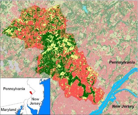
The Pennypack Creek Watershed (Pennsylvania) showing the degree of urbanization (pink), forested (greens) and crops/pasture (yellows).
- Biological (fish, habitat, and macroinvertebrate) data
- Water Related (wetland delineation, bridges & culverts, dams, riparian buffers, discharges & withdrawls, base, flow, floodplain) data
- Geological (bed rock, soils) data
- Demographic household density, median household income, population density) data
- Land use (land cover, tree canopy density, impervious surface, slope, road density, forest fragmentation) data
Conclusions
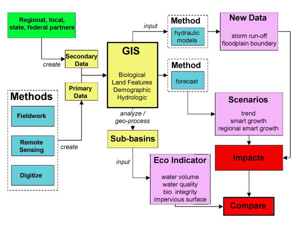
The Pennsylvania team concluded that the ReVA modeling approach can be scaled down so as to be informative and appropriate for smaller watershed assessments in the Commonwealth of Pennsylvania. The basic steps are outlined in the image below and are: (a) development of a GIS data inventory; (b) assessment of the state of the watershed; (c) projection of alternative future land-use scenarios; and (d) assessment of differential impacts of the scenarios. While many larger-scale ReVA assessment tools and data variables are too coarse for assessment at the local level, it is feasible to use such processes with more refined local data to accurately outline the impacts of alternative land use and resource allocation decisions on ecological and other watershed attributes.The approach developed for the Pennypack Creek Watershed (PCW) also can be used as a template for other watersheds. While the PCW is a seriously impaired watershed in a dense urban setting in the Greater Philadelphia region, the assessment protocol outlined in this study can be accurately applied for less developed and more pristine watersheds as well. The report outlines data needs and analytical tools for this information transfer. The PEVA team urges others conducting such studies to create a multi-disciplinary study team and consider developing a central and accessible GIS database that includes both spatial and non-spatial data.
Finally, the ReVA modeling process also can be used to develop watershed sustainability indicators. The PEVA team outlined four broad indicator categories that can be applied elsewhere and aggregated to larger regions in Pennsylvania. It should be noted, however, that for many water quality and biological variables, good time series information is not available. Linking land-use change to changes in water quality and biological diversity is difficult. Fortunately, new models and better topographic and hydrologic information allow researchers to more accurately assess variables such as water volume and impervious surface under different future conditions.