Regional Growth Decision Toolkit
Environmental Decision Toolkit
- EDT Projects
- National
- Regional
- Place Based
Introduction
EPA and the SEQL partners recognized that addressing the increasingly complex environmental problems of a region would require an integrative and innovative approach. Drawing on the scientific resources of ReVA and the SEQL partners’ knowledge of the region, the process of developing a regional growth decision tool was initiated. ReVA is assisting this effort in two key ways:
1) Develop and analyze one current and two alternative future scenarios
SEQL partners and ReVA conducted several workshops with planners, policy makers, and real estate agents to develop three regional growth scenarios:
1) Year 2000 Actual - This scenario captures current environmental and socioeconomic conditions in the SEQL region and highlights the present spatial pattern of development.
2) 2030 Medium Density Scenario - The 2030 medium density scenario is based on population-driven changes that continue according to past development patterns (figure on the right).
3) 2030 Compact Centers Scenario - The compact centers scenario explored the feasibility of directing the majority of projected growth toward existing municipalities and other "regional centers," thereby preserving the outlying area from unchecked sprawl (figure on the left).
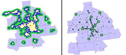
The medium density scenario (right) and compact center scenario (left) used for the regional growth decision toolkit
2) Develop a web-based tool to inform regional decision makers
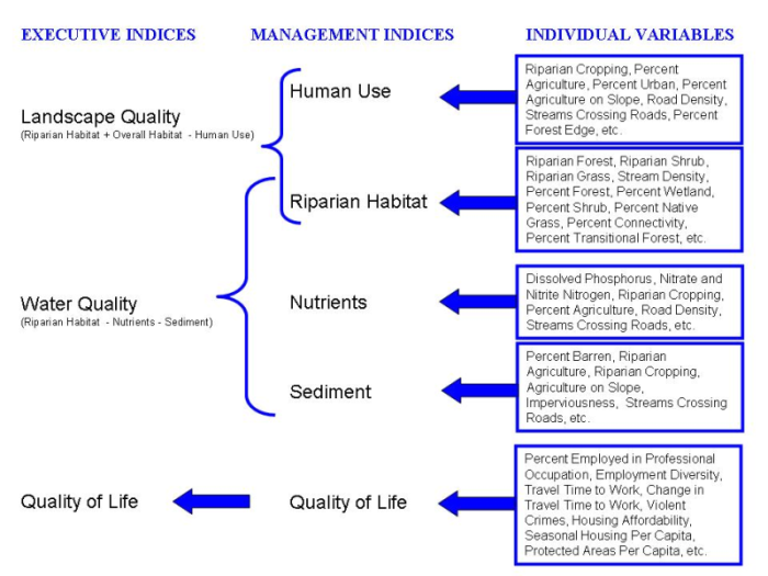
The EPA/SEQL partnership has compiled and developed a suite of nearly 100 spatial coverages ranging from land use/land cover information to a housing affordability index. To efficiently transmit the information and results from this research effort, a web-based tool was developed with three levels (see figure below):
-
Executive Summary level - A web-tool that allows high-level policy makers and elected officials to download presentation materials, view summary maps of current conditions, and compare differences between future development scenarios.
-
Management Summary level - A web-tool that allows planners and land-use managers to view individual indicators, view indices of environmental condition, and compare implications of future development scenarios.
-
Data Exploration level - A web-tool that allows data managers and data analysts to explore data, create new indices and modify variables.