Southeast - EDT
Environmental Decision Toolkit
- EDT Projects
- National
- Regional
- Place Based
Introduction
The Southeastern Environment Decision Toolkit (SE-EDT) is designed to identify locations where the overlap of high air toxics concentrations and vulnerable ecological resources or human populations warrant further study.
The southeastern United States has a combination of valuable ecological resources, widespread urban development, and high levels of emitted air toxins. Wildlife populations and their habitats may be vulnerable to acute and chronic impacts from ambient air concentrations toxic polluants. Human populations may also be at risk, particularly vulnerable populations such as children and the elderly. The ReVA team is integrating air, water, soil, land use, and other geospatial data to present a multi-media characterization of potential vulnerabilities in EPA Region 4. Using modeled wildlife habitat data, human demographic data, and modeled air concentrations of hazardous air pollutants, the SE-EDT can highlight vulnerable locations across the region (see figure).
The Clean Air Act as amended in 1990 currently lists 188 hazardous air pollutants (HAPs). Of these chemicals, some are bioaccumulative - they persistant in the environment and accumulate in living tissue to become concentrated at higher levels of the food chain. This bioaccumulation magnifies air toxic impacts; relatively benign ambient air concentrations across large areas can accumulate to significant levels in living organisms. By focusing on the regional scale patterns of air toxics concentrations, wildlife habitats, and vulnerable human populations, the SE-EDT can help decision makers better understand where air toxics research or mitigation should be focused on the ground.
Objectives
The goal of the SE-EDT is to model and interpret the interrelationships between air toxics concentrations and vulnerable ecological and human resources with a focus on both direct (i.e., inhalation) and indirect (i.e., chemical deposition with subsequent contact) exposure pathways of persistant bioaccumulative toxins.
There is very little data on how direct exposure affects wildlife and habitats, and thus this project must concentrate on indirect bioaccumulation pathways for those species. Direct impacts to humans are better understood and published data and reports are used where available for particular chemicals. The main objectives are to:
- Identify habitats throughout the Southeast for guilds of species that are potentially vulnerable to HAPs and other non-criteria pollutant air toxics.
- Identify human populations that are potentially vulnerable to HAPs and other non-criteria air toxics, through both direct and indirect exposure pathways.
- Use geospatial modeling to identify areas of overlap between high concentrations of air toxics and vulnerable ecological and human endpoints.
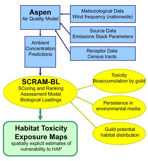
Flowchart depicting the development of habitat toxicity exposure maps for the Southeast
Data & Methods
Human health vulnerability combined mortality statistics with demographic data to determine spatially explicit locations of potentially sensitive populations. Habitat vulnerability hierarchically combined ecosystems which harbor guilds of species which may be vulnerable to air toxics and where possible, rare and sensitive individual species data. A particular goal of the habitat modeling effort is to to carefully note, at both hierarchical levels, assumptions and produce the best available picture of sensitive resource distributions in the Southeast.
In addition to exposure to toxics, numerous ecological and human health variables are being combined with other stressors (roads, non-point source pollution) and resources (riparian forest, wetlands) using a suite of ReVA integration methods to assess overall regional vulnerability.
Data from the following sources are being used:
National Air Toxics Assessment
National Air Toxics Assessment (NATA) will be used for spatially explicit data on the distribution of air toxics data. The purpose of NATA is to provide a national scale assessment is to identify and prioritize air toxics, emission source types and locations which are of greatest potential concern in terms of contributing to population risk. EPA uses the results of these assessments to 1) work with communities in designing their own local-scale assessments; 2) set priorities for improving data in emissions inventories; and 3) help direct priorities for expanding and improving the network of air toxics monitoring.
Assessment System for Population Exposure
Data from the Assessment System for Population Exposure (ASPEN) will be used in combination with habitat or human health data to identify potentially sensitive populations across the region. ASPEN is an EPA model which estimates mobile and non-mobile ambient air concentrations of toxics by census tract. ASPEN simulates the behavior of the pollutants after they are emitted into the atmosphere and uses estimates of toxic air pollutant emissions and meteorological data from National Weather Service Stations to estimate air toxics concentrations nationwide.
Center for Disease Control
County level cardiovascular, respiratory, and neurological mortality statistics from the Center for Disease Control (CDC) will be used to develop human vulnerability assessments.
Small Area Income and Poverty Estimates
Estimates of population having health insurance came from the US Census Bureau's Small Area Income and Poverty Estimates (SAIPE) and were used with additional Census 2000 data to determine the location of potentially sensitive human populations. The Census Bureau SAIPE program is designed to provide more current estimates of selected income and poverty statistics than those from the most recent decennial census.
Southeastern Gap Analysis Project
Diversity and abundance measures for the various wildlife guilds were derived using Southeastern Gap Analysis Project (SEGAP
) data. SEGAP provides data and assistance for the regional assessments of the conservation status of native vertebrate species and natural land cover types in the Southeast and facilitates the application of this information to land management activities.
Partners
EPA Region 4, including the offices of Air, Pesticides, and Toxics Management Division (APTMD), the Science and Ecosystem Support Division (SESD), the Water Management Division (WMD), and the Planning and Analysis Branch (PAB), and
EPA Office of Research and Development, National Exposure Research Laboratory (NERL).