National Ecosystem Assessment Toolkit
Environmental Decision Toolkit
- EDT Projects
- National
- Regional
- Place Based
Introduction
The National Ecosystem Assessment Toolkit (NEAT) project will expand upon efforts currently underway in SE-EDT to develop a similar tool at the national scale. NEAT will be a user-friendly and interactive web-based software application designed to provide users with the capability to conduct three main types of analyses at the national level: (1) HAPs Proximity Analysis, (2) Air Pollutants Analysis, and (3) Track Air Pollution Trends over time.
NEAT is assimilating available air, water, soil data, and other land use, ecological, and demographic data to present a multi-media characterization of potential vulnerabilities of ecosystems and human health to toxic air.
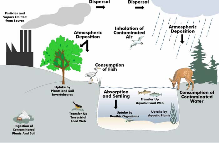
The Clean Air Act as amended in 1990 lists 189 hazardous air pollutants (HAPs), and also provides formal procedures to add or subtract chemicals from that list. However very few changes have been made to the HAP list by the end of 2003 (in fact, only one chemical, captrolactam, has been delisted - leaving 188 currently regulated listings). Of these chemicals, some may bioaccumulate in living tissue and thus be transferred across the wide spectrum of animal, plant, and human life (see figure)
Objectives
NEAT will accomplish several objectives:
- Identify critical ecosystems exposed to high levels of criteria pollutants per secondary National Ambient Air Quality Standards (NAAQS) as mandated under the Clean Air Act (CAA).
- Identify Hazardous Air Pollutants (HAPs) point sources in close proximity to sensitive ecosystems; and
- Assess aggregate and cumulative stressors on critical ecosystems that increase their vulnerability to air pollutants and toxics.
Data & Methods
NEAT will allow users to: examine current data, assess current conditions, assess vulnerability, examine future data, assess future conditions, assess vulnerability and compare data across several units of analysis. The entire suite of tools will be flexible and allow users to conduct and report analyses at national, state and EPA regional scales.
HAPs Proximity Analysis
HAPs Point Source Data
NEAT will allow the user to examine several different characteristics of HAP emitting facilities including number of source categories, total emissions by source category, and individual chemical emissions. The NEAT will allow a series of simple analyses of the point source facilities via drop-down menus.
- Select a reporting unit of interest from a menu and then view a map or a table of HAP facilities with multiple source categories.
- Examine the spatial distribution of facilities by HAP source categories (e.g. Rubber Tire Production facilities in the US).
- View emissions data for facilities by source category or by chemical color coded and categorized into three quantiles that consist of high, medium, or low values
HAPs Proximity
The primary focus of the HAPs analysis is the ability to identify HAP facilities that are within a specified distance of natural communities, and critical ecosystems. The EPA determined that a buffer distance of 10 kilometers (km) around each HAP point source were appropriate for the proximity analysis and the toolkit enables three types of proximity analyses.
HAPs Screening Scenarios
The final group of analyses is designed to bring together all the information available in the HAPs portion of the toolkit and allow users to easily identify facilities and natural resource targets based on very specific criteria. The interface consists of several drop-down menus so that users can define the reporting unit, proximity distance, T&E species type, migratory bird stopovers, critical ecosystem(s), HAP Source Category, HAP Chemical, and then specify up two criteria that will narrow down the facilities for examination. For example, should a user want to identify HAP emitters that produce Chlorine emissions in the top ten percent of all facilities and that also intersect more than 25 threatened and endangered reptile species within a 3-km radius, the NEAT interface will facilitate such an analysis.
Air Pollutants Analysis
Ambient Concentrations
Users will be able to identify current and future ambient concentrations of specific air pollutants within critical ecosystem boundaries for different reporting units. If future research efforts establish thresholds for particular pollutants and ecosystems, the tool can be refined to identify ecosystems exposed to air concentrations above a particular threshold value. Data will be assembled from Assessment System for Population Exposure Nationwide (ASPEN).
Track Air Pollution Trends
Deposition Levels
This set of analyses will enable users to examine current and modeled future deposition levels of specific air pollutants within critical ecosystem boundaries for different reporting units (e.g. how much Mercury (Hg) is being deposited in aquatic ecosystems). Data will be assembled from Regional Modeling System for Aerosols and Deposition (REMSAD
).
Sediment Concentrations
Users will be able to examine current sediment concentrations for critical ecosystem boundaries in watersheds (ecosystem’s vulnerability to high pollutant concentrations such as low acid neutralizing capacity in sediments. Data will be assembled from the EPA National Sediment Inventory (NSI) and National Coastal Assessment (NCA), and National Oceanic and Atmospheric Administration's (NOAA) National Status & Trends database (NS&T).
Tissue Concentrations
Users will also be albe choose to assess an ecosystem’s vulnerability given that aquatic organisms have high levels of toxics in their tissue. Data will be assembled from sources such as EPA's Mercury in Marine Life (MML) database and National Listing of Fish and Wildlife Advisories Tissue Residue database (NLFWA) and from the USGS Biomonitoring of Environmental Status and Trends (BEST) program.
Hot Spot Identification
Users will be able to bring together all the data used in the previously discussed analyses to identify critical ecosystems in reporting units that are hotspots of air pollution via deposition, sediment, and ambient concentrations. These hotspots will be areas with high values for ambient, deposition, sediment, and tissue data.
Partners
Office of Air Quality Planning and Standards: EPA's Office of Air Quality Planning and Standards (OAQPS) primary mission is to preserve and improve air quality in the United States. OAQPS, as part of this goal, monitors and reports on air quality, air toxics, and emissions. OAQPS is tasked by the EPA with providing technical information for professionals involved with monitoring and controlling air pollution, creating governmental policies, rules, and guidance for professionals and government, and educating the public about air pollution and what can be done to control and prevent it.