Water-Quality Vulnerability Indicator Maps (WQVIM)
Click on Maps
You will need the free Adobe Reader
to view the "PDF Version" of the
maps contained within the web
pages of the following links.
See EPA's PDF page to learn more.
Study Area Orientation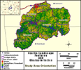 |
Total Ammonia Concentration Predictions (mg/L) (TAM_PRED) 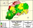 |
| Total Phosphorus Concentration Predictions (mg/L) (TP_PRED) 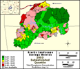 |
Escherichia coli Cell Count Predictions (bacterial cells/100 ml) (ECOLI_PRED) 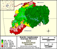 |
Landscape indicator maps have been produced by interpreting landscape-scale (i.e., broad-scale) ecological metrics among watersheds of the Upper White River, which are the first geospatial models of water-quality vulnerability in the Ozarks. The maps have been developed by using Partial Least Squares (PLS) analyses, a priori information about landscape conditions and the existing field water-quality monitoring data, remote sensing information, and water-quality data described in this browser. The PLS analyses were conducted at multiple geographic scales, from site-specific water quality measurements (fine-scale) to broader scale watershed analyses. The 244 subwatersheds represent the drainage area where water-quality measurements were conducted, and were used to increase the precision and accuracy of water-quality vulnerability predictions.
The results of PLS analyses provide watershed managers with the first broad-scale predictions that can be used to explain how land-cover type, land-cover configuration, environmental change, and human activities may affect the chemical and biological characteristics of surface water in the Upper White River region. The landscape factors that were used to conduct the PLS analyses are viewable in the Landscape Metrics - Analysis by Decade Status Maps and the Base Data Maps sections of the browser.
| *** For additional information on the Upper White River search project or to obtain an electronic copy of the complete datasets (maps) please contact Richard Steele at steele.richard@epa.gov / 702 798.2218 *** |