Basic Information
The principal focus of this project is the mapping and interpretation of landscape scale (i.e., broad scale) ecological metrics among contributing watersheds of the Upper White River, and the development of geospatial models of water-quality vulnerability for several suspected non-point source pollutants in the region. These analyses utilize a combination of existing field water-quality monitoring station data, remote sensing information, and a priori information about the ecological interactions between land-cover types and configuration (or more generally, landscape conditions), and water-quality in streams and rivers of the associated watershed.
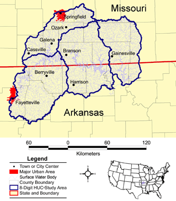
8-digit Hydrologic Unit Code (HUC) regions.
The analyses are conducted at multiple geographic scales, from the site-specific water-quality measurement (fine-scale) to the watershed analyses (broad-scale), which are reported to the user of this browser among 8-digit US Geological Service's hydrologic units (i.e., 8-digit HUCs) or among 244 subwatersheds, which are customized for this project. The 244 subwatersheds have been customized for this project in order to increase the precision and accuracy of the water-quality vulnerability predictions, and are based upon a single water-quality pour point for each subwatershed. The water-quality pour points are based upon the existence of Federal and State field-based water sampling locations, which have been extensively aggregated and quality checked specifically for this project.
Much is still unknown about how land-cover type, land-cover configuration, environmental change, and human activities may affect the chemical and biological characteristics of surface water of the Upper White River region. The information provided in this browser provides the first broad-scale predictions of water-quality vulnerability from chemical and biological constituents, and the distribution of potential drivers (i.e., land-cover types, land-cover configurations, and human activities) of water-quality conditions. We encourage the user to explore the water-quality vulnerability maps, the landscape metric maps - analysis by decade status, and the landscape metric change maps - analysis by decadal interval that were used to make the predictions to better understand how best to manage the watersheds of the Upper White River.
The landscape metrics that are mapped in this browser are used as indicators of surface water phosphorus, ammonia, and bacteria measurements, among the subwatersheds in the study area.
The indicator models (shown in this browser as maps) were developed by correlating field-based water-quality measurements and contemporaneous remote-sensing-based metrics, using multivariate statistical analyses:
The results of the three models mapped in this browser can be used by managers to prioritize and assess the relative vulnerability of surface water resources in the Ozarks, for example by identifying the predicted conditional state of a specific subwatershed as either:
(1) "most vulnerable", i.e., subwatersheds that have (predicted) high total phosphorus concentrations, high total ammonia concentrations, and high Escherichia coli cell counts
(2) "highly vulnerable", i.e., subwatersheds that have (predicted) low total phosphorus concentrations, high total ammonia concentrations, and high Escherichia coli cell counts
(3) "moderately vulnerable", i.e., subwatersheds that have (predicted) both moderate total phosphorus and total ammonia concentrations, and (predicted) moderate Escherichia coli cell counts.
(4) "least vulnerable", i.e., subwatersheds that have (predicted) low total phosphorus and total ammonia concentrations, but have moderate (predicted) Escherichia coli cell counts
Conditional states of subwatersheds are dependent upon the particular vulnerability criteria of the user, and it is not the intention of these results to specify such criteria. The results described in this browser provide watershed managers in the Ozark Mountains with a broad-scale vulnerability prediction tool, specifically focusing on total phosphorus, total ammonia, and Escherichia coli and are currently being used to prioritize and evaluate monitoring and restoration efforts for this major tributary, which is a major tributary to the Mississippi River and Gulf of Mexico.
Suggestions for Browser Usage:
Although every user will have their particular needs and interests, here are some suggestions for getting started,
step-by-step:
1. We suggest you briefly explore the Browser Content Guide to initially familiarize yourself with the large amount of information contained within this browser (Hint: you can always click the back button until you come back to this list of steps).
2. Look at the Water-Quality Vulnerability Indicator Maps, which provide you with a view of the relative vulnerability of watersheds in the study area, in terms of a few different water-quality characteristics.
3. Navigate to the Landscape Metric Maps - Analysis by Decade Status, which maps landscape metrics used to model the vulnerability results in step 2.
4. Navigate to the Landscape Metric Change Maps - Analysis by Decadal Interval, which maps key landscape metrics, over time, from step 3.
5. OK, it's time to navigate for yourself. Find the total phosphorus water-quality vulnerability model (a map). Hint: you can do this a couple of ways, following step 1 or step 2.
6. Once you find a map of interest, hover the cursor over a map for additional watershed information, click on a specific watershed to see its boundary and other information, including key metric information for multiple decades. Click on all of the buttons on the map page to provide you with additional information about how the mapped information was collected, calculated, and assessed and how the map information can be interpreted. Detailed technical information about the data used for a map is also provided (i.e., click on "metadata"). If you would like to "zoom in", copy, or print the map click on "detailed view"
7. When viewing maps of specific landscape metrics, we recommend that you refer to the Glossary & Important Terms to familiarize yourself with specific metrics, which are often abbreviated so that large amounts of information can be summarized in a single figure.
8. Finally, we strongly recommend that you take some time to fully explore the browser by clicking each link provided on the page. Several of the links take you to overview information about the concept of landscape ecology. The browser contains a tremendous amount of rich data and information about water-quality vulnerability in the Ozarks.
| *** For additional information on the Upper White River search project or to obtain an electronic copy of the complete datasets (maps) please contact Richard Steele at steele.richard@epa.gov / 702 798.2218 *** |