Landscape Metric Change Maps - Analysis by Decadal Interval (LMCM-ADI)
Click on Maps
You will need the free Adobe Reader
to view the "PDF Version" of the
maps contained within the web
pages of the following links.
See EPA's PDF page to learn more.
Study Area Orientation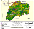 |
Land-Cover Percent Urban Change (PURBC) 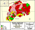 |
| Land-Cover Percent Forest Change (PFORC) 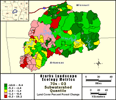 |
Land-Cover Percent Agriculture / Grassland Change (PAGTC) 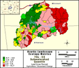 |
The Upper White River study area landscape metric maps provided in this section are based on the inter-decade change of conditions among the early 1970s, 1980s, 1990s, and 2000s (see maps and metadata for additional information). Land-cover maps demonstrate the changes in urban, forest, and agricultural/grassland land-cover types from the early 1970s to the early 1980s; from the early 1980s to the early 1990s; from the early 1990s to the early 2000s; and then a full 30 year summary of change from the early 1970s to the early 2000s. The three decadal views and the summary 30-year change view of land-cover change focuses on land-cover types, which are among the key indicators (using contemporaneous data in the late 1990s and early 2000s) of water-quality vulnerability. Additional analyses of land-cover change are ongoing to improve and expand upon the indicators of water-quality vulnerability provided in v2.0 of the browser.
- Overview of Key Land-Cover Types Used for Change Analyses
- Examples of urban land-cover are urban centers and small rural towns.
- Examples of the agricultural/grassland land-cover are pasture, a row crop field, a golf course, or any other area of herbaceous vegetation.
- Examples of forest land-cover are nature reserves and woodlots.
| *** For additional information on the Upper White River search project or to obtain an electronic copy of the complete datasets (maps) please contact Richard Steele at steele.richard@epa.gov / 702 798.2218 *** |