The principal focus of this project is the mapping and interpretation of landscape scale (i.e., broad scale) ecological metrics among contributing watersheds of the Upper White River, and the development of geospatial models of water-quality vulnerability for several suspected non-point source pollutants in the region.
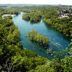
the controls on the flow of water to downstream
areas of the White River, provides hydroelectric
power to the public, and is one of the attractions
for visitors to nearby Branson, Missouri.
Basic Information: Complete overview of the projects focus, analysis, and findings.
Water-Quality Vulnerability Indicator Maps (WQVIM): Description and listing of indicator maps produced for this project.
Landscape Metric Maps - Analysis by Decade Status (LMM-ADS): Description and listing of landscape metric maps produced for this project.
Landscape Metric Change Maps - Analysis by Decadal Interval (LMCM-ADI): Description and listing of landscape metric change maps produced for this project.
Base Data Maps: Description and listing of base data maps utilized for this project.
Glossary & Important Terms: Complete list of important terms and acronym definitions.
| *** For additional information on the Upper White River search project or to obtain an electronic copy of the complete datasets (maps) please contact Richard Steele at steele.richard@epa.gov / 702 798.2218 *** |