EPA Response to BP Spill in the Gulf of Mexico
What EPA is doing
In response to the BP oil spill, EPA monitored air, water, sediment, and waste generated by the cleanup operations. Ongoing response and restoration efforts are posted to RestoreTheGulf.gov.
While emergency response data collection has ended, results continue to be available on this site. Any new data will continue to be posted to this site, and data will continue to be available here for the foreseeable future.
Much of the content of this site continues to be available for historical and information purposes, but we are no longer updating these pages on a regular basis.
EPA is one of many agencies providing support to the U.S. Coast Guard-led federal response to the BP oil spill. EPA is:
- collecting samples along the shoreline and beyond for chemicals related to oil and dispersants in the air, water and sediment;
- supporting and advising Coast Guard efforts to clean the reclaimed oil and waste from the shoreline; and
- closely monitoring the effects of dispersants in the subsurface environment.
EPA’s monitoring and sampling activities provide the Coast Guard, states, and local government with information about the potential impacts of the oil spill and response on human health of residents and aquatic life along the shoreline. The data EPA collects may be used to inform decisions by the Coast Guard, Food and Drug Administration (FDA), National Oceanic and Atmospheric Administration (NOAA), and state and local agencies among others, about seafood, habitat and beach closure issues. EPA continues to closely coordinate with other federal, state and local agencies.
EPA lists all dispersants that have been authorized for use on the National Contingency Plan (NCP) Product Schedule, which is a list of authorized dispersants and other chemicals that may be used to respond to oil discharges. As the lead federal agency for this spill response, the Coast Guard is responsible for approving the use of dispersant and the specific dispersant used from the NCP Product Schedule. EPA and the Coast Guard have required BP to implement a rigorous monitoring plan for use of these dispersants subsurface. EPA and NOAA review the results of this monitoring plan daily and make recommendations to Coast Guard as to whether the use of subsurface dispersant should continue.
Environmental data, including air quality and water samples, are posted and updated on EPA’s website as it is collected and validated. The data are meant to identify potential risks to public health and the environment.
More information on this page:- Real Time Air Quality
- EPA Sampling Plan for Air, Water, and Sediment
- More information about the government response
- National Response Team - Oil Spill Response Strategies for Coastal Marshes (PDF, 10 pp, 802 K, )
- Findings and Conclusions from the Alternative Coastal Protection and Clean-Up Technology Workshop (PDF, 4pp, 29K)
Information on other pages:
Air Monitoring on Gulf Coastline | Coastal Water Sampling | Coastal Sediment Sampling | Waste Management
You will need Adobe Reader to view some of the files on this page. See EPA's PDF page to learn more.
Real Time Air Quality
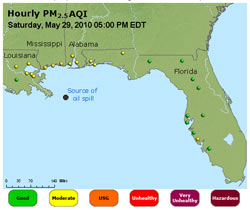
AIRNow Current Air Quality along the Gulf Coast
EPA has initiated an air monitoring effort to ensure the safety of local residents and track any developing air quality changes. Current air quality is shown with maps that are animated with color-coded pollutant concentrations according to the EPA’s Air Quality Index (AQI). The animated contour maps – much like radar images showing precipitation – display the hourly formation and movement of ozone or particulate pollution.
EPA Deploys Air Monitoring Aircraft to BP Spill
On April 28, 2010 EPA deployed the ASPECT, a twin engine aircraft designed to assist in the collection of air sampling data as well as photo documentation of environmental incidents.
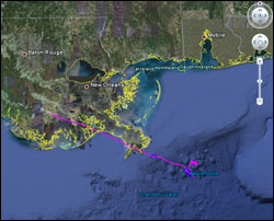
Screen shot of Google Earth showing ASPECT flight path.
Get ASPECT data in Google Earth.
This link will open the ASPECT data in your Google Earth browser. (You may have to save the KML file to your computer and then open it from there. Double click to launch the KML file; it opens Google Earth and shows the ASPECT data layer.)
If you don't have Google Earth installed you can get the free download here. ![]()
How to use ASPECT Google Earth data to find oil locations (PDF) (7 pp., 2.82MB)
General information about the ASPECT aircraft: slideshow | video ![]()
Read more about ASPECT, EPA's flying laboratory
Mobile Air Monitoring TAGA bus
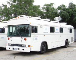
The TAGA bus analyzes the air along the Gulf Coast in response to the BP oil spill
EPA also has mobilized the Trace Atmospheric Gas Analyzers (TAGA), self-contained mobile laboratories that conduct real-time monitoring of outdoor air or emissions from various environmental sources.
See maps of the TAGA route along the Gulf Caoast and data from the buses.
More about deploying the TAGA bus during emergencies
EPA Sampling Plans for Air, Water, and Sediment
In partnership with state, local and federal agencies, EPA has implemented sampling and monitoring plans designed to look specifically for impacts of the spill on the coastal areas of Louisiana, Mississippi, Alabama and Florida and possibly Texas. The air plans are designed to assess the air quality during the in situ burns and assess whether contaminants from oil and dispersants were evaporating from the water column to the extent that they would impact air quality along the Gulf Coast. The water and sediment sampling plans are designed to assess the impacts to water and sediment quality as it relates to human health and the environment (including aquatic organisms) as the oil and dispersants migrate to and breach the shoreline. These plans are updated as necessary to reflect changing conditions.
EPA's Region 4 includes Alabama, Florida, Georgia, Kentucky, Mississippi, North Carolina, South Carolina, and Tennessee
EPA's Region 6 includes Arkansas, Louisiana, New Mexico, Oklahoma, and Texas
Sampling Plans (About PDF)
- Executive Summary (PDF) (25 K)
- EPA Region 6 Quality Assurance Sampling Plan to Evaluate the Effects to Water and Sediment from Oil and Dispersant to Shoreline, Nearshore and Far Off-Shore Areas (PDF) (795 K)
- Appendix A - Data Quality Objectives (PDF) (36 K)
- Appendix B - Standard Operating Procedures (PDF) (215 K)
- Appendix C - Sentinel Monitoring Stations - Latitude and Longitude (PDF) (43 K)
- Appendix D - EPA Water Quality Benchmarks (PDF) (16 K)
- Appendix E - Data Management Plan (PDF) (944 K)
- EPA Region 6 Assessment Boundary - Figure 3-1 (PDF) (114 K)
- EPA Region 6 Air Sampling and Monitoring Quality Assurance Sampling Plan (PDF) (869 K)
- EPA Region 4 Air Monitoring Quality Assurance Sampling Plan (PDF) (159 K)
- EPA Region 4 Gulf Coast Post-Oil Landfall Beach and Sediment Sampling Quality Assurance Project Plan for Mississippi, Alabama, and Florida (PDF) (342 K)
- EPA Region 4 Gulf Coast Bays Post Impact Water Quality Monitoring Quality Assurance Project Plan for Mississippi, Alabama, and Florida (275 K)
- EPA Region 4 Addendum to the water and sediment sampling plan (PDF) (27 K)
- EPA's Region 4 and 6 combined initial Quality Assurance Sampling Plan for BP Oil Spill (PDF) (162 K)
For more information about the government response to the BP oil spill:
Government Response
- RestoreTheGulf.gov: official federal government site for spill response and recovery
Other federal government information:
Connect with us:
Facebook: EPA
Twitter: EPA
Photos: BP Spill | more photos
Get email updates
 EPA data in Google Earth
Open the data (.kmz format)
- View EPA air, surface water, sediment and waste sampling locations in Google Earth.
Read more.