Pacific Southwest, Region 9
Serving: Arizona, California, Hawaii, Nevada, Pacific Islands, Tribal Nations
Naturally Occurring Asbestos
El Dorado Hills
Multimedia Exposure Assessment
Preliminary Assessment and Site Inspection Report Interim Final
Definitions
(in order used on this page)
U.S. EPA
U.S. Environmental Protection Agency
CERCLA
Comprehensive Environmental Response, Compensation, and Liability Act of 1980
SARA
Superfund Amendments and Reauthorization Act of 1986
E & E
Ecology and Environment, Inc.
START
Superfund Technical Assessment and Response Team
PA/SI
preliminary assessment/site inspection
HRS
U.S. EPA’s Hazard Ranking
NPL
National Priorities List
ultramafic
A type of igneous rock containing mainly dark, ferromagnesian minerals
ambient air
The surrounding air present throughout a inity
DTSC
California Department of Toxic Substances Control
CARB
California Air Resources Board
PA
preliminary assessment
CERCLIS
Comprehensive Environmental Response, Compensation, and Liability preliminary assessment Information System
CSD
El Dorado Hills Community Services District
CoEMD
El Dorado County Environmental Management Department
On this page
In October 2004, EPA Region 9's superfund collected more than 450 air and soil samples in community areas of El Dorado Hills. The EPA released the El Dorado Hills, Naturally Occurring Asbestos Multimedia Exposure Assessment ... (PDF) (163 pp, 1.3MB) outlining the extent of naturally occurring asbestos in the soil and air of El Dorado Hills, Calif.
1.0 Introduction
The U.S. Environmental Protection Agency (U.S. EPA), Region 9, under the authority of the Comprehensive Environmental Response, Compensation, and Liability Act of 1980 (CERCLA) and the Superfund Amendments and Reauthorization Act of 1986 (SARA), tasked the Ecology and Environment, Inc., (E & E) Superfund Technical Assessment and Response Team (START) to conduct a multimedia assessment of community areas and schools in El Dorado Hills in El Dorado County, California, to assess the potential for exposure from naturally occurring asbestos present in soils that have been disturbed. This preliminary assessment and site inspection (PA/SI) report identifies the subject area, describes the data-gathering activities that have been conducted to date, and summarizes the results of those activities.
As part of the PA/SI, the site is evaluated using U.S. EPA's Hazard Ranking System (HRS) criteria. The HRS assesses the relative threat associated with actual or potential releases of hazardous substances to the environment and has been adopted by the U.S. EPA to assist in setting priorities for further evaluation and eventual remedial action. The HRS is the primary method for determining a site's eligibility for placement on the National Priorities List (NPL). The NPL identifies sites where the U.S. EPA may conduct remedial response actions.
2.0 Apparent Problem
Exposure risk from naturally occurring asbestos, particularly an exposure occurring as a result of construction activities, has been a concern in El Dorado County for some time. (See Findings and Recommendations on Naturally-Occurring Asbestos to El Dorado County, State of California Asbestos Task Force, March 11, 1999.) Naturally occurring asbestos is found in ultramafic rock formations in many locations in El Dorado County, California. In El Dorado Hills, the location of this assessment, asbestos is found in association with the West Bear Mountains Fault Zone, which runs north to south across El Dorado County.
In El Dorado Hills the presence of asbestos in exposed soil and ambient air has already been documented through previous investigations as well as visual inspection conducted by the U.S. EPA, the California Department of Toxic Substances Control (DTSC), the California Air Resources Board (CARB), and the El Dorado Union High School District. These previous investigations were conducted in a residential area on Woedee Drive and at Oak Ridge High School, located at 1120 Harvard Way. Mitigation activities to address asbestos contamination in disturbed soils on the campus of Oak Ridge High School have been conducted by El Dorado Union High School District, with oversight by El Dorado County and the state and by U.S. EPA.
In September 2003, a citizen petitioned U.S. EPA to conduct a preliminary assessment at the El Dorado Hills Community Park, Silva Valley Elementary School, Rolling Hills Middle School, and other locations in the community where the suspected presence of naturally occurring asbestos in exposed and disturbed soil may be causing releases to air. After review of the petition and discussions with the petitioner, the U.S. EPA defined the study area (called El Dorado Hills Naturally Occurring Asbestos) to include the El Dorado Hills Community Park, Silva Valley Elementary School, Rolling Hills Middle School, Jackson Elementary School, and the New York Creek Nature Trail. The U.S. EPA entered the El Dorado Hills Naturally Occurring Asbestos site into the Comprehensive Environmental Response, Compensation, and Liability Information System (CERCLIS) with U.S. EPA Identification Number CAN000906083 on April 7, 2004.
3.0 Site Description and History
3.1 Site Location
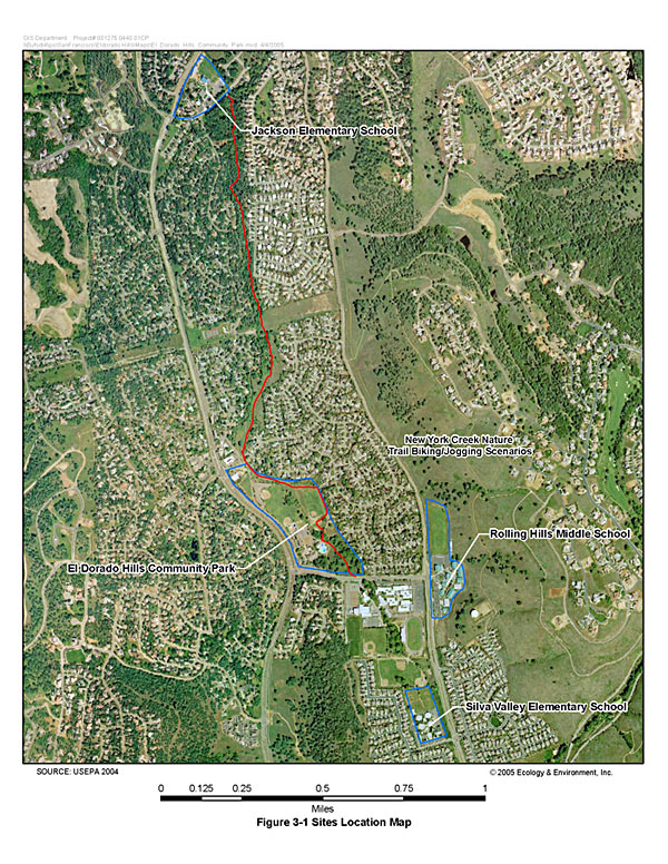
(Click for larger version)
El Dorado Hills is approximately 20 miles east of Sacramento, California. The community is within an unincorporated area of El Dorado County that is commonly referred to as the Western County Region. With a current population of about 31,000, El Dorado Hills has become a “bedroom” community, with a growing number of residents commuting to work in Sacramento.
A number of areas throughout El Dorado Hills are the subject of the El Dorado Hills Naturally Occurring Asbestos Multimedia Exposure Assessment. These areas, addressed in this PA/SI report and shown on Figure 3-1 (Sites Location Map), include the following:
- The El Dorado Hills Community Park, including several play areas and the New York Creek Nature Trail;
- Silva Valley Elementary School;
- Jackson Elementary School;
- Rolling Hills Middle School, including the dirt embankment inside the school’s eastern boundary (Dirt Embankment); and
- An unpaved lot used for parking on public property adjacent to and in front of Rolling Hills Middle School (Dirt Parking Area).
3.2 Site Description
El Dorado Hills Community Park and New York Creek Nature Trail. The El Dorado Hills Community Park at 1021 Harvard Way is situated on about 40 acres of property along El Dorado Hills Boulevard between Harvard Way and St. Andrews Drive (Latitude 38E 40' 59" North, Longitude 121E04' 28" West). The Community Park property, which is transected by New York Creek, contains three baseball diamonds, soccer playing fields, a children’s playground, a swimming pool, community center structures, the southern end of the New York Creek Nature Trail, other picnic and recreational areas, and parking areas. The New York Creek Nature Trail is an unpaved trail adjacent to New York Creek. From Harvard Way, the trail runs north almost 2 miles through the Community Park property and residential neighborhoods to Art Weisberg Park, which is opposite Jackson Elementary School on Francisco Drive.
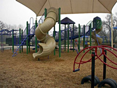
Silva Valley Elementary School. Silva Valley Elementary School is located at 3001 Golden Eagle Lane (Latitude 38E 40' 40" North, Longitude 121E04' 11" West). With about 650 students, it is a year-round K-5 elementary school in the Buckeye Union School District. Some of the school’s facilities include six classroom buildings, a multipurpose room, an administration building, a library, a computer laboratory, a grass-covered playing field, a grass-infield baseball diamond, a “Life Lab” garden area, and play structures.
Jackson Elementary School. Jackson Elementary School is located at 2561 Francisco Drive (Latitude 38E 42' 14" North, Longitude 121E04' 51" West). With almost 500 students, it is a traditional K-5 elementary school in the Rescue Union School District. Some of the school’s facilities include approximately 26 classrooms (all carpeted), an administration building, a library, a computer laboratory, a grass-covered playing field with grass-infield baseball diamonds, an outdoor classroom and garden, two paved play areas with basketball courts and tetherball, and play structures. The outdoor classroom and garden area is a place where students participate in gardening activities as part of the educational program.
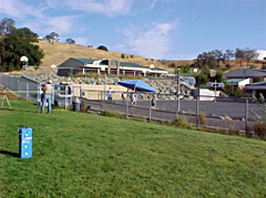
Rolling Hills Middle School and the Dirt Embankment. Rolling Hills Middle School is located at 7141 Silva Valley Parkway (Latitude 38E 40' 54" North, Longitude 121E04' 07" West). Built in its current location in 1998, the school is a year-round middle school (6th to 8th grades) with about 800 students. The school is part of the Buckeye Union School District. Some of the school’s facilities include classrooms, an administration building, a library, a grass-covered soccer field, and a paved basketball play area. The Dirt Embankment is a dirt embankment/hillside behind Rolling Hills Middle School and inside its eastern boundary.
The Dirt Parking Area. The Dirt Parking Area is an unpaved lot used for parking on public property in front of Rolling Hills Middle School, outside its western boundary. The property is said to be used regularly as a parking lot primarily by high school students who attend the nearby Oak Ridge High School.
3.3 Site History
On May 21, 1962, the El Dorado County Board of Supervisors adopted Resolution #98-62 creating the El Dorado Hills Community Services District (CSD). The CSD is governed by a five-member elected Board of Directors and is the primary provider of parks and recreation services to residents of El Dorado Hills, in addition to a variety of other community services.
The population of El Dorado Hills has grown rapidly in the last two decades. For example, the population jumped 81 percent in ten years, from an estimated 12,105 people in 1991 to 21,917 people in 2001. According to the State Department of Finance, by August 2001 the population was 23,013, and in January 2005 the population was about 31,000. Prior to this expansive growth, much of the land in the community was undeveloped open space.
The El Dorado Hills Community Park is one of almost two dozen neighborhood and community parks provided by the El Dorado Hills CSD. The CSD main office is at the Community Park, and there are about 26 full-time and 8 part-time workers on staff there year-round.
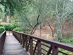
The southern end of the New York Creek Nature Trail begins in the Community Park, and the northern end is in Art Weisberg Park near Jackson Elementary School. The trail, which is considered an educational opportunity for local schools, provides botanical settings and views of native wildlife within the approximately 28acre New York Creek Nature Area.
El Dorado Hills CSD received part of the area that is now the New York Creek Nature Trail in 1972 as a gift deed. In 1986 the area was enlarged when an 11-acre parcel along New York Creek was conveyed to the CSD for use as an open space natural area. The New York Creek Stewardship Committee was formed to encourage local community involvement in the protection, conservation, care and use of New York Creek.
The Community Park grounds are maintained by both in-house and contracted maintenance workers who perform such duties as mowing lawns using a riding mower, grooming the baseball diamond infields using an electric maintenance cart (i.e., golf cart) and drag chains, and using a leaf blower to clear walkways and parking areas and to clean playground structures.
Silva Valley Elementary School and Rolling Hills Middle School are within the Buckeye Union School District. Built in 1992, Silva Valley Elementary School was once surrounded by empty fields, but new homes now flank the property. There are about 650 students currently enrolled at the year-round school, with about 29 teachers and 20 staff members, including maintenance staff. At Rolling Hills Middle School, which moved to its current permanent facilities in August 1998, there are about 800 students, 30 teachers, and 20 to 25 staff members, including maintenance staff. School district staff maintain the grounds at both schools, with the exception of mowing the playing fields, which is done by a contractor to the district.
The Dirt Parking Area, which sits adjacent to Rolling Hills Middle School, is apparently maintained by and under the jurisdiction of the El Dorado County Department of Transportation.
Jackson Elementary School, part of the Rescue Union School District, is a traditional elementary school. In the fall, there will be 22 teachers, about nine staff members, and about 470 students. The school grounds (along with the grounds of other schools in the district) are maintained by two district groundsmen; this number is expected to increase to three in June.
While Oak Ridge High School is not part of the El Dorado Hills Naturally Occurring Multimedia Assessment, it is centrally located between the majority of the locations that are included in the assessment, and it is in a geologically similar region. In February 2002, construction began of two soccer fields along the southwest border of Oak Ridge High School. During construction, veins of asbestos-bearing minerals were disturbed.
The El Dorado Union High School District reportedly encountered difficulties in acquiring reclaimed irrigation water for the project, so the soccer fields were left without landscaping for more than a year while a solution was sought. Subsequent erosion of disturbed, potentially asbestos-bearing soils from the unfinished fields caused by winter rains in 2002/2003 impacted classrooms and locker rooms downslope. In addition, the El Dorado Union High School District, in coordination with the El Dorado County Environmental Management Department (CoEMD) and DTSC, identified other areas of concern on the campus. This led the school district to undertake mitigation activities at Oak Ridge High School in the summer of 2003. See Section 4, Regulatory Involvement, for a brief discussion of activities subsequent to this mitigation effort.
| Region 9 NewsroomRegion 9 Programs | Grants & FundingUS-Mexico Border | Media CenterCareers | About Region 9A-Z Index |