Pacific Southwest, Region 9
Serving: Arizona, California, Hawaii, Nevada, Pacific Islands, Tribal Nations
Naturally Occurring Asbestos
El Dorado Hills
Multimedia Exposure Assessment
Preliminary Assessment and Site Inspection Report Interim Final
Definitions
(in order of use on this page)
- breathing height
A height representing a typical height of a person'e nose/mouth area - Level C personal protective equipment
Protective equipment to protect the body against contact with known or anticipated chemical hazards has been divided into four categories known as Levels A, B, C, and D. Level C generally includes the use of an air purifying respirator for inhalation protection.
5.0 Summary of Investigative Efforts (cont'd)
5.4 Air Sampling
-
5.4.1 Ambient Outdoor Air Sampling
-
5.4.2 Activity-Based Air Sampling
The START (Superfund Technical Assessment and Response Team) conducted ambient outdoor air sampling according to the El Dorado Hills Naturally Occurring Asbestos Multimedia Exposure Assessment, El Dorado Hills, California, Fixed Ambient Outdoor Reference Air Sampling Field Sampling Plan and the El Dorado Hills Naturally Occurring Asbestos Multimedia Exposure Assessment, El Dorado Hills, California, Activity-Based Outdoor Air Sampling of Community Park and Schools Field Sampling Plan.
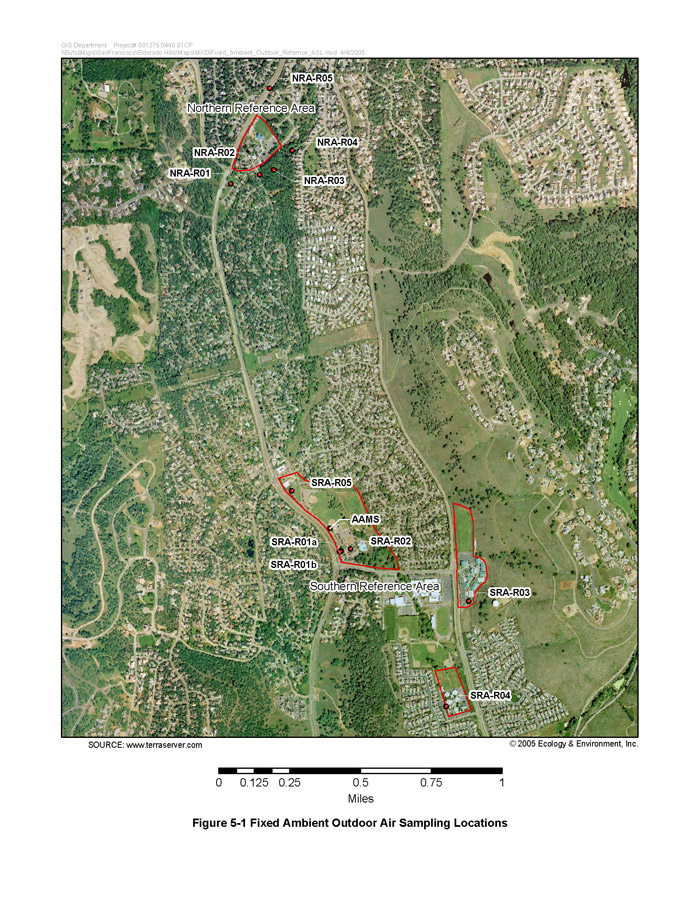
The START collected fixed ambient outdoor reference air samples from locations that were selected so as to collect from areas nearby but primarily outside of the influence of activity-based outdoor air sampling activities. These fixed ambient outdoor reference air sampling locations were in the following areas:
- Five locations, referred to as the Southern Reference Area, at the El Dorado Hills Community Park, Silva Valley Elementary School, and Rolling Hills Middle School, and
- Five locations, referred to as the Northern Reference Area, around Jackson Elementary School.
In addition to these reference air sampling locations, the START placed one fixed ambient outdoor air sampler co-located with a temporary meteorological station positioned in a secure location west of the children’s playground at the El Dorado Hills Community Park. This location is referred to as the Ambient Air Monitoring Station.
Finally, along the New York Creek Nature Trail, the START placed stationary air samplers to conduct ambient outdoor air monitoring on two days when there was public activity on the trail but no activity-based sampling conducted there.
Except for the Ambient Air Monitoring Station (which was enclosed by a cyclone fence), the air sample pumps used for ambient outdoor air sampling generally were in locations that had public access. To ensure the integrity of the samples, either a member of the sampling team or a security guard watched the air sample pumps while they were operating. The START also conducted regular checks throughout the day to make sure the pumps were operating and the power source was adequate and continuous.
5.4.1.1 Fixed Ambient Air Sampling at the Community Park
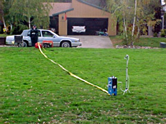
Beginning on September 27, several days prior to conducting activity-based outdoor air sampling, the START positioned and began operating a temporary meteorological station, a high-volume (i.e., high-flow, approximately 10 liters/minute) air sample pump, and a dust monitor within an existing small fenced area west of the children's playground at the El Dorado Hills Community Park. The location of this area is shown as the Ambient Air Meteorological Station (AAMS) on Figure 5-1 (Fixed Ambient Outdoor Air Sampling Locations). The START operated the meteorological station, the air sample pump, and the dust monitor at this location daily through October 12.
The meteorological station was set up as a base station for the project to monitor wind speed, wind direction, humidity, temperature, and other meteorological conditions. Due to equipment malfunction, the electronic set of data collected from the meteorological base station was lost for the period from October 5 through October 8, 2004; however the START did collect some of the meteorological data for this period through manual periodic logging. In addition, a second mobile meteorological station was used to collect meteorological data during some of the activity-based air sampling scenarios that were conducted during this period. The weather during the week leading up to the sampling was generally dry, and it was dry during most of the first week of sampling, but it drizzled on October 9, 2004. See Appendix A for a summary of meteorological data collected from the base station and from the mobile station.
(Click image for larger version)
The START collected air samples on air filters from the Ambient Air Meteorological Station fixed air sampler each day over an approximately 8-hour time interval. The daily time interval generally coincided with activity-based scenario sampling time periods. The primary focus of the investigative efforts is the potential for exposure of asbestos to children, so the intake of the air collection filter cassette at this location was positioned at a height of about 3 feet above the ground surface to represent the breathing height of a child. A summary of results for the ambient air samples from this monitoring station is shown in Table 5-1 (Ambient Air Monitoring Station Air Sample Summary Results).
5.4.1.2 Fixed Ambient Air Sampling for Activity-Based Reference Level Determinations
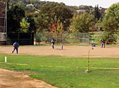
Southern Reference Area at the El Dorado Hills Community Park, Silva Valley Elementary School, and Rolling Hills Middle School One day prior to starting the activity-based outdoor air sampling at the El Dorado Hills Community Park, Silva Valley Elementary School, and Rolling Hills Middle School, the START positioned and began operating five high-flow air sample pumps at the park and the two schools. The five fixed ambient outdoor reference air sample locations, which are shown as the Southern Reference Area on Figure 5-1 (Fixed Ambient Outdoor Air Sampling Locations), are the following:
| SRA-R01 | Community Park, west of main office |
| SRA-R02 | Community Park courtyard between main office and pool area |
| SRA-R03 | Rolling Hills Middle School at the southern end of the campus |
| SRA-R04 | Silva Valley Elementary School at the southwestern corner of the campus |
| SRA-R05 | On Community Park property in open space west of the North Field baseball playing field |
| Sample ID | Date | PCME Structures (s/cc) | AHERA-like Total Structures (s/cc) |
Sensitivity (s/cc) |
| AAMS-D01-092704 | 9/27/04 | 0.00115 | 0.00172 | 0.000286 |
| AAMS-D02-092804 | 9/28/04 | <0.000872 | 0.00117 | 0.000292 |
| AAMS-D03-092904 | 9/29/04 | 0.000570 | 0.000570 | 0.000285 |
| AAMS-D04-093005 | 9/30/04 | 0.000860 | 0.00229 | 0.000287 |
| AAMS-D05-100104 | 10/01/04 | 0.00197 | 0.00282 | 0.000282 |
| AAMS-D06-100204 | 10/02/04 | 0.000582 | 0.00146 | 0.000291 |
| AAMS-D07-100304 | 10/03/04 | 0.000306 | 0.000611 | 0.000306 |
| AAMS-D107-100304 1 | 10/03/04 | 0.000613 | 0.00245 | 0.000307 |
| AAMS-D08-100404 | 10/04/04 | <0.000871 | <0.000871 | 0.000291 |
| AAMS-D09-100504 | 10/05/04 | results pending | results pending | results pending |
| AAMS-D10-100604 | 10/06/04 | results pending | results pending | results pending |
| AAMS-D11-100704 | 10/07/04 | 0.000580 | 0.00174 | 0.000290 |
| AAMS-D12-100804 | 10/08/04 | 0.000290 | 0.00232 | 0.000290 |
| AAMS-D13-100904 | 10/09/04 | <0.000851 | <0.000851 | 0.000285 |
| AAMS-D14-101004 | 10/10/04 | 0.000583 | 0.00612 | 0.000292 |
| AAMS-D15-101104 | 10/11/04 | <0.000894 | 0.00239 | 0.000299 |
| AAMS-D16-101204 | 10/12/04 | results pending | results pending | results pending |
| AAMS-1ZB-092904 2 | 9/29/04 | <0.000871 | <0.000871 | 0.000291 |
| AAMS-1ZB-100204 2 | 10/02/04 | <0.000871 | <0.000871 | 0.000291 |
| AAMS-2ZB-100204 2 | 10/02/04 | <0.000869 | <0.000869 | 0.000291 |
| AAMS-FB-093004 3 | 9/30/04 | <0.000974 | <0.000974 | 0.000326 |
|
PCME fibers = fibers longer than 5 microns with a width between 0.25 and 3 microns, and an aspect ratio (length to width) greater than 3:1 AHERA-like total structures = structures longer than 0.5 microns with an aspect ratio greater than 3:1 (Note this differs somewhat from the strict AHERA structure definition) Sensitivity = the sample-specific lowest concentration of asbestos the laboratory can reliably detects/cc = structures per cubic centimeter 1 AAMS-D107-100304 is a duplicate sample for (i.e., co-located with) AAMS-D07-100304 2 field blank sample 3 filter blank sample |
||||
Location SRA-R01 was originally sited close to El Dorado Hills Boulevard under the flag pole (SRA-R01a). The location was later changed (October 4, 2004) to a spot closer to the main office (SRA-R01b) due to problems obtaining electrical power to operate the air sample pump at that location and because park personnel wanted to remove the turf covering the driveway that passes through that area since it had become muddy and posed a hazard to drivers.
The START collected air samples on air filters from these fixed locations in the Southern Reference Area daily over an approximately 8-hour time interval one day prior to, each day during, and the day after the activity-based outdoor air sampling was conducted at the Community Park (including along the New York Creek Nature Trail) and the southern two schools. The daily time interval generally coincided with the activity-based scenario sampling time periods at the park and schools. The intakes of the air collection filter cassettes were positioned at a height of about 3 feet above the ground surface. This height was selected so as to be the same as that of the air collection filter cassette intakes that were used during activity-based sampling to represent the breathing height of a child. A dust monitor was co-located with the air sample pump at Rolling Hills Middle School at the southern end of the campus (SRA-R03), and total dust concentrations were monitored. The dust monitor was positioned at the same height as the air collection filter cassette. A summary of results for the Southern Reference Area samples is shown in Table 5-2 (Southern Reference Area Air Sample Summary Results). See Appendix B for a summary of the results from the dust monitor from these locations.
Northern Reference Area Around Jackson Elementary School
One day prior to conducting activity-based outdoor air sampling at Jackson Elementary School, the START positioned five high-flow air sample pumps at five locations in the vicinity of the school. The five fixed ambient outdoor reference air sample locations, which are shown as the Northern Reference Area on Figure 5-1 (Fixed Ambient Outdoor Air Sampling Locations), are the following:
| NRA-R01 | St. Andrews Park |
| NRA-R02 | Art Weisberg Park, on the east side of the park in a grassy area among the trees |
| NRA-R03 | Art Weisberg Park, on the west side of the park in an open grassy area next to Pendleton Drive |
| NRA-R04 | Adjacent to the walkway that joins the nearby residential neighborhood to the northern end of the New York Creek Nature Trail |
| NRA-R05 | On the median of El Dorado Hills Boulevard just north of Campbell Ranch Drive |
The START collected air samples on air filters from these fixed locations daily over an approximately 8-hour time interval one day prior to, the day of, and the day after the activity-based outdoor air sampling was conducted at Jackson Elementary School. The daily time interval generally coincided with the activity-based scenario sampling time periods at the school. The intakes of the air collection filter cassettes were positioned at a height of about 3 feet above the ground surface. This height was selected so as to be the same as that of the air collection filter cassette intakes that were used during activity-based sampling to represent the breathing height of a child. A dust monitor was co-located with the air sample pump at Art Weisberg Park, on the west side of the park in an open grassy area next to Pendleton Drive (NRA-R03), and total dust concentrations were monitored. The dust monitor was positioned at the same height as the air collection filter cassette. A summary of results for the Northern Reference Area samples is shown in Table 5-3 (Northern Reference Area Air Sample Summary Results). See Appendix B for a summary of the results from the dust monitor from these locations.
|
Table 5-2 Southern Reference Area Air Sample Summary Results |
||||||
| Sample ID | Location | Location Description | Date | PCME Structures (s/cc) |
AHERA-like Total Structures (s/cc) |
Sensitivity (s/cc) |
| SRA-R01-100104 | SRA-R01 | Community Park, west of main office | 10/01/04 | 0.000859 | 0.00229 | 0.000286 |
| SRA-R02-100104 | SRA-R02 | Community Park courtyard between main office and pool area | 10/01/04 | 0.00198 | 0.00368 | 0.000283 |
| SRA-R03-100104 | SRA-R03 | Rolling Hills Middle School at the southern end of the campus | 10/01/04 | 0.000269 | 0.00188 | 0.000269 |
| SRA-R04-100104 | SRA-R04 | Silva Valley Elementary School at the southwestern corner of the campus | 10/01/04 | 0.000870 | 0.00377 | 0.000290 |
| SRA-R05-100104 | SRA-R05 | On Community Park property in open space west of the North Field baseball playing field | 10/01/04 | 0.00113 | 0.00113 | 0.000283 |
| SRA-R01-100204 | SRA-R01 | Community Park, west of main office | 10/02/04 | 0.000289 | 0.00375 | 0.000289 |
| SRA-R101-100204 | SRA-R01 | Community Park, west of main office | 10/02/04 | <0.000853 | 0.000856 | 0.000285 |
| SRA-R02-100204 | SRA-R02 | Community Park courtyard between main office and pool area | 10/02/04 | 0.000570 | 0.00256 | 0.000285 |
| SRA-R03-100204 | SRA-R03 | Rolling Hills Middle School at the southern end of the campus | 10/02/04 | 0.000287 | 0.00115 | 0.000287 |
| SRA-R04-100204 | SRA-R04 | Silva Valley Elementary School at the southwestern corner of the campus | 10/02/04 | 0.000583 | 0.00204 | 0.000292 |
| SRA-R05-100204 | SRA-R05 | On Community Park property in open space west of the North Field baseball playing field | 10/02/04 | 0.000582 | 0.00233 | 0.000291 |
| SRA-R01-100304 | SRA-R01 | Community Park, west of main office | 10/03/04 | <0.000895 | 0.00180 | 0.000299 |
| SRA-R02-100304 | SRA-R02 | Community Park courtyard between main office and pool area | 10/03/04 | <0.000894 | 0.000897 | 0.000299 |
| SRA-R03-100304 | SRA-R03 | Rolling Hills Middle School at the southern end of the campus | 10/03/04 | <0.000840 | 0.000281 | 0.000281 |
| SRA-R04-100304 | SRA-R04 | Silva Valley Elementary School at the southwestern corner of the campus | 10/03/04 | 0.000584 | 0.00234 | 0.000292 |
| SRA-R05-100304 | SRA-R05 | On Community Park property in open space west of the North Field baseball playing field | 10/03/04 | <0.000891 | 0.000894 | 0.000298 |
| SRA-R01-100404 | SRA-R01 | Community Park, west of main office | 10/04/04 | <0.000882 | 0.000885 | 0.000295 |
| SRA-R02-100404 | SRA-R02 | Community Park courtyard between main office and pool area | 10/04/04 | 0.000589 | 0.00118 | 0.000294 |
| SRA-R03-100404 | SRA-R03 | Rolling Hills Middle School at the southern end of the campus | 10/04/04 | <0.000894 | 0.000897 | 0.000299 |
| SRA-R04-100404 | SRA-R04 | Silva Valley Elementary School at the southwestern corner of the campus | 10/04/04 | 0.000290 | 0.00290 | 0.000290 |
| SRA-R05-100404 | SRA-R05 | On Community Park property in open space west of the North Field baseball playing field | 10/04/04 | <0.000888 | 0.000891 | 0.000297 |
| SRA-R01-100504 | SRA-R01 | Community Park, west of main office | 10/05/04 | 0.000889 | 0.00356 | 0.000296 |
| SRA-R02-100504 | SRA-R02 | Community Park courtyard between main office and pool area | 10/05/04 | 0.000585 | 0.00205 | 0.000292 |
| SRA-R103-100504 | SRA-R03 | Rolling Hills Middle School at the southern end of the campus | 10/05/04 | 0.000863 | 0.00259 | 0.000288 |
| SRA-R03-100504 | SRA-R03 | Rolling Hills Middle School at the southern end of the campus | 10/05/04 | 0.000289 | 0.00173 | 0.000289 |
| SRA-R04-100504 | SRA-R04 | Silva Valley Elementary School at the southwestern corner of the campus | 10/05/04 | <0.000888 | 0.00267 | 0.000297 |
| SRA-R05-100504 | SRA-R05 | On Community Park property in open space west of the North Field baseball playing field | 10/05/04 | 0.000291 | 0.00204 | 0.000291 |
| SRA-R01-100604 | SRA-R01 | Community Park, west of main office | 10/06/04 | 0.00440 | 0.00586 | 0.000293 |
| SRA-R02-100604 | SRA-R02 | Community Park courtyard between main office and pool area | 10/06/04 | <0.000851 | 0.00285 | 0.000285 |
| SRA-R102-100604 | SRA-R02 | Community Park courtyard between main office and pool area | 10/06/04 | 0.00115 | 0.00288 | 0.000288 |
| SRA-R03-100604 | SRA-R03 | Rolling Hills Middle School at the southern end of the campus | 10/06/04 | 0.00145 | 0.00347 | 0.000290 |
| SRA-R04-100604 | SRA-R04 | Silva Valley Elementary School at the southwestern corner of the campus | 10/06/04 | 0.000907 | 0.00574 | 0.000302 |
| SRA-R05-100604 | SRA-R05 | On Community Park property in open space west of the North Field baseball playing field | 10/06/04 | 0.00177 | 0.00325 | 0.000296 |
| SRA-R01-100704 | SRA-R01 | Community Park, west of main office | 10/07/04 | results pending | results pending | results pending |
| SRA-R02-100704 | SRA-R02 | Community Park courtyard between main office and pool area | 10/07/04 | 0.000575 | 0.00402 | 0.000287 |
| SRA-R03-100704 | SRA-R03 | Rolling Hills Middle School at the southern end of the campus | 10/07/04 | <0.000844 | 0.000282 | 0.000282 |
| SRA-R04-100704 | SRA-R04 | Silva Valley Elementary School at the southwestern corner of the campus | 10/07/04 | 0.000866 | 0.00115 | 0.000289 |
| SRA-R05-100704 | SRA-R05 | On Community Park property in open space west of the North Field baseball playing field | 10/07/04 | 0.000285 | 0.000856 | 0.000285 |
| SRA-R01-100804 | SRA-R01 | Community Park, west of main office | 10/08/04 | <0.000883 | 0.00118 | 0.000295 |
| SRA-R02-100804 | SRA-R02 | Community Park courtyard between main office and pool area | 10/08/04 | 0.000577 | 0.00289 | 0.000289 |
| SRA-R03-100804 | SRA-R03 | Rolling Hills Middle School at the southern end of the campus | 10/08/04 | <0.000883 | 0.000590 | 0.000295 |
| SRA-R103-100804 | SRA-R03 | Rolling Hills Middle School at the southern end of the campus | 10/08/04 | 0.000295 | 0.00412 | 0.000295 |
| SRA-R04-100804 | SRA-R04 | Silva Valley Elementary School at the southwestern corner of the campus | 10/08/04 | 0.000564 | 0.00169 | 0.000282 |
| SRA-R05-100804 | SRA-R05 | On Community Park property in open space west of the North Field baseball playing field | 10/08/04 | 0.000877 | 0.00205 | 0.000292 |
| SRA-1ZB-100804 | field blank | field blank | 10/08/04 | <0.000853 | <0.000853 | 0.000285 |
| SRA-2ZB-100804 | field blank | field blank | 10/08/04 | <0.000846 | <0.000846 | 0.000283 |
|
PCME fibers = fibers longer than 5 microns with a width between 0.25 and 3 microns, and an aspect ratio (length to width) greater than 3:1 AHERA-like total structures = structures longer than 0.5 microns with an aspect ratio greater than 3:1 (Note this differs somewhat from the strict AHERA structure definition) Sensitivity = the sample-specific lowest concentration of asbestos the laboratory can reliably detect s/cc = structures per cubic centimeter |
||||||
(click image for larger version)
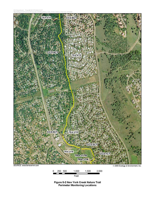
5.4.1.3 Perimeter Monitoring on the New York Creek Nature Trail
On October 3 and October 9, 2004, the START placed five high-flow air sample pumps along the New York Creek Nature Trail to collect ambient outdoor air samples during those two days. The START was not conducting activity-based air sampling in the immediate vicinity on those two days, but members of the public were active in the park and on the trail. On October 3, a dog-walk event was held in the park, and on October 9 the trail was open to normal activity for a Saturday.
The locations of the five stationary sample pumps that were operated on the trail on October 3 are shown as CC2-1CT, CC2-2CT, CC2-3CT, CC2-4CT, and CC2-5CT, and the locations of the five sample pumps that operated on October 9 are shown as TRA-1TR/TRA11TR, TRA-2TR, TRA-3TR, TRA-4TR, and TRA-5TR on Figure 5-2 (New York Creek Nature Trail Perimeter Monitoring Locations). The START collected air samples on air filters from these stationary locations over an approximately 8-hour time interval on these two days. The intakes of the air collection filter cassettes in stationary locations along the trail were positioned at a height of about 5 feet above the ground surface to represent the breathing height of an adult. A summary of results for the trail perimeter samples is shown in Table 5-4 (New York Creek Nature Trail Perimeter Monitoring Air Sample Summary Results).
Dust monitors were co-located with two of the air sample pumps (CC2-1CT and CC2-3CT) on October 3 and with all five air sample pumps on October 9. These dust monitors measured total dust concentrations along the trail. The dust monitors were positioned at the same height as the air collection filter cassettes. See Appendix B for a summary of the results from the dust monitor from these locations.
| Region 9 NewsroomRegion 9 Programs | Grants & FundingUS-Mexico Border | Media CenterCareers | About Region 9A-Z Index |