Waste Site Cleanup & Reuse in New England
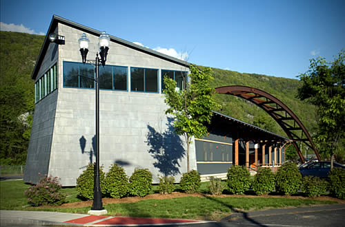
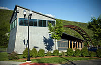
Waypoint Visitor's Center - Bellows Falls, VT
(June 2006)
Program: EPA
Assessment Grant
Grant Recipient: Windham
Regional Commission (contacts)
Summary: A former rail yard becomes a Connecticut
River Byway Waypoint Visitors Center, incorporating in its design
an echo of a steel arch bridge from the past.
The Connecticut River was the first major river in the country to be improved for travel. In order to allow passage around the narrow and the highest waterfall on the river, Bellows Falls Canal Co. was formed in 1791, the first canal company chartered in the country. The canal provided power to mills and allowed lumber and barges to bypass the gorge by a series of nine locks. In the mid-1850s, railroads replaced the river as the prime means of transport, and in 1898 a utility began to use the canal water to generate electricity. Such use continues today.
Bellows Falls was also the site of the first bridge across the Connecticut River anywhere along its 410-mile length. But it was a later bridge, called the “Arch Bridge”, which more recently captivated the population's loyalty.
|
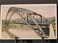
The steel “Arch Bridge” was the longest suspension bridge in North America at the time of its construction in 1906. It spanned the Connecticut River between Bellows Falls and North Walpole, NH. The bridge closed in 1971 due to safety concerns. When it was demolished in 1982 to be replaced by the current steel girder bridge, it was made even more memorable by its refusal to fall after five attempts to blast it down. It was eventually cut down by torches. That is the old arch bridge which still lives on the hearts of area residents.
Bellows Falls went through a period without growth or major change. Then, in 1996, the states of MA, NH and VT received funding from the FHA's Scenic Byway Program to study the feasibility of developing a Byway along the Connecticut River. Working with the towns along each side of the river, the regional commissions inventoried the historic, cultural, scenic, recreational, and natural resources of the entire Connecticut River Valley, from Holyoke, MA to the northern-most reaches in Pittsburgh, NH. The “Waypoint” communities would be crossroads communities which could offer amenities such as lodging, restaurants, and other activities and sites in the region. In 1999, the village of Bellows Falls was chosen as the “Waypoint” community for an area that includes the towns of Rockingham, Westminster, Putney, and Springfield, VT, and Charlestown and Walpole, NH. Other centers are located every 25 to 35 miles along the river. The purpose of the Byway was to get people off the interstate and instead to explore the Valley's back roads.
A site in Bellows Falls across from the railroad station was chosen, and it was a brownfields site. Using a portion of a $350,000 EPA Brownfields Assessment Grant, the Windham Regional Commission performed environmental site assessment and monitoring to complete work necessary prior to redevelopment. The assessment and monitoring work for this project cost about $30,000, and was performed by ATC out of their Richmond, VT office. Site monitoring found that levels of Tetrachloromethane (TCE) in groundwater exceeded VT Groundwater Enforcement Standards. This prompted the state to request a year of groundwater monitoring and sampling to monitor groundwater conditions. Following one year of monitoring, results showed that no further action was required.
|
|||
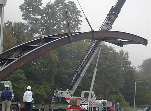
Meetings began in 2000 to plan for the design of the Bellows Falls Visitors Center. The award-winning design represents a train locomotive and railroad station canopy with the building passing under an arch evocative of the old arch bridge. Groundbreaking for the Center was in July 2002. In September 2002 a major milestone for the community occurred when a 145-foot replica of the “Arch” returned to Bellows Falls as part of the overall new building design. The finished Interpretive Center is in a unique location to provide the visitor a window to the past and a jumping off point to explore the Connecticut River Valley.
|
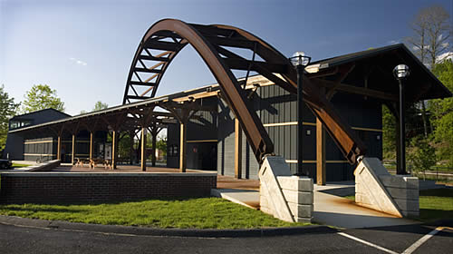
The Bellows Falls Visitors Center is now open to the public. The building is also home to the Great Falls Regional Chamber of Commerce. The total redevelopment costs were more than $1.26 million, and sources of funding for the construction of the facility included grants from the Federal Highways Scenic Byway Program, Housing Vermont, Vermont Agency of the Transportation Enhancement Grants, the Windham Foundation, the Connecticut River Joint Commissions Partnership program, and the Southern Vermont Regional Marketing Organization.
Timeline:
-
1785: Construction of the first bridge anywhere across the Connecticut River, From Bellows Falls to Walpole, NH.
-
1906: Construction of the “Arch Bridge”, the longest suspension bridge in North America at the time, with one span at 540 feet, across the Connecticut River to North Walpole, NH.
-
1971: Closure of the “Arch Bridge” due to safety concerns.
-
1982: Demolition of the “Arch Bridge” for replacement by a newer bridge.
-
Jul 2002: Groundbreaking for the center.
-
Sep 2002: Arrival of the new 145-foot replica steel arch, representing the “old arch bridge”.
-
2003: Opening of the new center.
-
May 2004: The project's builder, Baybutt Construction, received the AIA's Merit Award for Excellence in Architecture. Designer: Daniel V. Scully Architects.