Waste Site Cleanup & Reuse in New England
Transforming a Brownfields Industrial site into Affordable Housing in Olneyville-Narragansett Landing
Success in EPA Brownfields Assessment Demonstration Pilot Program
City of Providence , Rhode Island
(September 7, 2005)
Contacts
|
|||||
Creating a New Neighborhood
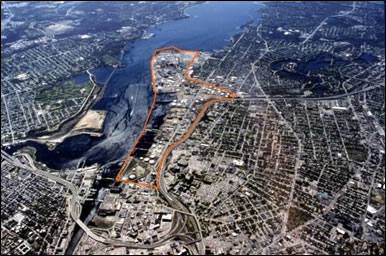
Narragansett Landing is a 280-acre site along Providence River currently occupied by industrial uses, including bulk fuel storage, shipbuilding, and sewage treatment. By the late 1990's, city officials had recognized that these uses were outmoded and that the land should be redeveloped.
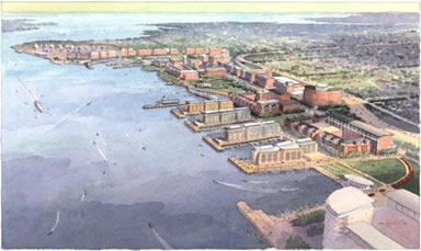
A plan developed by the city in 2000 called for Narragansett Landing to be transformed into a completely new neighborhood: a mixed-use district that would include housing, office buildings and a series of waterfront parks. This ambitious plan acknowledged that there was a considerable amount of contaminated land, owing to over a century of industrial uses. This land would have to be assessed and cleaned up for the plan to become a reality.
In an effort to evaluate the extent of the environmental contamination of the study area, the city applied to the Environmental Protection Agency for funding under the Brownfields Assessment Demonstration Pilot program. In May of 2000, the city was awarded $250,000 to conduct environmental assessments at this site. Physical sampling was conducted during the summer of 2002 by GZA GeoEnvironmental, Inc., under contract with the City. GZA's report, prepared in early 2003, revealed that least 20 percent of the parcels of land have had releases of hazardous material or oil.
Assessment of contamination in Narragansett Landing has been critical to moving forward with redevelopment. This is an area with very difficult obstacles to redevelopment: much of it lies in the floodplain, with many businesses that would have to be relocated, compounded by the presence of environmental contamination. Completion of this assessment has given the city and prospective developers important information that will make redevelopment a less risky prospect.
Revitalizing a Distressed Neighborhood
Upstream from Narragansett Landing along the Woonasquatucket River is Olneyville, perhaps the most distressed neighborhood in Providence. It shares with Narragansett Landing considerable environmental blight owing to its past industrial uses. It is also suffering from a housing crunch as home prices have skyrocketed in the past several years. The City has recently been focusing resources to revitalize Olneyville by developing green space, improving the public infrastructure, and encouraging development of market-rate and affordable housing. Towards this end, the City used $80,000 of the EPA grant to conduct an environmental assessment at three city-owned parcels of formerly industrial land in Olneyville. These sites were chosen for their strategic location adjacent to the Riverside Mills brownfield site. Riverside Mills is being cleaned up and transformed into Riverside Park, one of several parks connected by the Woonasquatucket River Greenway. Funding for the redevelopment of the park was secured through Providence's designation as a Brownfields Showcase Community. For the park to be successful the city's plan calls for housing nearby. As such, the three parcels chosen for assessment, along with several other vacant lots in the vicinity, have been designated for housing.
The City had GZA conduct Phase I and Phase II environmental assessments of the three Olneyville lots in 2004. The assessment of the site revealed concentrations of metals, PAHs and TPHs that exceed state limits. The investigation also discovered a 10,000-gallon underground storage tank. The City designated the Olneyville Housing Corporation (OHC) as developer for the parcels. Providence's planning department worked closely with OHC and GZA to develop a site plan and a remedial action work plan to assure that redevelopment of the site eliminates environmental risk to its future inhabitants. The resulting plan calls for more than 20 units of affordable housing on the site, featuring panoramic views of the river and the new park.
The Brownfields Assessment grant enabled the city and the Olneyville Housing Corporation (OHC) to leverage $200,000 in environmental cleanup funding, and nearly $4,000,000 in grants and low-interest loans for affordable housing development. Further, Providence's planning department has guided OHC through an expedited site plan review process before the planning commission. This will enable the corporation to break ground in the spring, with an anticipated move-in date of early 2006.
Providence is the second largest city in New England with a population of 173,618. The majority of the City's population is minority for the first time, with ten neighborhoods comprising more than 60% minority populations. Olneyville, the target area, is 0.55 square miles. The population is comprised of 2,228 households, consisting of: 57.4% Hispanic, 22.0% White, 10.0% Black/African American, 7.1% Asian or Pacific Islander, and 0.9% Native American, with 41% families below the poverty level.