ReefLink Database

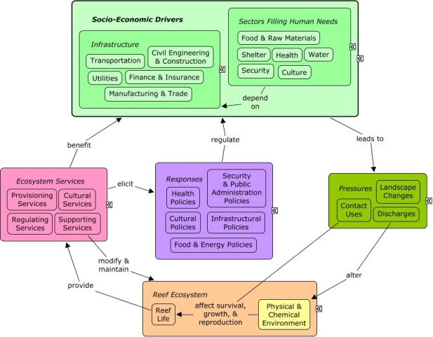
Infrastructure
Infrastructural sectors provide the physical, organizational, and technical support for the economy to function, including construction, utilities, transportation, finance, manufacturing, wholesale and retail trade, and technical services.
CMap
CMap Description
Socio-economic drivers result in human activities that may intentionally or unintentionally exert pressures on the environment, and lead to changes in the state of the reef ecosystem, including the physical and chemical environment and reef life. Changes in the quality and functioning of the reef ecosystem have an impact on the provision of ecosystem services, which directly or indirectly benefit human well-being by fulfilling many human needs. The drivers that benefit from the ecosystem services may, or may not be the same drivers that exert pressures on the reef ecosystem. Humans make decisions in response to the impacts on ecosystem services or their perceived value. Responses may seek to control socio-economic drivers through policies or economic decisions that directly influence sectors.Citations
| Citation | Year | Study Location | Study Type | Database Topics |
|---|---|---|---|---|
| Waite, R., E. Cooper, N. Zenny, and L. Burke. 2011. Coastal Capital: Jamaica - The Economic Value of Jamaica�s Coral Reef-Related Fisheries. Working Paper, World Resources Institute and The Nature Conservancy, Washington, D. C. (USA). | 2011 | Global; Jamaica | Decision Support Frameworks & Tools | Beaches & Nature Parks; Climate; Coastal Development; Cultural Policies; Cultural Protections; Finfish Harvest; Fish; Fishing & Harvesting Management; Fishing Sector; Hotel & Food Services; Mangroves; Monetary Valuation; Ocean Acidity; Seagrasses; Sediment; Shoreline Protection; Storms & Hurricanes; Tourism & Recreation; Tourism & Recreation Policies; Valuation; Wholesale & Retail Trade |
| Bainbridge, S; Eggeling, D; Page, G. 2011. Lessons from the Field-Two Years of Deploying Operational Wireless Sensor Networks on the Great Barrier Reef. Sensors 11:6842-6855. | 2011 | Australia | Field Study & Monitoring | Metals, Electronics, & Machinery Products |
| Dick, DM; Hines, EM. 2011. Using distance sampling techniques to estimate bottlenose dolphin (Tursiops truncatus) abundance at Turneffe Atoll, Belize. Marine Mammal Science 27:606-621. | 2011 | South & Central America; Belize | Finfish Harvest; Fishing Sector; Marine Protected Areas; Ports & Harbors; Whales & Dolphins | |
| Hill, M; Allenby, A; Ramsby, B; Schonberg, C; Hill, A. 2011. Symbiodinium diversity among host clionaid sponges from Caribbean and Pacific reefs: Evidence of heteroplasmy and putative host-specific symbiont lineages. Molecular Phylogenetics and Evolution 59:81-88. | 2011 | Global; South & Central America; Florida; US Pacific & Hawaii; Caribbean | Boring Sponges; Ports & Harbors; Sponges; Stony Coral; Zooxanthellae | |
| Bostrom, C; Pittman, SJ; Simenstad, C; Kneib, RT. 2011. Seascape ecology of coastal biogenic habitats: advances, gaps, and challenges. Marine Ecology Progress Series 427:191-217. | 2011 | South & Central America; Mexico | Review; Field Study & Monitoring | Docks & Marinas; Fish; Lobster, Crab, & Shrimp; Mangroves; Seagrasses; Shoreline Protection |
| Fitzpatrick, R; Abrantes, KG; Seymour, J; Barnett, A. 2011. Variation in depth of whitetip reef sharks: does provisioning ecotourism change their behaviour? Coral Reefs 30:569-577. | 2011 | Australia; Fiji | Apex Fish Predators; Dive, Snorkeling, & Swimming Tourism; Small Boats; Tourism & Recreation | |
| Hamilton, RJ; Potuku, T; Montambault, JR. 2011. Community-based conservation results in the recovery of reef fish spawning aggregations in the Coral Triangle. Biological Conservation 144:1850-1858. | 2011 | Micronesia; Papua New Guinea; Philippines | Field Study & Monitoring | Finfish Harvest; Fish; Fishing Sector; Marine Protected Areas; Piscivorous Fish; Wholesale & Retail Trade |
| Hein, CJ; FitzGerald, DM; Milne, GA; Bard, K; Fattovich, R. 2011. Evolution of a Pharaonic harbor on the Red Sea: Implications for coastal response to changes in sea level and climate. Geology 39:687-690. | 2011 | Global; Egypt | Field Study & Monitoring | Climate; Ports & Harbors; Sediment; Water Depth & Sea Level |
| Thurber, RLV; Correa, AMS. 2011. Viruses of reef-building scleractinian corals. Journal of Experimental Marine Biology and Ecology 408:102-113. | 2011 | Global; Florida | Review; Model | Algae; Hydrocoral; Microorganisms; Pathogens; Ports & Harbors; Stony Coral |
| Jayaraju, N; Reddy, BCSR; Reddy, KR. 2011. Anthropogenic impact on Andaman coast monitoring with benthic foraminifera, Andaman Sea, India. Environmental Earth Sciences 62:821-829. | 2011 | India | Field Study & Monitoring | Aquaculture; Environmental Monitoring, Mapping, & Scientific Research; Finfish Harvest; Sediment; Shipping, Storage, & Warehousing; Tourism & Recreation; Waterborne Discharges |
| Terrados, J; Ramirez-Garcia, P. 2011. Cover and edge length to area ratio of seagrass (Thalassia testudinum) meadows in coral reef lagoons (Veracruz Reef System, Southwest Gulf of Mexico). Aquatic Conservation: Marine and Freshwater Ecosystems 21:224-230. | 2011 | South & Central America; Australia; US East Coast (NC, SC, GA); Mexico | GIS & Maps | Docks & Marinas; Seagrasses |
| Biggs, D. 2011. Understanding Resilience in a Vulnerable Industry: the Case of Reef Tourism in Australia. Ecology and Society 16. | 2011 | Global; Australia | Banks, Credit, & Securities; Climate; Tourism & Recreation | |
| Lerman, A; Guidry, M; Andersson, AJ; Mackenzie, FT. 2011. Coastal Ocean Last Glacial Maximum to 2100 CO(2)-Carbonic Acid-Carbonate System: A Modeling Approach. Aquatic Geochemistry 17:749-773. | 2011 | Global | Model | CO2; Ocean Acidity; Sediment; Surface & Groundwater Flow; Water Depth & Sea Level |
| Peresypkin, VI; Smurov, AV; Shulga, NA; Safonova, ES; Smurova, TG; Bang, CV. 2011. Composition of the Organic Matter of the Water, Suspended Matter, and Bottom Sediments in Nha Trang Bay in Vietnam in the South China Sea. Oceanology 51:959-968. | 2011 | China; Vietnam | Nutrients; Sediment; Solid Waste Disposal; Surface & Groundwater Flow | |
| Armoza-Zvuloni, R; Segal, R; Kramarsky-Winter, E; Loya, Y. 2011. Repeated bleaching events may result in high tolerance and notable gametogenesis in stony corals: Oculina patagonica as a model. Marine Ecology Progress Series 426:149-159. | 2011 | Model | Climate; Stony Coral | |
| Eme, J; Dabruzzi, TF; Bennett, WA. 2011. Thermal responses of juvenile squaretail mullet (Liza vaigiensis) and juvenile crescent terapon (Terapon jarbua) acclimated at near-lethal temperatures, and the implications for climate change. Journal of Experimental Marine Biology and Ecology 399:35-38. | 2011 | Indonesia | Fish; Mangroves; Sea Temperatures; Seagrasses; Wholesale & Retail Trade | |
| Navalgund, RR; Singh, RP. 2011. Climate Change Studies Using Space Based Observation. Journal of the Indian Society of Remote Sensing 39:281-295. | 2011 | Global; India | Review; Field Study & Monitoring; Model; Index or Indicator; GIS & Maps | Climate; Deforestation & Devegetation; Environmental Monitoring, Mapping, & Scientific Research; Forestry; Greenhouse Gas Emissions; Housing; Irrigation; Light; Salinity; Water Depth & Sea Level; Wetlands |
| Ban, NC; Adams, V; Pressey, RL; Hicks, J. 2011. Promise and problems for estimating management costs of marine protected areas. Conservation Letters 4:241-252. | 2011 | Global; Australia | Model | Banks, Credit, & Securities; Marine Protected Areas |
| Natural Resources Conservation Service. 2011. National Handbook of Conservation Practices. U.S. Department of Agriculture. | 2011 | Field Study & Monitoring | Agriculture; Aquaculture; Bivalves; Discharges; Fish; Irrigation; Landscape Conservation & Restoration; Non-point Source Runoff; Nutrients; Pipelines; Salinity; Sediment; Shoreline Protection; Surface & Groundwater Flow; Tourism & Recreation; Transportation Policies; Waste Management; Wetland & Reef Restoration; Wetlands | |
| Natural Resources Conservation Service. 2011. Conservation Practice Standard: Bivalve Aquaculture Gear and Biofouling Control. CODE 400, USDA. | 2011 | Aquaculture; Bivalves; Invasive Species; Ports & Harbors; Sediment; Storms & Hurricanes; Substrate | ||
| Schmitt, S; Deines, P; Behnam, F; Wagner, M; Taylor, MW. 2011. Chloroflexi bacteria are more diverse, abundant, and similar in high than in low microbial abundance sponges. FEMS Microbiology Ecology 78:497-510. | 2011 | Biochemical & Genetic Resources; Microorganisms; Ports & Harbors; Sponges | ||
| Needham, MD; Szuster, BW; Bell, CM. 2011. Encounter norms, social carrying capacity indicators, and standards of quality at a marine protected area. Ocean and Coastal Management 54:633-641. | 2011 | US Pacific & Hawaii | Index or Indicator | Marine Protected Areas; Small Boats; Tourism & Recreation |
| Villanueva, RD; Yap, HT; Montano, MNE. 2011. Reproductive effects of the water-accommodated fraction of a natural gas condensate in the Indo-Pacific reef-building coral Pocillopora damicornis. Ecotoxicology and Environmental Safety 74:2268-2274. | 2011 | US Pacific & Hawaii | Lab Study; Index or Indicator | Natural Gas & Electric Power; Stony Coral; Zooxanthellae |
| Toropova, AP; Toropov, AA; Benfenati, E; Gini, G. 2011. Co-evolutions of correlations for QSAR of toxicity of organometallic and inorganic substances: An unexpected good prediction based on a model that seems untrustworthy. Chemometrics and Intelligent Laboratory Systems 105:215-219. | 2011 | Model | Internet & Telecommunications | |
| Sangil, C; Sanson, M; Afonso-Carrillo, J. 2011. Spatial variation patterns of subtidal seaweed assemblages along a subtropical oceanic archipelago: Thermal gradient vs herbivore pressure. Estuarine Coastal and Shelf Science 94:322-333. | 2011 | US East Coast (NC, SC, GA) | Algae; Docks & Marinas; Fleshy Macroalgae; Sea Urchins; Sediment | |
| Jones, RJ. 2011. Spatial patterns of chemical contamination (metals, PAHs, PCBs, PCDDs/PCDFS) in sediments of a non-industrialized but densely populated coral atoll/small island state (Bermuda). Marine Pollution Bulletin 62:1362-1376. | 2011 | South & Central America; Bermuda; Caribbean | Boating Activities; Boating Regulations; Discharges; Non-point Source Runoff; Sediment; Solid Waste Disposal; Toxics | |
| Nobi, EP; Dilipan, E; Sivakumar, K; Thangaradjou, T. 2011. Distribution and biology of seagrass resources of Lakshadweep group of Islands, India. Indian journal of GeoMarine Sciences 40:624-634. | 2011 | India | Docks & Marinas; Seagrasses | |
| Toropova, AP; Toropov, AA; Benfenati, E; Gini, G. 2011. QSAR modelling toxicity toward rats of inorganic substances by means of CORAL. Central European Journal Of Chemistry 9:75-85. | 2011 | Model; Decision Support Frameworks & Tools | Internet & Telecommunications | |
| Avellaneda, PM; Englehardt, JD; Olascoaga, J; Babcock, EA; Brand, L; Lirman, D; Rogge, WF; Solo-Gabriele, H; Tchobanoglous, G. 2011. Relative risk assessment of cruise ships biosolids disposal alternatives. Marine Pollution Bulletin 62:2157-2169. | 2011 | South & Central America; Caribbean | Model | Cruise Ships; Discharges |
| Costa, DL; Gomes, PB; Santos, AM; Valenca, NS; Vieira, NA; Perez, CD. 2011. Morphological plasticity in the reef zoanthid Palythoa caribaeorum as an adaptive strategy. Annales Zoologici Fennici 48:349-358. | 2011 | Australia | Anemones & Zooanthids; Ports & Harbors; Sediment; Stony Coral | |
| Bishop, R. C., D. J. Chapman, B. J. Kanninen, J. A. Krosnick, B. Leeworthy, and N. F. Meade. 2011. Total Ecolonic Value for Protecting and Restoring Hawaiian Coral Reef Ecosystems: Final Report. NOAA Technical Memorandum CRCP 16, NOAA Office of National Marine Sanctuaries, Silver Spring, MD, USA. | 2011 | Florida; US Pacific & Hawaii | Review | Dive, Snorkeling, & Swimming Tourism; Finfish Harvest; Fish; Housing; Internet & Telecommunications; Marine Protected Areas; Monetary Valuation; Valuation |
| Rudd, MA. 2011. Scientists' Opinions on the Global Status and Management of Biological Diversity. Conservation Biology 25:1165-1175. | 2011 | Global; Southeast Asia; Europe | Climate; Cultural Policies; Cultural Protections; Internet & Telecommunications; Social Organizations | |
| Jokiel, P. 2011. Ocean acidification and control of reef coral calcification by boundary layer limitation of proton flux. Bulletin of Marine Science 87:639-657. | 2011 | Calcium Carbonate Deposition; CO2; Ocean Acidity | ||
| Jones, R; Parsons, R; Watkinson, E; Kendell, D. 2011. Sewage contamination of a densely populated coral 'atoll' (Bermuda). Environmental Monitoring and Assessment 179:309-324. | 2011 | Florida; US East Coast (NC, SC, GA); Bermuda | Discharges; Docks & Marinas; Housing; Microorganisms; Sediment; Surface & Groundwater Flow | |
| Rouphael, AB; Abdulla, A; Said, Y. 2011. A framework for practical and rigorous impact monitoring by field managers of marine protected areas. Environmental Monitoring and Assessment 180:557-572. | 2011 | Australia; Egypt | Review; Field Study & Monitoring | Banks, Credit, & Securities; Collaboration & Partnering; Dive, Snorkeling, & Swimming Tourism; Environmental Monitoring, Mapping, & Scientific Research; Marine Protected Areas; Mitigation; Pathogens |
| Uddin, S; Al Ghadban, AN; Khabbaz, A. 2011. Localized hyper saline waters in Arabian Gulf from desalination activity-an example from South Kuwait. Environmental Monitoring and Assessment 181:587-594. | 2011 | Saudi Arabia; Kuwait; Bahrain; Qatar; United Arab Emirates | Salinity; Water | |
| Xu, QL; Dong, JL; Gao, N; Ruan, MY; Jia, HY; Zhang, LA; Wang, CY. 2011. Transgenic lines of Begonia maculata generated by ectopic expression of PttKN1. Biologia 66:251-257. | 2011 | Food, Beverage, & Tobacco Products | ||
| Wang, XZ; Jiao, YY; Wang, R; Hu, MJ; Meng, QS; Tan, FY. 2011. Engineering characteristics of the calcareous sand in Nansha Islands, South China Sea. Engineering Geology 120:40-47. | 2011 | China | Lab Study | Land & Air Transportation; Sediment |
| Mackenzie, FT; Andersson, AJ; Arvidson, RS; Guidry, MW; Lerman, A. 2011. Land-sea carbon and nutrient fluxes and coastal ocean CO(2) exchange and acidification: Past, present, and future. Applied Geochemistry 26:S298-S302. | 2011 | Model | CO2; Discharges; Nutrients; Ocean Acidity; Substrate; Surface & Groundwater Flow; Water Depth & Sea Level | |
| Jokiel, PL. 2011. Ocean Acidification And Control Of Reef Coral Calcification By Boundary Layer Limitation Of Proton Flux. Bulletin of Marine Science 87:639-657. | 2011 | Calcium Carbonate Deposition; Climate; Ocean Acidity; Primary Production | ||
| Jones, RJ. 2011. Environmental Effects Of The Cruise Tourism Boom: Sediment Resuspension From Cruise Ships And The Possible Effects Of Increased Turbidity And Sediment Deposition On Corals (Bermuda). Bulletin of Marine Science 87:659-679. | 2011 | South & Central America; Australia; Bermuda; Panama; Caribbean | Field Study & Monitoring | Cruise Ships; Hotel & Food Services; Sediment; Shipping, Storage, & Warehousing; Stony Coral; Tourism & Recreation |
| Chen, MH; Sheu, SY; Chen, CA; Wang, JT; Chen, WM. 2011. Shimia isoporae sp. nov., isolated from the reef-building coral Isopora palifera. International Journal of Systematic and Evolutionary Microbiology 61:823-827. | 2011 | Taiwan | Docks & Marinas; Microorganisms; Stony Coral | |
| Lapointe, BE; Thacker, K; Hanson, C; Getten, L. 2011. Sewage pollution in Negril, Jamaica: effects on nutrition and ecology of coral reef macroalgae. Chinese Journal of Oceanology and Limnology 29:775-789. | 2011 | Florida; Jamaica | Algae; Discharges; Fleshy Macroalgae; Hotel & Food Services; Marine Protected Areas; Nutrients; Sewage Treatment; Surface & Groundwater Flow; Tourism & Recreation; Waste Management Policies; Wastewater Discharge | |
| Mabrouk, L; Hamza, A; Ben Brahim, M; Bradai, MN. 2011. Temporal and depth distribution of microepiphytes on Posidonia oceanica (L.) Delile leaves in a meadow off Tunisia. Marine Ecology-an Evolutionary Perspective 32:148-161. | 2011 | Cuba | Index or Indicator | Algae; Docks & Marinas; Light; Microorganisms; Seagrasses |
| Petite, H; Vandamme, K; Monfoulet, L; Logeart-Avramoglou, D. 2011. Strategies for improving the efficacy of bioengineered bone constructs: a perspective. Osteoporosis International 22:2017-2021. | 2011 | Manufacturing & Trade | ||
| Kim, JW; Isobe, T; Ramaswamy, BR; Chang, KH; Amano, A; Miller, TM; Siringan, FP; Tanabe, S. 2011. Contamination and bioaccumulation of benzotriazole ultraviolet stabilizers in fish from Manila Bay, the Philippines using an ultra-fast liquid chromatography-tandem mass spectrometry. Chemosphere 85:751-758. | 2011 | Philippines | Fish; Light; Piscivorous Fish; Sediment; Surface & Groundwater Flow; Wood, Plastics, & Chemical Products | |
| Hannak, JS; Kompatscher, S; Stachowitsch, M; Herler, J. 2011. Snorkelling and trampling in shallow-water fringing reefs: Risk assessment and proposed management strategy. Journal of Environmental Management 92:2723-2733. | 2011 | Cuba; Egypt | Model; Index or Indicator | Banks, Credit, & Securities; Dive, Snorkeling, & Swimming Tourism; Finfish Harvest; Sediment; Stony Coral; Substrate; Tourism & Recreation; Trampling |
| Ang, F. and S. Van Passel. 2010. The sustainable value approach: a clarifying and constructive comment. Ecological Economics 69:2303-2306. | 2010 | Decision Support Frameworks & Tools | Banks, Credit, & Securities | |
| Foster, M. S. and D. R. Schiel. 2010. Loss of predators and the collapse of southern California kelp forests (?): Alternatives, explanations and generalizations. Journal of Experimental Marine Biology and Ecology 393:59-70. | 2010 | Review | Coastal Development; Discharges; Finfish Harvest; Fishing Sector; Lobster, Crab, & Shrimp; Planktivorous Fish; Sea Urchins; Sediment; Sewage Treatment; Waste Management Policies | |
| Brown, S. C., S. Bolte, M. Gaudin, C. Pereira, J. Marion, M. N. Soler, and B. Satiat-Jeunemaitre. 2010. Exploring plant endomembrane dynamics using the photoconvertible protein Kaede. Plant Journal 63:696-711. | 2010 | Decision Support Frameworks & Tools | Construction Codes & Projects; Food, Beverage, & Tobacco Products; Stony Coral | |
| Lapointe, B. E., R. Langton, B. J. Bedford, A. C. Potts, O. Day, and C. M. Hu. 2010. Land-based nutrient enrichment of the Buccoo Reef Complex and fringing coral reefs of Tobago, West Indies. Marine Pollution Bulletin 60:334-343. | 2010 | Tobago | Remote Sensing | Algae; Improved Technology; Non-point Source Runoff; Nutrients; Plankton; Sewage Treatment; Surface & Groundwater Flow; Wastewater Discharge |
| Wielgus, J., A. Balmford, T. B. Lewis, C. Mora, and L. R. Gerber. 2010. Coral reef quality and recreation fees in marine protected areas. Conservation Letters 3:38-44. | 2010 | Global; Cuba | Banks, Credit, & Securities; Dive, Snorkeling, & Swimming Tourism; Funding & Donations; Funding & Incentives; Marine Protected Areas; Monetary Valuation; Tourism & Recreation | |
| Wang, S., L. L. Zhang, E. Meyer, and M. V. Matz. 2010. Characterization of a Group of MITEs with Unusual Features from Two Coral Genomes. PLoS One 5:e10700. | 2010 | Stony Coral | ||
| van Doorn, W. G. and K. Yoshimoto. 2010. Role of chloroplasts and other plastids in ageing and death of plants and animals: A tale of Vishnu and Shiva. Ageing Research Reviews 9:117-130. | 2010 | Algae; Food, Beverage, & Tobacco Products; Primary Production; Sponges; Stony Coral | ||
| Burns, K. A., D. L. Brinkman, G. J. Brunskill, G. A. Logan, H. Volk, K. Wasmund, and I. Zagorskis. 2010. Fluxes and fate of petroleum hydrocarbons in the Timor Sea ecosystem with special reference to active natural hydrocarbon seepage. Marine Chemistry 118:140-155. | 2010 | Australia | Model | Microorganisms; Oil & Gas Industry; Point Source Discharges; Sediment; Shipping, Storage, & Warehousing; Water Depth & Sea Level |
| Andersson, M. H. and M. C. Ohman. 2010. Fish and sessile assemblages associated with wind-turbine constructions in the Baltic Sea. Marine and Freshwater Research 61:642-650. | 2010 | Artificial Habitat; Complex Habitat & Resources; Fish; Invertebrates | ||
| Veal, C. J., M. Carmi, G. Dishon, Y. Sharon, K. Michael, D. Tchernov, O. Hoegh-Guldberg, and M. Fine. 2010. Shallow-water wave lensing in coral reefs: a physical and biological case study. Journal of Experimental Biology 213:4304-4312. | 2010 | Field Study & Monitoring | Irrigation; Light; Stony Coral | |
| Hamel, M. A. and S. Andrefouet. 2010. Using very high resolution remote sensing for the management of coral reef fisheries: Review and perspectives. Marine Pollution Bulletin 60:1397-1405. | 2010 | Review; Model; GIS & Maps; Remote Sensing | Fishing & Harvesting Management; Fishing Sector | |
| Schone, B. R., Z. Zhang, D. Jacob, D. P. Gillikin, T. Tutken, D. Garbe-Schonberg, T. McConnaughey, and A. Soldati. 2010. Effect of organic matrices on the determination of the trace element chemistry (Mg, Sr, Mg/Ca, Sr/Ca) of aragonitic bivalve shells (Arctica islandica)-Comparison of ICP-OES and LA-ICP-MS data. Geochemical Journal 44:23-37. | 2010 | Calcium Carbonate Deposition; Climate; Dam Construction & Maintenance | ||
| Thresher, R. and W. Musial. 2010. Ocean Renewable Energy�s Potential Role in Supplying Future Electrical Energy Needs. Oceanography 23:16-21. | 2010 | Climate | ||
| McKenna, S. A. and P. Etnoyer. 2010. Rapid Assessment of Stony Coral Richness and Condition on Saba Bank, Netherlands Antilles. PLoS One 5:e10749. | 2010 | South & Central America; Antilles; Cuba; Caribbean | Algae; Anchoring & Vessel Grounding; Complex Habitat & Resources; Oil & Gas Tankers; Pathogens; Sponges; Stony Coral | |
| Portman, M.E. 2010. Marine Renewable Energy Policy: Some US and International Perspectices Compared. Oceanography 23:98-105. | 2010 | Germany; United Kingdom | Construction Codes & Projects; Food & Energy Policies | |
| Negandhi, K., P. L. Blackwelder, A. V. Ereskovsky, and J. V. Lopez. 2010. Florida reef sponges harbor coral disease-associated microbes. Symbiosis 51:117-129. | 2010 | Florida | Fish; Microorganisms; Pathogens; Ports & Harbors; Sponges | |
| Colton, M. A. and S. E. Swearer. 2010. A comparison of two survey methods: differences between underwater visual census and baited remote underwater video. Marine Ecology Progress Series 400:19-36. | 2010 | Australia | Model; Index or Indicator | Banks, Credit, & Securities; Fish |
| Chen, T. R., K. F. Yu, S. Li, G. J. Price, Q. Shi, and G. J. Wei. 2010. Heavy metal pollution recorded in Porites corals from Daya Bay, northern South China Sea. Marine Environmental Research 70:318-326. | 2010 | China | Field Study & Monitoring | Discharges; Stony Coral |
| Lenahan, M. J. and K. L. Bristow. 2010. Understanding sub-surface solute distributions and salinization mechanisms in a tropical coastal floodplain groundwater system. Journal of Hydrology 390:131-142. | 2010 | Australia | Field Study & Monitoring | Agriculture; Discharges; Irrigation; Nutrients; Salinity; Sediment; Surface & Groundwater Flow; Water Depth & Sea Level |
| Concepcion, G. T., S. E. Kahng, M. W. Crepeau, E. C. Franklin, S. L. Coles, and R. J. Toonen. 2010. Resolving natural ranges and marine invasions in a globally distributed octocoral (genus Carijoa). Marine Ecology Progress Series 401:113-127. | 2010 | Global; South & Central America; US Pacific & Hawaii; US East Coast (NC, SC, GA); Pacific Ocean; Caribbean | Invasive Species; Octocoral; Ports & Harbors | |
| Ransom, K. P. and S. C. Mangi. 2010. Valuing Recreational Benefits of Coral Reefs: The Case of Mombasa Marine National Park and Reserve, Kenya. Environmental Management 45:145-154. | 2010 | Kenya | Banks, Credit, & Securities; Marine Protected Areas; Monetary Valuation; Tourism & Recreation; Valuation | |
| Galaz, V., B. Crona, T. Daw, O. Bodin, M. Nystrom, and P. Olsson. 2010. Can web crawlers revolutionize ecological monitoring? Frontiers in Ecology and the Environment 8:99-104. | 2010 | Field Study & Monitoring | Internet & Telecommunications | |
| Comprehensive Everglades Restoration Plan. 2010. Comprehensive Everglades Restoration Plan: 2009 System Status Report. | 2010 | Florida | Field Study & Monitoring; Index or Indicator | Algae; Apex Fish Predators; Biological Monitoring, Mapping, & Scientific Research; Chemical Use Regulations; Climate; Fertilizer & Pesticide Use; Infrastructure; Lobster, Crab, & Shrimp; Non-point Source Runoff; Nutrients; Pathogens; Salinity; Seawater Flow; Sediment; Storms & Hurricanes; Surface & Groundwater Flow; Water Depth & Sea Level; Wetlands |
| Tougaard, J. and M. S. Wisz. 2010. General models of the spatial distribution of porpoises require representative data and parsimony: Comment on Skov & Thomsen (2008). Marine Ecology Progress Series 399:295-297. | 2010 | Model | ||
| Skov, H. and F. Thomsen. 2010. General models of marine animal habitats require a process-based approach to parameter selection and model design Reply. Marine Ecology Progress Series 399:299-303. | 2010 | Model | Dredging, Draining, & Filling | |
| Gray, D. L., R. Canessa, R. Rollins, C. P. Keller, and P. Dearden. 2010. Incorporating Recreational Users into Marine Protected Area Planning: A Study of Recreational Boating in British Columbia, Canada. Environmental Management 46:167-180. | 2010 | Columbia | Model | Aquaculture; Boating Activities; Boating Regulations; Landuse Management; Marine Protected Areas; Small Boats; Tourism & Recreation; Whales & Dolphins |
| Baker, D. M., E. Jordan-Dahlgren, M. A. Maldonado, and C. D. Harvell. 2010. Sea fan corals provide a stable isotope baseline for assessing sewage pollution in the Mexican Caribbean. Limnology and Oceanography 55:2139-2149. | 2010 | South & Central America; Caribbean; Mexico | Field Study & Monitoring | Infrastructure; Nutrient & Contaminant Processing; Nutrients; Octocoral; Sewage Treatment; Tourism & Recreation; Waste Management Policies |
| van Beukering, P. J. H., S. Sarkis, E. McKenzie, S. Hess, L. Brander, M. Roelfsema, L. Looijenstijn-van der Putten, and T. Bervoets. 2010. Total economic value of bermuda�s coral reefs: valuation of ecosystem services. Van Beukering Consulting, Amsterdam, NL. | 2010 | Bermuda | Banks, Credit, & Securities; Collaboration & Partnering; Monetary Valuation; Tourism & Recreation; Valuation | |
| Irrigation Association. 2010. Turf and Landscape Irrigation Best Management Practices. | 2010 | Decision Support Frameworks & Tools | Irrigation | |
| Mouchka, M. E., I. Hewson, and C. D. Harvell. 2010. Coral-Associated Bacterial Assemblages: Current Knowledge and the Potential for Climate-Driven Impacts. Integrative And Comparative Biology 50:662-674. | 2010 | Review; Field Study & Monitoring; Model | Climate; Complex Habitat & Resources; Cyanobacteria; Microorganisms; Pathogens; Ports & Harbors | |
| Hutchinson, N. and K. Rhodes. 2010. Home range estimates for squaretail coralgrouper, Plectropomus areolatus (Ruppell 1830). Coral Reefs 29:511-519. | 2010 | Micronesia | Fish; Marine Protected Areas; Piscivorous Fish; Wholesale & Retail Trade | |
| Wolkenhauer, S. M., S. Uthicke, C. Burridge, T. Skewes, and R. Pitcher. 2010. The ecological role of Holothuria scabra (Echinodermata: Holothuroidea) within subtropical seagrass beds. Journal of the Marine Biological Association of the United Kingdom 90:215-223. | 2010 | Global | Algae; Commercial Fisheries; Echinoderms; Finfish Harvest; Food, Beverage, & Tobacco Products; Seagrasses | |
| McClanahan, T. R. 2010. Effects of Fisheries Closures and Gear Restrictions on Fishing Income in a Kenyan Coral Reef. Conservation Biology 24:1519-1528. | 2010 | Indian Ocean; Kenya; India | Docks & Marinas; Finfish Harvest; Fish; Fishing Sector; Funding & Incentives; Marine Protected Areas; Monetary Valuation; Special Use Permitting; Valuation | |
| Millero, F. J. and B. R. DiTrolio. 2010. Use of Thermodynamics in Examining the Effects of Ocean Acidification. Elements 6:299-303. | 2010 | Calcium Carbonate Deposition; CO2; Microorganisms; Ocean Acidity; Surface & Groundwater Flow | ||
| de Mitcheson, Y. S., M. Liu, and S. Suharti. 2010. Gonadal development in a giant threatened reef fish, the humphead wrasse Cheilinus undulatus, and its relationship to international trade. Journal of Fish Biology 77:706-718. | 2010 | Global; Indonesia | Fishing Sector; Planktivorous Fish; Wholesale & Retail Trade | |
| Williams, S. B., O. Pizarro, J. M. Webster, R. J. Beaman, I. Mahon, M. Johnson-Roberson, and T. C. L. Bridge. 2010. Autonomous Underwater Vehicle-Assisted Surveying of Drowned Reefs on the Shelf Edge of the Great Barrier Reef, Australia. Journal Of Field Robotics 27:675-697. | 2010 | Australia | GIS & Maps | Pipelines |
| Beharry-Borg, N. and R. Scarpa. 2010. Valuing quality changes in Caribbean coastal waters for heterogeneous beach visitors. Ecological Economics 69:1124-1139. | 2010 | South & Central America; Tobago; Caribbean | Model | Banks, Credit, & Securities; Dive, Snorkeling, & Swimming Tourism; Health Policies; Monetary Valuation; Resource Use Management; Tourism & Recreation; Tourism & Recreation Policies; Valuation |
| Langhamer, O., K. Haikonen, and J. Sundberg. 2010. Wave power Sustainable energy or environmentally costly? A review with special emphasis on linear wave energy converters. Renewable & Sustainable Energy Reviews 14:1329-1335. | 2010 | Global | Review | Artificial Habitat; Fishing Sector; Shoreline Protection; Substrate; Whales & Dolphins |
| Todd, P. A., X. Y. Ong, and L. M. Chou. 2010. Impacts of pollution on marine life in Southeast Asia. Biodiversity and Conservation 19:1063-1082. | 2010 | Global; Southeast Asia; Philippines | Review | Apex Fish Predators; Aquaculture; Deforestation & Devegetation; Finfish Harvest; Mangroves; Nutrients; Seagrasses; Sediment; Shipping, Storage, & Warehousing; Waterborne Discharges |
| Jones, R. 2010. Environmental contamination associated with a marine landfill ('seafill') beside a coral reef. Marine Pollution Bulletin 60:1993-2006. | 2010 | Bermuda | Fertilizer & Pesticide Use; Sediment; Solid Waste Disposal | |
| Beaudoin, G., D. Robertson, R. Doherty, D. Corren, B. Staby, and L. Meyer. 2010. Technological Challenges to Commercial-Scale Application of Marine Renewables. Oceanography 23:32-41. | 2010 | |||
| Bedard, R., P. T. Jacobson, M. Previsic, W. Musial, and R. Varley. 2010. An Overview of Ocean Renewable Energy Technologies. Oceanography 23:22-31. | 2010 | Europe | Salinity; Shoreline Protection | |
| Boehlert, G. W. and A. B. Gill. 2010. Environmental and Ecological Effects Of Ocean Renewable Energy Development A Current Synthesis. Oceanography 23:68-81. | 2010 | Review | ||
| Hamouda, A. Z. and K. M. Abdel-Salam. 2010. Estuarine Habitat Assessment for Construction of a Submarine Transmission Line. Surveys In Geophysics 31:449-463. | 2010 | Egypt | GIS & Maps; Decision Support Frameworks & Tools | Environmental Monitoring, Mapping, & Scientific Research; Invertebrates; Marine Worms; Mitigation; Pipelines; Sediment; Utility Line Construction & Maintenance; Water Depth & Sea Level |
| Fiore, C. L., J. K. Jarett, N. D. Olson, and M. P. Lesser. 2010. Nitrogen fixation and nitrogen transformations in marine symbioses. Trends in Microbiology 18:455-463. | 2010 | Review | Microorganisms; Nutrient & Contaminant Processing; Nutrients; Ports & Harbors; Sponges | |
| Miller, T. L., R. D. Adlard, R. A. Bray, J. L. Justine, and T. H. Cribb. 2010. Cryptic species of Euryakaina n. g. (Digenea: Cryptogonimidae) from sympatric lutjanids in the Indo-West Pacific. Systematic Parasitology 77:185-204. | 2010 | US Pacific & Hawaii; Australia; Maldives; New Caledonia | Model; Decision Support Frameworks & Tools | Docks & Marinas |
| Garzon-Ferreira, J. and A. Rodriguez-Ramirez. 2010. SIMAC: Development and implementation of a coral reef monitoring network in Colombia. Revista de Biologia Tropical 58:67-80. | 2010 | Global; South & Central America; US Pacific & Hawaii; Caribbean | Field Study & Monitoring | Docks & Marinas; Environmental Monitoring, Mapping, & Scientific Research; Fish; Internet & Telecommunications; Octocoral; Pathogens; Salinity |
| Sunagawa, S., C. M. Woodley, and M. Medina. 2010. Threatened Corals Provide Underexplored Microbial Habitats. PLoS One 5:e9554. | 2010 | South & Central America; Caribbean | Microorganisms; Ports & Harbors; Stony Coral | |
| Crowe, S. E., P. T. Gayes, R. F. Viso, D. C. Bergquist, P. C. Jutte, and R. F. Van Dolah. 2010. Impact of the Charleston Ocean Dredged Material Disposal Site on nearby hard bottom reef habitats. Marine Pollution Bulletin 60:679-691. | 2010 | US East Coast (NC, SC, GA) | Complex Habitat & Resources; Dredging, Draining, & Filling; Fish; Ports & Harbors; Sediment; Shipping, Storage, & Warehousing; Sponges | |
| Fautin, D., P. Dalton, L. S. Incze, J. A. C. Leong, C. Pautzke, A. Rosenberg, P. Sandifer, G. Sedberry, J. W. Tunnell, I. Abbott, R. E. Brainard, M. Brodeur, L. G. Eldredge, M. Feldman, F. Moretzsohn, P. S. Vroom, M. Wainstein, and N. Wolff. 2010. An Overview of Marine Biodiversity in United States Waters. PLoS One 5:e11914. | 2010 | Global | Field Study & Monitoring; Lab Study | Banks, Credit, & Securities; CO2; Coastal Development; Environmental Monitoring, Mapping, & Scientific Research; Invasive Species; Shipping, Storage, & Warehousing |
| Singh, S. P., A. Azua, A. Chaudhary, S. Khan, K. L. Willett, and P. R. Gardinali. 2010. Occurrence and distribution of steroids, hormones and selected pharmaceuticals in South Florida coastal environments. Ecotoxicology 19:338-350. | 2010 | Florida | Pharmaceuticals & Cosmetics; Pharmaceuticals & Cosmetics Sources; Sewage Treatment; Surface & Groundwater Flow; Waste Management Policies; Wastewater Discharge; Wetlands | |
| Sheehy, D. J. and S. F. Vik. 2010. The role of constructed reefs in non-indigenous species introductions and range expansions. Ecological Engineering 36:1-11. | 2010 | South & Central America; Mexico | Review | Artificial Habitat; Boating Activities; Boating Regulations; Civil Engineering & Construction; Invasive Species; Shipping, Storage, & Warehousing; Skeletal Coral |
| Hardiman, N. and S. Burgin. 2010. Recreational impacts on the fauna of Australian coastal marine ecosystems. Journal of Environmental Management 91:2096-2108. | 2010 | Australia; Cuba | Review; Decision Support Frameworks & Tools | Boating Activities; Finfish Harvest; Infrastructure; Recreational Fishing; Tourism & Recreation; Waterborne Discharges |
| Sarkis, S., P. J. H. VanBeukering, and E. McKenzie, editors. 2010. TOTAL ECONOMIC VALUE OF BERMUDA�S CORAL REEFS: Valuation of Ecosystem Services. Department of Conservation Services, Bermuda. | 2010 | Bermuda | Banks, Credit, & Securities; Coastal Development; Collaboration & Partnering; Economic Markets & Policies; Monetary Valuation; Tourism & Recreation; Valuation | |
| Bischof, B. G. 2010. Negotiating uncertainty Framing attitudes, prioritizing issues, and finding consensus in the coral reef environment management "crisis". Ocean and Coastal Management 53:597-614. | 2010 | Model | Banks, Credit, & Securities; Mitigation | |
| do Carmo, J. A., C. S. Reis, and H. Freitas. 2010. Working with Nature by Protecting Sand Dunes: Lessons Learned. Journal of Coastal Research 26:1068-1078. | 2010 | Field Study & Monitoring | Artificial Habitat; Metals, Electronics, & Machinery Products; Shoreline Protection; Storms & Hurricanes | |
| Martins, G. M., R. C. Thompson, A. I. Neto, S. J. Hawkins, and S. R. Jenkins. 2010. Enhancing stocks of the exploited limpet Patella candei d'Orbigny via modifications in coastal engineering. Biological Conservation 143:203-211. | 2010 | Coastal Engineering | ||
| Kenchington, R. 2010. Strategic Roles Of Marine Protected Areas In Ecosystem Scale Conservation. Bulletin of Marine Science 86:303-313. | 2010 | Australia | Finfish Harvest; Fishing Sector; Marine Protected Areas; Shipping, Storage, & Warehousing | |
| Iacona, G. D., L. K. Kirkman, and E. M. Bruna. 2010. Effects of resource availability on seedling recruitment in a fire-maintained savanna. Oecologia 163:171-180. | 2010 | Index or Indicator | Water | |
| Barbosa, S. S., B. P. Kelaher, and M. Byrne. 2010. Patterns of abundance, growth and size of the tropical intertidal chiton Acanthopleura gemmata. Molluscan Research 30:48-52. | 2010 | Australia | Infrastructure; Substrate | |
| Sheppard, C., M. Al-Husiani, F. Al-Jamali, F. Al-Yamani, R. Baldwin, J. Bishop, F. Benzoni, E. Dutrieux, N. K. Dulvy, S. R. V. Durvasula, D. A. Jones, R. Loughland, D. Medio, M. Nithyanandan, G. M. Pilling, I. Polikarpov, A. R. G. Price, S. Purkis, B. Riegl, and M. Saburova. 2010. The Gulf: A young sea in decline. Marine Pollution Bulletin 60:13-38. | 2010 | Review | Climate; Collaboration & Partnering; Dredging, Draining, & Filling; Fishing Sector; Infrastructure; Mangroves; Salinity; Seawater Flow; Sediment; Tourism & Recreation | |
| Kirkby, C. A., R. Giudice-Granados, B. Day, K. Turner, L. M. Velarde- Andrade, A. Duenas-Duenas, J. C. Lara-Rivas, and D. W. Yu. 2010. The Market Triumph of Ecotourism: An Economic Investigation of the Private and Social Benefits of Competing Land Uses in the Peruvian Amazon. PLoS One 5:1-14. | 2010 | Agriculture; Banks, Credit, & Securities; Forestry; Funding & Incentives; Tourism & Recreation | ||
| Richlen, M. L., S. L. Morton, E. A. Jamali, A. Rajan, and D. M. Anderson. 2010. The catastrophic 2008-2009 red tide in the Arabian gulf region, with observations on the identification and phylogeny of the fish-killing dinoflagellate Cochlodinium polykrikoides. Harmful Algae 9:163-172. | 2010 | Global; South & Central America; Puerto Rico; Malaysia; United Arab Emirates; Oman; Mexico | Aquaculture; Ballast Discharge; Discharges; Drinking Water Supply; Fish; Fishing Sector; Nutrients; Tourism & Recreation; Water | |
| Daily, G.C., S. Polasky, J. Goldstein, P.M. Kareiva, H.A. Mooney, L. Pejchar, T.H. Ricketts, J. Salzman, and R. Shallenberger. 2009. Ecosystem services in decision making: time to deliver. Frontiers in Ecology and the Environment 7:21-28. | 2009 | Decision Support Frameworks & Tools | Banks, Credit, & Securities; Landscape Conservation & Restoration | |
| Guo, W., S. H. Li, and D. K. Zhu. 2009. The application of geographic information technology to coastal geomorphology. Acta Oceanologica Sinica 28:49-57. | 2009 | Field Study & Monitoring; Model; Remote Sensing | Ports & Harbors | |
| Ferchmin, P. A., O. R. Pagan, H. Ulrich, A. C. Szeto, R. M. Hann, and V. A. Eterovic. 2009. Actions of octocoral and tobacco cembranoids on nicotinic receptors. Toxicon 54:1174-1182. | 2009 | Food, Beverage, & Tobacco Products; Octocoral; Pathogens | ||
| Lackner, K. S. and S. Brennan. 2009. Envisioning carbon capture and storage: expanded possibilities due to air capture, leakage insurance, and C-14 monitoring. Climatic change 96:357-378. | 2009 | Field Study & Monitoring | Carbon Storage & Cycling; Climate; CO2; Infrastructure; Natural Gas & Electric Power | |
| Langhamer, O. and D. Wilhelmsson. 2009. Colonisation of fish and crabs of wave energy foundations and the effects of manufactured holes - A field experiment. Marine Environmental Research 68:151-157. | 2009 | US East Coast (NC, SC, GA); Atlantic Ocean; Europe | Field Study & Monitoring | Artificial Habitat; Complex Habitat & Resources; Fishing & Harvesting Management; Fishing Sector; Lobster, Crab, & Shrimp; Seastars; Shoreline Protection |
| Labonne, M., E. Morize, P. Scolan, R. Lae, E. Dabas, and M. Bohn. 2009. Impact of salinity on early life history traits of three estuarine fish species in Senegal. Estuarine Coastal and Shelf Science 82:673-681. | 2009 | Dam Construction & Maintenance; Fish; Salinity; Surface & Groundwater Flow | ||
| Kareiva, P., editor. 2009. Special Issue of Frontiers in Ecology - focusing on ecosystem services. Issue 1, Volume 7, The Ecological Society of America. | 2009 | Global | Banks, Credit, & Securities; Climate; Fish; Landscape Conservation & Restoration | |
| Tans, P. 2009. An accounting of the observed increase in oceanic and atmospheric CO2 and an outlook for the future. Oceanography 22:26-35. | 2009 | CO2; Ocean Acidity | ||
| To, A. W. L. and Y. S. de Mitcheson. 2009. Shrinking baseline: the growth in juvenile fisheries, with the Hong Kong grouper fishery as a case study. Fish and Fisheries 10:396-407. | 2009 | US Pacific & Hawaii | Aquaculture; Finfish Harvest; Fishing Sector; Piscivorous Fish; Wholesale & Retail Trade | |
| Tallis, H., R. Goldman, M. Uhl, and B. Brosi. 2009. Integrating conservation and development in the field: implementing ecosystem service projects. Frontiers in Ecology and the Environment 7:12�20. | 2009 | Field Study & Monitoring; Decision Support Frameworks & Tools | Banks, Credit, & Securities; Funding & Donations; Funding & Incentives; Landscape Conservation & Restoration | |
| de Freitas, D. M., S. Kininmonth, and S. Woodley. 2009. Linking science and management in the adoption of sensor network technology in the Great Barrier Reef coast, Australia. Computers, Environment and Urban Systems 33:111-121. | 2009 | Australia | Field Study & Monitoring | Biological Monitoring, Mapping, & Scientific Research; Environmental Monitoring, Mapping, & Scientific Research; Infrastructural Policies; Infrastructure; Light; Surface & Groundwater Flow |
| Downs, C. A., E. Kramarsky-Winter, J. Martinez, A. Kushmaro, C. M. Woodley, Y. Loya, and G. K. Ostrander. 2009. Symbiophagy as a cellular mechanism for coral bleaching. Autophagy 5:211-216. | 2009 | Global | Algae; Nutrients | |
| Tsubaki, R. and M. Kato. 2009. Intertidal slope of coral sand beach as a unique habitat for fish: meiobenthic diet of the transparent sand dart, Kraemeria cunicularia (Gobiidae). Marine Biology 11-Jan. | 2009 | Japan | Fish; Ports & Harbors; Sediment | |
| Tougaard, J., J. Carstensen, J. Teilmann, H. Skov, and P. Rasmussen. 2009. Pile driving zone of responsiveness extends beyond 20 km for harbor porpoises (Phocoena phocoena (L.)). Journal of the Acoustical Society of America 126:11-14. | 2009 | Ports & Harbors | ||
| Takahashi, S., S. M. Whitney, and M. R. Badger. 2009. Different thermal sensitivity of the repair of photodamaged photosynthetic machinery in cultured Symbiodinium species. Proceedings of the National Academy of Sciences of the United States of America 106:3237-3242. | 2009 | Algae; Zooxanthellae | ||
| Vrbancich, J. 2009. An investigation of seawater and sediment depth using a prototype airborne electromagnetic instrumentation system -a case study in Broken Bay, Australia. Pages 633-651 in Geophysical Prospecting. | 2009 | Australia; Europe | Model | Beaches & Nature Parks; Sediment; Surface & Groundwater Flow; Water Depth & Sea Level |
| Wei, G., M. T. McCulloch, G. Mortimer, W. Deng, and L. Xie. 2009. Evidence for ocean acidification in the Great Barrier Reef of Australia. Geochimica et Cosmochimica Acta 73:2332-2346. | 2009 | US Pacific & Hawaii; Australia | CO2; Greenhouse Gas Emissions; Non-point Source Runoff; Ocean Acidity; Salinity; Surface & Groundwater Flow | |
| Eme, J. and W. A. Bennett. 2009. Acute temperature quotient responses of fishes reflect their divergent thermal habitats in the Banda Sea, Sulawesi, Indonesia. Australian Journal of Zoology 57:357-362. | 2009 | US Pacific & Hawaii; Indonesia | Fish; Mangroves; Seagrasses; Wholesale & Retail Trade | |
| Langhamer, O., D. Wilhelmsson, and J. Engstrom. 2009. Artificial reef effect and fouling impacts on offshore wave power foundations and buoys - a pilot study. Estuarine Coastal and Shelf Science 82:426-432. | 2009 | Artificial Habitat; Invertebrates | ||
| Meng, P.-J., J. Lin, and L.-L. Liu. 2009. Aquatic organotin pollution in Taiwan. Journal of Environmental Management 90. | 2009 | Taiwan | Review; Field Study & Monitoring | Agriculture; Environmental Monitoring, Mapping, & Scientific Research; Fish; Sediment; Small Boats; Snails & Conch |
| Negri, A. and P. Marshall. 2009. TBT contamination of remote marine environments: Ship groundings and ice-breakers as sources of organotins in the Great Barrier Reef and Antarctica. Journal of Environmental Management 90. | 2009 | Australia | Anchoring & Vessel Grounding; Point Source Discharges; Sediment; Shipping, Storage, & Warehousing | |
| Andersson, M. H., M. Berggren, D. Wilhelmsson, and M. C. Ohman. 2009. Epibenthic colonization of concrete and steel pilings in a cold-temperate embayment: a field experiment. Helgoland Marine Research 12-Jan. | 2009 | Field Study & Monitoring | Artificial Habitat; Complex Habitat & Resources; Docks & Marinas; Fish; Oil & Gas Rigs; Tunicates | |
| Guo, W. and H. H. Sawin. 2009. Review of profile and roughening simulation in microelectronics plasma etching. Journal Of Physics D-applied Physics 42:194014. | 2009 | Review; Field Study & Monitoring; Model | Manufacturing & Trade; Metals, Electronics, & Machinery Products | |
| Bruce Duguid. 2009. Fasten Your Seat Belt: Airlines and cap-and-trade. CTC764, Carbon Trust, United Kingdom. | 2009 | Banks, Credit, & Securities; Climate; Special Use Permitting | ||
| Littman, R. A., B. L. Willis, C. Pfeffer, and D. G. Bourne. 2009. Diversities of coral-associated bacteria differ with location, but not species, for three acroporid corals on the Great Barrier Reef. FEMS Microbiology Ecology 68:152-163. | 2009 | Australia | Microorganisms; Ports & Harbors; Stony Coral | |
| Kroon, F. J. and J. Brodie. 2009. Catchment management and health of coastal ecosystems: synthesis and future research. Marine and Freshwater Research 60:1196-1200. | 2009 | Global; Australia | Model | Banks, Credit, & Securities; Non-point Source Runoff; Nutrients |
| Energy Efficiency & Renewable Energy. 2009. Report to Congress on the Potential Environmental Effects of Marine and Hydrokinetic Energy Technologies. Department of Energy. | 2009 | Review; Field Study & Monitoring | Cultural Policies; Environmental Monitoring, Mapping, & Scientific Research; Fish; Mitigation; Surface & Groundwater Flow; Tourism & Recreation; Utility Line Construction & Maintenance; Utility Policies | |
| Anthony, K. R. N., M. O. Hoogenboom, J. A. Maynard, A. G. Grottoli, and R. Middlebrook. 2009. Energetics approach to predicting mortality risk from environmental stress: A case study of coral bleaching. Functional Ecology 23:539-550. | 2009 | US Pacific & Hawaii; Australia | Model | Climate; Stony Coral |
| World Resources Institute. 2009. Value of coral reefs & mangroves in the caribbean: economic valuation methodology v3.0. | 2009 | South & Central America; St. Lucia; Trinidad; Tobago; Belize; Caribbean | Review | Collaboration & Partnering; Cruise Ships; Fishing Sector; Mangroves; Monetary Valuation; Shoreline Protection; Tourism & Recreation; Valuation |
| Cruz-Trinidad, A., R. C. Geronimo, and P. M. Alino. 2009. Development trajectories and impacts on coral reef use in Lingayen Gulf, Philippines. Ocean and Coastal Management 52:173-180. | 2009 | Philippines | Index or Indicator | Aquaculture; Banks, Credit, & Securities; Collaboration & Partnering; Fishing Sector; Housing; Marine Protected Areas; Resource Use Management; Tourism & Recreation |
| Singh, S., W. G. L. Aalbersberg, and R. J. Morrison. 2009. Nutrient Pollution in Laucala Bay, Fiji Islands. Water Air And Soil Pollution 204:363-372. | 2009 | Fiji | Discharge Limitations; Discharges; Nutrients; Point Source Discharges; Sewage Treatment; Waste Management Policies | |
| Bell, J. D., E. Clua, C. A. Hair, R. Galzin, and P. J. Doherty. 2009. The Capture and Culture of Post-Larval Fish and Invertebrates for the Marine Ornamental Trade. Reviews in Fisheries Science 17:223-240. | 2009 | Accidental & Illegal Harvest; Aquaculture; Aquarium & Pet Trade; Aquarium Stock; Finfish Harvest; Fish; Fishing Sector; Infrastructural Policies; Infrastructure; Plankton; Substrate; Trawling & Fishing Gear Damage | ||
| Kump, L. E., T. J. Bralower, and A. Ridgwell. 2009. Ocean acidification in deep time. Oceanography 22:94-107. | 2009 | Model | Calcium Carbonate Deposition; CO2; Ocean Acidity; Surface & Groundwater Flow | |
| Morgan, O. A., D. M. Massey, and W. L. Huth. 2009. Diving demand for large ship artificial reefs. Marine Resource Economics 24:43-59. | 2009 | Model | Artificial Habitat; Dive, Snorkeling, & Swimming Tourism; Large Ships; Monetary Valuation; Non-Monetary Valuation; Recreational Opportunities; Tourism & Recreation; Valuation | |
| Leitao, F., M. N. Santos, K. Erzini, and C. C. Monteiro. 2009. Diplodus spp. assemblages on artificial reefs: Importance for near shore fisheries. Fisheries Management and Ecology 16:88-99. | 2009 | Artificial Habitat; Banks, Credit, & Securities; Finfish Harvest; Fish; Fishing Sector; Invertebrates; Surface & Groundwater Flow | ||
| Collen, J. D., D. W. Garton, and J. P. A. Gardner. 2009. Shoreline Changes and Sediment Redistribution at Palmyra Atoll (Equatorial Pacific Ocean): 1874-Present. Journal of Coastal Research 25:711-722. | 2009 | US Pacific & Hawaii; Pacific Ocean; Palmyra Atoll | Dredging, Draining, & Filling; Infrastructure; Military; Sediment | |
| Gilles, A., M. Scheidat, and U. Siebert. 2009. Seasonal distribution of harbour porpoises and possible interference of offshore wind farms in the German North Sea. Marine Ecology Progress Series 383:295-307. | 2009 | Model | ||
| Quicoy, A. R. and N. D. Briones. 2009. Beach Carrying Capacity Assessment of Coastal Ecotourism in Calatagan, Batangas, Phlippines. Journal Of Environmental Science And Management 12:11-26. | 2009 | Florida | Decision Support Frameworks & Tools | Beaches & Nature Parks; Dive, Snorkeling, & Swimming Tourism; Tourism & Recreation; Waste Management; Waste Management Policies |
| Caras, T. and Z. Pasternak. 2009. Long-term environmental impact of coral mining at the Wakatobi marine park, Indonesia. Ocean and Coastal Management 52:539-544. | 2009 | Indonesia | Algae; Aquaculture; Banks, Credit, & Securities; Marine Protected Areas; Octocoral; Skeletal Coral; Special Use Permitting; Stony Coral; Substrate; Tourism & Recreation | |
| Kundzewicz, Z. W. and P. Doll. 2009. Will groundwater ease freshwater stress under climate change? Hydrological Sciences Journal-journal Des Sciences Hydrologiques 54:665-675. | 2009 | Global | Climate; Drinking Water Supply; Non-point Source Runoff; Surface & Groundwater Flow; Water; Water Depth & Sea Level | |
| Andersson, M. H., M. Berggren, D. Wilhelmsson, and M. C. Ohman. 2009. Epibenthic colonization of concrete and steel pilings in a cold-temperate embayment: a field experiment. Helgoland Marine Research 63:249-260. | 2009 | Field Study & Monitoring | Artificial Habitat; Complex Habitat & Resources; Docks & Marinas; Fish; Oil & Gas Rigs; Tunicates | |
| Snelgrove, P. V. R., R. Petrecca, K. I. Stocks, C. Van Dover, and C. A. Zimmer. 2009. A mosaic of diverse ideas: The ecological legacy of J. Frederick Grassle. Deep-Sea Research Part II: Topical Studies in Oceanography 56:1571-1576. | 2009 | Global | Review; Index or Indicator; Decision Support Frameworks & Tools | Infrastructure; Petroleum Spills; Sediment |
| UNCWI. 2009. Healthy Watersheds through Healthy Forests. | 2009 | US East Coast (NC, SC, GA) | Collaboration & Partnering; Drinking Water Supply; Forestry; Funding & Donations; Funding & Incentives; Landscape Conservation & Restoration; Landuse Management; Surface & Groundwater Flow | |
| Cinner, J., M. M. P. B. Fuentes, and H. Randriamahazo. 2009. Exploring Social Resilience in Madagascar's Marine Protected Areas. Ecology and Society 14:41. | 2009 | Madagascar | Field Study & Monitoring; Index or Indicator | Agriculture; Housing; Infrastructure; Marine Protected Areas |
| Ikeda, S., K. Osawa, and Y. Akamatsu. 2009. Sediment and nutrients transport in watershed and their impact on coastal environment. Proceedings Of The Japan Academy Series B-physical And Biological Sciences 85:374-390. | 2009 | Japan | Field Study & Monitoring; Model | Civil Engineering & Construction; Land-Based Civil Engineering; Mangroves; Nutrients; Sediment; Surface & Groundwater Flow |
| Andersson, A. J., I. B. Kuffner, F. T. MacKenzie, P. L. Jokiel, K. S. Rodgers, and A. Tan. 2009. Net loss of CaCO3 from coral reef communities due to human induced seawater acidification. Biogeosciences Discussions 6:2163-2182. | 2009 | Cuba | Calcium Carbonate Deposition; CO2; Ocean Acidity | |
| Dodds, W. K., W. A. Bouska, J. L. Eitzmann, T. J. Pilger, K. L. Pitts, A. J. Riley, J. T. Schloesser, and D. J. Thornbrugh. 2009. Eutrophication of U.S. freshwaters: analysis of potential economic damages. Environmental Science and Technology 43:13-19. | 2009 | Drinking Water Supply; Fish; Nutrients; Surface & Groundwater Flow; Tourism & Recreation | ||
| Doney, S. C., V. J. Fabry, R.A. Feely, and J. A. Kleypas. 2009. Ocean acidification: the other CO2 problem. Annual Review of Marine Science 1:169-192. | 2009 | Field Study & Monitoring; Lab Study | Calcium Carbonate Deposition; Climate; CO2; Echinoderms; Ocean Acidity; Plankton | |
| Rosales-Hoz, L., A. Carranza-Edwards, L. Sanvicente-Anorve, M. A. Alatorre-Mendieta, and F. Rivera-Ramirez. 2009. Distribution of Dissolved Trace Metals Around the Sacrificos Coral Reef Island, in the Southwestern Gulf of Mexico. Bulletin of Environmental Contamination and Toxicology 83:713-719. | 2009 | South & Central America; Mexico | Nutrients; Sewage Treatment; Surface & Groundwater Flow; Waste Management Policies | |
| Ho, C. T., Y. C. Fu, C. L. Sun, S. J. Kao, and R. Q. Jan. 2009. Plasticity of Feeding Habits of Two Plectroglyphidodon Damselfishes on Coral Reefs in Southern Taiwan: Evidence from Stomach Content and Stable Isotope Analyses. Zoological Studies 48:649-656. | 2009 | Taiwan | Algae; Anemones & Zooanthids; Nutrients; Small Herbivorous Fish; Stony Coral | |
| Punt, M. J., R. A. Groeneveld, E. C. van Ierland, and J. H. Stel. 2009. Spatial planning of offshore wind farms: A windfall to marine environmental protection? Ecological Economics 69:93-103. | 2009 | Model | Artificial Habitat | |
| Hughes, L. E. 2009. Synopiidae. Zootaxa 880-891. | 2009 | Australia | Docks & Marinas | |
| Nguyen, H. Y. T., O. Pedersen, K. Ikejima, K. Sunada, and S. Oishi. 2009. Using reefcheck monitoring database to develop the coral reef index of biological integrity. Journal of Fisheries and Aquatic Science 4:90-102. | 2009 | Field Study & Monitoring; Index or Indicator; Decision Support Frameworks & Tools | Algae; Biological Monitoring, Mapping, & Scientific Research; Finfish Harvest; Skeletal Coral; Small Boats; Stony Coral | |
| Seas At Risk. 2009. Moving Towards Low Impact Fisheries In Europe Policy Hurdles & Actions. | 2009 | Southeast Asia; Europe | Review | Accidental & Illegal Harvest; Banks, Credit, & Securities; Climate; Dredging Regulations; Dredging, Draining, & Filling; Finfish Harvest; Fish; Fishing & Harvesting Management; Fishing Sector; Funding & Incentives; Special Use Permitting; Trawling & Fishing Gear Damage; Utility Line Construction & Maintenance |
| Shima, J. S. and S. E. Swearer. 2009. Larval quality is shaped by matrix effects: Implications for connectivity in a marine metapopulation. Ecology 90:1255-1267. | 2009 | Fish; Nutrients; Ports & Harbors | ||
| Oxford Economics. 2009. Valuing the effects of Great Barrier Reef bleaching. | 2009 | Global; Australia | Review | Climate; CO2; Marine Protected Areas; Monetary Valuation; Nutrients; Pathogens; Primary Production; Sea Temperatures; Stony Coral; Tourism & Recreation; Valuation |
| Muller, H. G. and F. Krapp. 2009. The pycnogonid fauna (Pycnogonida, Arthropoda) of the Tayrona National Park and adjoining areas on the Caribbean coast of Colombia. Zootaxa 1-138. | 2009 | South & Central America; Belize; Panama; Caribbean | Review; Field Study & Monitoring | Algae; Arthropods; Coralline Algae; Fleshy Macroalgae; Land & Air Transportation; Skeletal Coral; Stony Coral |
| Zajicek, P., S. Hardin, and C. Watson. 2009. A Florida marine ornamental pathway risk analysis. Reviews in Fisheries Science 17:156-169. | 2009 | Global; Florida; US East Coast (NC, SC, GA) | Review | Aquarium & Pet Trade; Aquarium Stock; Fish; Invasive Species; Stony Coral; Wholesale & Retail Trade |
| Fyhn, M. B. W., L. H. Nielsen, L. O. Boldreel, L. D. Thang, J. Bojesen-Koefoed, H. I. Petersen, N. T. Huyen, N. A. Duc, N. T. Dau, A. Mathiesen, I. Reid, D. T. Huong, H. A. Tuan, L. V. Hien, H. P. Nytoft, and I. Abatzis. 2009. Geological evolution, regional perspectives and hydrocarbon potential of the northwest Phu Khanh Basin, offshore Central Vietnam. Marine and Petroleum Geology 26:24-Jan. | 2009 | China; Vietnam | Model; Index or Indicator | Dam Construction & Maintenance; Sediment |
| Maynard, J. A., J. E. Johnson, P. A. Marshall, C. M. Eakin, G. Goby, H. Schuttenberg, and C. M. Spillman. 2009. A Strategic Framework for Responding to Coral Bleaching Events in a Changing Climate. Environmental Management 11-Jan. | 2009 | Global; Australia | Field Study & Monitoring | Banks, Credit, & Securities; Climate; Environmental Monitoring, Mapping, & Scientific Research; Resource Use Management; Sea Temperatures |
| Maar, M., K. Bolding, J. K. Petersen, J. L. S. Hansen, and K. Timmermann. 2009. Local effects of blue mussels around turbine foundations in an ecosystem model of Nysted off-shore wind farm, Denmark. Journal of Sea Research 62:159-174. | 2009 | Europe | Field Study & Monitoring; Model | Artificial Habitat; Plankton |
| Omann, I., A. Stocker, and J. Jager. 2009. Climate change as a threat to biodiversity: an application of the DPSIR approach. Ecological Economics 69:24-31. | 2009 | Global | Decision Support Frameworks & Tools | Climate; Greenhouse Gas Emissions; Mitigation; Primary Production; Water Depth & Sea Level |
| Karras, C. and J. J. Agar. 2009. Cruzan fishers' perspectives on the performance of the Buck Island Reef National Monument and the red hind seasonal closure. Ocean and Coastal Management 52:578-585. | 2009 | US Virgin Islands | Lobster, Crab, & Shrimp; Marine Protected Areas; Snails & Conch; Waste Management | |
| Parsons, D. M., M. A. Morrison, A. B. MacDiarmid, B. Stirling, P. Cleaver, I. W. G. Smith, and M. Butcher. 2009. Risks of shifting baselines highlighted by anecdotal accounts of New Zealand's snapper (Pagrus auratus) fishery. New Zealand Journal of Marine and Freshwater Research 43:965-983. | 2009 | Model | Banks, Credit, & Securities; Fish; Fishing Sector; Piscivorous Fish; Recreational Fishing; Tourism & Recreation | |
| Muthiga, N. A. 2009. Evaluating the effectiveness of management of the Malindi-Watamu marine protected area complex in Kenya. Ocean and Coastal Management 52:417-423. | 2009 | Kenya; Tanzania; Seychelles | Index or Indicator | Banks, Credit, & Securities; Finfish Harvest; Marine Protected Areas |
| Zhao, W. Z., G. Y. Zhu, S. C. Zhang, X. F. Zhao, Y. S. Sun, H. J. Wang, H. J. Yang, and J. F. Han. 2009. Relationship between the later strong gas-charging and the improvement of the reservoir capacity in deep Ordovician carbonate reservoir in Tazhong area, Tarim Basin. Chinese Science Bulletin 54:3076-3089. | 2009 | China | Natural Gas & Electric Power; Sediment | |
| Cruz-Trinidad, A., R. C. Geronimo, and P. M. Alino. 2009. Development trajectories and impacts on coral reef use in Lingayen Gulf, Philippines. Ocean and Coastal Management 52:173-180. | 2009 | Philippines | Index or Indicator | Aquaculture; Banks, Credit, & Securities; Collaboration & Partnering; Fishing Sector; Housing; Marine Protected Areas; Resource Use Management; Tourism & Recreation |
| von Winterfeldt, D. and B. Fasolo. 2009. Structuring decision problems: A case study and reflections for practitioners. European Journal of Operational Research 199:857-866. | 2009 | Review; Model | Natural Gas & Electric Power | |
| Ikeda, S., K. Osawa, and Y. Akamatsu. 2009. Sediment and nutrients transport in watershed and their impact on coastal environment. Proceedings Of The Japan Academy Series A-mathematical Sciences 85:374-390. | 2009 | Japan | Field Study & Monitoring; Model | Civil Engineering & Construction; Land-Based Civil Engineering; Mangroves; Nutrients; Sediment; Surface & Groundwater Flow |
| Kannan, R. and D. A. James. 2009. Effects of climate change on global biodiversity: A review of key literature. Tropical Ecology 50:31-39. | 2009 | Global; South & Central America | Review | Climate; CO2; Greenhouse Gas Emissions; Pathogens |
| Nelson, M., W. F. Dempster, and J. P. Allen. 2009. The water cycle in closed ecological systems: Perspectives from the Biosphere 2 and Laboratory Biosphere systems. Advances in Space Research 44:1404-1412. | 2009 | Global | Lab Study | Agriculture; Drinking Water Supply; Irrigation; Mangroves; Nutrients; Salinity; Sewage Treatment; Surface & Groundwater Flow; Wastewater Discharge; Wetlands |
| Sukhdev, P., editor. 2009. The Economics of Ecosystems and Biodiversity for policy makers: Responsing to the value of nature. Earthscan, Cambridge,(UK). | 2009 | Global; Europe; Germany; Norway | Field Study & Monitoring | Banks, Credit, & Securities |
| Butardo-Toribio, M. Z., P. M. Alino, and E. S. Guiang. 2009. Cost-Benefit Study of Marine Protected Areas: Implications on Financing and Institutional Needs. Philippine Agricultural Scientist 92:153-169. | 2009 | Philippines | Field Study & Monitoring | Banks, Credit, & Securities; Collaboration & Partnering; Fish; Funding & Donations; Funding & Incentives; Marine Protected Areas; Social Organizations |
| Terry, J. P. and K. Khatri. 2009. People, pigs and pollution - Experiences with applying participatory learning and action (PLA) methodology to identify problems of pig-waste management at the village level in Fiji. Journal of Cleaner Production 17:1393-1400. | 2009 | Fiji | Decision Support Frameworks & Tools | Agriculture; Housing; Surface & Groundwater Flow; Tourism & Recreation; Waste Management; Waste Management Policies |
| Wilhelmsson, D. and T. Malm. 2008. Fouling assemblages on offshore wind power plants and adjacent substrata. Estuarine Coastal and Shelf Science 79:459-466. | 2008 | Algae; Artificial Habitat; Invertebrates; Substrate | ||
| Wang, Y.-S., Z.-P. Lou, C.-C. Sun, and S. Sun. 2008. Ecological environment changes in Daya Bay, China, from 1982 to 2004. Marine Pollution Bulletin 56:1871-1879. | 2008 | China | Field Study & Monitoring | Biological Monitoring, Mapping, & Scientific Research; Environmental Monitoring, Mapping, & Scientific Research; Mangroves; Plankton; Shoreline Protection |
| Guzman, H. M., R. Cipriani, and J. B. C. Jackson. 2008. Historical decline in coral reef growth after the Panama Canal. Ambio 37:342-346. | 2008 | South & Central America; Panama; Caribbean | Non-point Source Runoff; Sediment; Stony Coral; Water | |
| White, I., T. Falkland, T. Metutera, M. Katatia, T. Abete-Reema, M. Overmars, P. Perez, and A. Dray. 2008. Safe water for people in low, small Island Pacific Nations: The rural-urban dilemma. Development 51:282-287. | 2008 | US Pacific & Hawaii; Kiribati | Model; Decision Support Frameworks & Tools | Water |
| Center for Watershed Protection. 2008. Guanica Bay watershed management plan. | 2008 | Puerto Rico | Review; Field Study & Monitoring | Agriculture; Improved Technology; Landscape Conservation & Restoration; Non-point Source Controls; Non-point Source Runoff; Nutrients; Point Source Discharges; Sediment; Sewage Treatment; Shoreline Protection; Surface & Groundwater Flow; Waste Management Policies; Wastewater Discharge |
| Prouty, N. G., K. A. Hughen, and J. Carilli. 2008. Geochemical signature of land-based activities in Caribbean coral surface samples. Coral Reefs 27:727-742. | 2008 | South & Central America; Belize; Honduras; Caribbean | Index or Indicator | Agriculture; Coastal Development; Deforestation & Devegetation; Finfish Harvest; Non-point Source Runoff; Sediment; Shipping, Storage, & Warehousing; Tourism & Recreation |
| Liu, T., T. Liu, S.-G. Chen, S. Cheng, and Y.-S. Yin. 2008. Corrosion resistance improvement of aluminum in seawater by super-hydrophobic surfaces. Chinese Journal of Inorganic Chemistry 24:1859-1863. | 2008 | Wood, Plastics, & Chemical Products | ||
| Aguirre-Macedo, M. L., V. M. Vidal-Martinez, J. A.Herrera-Silveira, D. S. Valdes-Lozano, M. Herrera-Rodriguez, and M. A. Olvera-Novoa. 2008. Ballast water as a vector of coral pathogens in the Gulf of Mexico: The case of the Cayo Arcas coral reef. Marine Pollution Bulletin 56:1570-1577. | 2008 | South & Central America; Mexico | Index or Indicator | Ballast Discharge; Discharges; Microorganisms; Nutrients; Oil & Gas Tankers; Pathogens; Plankton; Surface & Groundwater Flow |
| 2008. DRAFT PROPOSED REVISIONS TO: U.S. VIRGIN ISLANDS WATER QUALITY STANDARDS. Chapter 7. Water Pollution Control, Subchapter 186. Water Quality Standards for Waters of the Virgin Islands, US Virgin Islands. | 2008 | US Virgin Islands | Index or Indicator | Biocriteria; Designated Uses; Discharges; Irrigation; Mangroves; Physical & Chemical Water Quality Criteria; Seagrasses; Surface & Groundwater Flow; Wetlands |
| Thorpe, K.L., R. Benstead, P. Eccles, G. Maack, T. Williams, C.R. Tyler. 2008. A practicable laboratory flow-through exposure system for assessing the health effects of effluents in fish. Aquatic Toxicology 88:164-172. | 2008 | Lab Study; Model | Fish; Sewage Treatment; Wastewater Discharge | |
| Rudershausen, P. J., E. H. Williams, J. A. Buckel, J. C. Potts, and C. S. Manooch III. 2008. Comparison of reef fish catch per unit effort and total mortality between the 1970s and 2005-2006 in Onslow Bay, North Carolina. Transactions of the American Fisheries Society 137:1389-1405. | 2008 | US East Coast (NC, SC, GA); Atlantic Ocean | Commercial Fisheries; Finfish Harvest; Fish; Fishing Sector; Invertivorous Fish; Metals, Electronics, & Machinery Products; Piscivorous Fish | |
| Richier, S., M. Rodriguez-Lanetty, C. E. Schnitzler, and V. M. Weis. 2008. Response of the symbiotic cnidarian Anthopleura elegantissima transcriptome to temperature and UV increase. Comparative Biochemistry and Physiology - Part D: Genomics and Proteomics 3:283-289. | 2008 | Anemones & Zooanthids; Light; Special Use Permitting; Stony Coral; Surface & Groundwater Flow | ||
| Villanueva, R. D., M. N. E. Montano, and H. T. Yap. 2008. Effects of natural gas condensate - water accommodated fraction on coral larvae. Marine Pollution Bulletin 56:1422-1428. | 2008 | Natural Gas & Electric Power; Plankton; Stony Coral | ||
| Whiteley, R. J. and S. B. Stewart. 2008. Case studies of shallow marine investigations in Australia with advanced underwater seismic refraction (USR). Exploration Geophysics 39:34-40. | 2008 | Australia | Model | Dredging, Draining, & Filling; Infrastructure; Pipelines; Sediment; Surface & Groundwater Flow |
| Goodman, J. A., M. Velez-Reyes, and S. Rosario-Torres. 2008. An update on SeaBED: A TesBED for validating subsurface aquatic hyperspectral remote sensing algorithms. Proceedings of SPIE - The International Society for Optical Engineering 7105. | 2008 | Puerto Rico | Field Study & Monitoring; Lab Study; Model; Remote Sensing; Decision Support Frameworks & Tools | Infrastructure; Seagrasses |
| Murase, T., M. Tanaka, T. Tani, Y. Miyashita, N. Ohkawa, S. Ishiguro, Y. Suzuki, H. Kayanne, and H. Yamano. 2008. A photogrammetric correction procedure for light refraction effects at a two-medium boundary. Photogrammetric Engineering and Remote Sensing 74:1129-1136. | 2008 | Japan | GIS & Maps; Remote Sensing | |
| Eldin, A. S., A. Ghalwash, and H. ElShandidy. 2008. Enhancing packet forwarding in Mobile Ad hoc Networks by exploiting the Information Dispersal Algorithm. Pages 20-25 in Proceedings of Mosharaka International Conference on Communications, Computers and Applications 2008, MIC-CCA 2008. | 2008 | Field Study & Monitoring; Index or Indicator | Infrastructure | |
| Aubrecht, C., C. D. Elvidge, T. Longcore, C. Rich, J. Safran, A. E. Strong, C. M. Eakin, K. E. Baugh, B. T. Tuttle, A. T. Howard, and E. H. Erwin. 2008. A global inventory of coral reef stressors based on satellite observed nighttime lights. Geocarto International 23:467-479. | 2008 | Global | Index or Indicator; GIS & Maps | Finfish Harvest; Small Boats |
| Lampert, Y., D. Kelman, Y. Nitzan, Z. Dubinsky, A. Behar, and R. T. Hill. 2008. Phylogenetic diversity of bacteria associated with the mucus of Red Sea corals. FEMS Microbiology Ecology 64:187-198. | 2008 | Europe | Microorganisms; Ports & Harbors; Stony Coral; Substrate | |
| Shcherbina, A. Y., G. G. Gawarkiewicz, C. A. Linder, and S. R. Thorrold. 2008. Mapping bathymetric and hydrographic features of Glover's Reef, Belize, with a REMUS autonomous underwater vehicle. Limnology and Oceanography 53:2264-2272. | 2008 | South & Central America; Belize; Caribbean | Field Study & Monitoring; GIS & Maps | Environmental Monitoring, Mapping, & Scientific Research; Finfish Harvest; Infrastructure; Marine Protected Areas; Piscivorous Fish |
| Cochard, R., S. L. Ranamukhaarachchi, G. P. Shivakoti, O. V. Shipin, P. J. Edwards, and K. T. Seeland. 2008. The 2004 tsunami in Aceh and Southern Thailand: A review on coastal ecosystems, wave hazards and vulnerability. Perspectives in Plant Ecology, Evolution and Systematics 10:3-40. | 2008 | Thailand | Review; Field Study & Monitoring; Model; Index or Indicator; GIS & Maps | Agriculture; Banks, Credit, & Securities; Infrastructure; Mangroves; Mitigation; Seagrasses; Seawater Flow; Shoreline Protection; Storms & Hurricanes |
| Jimenez-Badillo, L. 2008. Management challenges of small-scale fishing communities in a protected reef system of Veracruz, Gulf of Mexico. Fisheries Management and Ecology 15:19-26. | 2008 | South & Central America; Mexico | Aquaculture; Finfish Harvest; Fishing Sector; Schools & Colleges; Wholesale & Retail Trade | |
| Pares-Ramos, I., W. A. Gould, and T. M. Aide. 2008. Suburban growth and forest expansion following agricultural abandonment in Puerto Rico (1991-2000). Pages 1-24 in Berlin Conference "Long-Term Policies: Governing Social-Ecological Change" International Conference of the Social-Ecological Research. Berlin, (Germany). | 2008 | Global; Puerto Rico | Agriculture; Housing; Manufacturing & Trade | |
| Chang, Y.-C., M.-T. Lee, and K.-C. Lai. 2008. Web-based information management system for the Long Term Ecological Research program in kenting, Taiwan. Journal of Marine Science and Technology 16:174-181. | 2008 | Taiwan | GIS & Maps | Collaboration & Partnering; Housing; Shipping, Storage, & Warehousing |
| Rosa, R., H. M. Dierssen, L. Gonzalez, and B. A. Seibel. 2008. Ecological biogeography of cephalopod molluscs in the Atlantic Ocean: Historical and contemporary causes of coastal diversity patterns. Global Ecology and Biogeography 17:600-610. | 2008 | South & Central America; US East Coast (NC, SC, GA); Atlantic Ocean | Model | Climate; Complex Habitat & Resources; Molluscs; Octopus & Squid; Primary Production |
| Banerjee, P., D. Sarwade, and V. S. Singh. 2008. Characterization of an island aquifer from tidal response. Environmental Geology 55:901-906. | 2008 | Drinking Water Supply; Surface & Groundwater Flow | ||
| Clynick, B. G., M. G. Chapman, and A. J. Underwood. 2008. Fish assemblages associated with urban structures and natural reefs in Sydney, Australia. Austral Ecology 33:140-150. | 2008 | Australia | Artificial Habitat; Docks & Marinas; Fish | |
| Chytracek, R., D. Diillmann, G. Govi, A. Kalkhof, Z. Molnar, and A. Valassi. 2008. Distributed database access in the LHC computing grid with CORAL. Pages 3029-3035 in IEEE Nuclear Science Symposium Conference Record. | 2008 | Infrastructure | ||
| Allen, T. and R. Southwick. 2008. Sportfishing in America: an economic engine and conservation powerhouse. American Sportfishing Association. | 2008 | Finfish Harvest; Manufacturing & Trade; Medical Centers; Recreational Fishing; Tourism & Recreation | ||
| Pyle, R. L., J. L. Earle, and B. D. Greene. 2008. Five new species of the damselfish genus Chromis (Perciformes: Labroidei: Pomacentridae) from deep coral reefs in the tropical western Pacific. Zootaxa 31-Mar. | 2008 | US Pacific & Hawaii; Palau; Vanuatu; Fiji | Complex Habitat & Resources; Dive, Snorkeling, & Swimming Tourism; Fish; Internet & Telecommunications; Small Herbivorous Fish | |
| Schroder, P., R. Herzig, B. Bojinov, A. Ruttens, E. Nehnevajova, S. Stamatiadis, A. Memon, A. Vassilev, M. Caviezel, and J. Vangronsveld. 2008. Bioenergy to save the world: Producing novel energy plants for growth on abandoned land. Environmental Science and Pollution Research 15:196-204. | 2008 | Global; Europe | Field Study & Monitoring | Agriculture; Climate; CO2; Domestic Animal Waste; Greenhouse Gas Emissions; Nutrients; Water Depth & Sea Level |
| Ogston, A. S., R. W. Sternberg, C. A. Nittrouer, D. P. Martin, M. A. Goni, and J. S. Crockett. 2008. Sediment delivery from the Fly River tidally dominated delta to the nearshore marine environment and the impact of El Nino. Journal of Geophysical Research F: Earth Surface 113. | 2008 | Papua New Guinea | Discharge Limitations; Discharges; Sediment; Surface & Groundwater Flow; Water; Water Depth & Sea Level | |
| Daily, G. C. and P. A. Matson. 2008. Ecosystem services: from theory to implementation. Proceedings of the National Academy of Sciences 105:9455-9456. | 2008 | GIS & Maps | Banks, Credit, & Securities; Funding & Incentives | |
| Dupont, J. M. 2008. Artificial reefs as restoration tools: A case study on the West Florida shelf. Coastal Management 36:495-507. | 2008 | South & Central America; Florida; Mexico | Decision Support Frameworks & Tools | Artificial Habitat; Fish; Mitigation; Pipelines |
| NOAA; The Nature Conservancy. 2008. Creosote Assessment in Puget Sound Beaches. NOAA. | 2008 | Beaches & Nature Parks; Collaboration & Partnering; Docks & Marinas; Sediment | ||
| Stat, M. and R. D. Gates. 2008. Vectored introductions of marine endosymbiotic dinoflagellates into Hawaii. Biological Invasions 10:579-583. | 2008 | US Pacific & Hawaii | Ballast Discharge; Invasive Species; Shipping, Storage, & Warehousing; Stony Coral | |
| Kurihara, H. 2008. Effects of CO2-driven ocean acidification on the early developmental stages of invertebrates. Marine Ecology Progress Series 373:275-284. | 2008 | Lab Study | Calcium Carbonate Deposition; Climate; CO2; Echinoderms; Ocean Acidity; Surface & Groundwater Flow | |
| Roberts, E. and R. E. Stewart. 2008. On the occurrence of freezing rain and ice pellets over the eastern Canadian Arctic. Atmospheric Research 89:93-109. | 2008 | Model | Infrastructure | |
| Piniak, G. A. and E. K. Brown. 2008. Growth and mortality of coral transplants (Pocillopora damicornis) along a range of sediment influence in Maui, Hawai'i. Pacific Science 62:39-55. | 2008 | Ports & Harbors; Sediment; Stony Coral | ||
| Newell, C. 2008. USS Kitty Hawk docks after final voyage. Jane's Defence Weekly. | 2008 | US Pacific & Hawaii; Japan | Artificial Habitat; Coastal Defense; Docks & Marinas; Large Ships; Military; Museums, Amusement Parks, Historical Sites | |
| Francois, J. L. and J. R. Guzman. 2008. BWR fuel design for actinide recycling. Pages 1486-1494 in Societe Francaise d'Energie Nucleaire - International Congress on Advances in Nuclear Power Plants - ICAPP 2007, \The Nuclear Renaissance at Work\"". | 2008 | Discharges | ||
| Atchley, S. C., D. M. Cleveland, and L. W. West. 2008. A case for renewed development of a mature gas field: The Devonian Swan Hills Formation at Kaybob South field, Alberta, Canada. Bulletin of Canadian Petroleum Geology 56:165-190. | 2008 | Natural Gas & Electric Power | ||
| Timmons, C. L. and D. W. Hess. 2008. Photoresist and Fluorocarbon Postplasma Etch Residue Removal Using Electrochemically Generated Radical Anions. Journal of the Electrochemical Society 155. | 2008 | Cleaner & Solvent Use; Manufacturing & Trade | ||
| Teh, L. C. L., L. S. L. Teh, and F. C. Chung. 2008. A private management approach to coral reef conservation in Sabah, Malaysia. Biodiversity and Conservation 17:3061-3077. | 2008 | Malaysia | Field Study & Monitoring | Accidental & Illegal Harvest; Banks, Credit, & Securities; Collaboration & Partnering; Finfish Harvest; Hotel & Food Services; Marine Protected Areas; Special Use Permitting |
| Environmental Protection Agency. 2008. Pipeline Maintenance Best Practices: Lessons Learned from the Natural Gas STAR Program. Charlotte (North Carolina). | 2008 | Natural Gas & Electric Power; Pipelines | ||
| Chang, Y.C., F.W. Hong, and M.T. Lee. 2008. A system dynamic based DSS for sustainable coral reef management in Kenting coastal zone, Taiwan. Ecological Modelling 211:153-168. | 2008 | Taiwan | Model; Decision Support Frameworks & Tools | Decision Support; Fish; Sewage Treatment; Stony Coral; Tourism & Recreation; Wastewater Discharge |
| Doerge, B. C. and C. Smith. 2008. Mechanisms of erosion of volcanic soils on non-agricultural lands in guam. Pages 419-429 in American Society of Agricultural and Biological Engineers Annual International Meeting 2008. | 2008 | Guam | Agriculture; Coastal Defense; Dredging, Draining, & Filling; Fishing Sector; Military; Ports & Harbors; Shoreline Protection | |
| Gangai, J. W., R. Lenaburg, B. Batten, E. Drei-Horgan, N. Sheffner, D. Hamilton, M. Rezakhani, and P. Shrestha. 2008. Hurricane Flood Insurance study for the Hawaiian Islands. Pages 432-443 in Solutions to Coastal Disasters Congress 2008 - Proceedings of the Solutions to Coastal Disasters Congress 2008. | 2008 | US Pacific & Hawaii | Model; GIS & Maps; Decision Support Frameworks & Tools | Insurance; Military; Security Policies; Shoreline Protection; Storms & Hurricanes |
| CHEN, Z.-q. 2008. Changxing Formation biohermal gas pools and natural gas exploration, Sichuan Basin, China. Petroleum Exploration and Development 35. | 2008 | China | Natural Gas & Electric Power; Oil & Gas Research & Exploration; Sediment | |
| Hern�ndez, J. C., S. Clemente, C. Sangil, and A. Brito. 2008. The key role of the sea urchin Diadema aff. antillarum in controlling macroalgae assemblages throughout the Canary Islands (eastern subtropical Atlantic): an spatio-temporal approach. Marine Environmental Research 66:259-270. | 2008 | US East Coast (NC, SC, GA) | Algae; Finfish Harvest; Fleshy Macroalgae; Marine Protected Areas; Sea Urchins; Small Boats; Substrate; Tourism & Recreation | |
| Levenbach, S. 2008. Behavioral mechanism for an associational refuge for macroalgae on temperate reefs. Marine Ecology Progress Series 370:45-52. | 2008 | Field Study & Monitoring; Lab Study | Algae; Anemones & Zooanthids; Fish; Ports & Harbors; Sea Urchins | |
| Murray, B., M. Murray, J. Shott, and I. Lin. 2008. Coral - Software to help operate and manage advanced University Laboratories. Pages 20-23 in Biennial University/Government/Industry Microelectronics Symposium - Proceedings. | 2008 | Lab Study | Metals, Electronics, & Machinery Products | |
| Hecht, A. D., D. Shaw, R. Bruins, V. Dale, K. Kline, and A. Chen. 2008. Good policy follows good science: using criteria and indicators for assessing sustainable biofuel production. Ecotoxicology | 2008 | Model; Index or Indicator | ||
| Kitada, Y., H. Kawahata, A. Suzuki, and T. Oomori. 2008. Distribution of pesticides and bisphenol A in sediments collected from rivers adjacent to coral reefs. Chemosphere 71:2082-2090. | 2008 | Japan | Fertilizer & Pesticide Use; Fishing Sector; Landscaping & Household Services; Non-point Source Runoff; Ports & Harbors; Sediment; Storms & Hurricanes; Surface & Groundwater Flow | |
| Qin, J.-Z., Q.-Q. Meng, and X.-D. Fu. 2008. Three hydrocarbon generation and accumulation processes of marine carbonate rocks in northeastern Sichuan Basin, China. Shiyou Kantan Yu Kaifa/Petroleum Exploration and Development 35:548-556. | 2008 | China | Natural Gas & Electric Power | |
| Lippmann, J. 2008. Review of scuba diving fatalities and decompression illness in Australia. Diving and Hyperbaric Medicine 38:71-78. | 2008 | US Pacific & Hawaii; Australia; Cuba | Review | Banks, Credit, & Securities; Dive, Snorkeling, & Swimming Tourism; Internet & Telecommunications; Tourism & Recreation |
| D'Angelo, C., A. Denzel, A. Vogt, M. V. Matz, F. Oswald, A. Salih, G. U. Nienhaus, and J. Wiedenmann. 2008. Blue light regulation of host pigment in reef-building corals. Marine Ecology Progress Series 364:97-106. | 2008 | Climate; Ports & Harbors; Special Use Permitting; Stony Coral | ||
| Olah, L. and L. Borbas. 2008. Properties of calcium carbonate-containing composite scaffolds. Acta of Bioengineering and Biomechanics 10:61-66. | 2008 | Calcium Carbonate Deposition; Manufacturing & Trade; Substrate | ||
| Guinotte, J. M. and V. J. Fabry. 2008. Ocean acidification and its potential effects on marine ecosystems. Annals of the New York Academy of Sciences 1134:320-342. | 2008 | Review | Algae; Calcareous Macroalgae; Calcium Carbonate Deposition; Climate; CO2; Coralline Algae; Echinoderms; Ocean Acidity; Seagrasses | |
| Crabbe, J.C. 2008. Climate change, global warming and coral reefs: Modelling the effects of temperature. Computational Biology and Chemistry | 2008 | Global; South & Central America; Australia; Caribbean | Review; Field Study & Monitoring; Model; Decision Support Frameworks & Tools | Climate; Internet & Telecommunications; Stony Coral |
| Pierre, S., S. Gaillard, N. Prevot-D'Alvise, J. Aubert, O. Rostaing-Capaillon, D. Leung-Tack, and J.-P. Grillasca. 2008. Grouper aquaculture: Asian success and Mediterranean trials. Aquatic Conservation: Marine and Freshwater Ecosystems 18:297-308. | 2008 | Taiwan | Aquaculture; Banks, Credit, & Securities; Finfish Harvest; Fish; Monetary Valuation; Piscivorous Fish | |
| Salvat, B., A. Aubanel, M. Adjeroud, P. Bouisset, D. Calmet, Y. Chancerelle, N. Cochennec, N. Davies, A. Fougerousse, R. Galzin, E. Lagouy, C. Lo, C. Monier, C. Ponsonnet, G. Remoissenet, D. Schneider, A. Stein, M. Tatarata, and L. Villiers. 2008. Monitoring of French Polynesia coral reefs and their recent development [Le suivi de l'etat des recifs coralliens de Polynesie francaise et leur recente evolution]. Revue d'Ecologie (La Terre et la Vie) 63:145-177. | 2008 | US Pacific & Hawaii; Pacific Ocean | Field Study & Monitoring | Aquarium & Pet Trade; Aquarium Stock; Climate; Finfish Harvest; Fish; Molluscs; Nutrients; Seastars; Sewage Treatment; Storms & Hurricanes; Tourism & Recreation; Waste Management Policies |
| Wantiez, L. 2008. Coral reefs of New Caledonia in 2006: Status report and monitoring network [Les recifs coralliens de nouvelle-caledonie en 2006: etat des lieux et reseau de suivi]. Revue d'Ecologie (La Terre et la Vie) 63:117-132. | 2008 | US Pacific & Hawaii; New Caledonia; Europe | Field Study & Monitoring | Cruise Ships; Environmental Monitoring, Mapping, & Scientific Research; Finfish Harvest; Fish; Funding & Donations; Funding & Incentives; Housing; Mining; Mining Policies; Seastars; Sewage Treatment; Small Boats; Tourism & Recreation; Wastewater Discharge |
| Merritt, R. 2007. MPAA's top cop quits, hopes to land corporate gig. Electronic Engineering Times 1469:36-38. | 2007 | Europe | Corporate Responses; Internet & Telecommunications | |
| Froeschke, B., L. G. Allen, and D. J. Pondella II. 2007. Life history and courtship behavior of black perch, Embiotoca jacksoni (Teleostomi: Embiotocidae), from Southern California. Pacific Science 61:521-531. | 2007 | Cuba | Index or Indicator | Fish; Ports & Harbors; Shoreline Protection |
| Liese, C., M. D. Smith, and R. A. Kramer. 2007. Open access in a spatially delineated artisanal fishery: The case of Minahasa, Indonesia. Environment and Development Economics 12:123-143. | 2007 | Indonesia | Model | Fish; Fishing Sector; Housing; Infrastructure |
| Andersson, A. J., N. R. Bates, and F. T. Mackenzie. 2007. Dissolution of carbonate sediments under rising pCO2 and ocean acidification: Observations from Devil's Hole, Bermuda. Aquatic Geochemistry 13:237-264. | 2007 | Global; Bermuda | Calcium Carbonate Deposition; Climate; CO2; Ocean Acidity; Sediment | |
| Walker, S. J., T. A. Schlacher, and M. A. Schlacher-Hoenlinger. 2007. Spatial heterogeneity of epibenthos on artificial reefs: Fouling communities in the early stages of colonization on an East Australian shipwreck. Marine Ecology 28:435-445. | 2007 | Australia | Model | Artificial Habitat; Coastal Defense; Complex Habitat & Resources; Invertebrates; Large Ships; Military; Sediment; Sponges; Surface & Groundwater Flow; Water Depth & Sea Level |
| Keenan, S. F., M. C. Benfield, and J. K. Blackburn. 2007. Importance of the artificial light field around offshore petroleum platforms for the associated fish community. Marine Ecology Progress Series 331:219-231. | 2007 | South & Central America; Mexico | Field Study & Monitoring | Fish; Light; Natural Gas & Electric Power |
| Kaiser, M. J. and R. Kasprzak. 2007. Louisiana adds new reef sites for storm-damaged structures. Oil and Gas Journal 105. | 2007 | Field Study & Monitoring | Artificial Habitat; Infrastructure; Storms & Hurricanes | |
| [No author name available]. 2007. Qatar conducts reef restoration along three pipeline corridors. Oil and Gas Journal 105:66. | 2007 | Global; Qatar | Field Study & Monitoring | Pipelines; Stony Coral; Wetland & Reef Restoration |
| [No author name available]. 2007. Transportation: Qatar conducts reef restoration along three pipeline corridors. Oil and Gas Journal 105:66. | 2007 | Global; Qatar | Field Study & Monitoring; GIS & Maps | Mitigation; Pipelines; Stony Coral; Wetland & Reef Restoration |
| [No author name available]. 2007. Alien invaders - Nowhere to hide. Pages 31-33 MER - Marine Engineers Review. | 2007 | Review | Ballast Discharge; Collaboration & Partnering; Cruise Ships | |
| Hoekstra, P., T. Hoitink, F. Buschman, A. Tarya, and G. Van Den Bergh. 2007. From river basin to barrier reef: pathways of coastal sediments. in Coastal Sediments '07 - Proceedings of 6th International Symposium on Coastal Engineering and Science of Coastal Sediment Processes. | 2007 | Indonesia | Coastal Engineering; Salinity; Sediment; Surface & Groundwater Flow | |
| Richmond, B. M. and R. A. Morton. 2007. Coral-gravel storm ridges: Examples from the tropical pacific and Caribbean. in Coastal Sediments '07 - Proceedings of 6th International Symposium on Coastal Engineering and Science of Coastal Sediment Processes. | 2007 | South & Central America; US Pacific & Hawaii; Australia; Antilles; Samoa; Tuvalu; Caribbean | Coastal Engineering; Sediment; Skeletal Coral; Storms & Hurricanes | |
| Risk, M. J., R. B. Nairn, and M. O. Kolberg. 2007. Factors influencing the long-term stability of the carbonate sand beaches of mauritius. in Coastal Sediments '07 - Proceedings of 6th International Symposium on Coastal Engineering and Science of Coastal Sediment Processes. | 2007 | Mauritius | Model | Coastal Engineering; Finfish Harvest; Sediment |
| Vitousek, S., C. H. Fletcher, M. A. Merrifield, G. Pawlak, and C. D. Storlazzi. 2007. Model scenerios of shoreline change at kaanapali beach, maui, hawaii: Seasonal and extreme events. in Coastal Sediments '07 - Proceedings of 6th International Symposium on Coastal Engineering and Science of Coastal Sediment Processes. | 2007 | US Pacific & Hawaii | Model | Coastal Engineering; Sediment; Shoreline Protection |
| Zarillo, G. A. and F. G. A. Brehin. 2007. Hydrodynamic and morphologic modeling at Sebastian Inlet, FL. in Coastal Sediments '07 - Proceedings of 6th International Symposium on Coastal Engineering and Science of Coastal Sediment Processes. | 2007 | Model | Coastal Engineering; Sediment | |
| Jordan, J. W. and S. L. Paulius. 2007. Lessons learned from Hurricane Katrina. Pages 43-58 in Forensic Engineering, Proceedings of the Congress. | 2007 | South & Central America; Mexico | Insurance; Shoreline Protection; Storms & Hurricanes | |
| Kench, P. S., S. L. Nichol, R. F. McLean, S. G. Smithers, and R. W. Brander. 2007. Impact of the Sumatran Ttunami on the geomorphology and sediments of reef islands: South Maalhosmadulu Atoll, Maldives. Atoll Research Bulletin 105-129. | 2007 | Maldives | Climate; Hotel & Food Services; Infrastructure; Sediment; Storms & Hurricanes; Water Depth & Sea Level | |
| Roiser, S. and A. Pfeiffer. 2007. Configuration, build and distribution of LCG applications area software for the LHC experiments. Pages 1918-1922 in IEEE Nuclear Science Symposium Conference Record. | 2007 | Decision Support Frameworks & Tools | Infrastructural Policies; Infrastructure | |
| Wright, D. A., R. Dawson, C. E. Orano-Dawson, and S. M. Moesel. 2007. A test of the efficacy of a ballast water treatment system aboard the vessel Coral Princess. Marine Technology 44:57-67. | 2007 | Florida; Panama; Columbia | Ballast Discharge; Cruise Ships; Light | |
| Saathoff, F., H. Oumeraci, and S. Restall. 2007. Australian and German experiences on the use of geotextile containers. Geotextiles and Geomembranes 25:251-263. | 2007 | Australia | Model | Artificial Habitat; Climate; Coastal Engineering; Dam Construction & Maintenance; Shoreline Protection; Storms & Hurricanes |
| Snow, N. 2007. Watching government: CFTC, FERC 'conflict' noted. Oil and Gas Journal 105:30. | 2007 | Iran | Food & Energy Policies; Natural Gas & Electric Power | |
| Pickering, T. D., P. Skelton, and R. J. Sulu. 2007. Intentional introductions of commercially harvested alien seaweeds. Botanica Marina 50:338-350. | 2007 | Global; US Pacific & Hawaii | Field Study & Monitoring | Algae; Aquaculture; Environmental Monitoring, Mapping, & Scientific Research; Invasive Species; Shipping, Storage, & Warehousing; Surface & Groundwater Flow |
| [No author name available]. 2007. 'Fantasea Ammari' - A \boutique\" cruise vessel for Barrier Reef luxury market". Work Boat World 25:23. | 2007 | Australia | Cruise Ships; Small Boats | |
| Brown, M. 2007. 'Tulsa 5': Impressive barrier Reef dive boat form new wave catamarans. Work Boat World 26:68. | 2007 | Australia | Dive, Snorkeling, & Swimming Tourism; Small Boats | |
| Wallis, J. 2007. 'Reef voyager' - A new fast 33-metre passenger cat from Aluminium Marine. Work Boat World 26:26. | 2007 | Australia | Metals, Electronics, & Machinery Products | |
| Villareal, T. A., S. Hanson, S. Qualia, E. L. E. Jester, H. R. Granade, and R. W. Dickey. 2007. Petroleum production platforms as sites for the expansion of ciguatera in the northwestern Gulf of Mexico. Harmful Algae 6:253-259. | 2007 | Global; South & Central America; Mexico | Algae; Apex Fish Predators; Aquaculture; Artificial Habitat; Dive, Snorkeling, & Swimming Tourism; Finfish Harvest; Fish; Fleshy Macroalgae; Pathogens; Piscivorous Fish; Recreational Fishing; Substrate; Tourism & Recreation | |
| Kii, S.-I., J. Tanaka, and T. Watanabe. 2007. Guanine-cytosine contents of the host and symbiont cDNA in a symbiotic coral. Fisheries Science 73:1362-1372. | 2007 | Japan | Ports & Harbors; Stony Coral | |
| Wilson, A. 2007. Nonwoven support - From Boscombe Pier to Palm Jumeirah. Technical Textiles International 16:25-28. | 2007 | Global; United Arab Emirates; Europe | Civil Engineering & Construction; Climate; Collaboration & Partnering; Irrigation; Land-Based Civil Engineering; Road Construction & Maintenance; Shoreline Protection | |
| Mieog, J. C., M. J. H. Van Oppen, N. E. Cantin, W. T. Stam, and J. L. Olsen. 2007. Real-time PCR reveals a high incidence of Symbiodinium clade D at low levels in four scleractinian corals across the Great Barrier Reef: Implications for symbiont shuffling. Coral Reefs 26:449-457. | 2007 | Global; Australia | Ports & Harbors; Stony Coral | |
| Faunce, C. H. and J. E. Serafy. 2007. Nearshore habitat use by gray snapper (Lutjanus griseus) and bluestriped grunt (Haemulon sciurus): Environmental gradients and ontogenetic shifts. Bulletin of Marine Science 80:473-495. | 2007 | Fish; Mangroves; Piscivorous Fish; Ports & Harbors; Seagrasses; Substrate; Water Depth & Sea Level | ||
| National Oceanic and Atmospheric Administration. 2007. National Artificial Reef Plan: Guidelines for Siting, Construction, Development, and Assessment of Artificial Reefs. US Department of Commerce. | 2007 | Field Study & Monitoring; Decision Support Frameworks & Tools | Artificial Habitat; Banks, Credit, & Securities; Biological Monitoring, Mapping, & Scientific Research; Construction Codes & Projects; Environmental Monitoring, Mapping, & Scientific Research; Finfish Harvest; Fish; Fishing & Harvesting Management; Fishing Sector; Military; Mitigation; Schools & Colleges | |
| Hwang, S. 2007. Page 111 in SEVENTH CARIBBEAN ISLANDS WATER RESOURCES CONGRESS. St. Croix, USVI. | 2007 | Global; South & Central America; Caribbean | Review; Field Study & Monitoring | Drinking Water Supply; Infrastructural Policies; Infrastructure; Landscape Conservation & Restoration; Schools & Colleges; Storms & Hurricanes; Surface & Groundwater Flow; Waste Management Policies; Wastewater Discharge |
| Elliott, M., D. Burdon, K. L. Hemingway, and S. E. Apitz. 2007. Estuarine, coastal and marine ecosystem restoration: Confusing management and science - A revision of concepts. Estuarine Coastal and Shelf Science 74:349-366. | 2007 | Review; Decision Support Frameworks & Tools | Beaches & Nature Parks; Docks & Marinas; Remediation; Seagrasses | |
| Jones, R. J. 2007. Chemical contamination of a coral reef by the grounding of a cruise ship in Bermuda. Marine Pollution Bulletin 54:905-911. | 2007 | Bermuda | Anchoring & Vessel Grounding; Cruise Ships; Remediation; Sediment; Storms & Hurricanes; Toxics | |
| Zhao, M. J., S. C. Zhang, L. Zhao, and J. Da. 2007. Geochemical features and genesis of the natural gas and bitumen in paleo-oil reservoirs of Nanpanjiang Basin, China. Science in China, Series D: Earth Sciences 50:689-701. | 2007 | China | Natural Gas & Electric Power | |
| Caceres, T., J. A. Mesa, and F. A. Ortega. 2007. Locating waste pipelines to minimize their impact on marine environment. European Journal of Operational Research 179:1143-1159. | 2007 | Model | Pipelines | |
| Beman, J. M., K. J. Roberts, L. Wegley, F. Rohwer, and C. A. Francis. 2007. Distribution and diversity of archaeal ammonia monooxygenase genes associated with corals. Applied and Environmental Microbiology 73:5642-5647. | 2007 | Panama | Microorganisms; Ports & Harbors; Sediment; Stony Coral | |
| Environmental Protection Agency. 2007. National Management Measures to Control Nonpoint Source Pollution from Hydromodification. EPA 841-B-07-002, Office of Water, Washington, DC. | 2007 | Aquaculture; Dam Construction & Maintenance; Dredging, Draining, & Filling; Infrastructure; Irrigation; Microorganisms; Non-point Source Runoff; Nutrients; Point Source Discharges; Sediment; Storms & Hurricanes; Surface & Groundwater Flow; Tourism & Recreation; Water | ||
| Glasby, T. M., S. D. Connell, M. G. Holloway, and C. L. Hewitt. 2007. Nonindigenous biota on artificial structures: Could habitat creation facilitate biological invasions? Marine Biology 151:887-895. | 2007 | Docks & Marinas; Invasive Species | ||
| Piniak, G.A. 2007. Effects of two sediment types on the fluorescence yield of two Hawaiian scleractinian corals. Marine Environmental Research 64:456-468. | 2007 | US Pacific & Hawaii | Ports & Harbors; Sediment; Stony Coral | |
| Watkinson, M. P., M. B. Hart, and A. Joshi. 2007. Cretaceous tectonostratigraphy and the development of the Cauvery Basin, southeast India. Petroleum Geoscience 13:181-191. | 2007 | Australia; India | Field Study & Monitoring; Model | Natural Gas & Electric Power; Sediment |
| Chatenoux, B. and P. Peduzzi. 2007. Impacts from the 2004 Indian Ocean Tsunami: Analysing the potential protecting role of environmental features. Natural Hazards 40:289-304. | 2007 | Indian Ocean; India | GIS & Maps | Infrastructure; Mangroves; Seagrasses |
| Fishe, W. S., W. P. Davis, R. L. Quarles, J. Patrick, J. G. Campbell, P. S. Harris, B. L. Hemmer, and M. Parsons. 2007. Characterizing coral condition using estimates of three-dimensional colony surface area. Environmental Monitoring and Assessment 125:347-360. | 2007 | Florida | Field Study & Monitoring | Biological Monitoring, Mapping, & Scientific Research; Calcium Carbonate Deposition; Fishing Sector; Infrastructure; Primary Production; Shoreline Protection; Stony Coral; Tourism & Recreation; Valuation |
| Tupper, M. 2007. Identification of nursery habitats for commercially valuable humphead wrasse Cheilinus undulatus and large groupers (Pisces: Serranidae) in Palau. Marine Ecology Progress Series 332:189-199. | 2007 | Palau | Algae; Coastal Development; Commercial Fisheries; Complex Habitat & Resources; Dredging, Draining, & Filling; Fish; Marine Protected Areas; Piscivorous Fish; Planktivorous Fish; Shipping, Storage, & Warehousing; Skeletal Coral; Stony Coral; Wholesale & Retail Trade | |
| Schmidt, J. A., S. W. Ellsworth, R. A. Brooks, D. F. Bishop, M. G. Bisett, M. C. Aubele, and H. E. Watkins. 2007. Colonization and habitat use by marine fish and epifauna of the gulfstream pipeline habitat replacement structures. Pages 397-408 in Proceedings of the Biennial International Pipeline Conference, IPC. | 2007 | South & Central America; Florida; Mexico | Field Study & Monitoring | Fish; Mitigation; Natural Gas & Electric Power; Pipelines; Surface & Groundwater Flow |
| Sumaila, U.R., William W. L. Cheung and Louise The. 2007. Rebuilding Hong Kong's marine fisheries: an evaluation of management options. FCRR 2007, Vol. 15(3), Fisheries Centre, The University of British Columbia, Vancouver, BC. | 2007 | Columbia; China | Agriculture; Artificial Habitat; Banks, Credit, & Securities; Finfish Harvest; Fish; Fisheries & Hunting Policies; Fishing Sector; Invertebrates; Marine Protected Areas; Piscivorous Fish; Surface & Groundwater Flow | |
| Reach Networks Hong Kong Ltd. 2007. Project Profile: Asia-America Gateway (AAG) Cable Network, South Lantau. Wanchai, Hong Kong SAR. | 2007 | US Pacific & Hawaii; Australia; India; Taiwan; Europe | Review | Internet & Telecommunications |
| Hakata, T. 2007. Seismic PSA method for multiple nuclear power plants in a site. Reliability Engineering and System Safety 92:883-894. | 2007 | Model | ||
| Peltier, R. 2007. Cover Story: Gas-fired top plants: Tenaska Virginia Generating Station, Scottsville, Virginia. Power 151. | 2007 | Natural Gas & Electric Power; Wholesale & Retail Trade | ||
| Richardson, K. E. 2007. Diving expedition medicine - The Coral Cay Conservation experience. Diving and Hyperbaric Medicine 37:189-197. | 2007 | Review | Dive, Snorkeling, & Swimming Tourism; Medical Care; Pharmaceuticals & Cosmetics | |
| Hao, A., A. Marui, T. Haraguchi, and Y. Nakano. 2007. Estimation of wet bulb formation in various soil during drip irrigation. Journal of the Faculty of Agriculture, Kyushu University 52:187-193. | 2007 | Model | Irrigation | |
| Ledesma-Vazquez, J., M. E. Johnson, D. H. Backus, and C. Mirabal-Davila. 2007. Coastal evolution from transgressive barrier deposit to marine terrace on Isla Coronados, Baja California Sur, Mexico [Evolucion costera de un deposito de barrera transgresivo a terraza marina en Isla Coronados, Baja California Sur, Mexico]. Ciencias Marinas 33:335-351. | 2007 | South & Central America; Mexico | Docks & Marinas | |
| Cram, S., C. A. Ponce De Leon, P. Fernandez, I. Sommer, H. Rivas, and L. M. Morales. 2006. Assesment of trace elements and organic pollutants from a marine oil complex into the coral reef system of Cayo Arcas, Mexico. Environmental Monitoring and Assessment 121:127-149. | 2006 | South & Central America; Mexico | Ballast Discharge; Oil & Gas Tankers; Sediment | |
| Ramos, J., M. N. Santos, D. Whitmarsh, and C. C. Monteiro. 2006. Patterns of use in an artificial reef system: A case study in Portugal. Bulletin of Marine Science 78:203-211. | 2006 | Artificial Habitat; Commercial Fishing Boats; Finfish Harvest; Fish; Tourism & Recreation | ||
| United Kingdom Onshore Pipeline Operators� Association. 2006. UKOPA Recommendations for Pipeline Maintenance and Inspection. UKOPA/06/0032, | 2006 | Pipelines | ||
| Turton, A., C. Schultz, H. Buckle, M. Kgomongoe, T. Malungani, and M. Drackner. 2006. Gold, scorched earth and water: The hydropolitics of Johannesburg. International Journal of Water Resources Development 22:313-335. | 2006 | South Africa | Housing; Resource Use Management; Surface & Groundwater Flow; Water | |
| Dykes, A. P. and J. Gunn. 2006. Hoga island, Sulawesi, Indonesia: Geomorphology and groundwater resources of a small tropical carbonate island. Cave and Karst Science 33:21-28. | 2006 | Indonesia | Field Study & Monitoring | Surface & Groundwater Flow; Tourism & Recreation; Water |
| Lunn, K. E. and P. Dearden. 2006. Monitoring small-scale marine fisheries: An example from Thailand's Ko Chang archipelago. Fisheries Research 77:60-71. | 2006 | Global; Thailand | Field Study & Monitoring | Finfish Harvest; Fish; Fishing Sector; Housing; Invertebrates; Landuse Management; Marine Protected Areas; Octopus & Squid; Resource Use Management; Small Boats |
| Watanabe, T., I. Yuyama, and S. Yasumura. 2006. Toxicological effects of biocides on symbiotic and aposymbiotic juveniles of the hermatypic coral Acropora tenuis. Journal of Experimental Marine Biology and Ecology 339:177-188. | 2006 | Algae; Fertilizer & Pesticide Use; Ports & Harbors; Stony Coral | ||
| [No author name available]. 2006. News: News-in-brief: Australia. Marine Pollution Bulletin 52:246. | 2006 | Australia | Finfish Harvest; Fishing Sector; Lobster, Crab, & Shrimp; Mangroves; Ports & Harbors | |
| Virgilio, M., L. Airoldi, and M. Abbiati. 2006. Spatial and temporal variations of assemblages in a Mediterranean coralligenous reef and relationships with surface orientation. Coral Reefs 25:265-272. | 2006 | Model | Docks & Marinas; Invertebrates; Sponges | |
| Schwarz, G. E., A. B. Hoos, R. B. Alexander, and R. A. Smith. 2006. U.S. Geological Survey Techniques and Methods, Book 6, Section B, Chapter 3. U.S. Geological Survey, Reston, VA. | 2006 | Field Study & Monitoring; Model; GIS & Maps | Infrastructure; Surface & Groundwater Flow | |
| Kelkar, R. R. 2006. The Indian monsoon as a component of the climate system during the Holocene. Journal of the Geological Society of India 68:347-352. | 2006 | Global; Indian Ocean; India | Model; Index or Indicator | Climate; Sea Temperatures; Sediment |
| Chimner, R. A., B. Fry, M. Y. Kaneshiro, and N. Cormier. 2006. Current extent and historical expansion of introduced mangroves on O'ahu, Hawai'i. Pacific Science 60:377-383. | 2006 | GIS & Maps | Mangroves; Ports & Harbors; Surface & Groundwater Flow | |
| Saez, J. M., A. Hogue, F. Escolano, and M. Jenkin. 2006. Underwater 3D SLAM through entropy minimization. Pages 3562-3567 in Proceedings - IEEE International Conference on Robotics and Automation. | 2006 | Global | GIS & Maps | Environmental Monitoring, Mapping, & Scientific Research; Pipelines |
| Chauhan, O. S., S. Jayakumar, A. A. A. Menezes, C. Almeida, G. Bandekar, M. Talaulikar, A. S. Rajawat, and S. R. Nayak. 2006. Suspended sediment dynamics regulated by the macrotidal regime: Evidences from the OCM P-4 data. Proceedings of SPIE - The International Society for Optical Engineering 6406. | 2006 | India | Coastal Engineering; Marine Protected Areas; Sediment | |
| Merritt, R. and S. Chin. 2006. Getting the boxes to interplay. Electronic Engineering Times 1404. | 2006 | Field Study & Monitoring | Metals, Electronics, & Machinery Products | |
| Goy, J. L., C. Hillaire-Marcel, C. Zazo, B. Ghaleb, C. J. Dabrio, A. Gonzalez, T. Bardaji, J. Civis, M. Preda, A. Yebenes, and A. M. Forte. 2006. Further evidence for a relatively high sea level during the penultimate interglacial: Open-system U-series ages from La Marina (Alicante, East Spain). Geodinamica Acta 19:409-426. | 2006 | Spain | Docks & Marinas; Sediment; Water Depth & Sea Level | |
| [No author name available]. 2006. Drilling & Production - Quick takes: Michigan reef due portable N-CO2 flood. Oil and Gas Journal 104:9-Aug. | 2006 | Field Study & Monitoring | CO2; Natural Gas & Electric Power; Nutrients | |
| Huang, H., Z.-J. Dong, L.-M. Huang, and J.-B. Zhang. 2006. Restriction fragment length polymorphism analysis of large subunit rDNA of symbiotic dinoflagellates from scleractinian corals in the Zhubi Coral Reef of the Nansha Islands. Journal of Integrative Plant Biology 48:148-152. | 2006 | China | Ports & Harbors; Stony Coral; Zooxanthellae | |
| Tabosa, W. F. and H. Vital. 2006. Hydrodynamic forcings and environmental impacts on the coast and shelf of São Bento do Norte - NE/Brazil. Pages 165-174 in WIT Transactions on Ecology and the Environment. | 2006 | Finfish Harvest; Oil & Gas Industry; Sediment; Tourism & Recreation | ||
| Chapman, M. G. and B. G. Clynick. 2006. Experiments testing the use of waste material in estuaries as habitat for subtidal organisms. Journal of Experimental Marine Biology and Ecology 338:164-178. | 2006 | Artificial Habitat; Fish; Infrastructure; Invertebrates | ||
| Noakes, S. E. and P. C. Jutte. 2006. Utilizing gamma isotope tracers to determine sediment source at reef sites near the Charleston Ocean Dredged Material Disposal Site. Marine Pollution Bulletin 52:666-673. | 2006 | US East Coast (NC, SC, GA) | Field Study & Monitoring | Dredging, Draining, & Filling; Ports & Harbors; Sediment; Surface & Groundwater Flow |
| Wilhelmsson, D., S. A. S. Yahya, and M. C. Ohman. 2006. Effects of high-relief structures on cold temperate fish assemblages: A field experiment. Marine Biology Research 2:136-147. | 2006 | Field Study & Monitoring | Artificial Habitat; Fish; Invertebrates; Planktivorous Fish | |
| Fujimura, H., T. Oomori, S. Kochi, T. A. Prolla, and S. Someya. 2006. Synthesis of protodolomite from coral reef sand. Food Chemistry 99:15-18. | 2006 | Cuba | Calcium Carbonate Deposition; Food, Beverage, & Tobacco Products | |
| Papadopoulos, G. A., R. Caputo, B. McAdoo, S. Pavlides, V. Karastathis, A. Fokaefs, K. Orfanogiannaki, and S. Valkaniotis. 2006. The large tsunami of 26 December 2004: Field observations and eyewitnesses accounts from Sri Lanka, Maldives Is. and Thailand. Earth, Planets and Space 58:233-241. | 2006 | Indian Ocean; Maldives; Sri Lanka; India; Thailand; Japan | Field Study & Monitoring | Infrastructure; Water Depth & Sea Level |
| Jensen, L. T., E. Rosenqvist, and J. M. Aaslyng. 2006. A daylight climate chamber for testing greenhouse climate control strategies and calculating canopy carbon dioxide exchange. HortTechnology 16:191-198. | 2006 | CO2; Irrigation; Light; Primary Production | ||
| Reynolds, P., J. L. Wiener, J. C. Mogul, M. K. Aguilera, and A. Vahdat. 2006. WAP5: Black-box performance debugging for wide-area systems. Pages 347-356 in Proceedings of the 15th International Conference on World Wide Web. | 2006 | Field Study & Monitoring | ||
| Toller, W. 2006. An investigation of anchor damage to the Frederiksted Reef System: Impacts to substrate, benthic communities, and reef fish assemblages. Disivision of Fish and Wildlife, Department of Planning and Natural Resources, Frederiksted, USVI. | 2006 | US Virgin Islands | Index or Indicator; GIS & Maps | Algae; Anchoring & Vessel Grounding; Biological Monitoring, Mapping, & Scientific Research; Calcareous Macroalgae; Commercial Fishing Boats; Complex Habitat & Resources; Fish; Fleshy Macroalgae; Skeletal Coral; Stony Coral; Substrate; Turf Algae |
| Reed, J. K., D. C. Weaver, and S. A. Pomponi. 2006. Habitat and fauna of deep-water Lophelia pertusa coral reefs off the southeastern U.S.: Blake Plateau, Straits of Florida, and Gulf of Mexico. Bulletin of Marine Science 78:343-375. | 2006 | South & Central America; Florida; US East Coast (NC, SC, GA); Mexico | GIS & Maps | Biomedical Research Policies; Fish; Fishing Sector; Marine Protected Areas; Pharmaceuticals & Cosmetics; Pharmaceuticals & Cosmetics Sources; Pipelines; Trawling & Fishing Gear Damage |
| Natarajan, S. P., T. M. Weller, and A. M. Hoff. 2006. Integrated micro coaxial air-lines with perforations. Pages 424-427 in IEEE MTT-S International Microwave Symposium Digest. | 2006 | Utility Line Construction & Maintenance | ||
| [No author name available]. 2006. The further adventures of. Pages 44-47 Dredging and Port Construction. | 2006 | Australia | Field Study & Monitoring | Coal Mining; Dredging, Draining, & Filling; Environmental Monitoring, Mapping, & Scientific Research; Marine Protected Areas; Shipping, Storage, & Warehousing |
| Kalker, T. 2006. On interoperability of DRM. Pages 45-46 in Proceedings of the ACM Workshop On Digital Rights Management, DRM'06. Co-located with the 13th ACM Conference on Computer and Communications Security, CCS'06. | 2006 | Europe | Model | Metals, Electronics, & Machinery Products; Special Use Permitting |
| Lee, J. J. 2006. Algal symbiosis in larger foraminifera. Symbiosis 42:63-75. | 2006 | Cuba | Field Study & Monitoring; Lab Study | Algae; Cyanobacteria; Microorganisms; Nutrients; Ports & Harbors; Primary Production |
| Loh, T.-L., J. T. I. Tanzil, and L. M. Chou. 2006. Preliminary study of community development and scleractinian recruitment on fibreglass artificial reef units in the sedimented waters of Singapore. Aquatic Conservation: Marine and Freshwater Ecosystems 16:61-76. | 2006 | Cuba | Field Study & Monitoring | Algae; Artificial Habitat; Coralline Algae; Sediment; Skeletal Coral; Small Boats; Stony Coral; Turf Algae |
| Feyrer, R., U. Kunzmann, and M. Weyand. 2006. Computer-assisted process simulation: A suitable instrument for process optimization in hospitals [Computerunterstutzte prozesssimulation: Ein beitrag zur prozessoptimierung im OP]. Zentralblatt fur Chirurgie 131:347-353. | 2006 | Banks, Credit, & Securities; Medical Centers | ||
| Lemon, N., M. Alimchandani, and W. Hoban. 2006. LADS passage and fairway channel. Hydro International 10:27-29. | 2006 | Australia | Collaboration & Partnering; Shipping, Storage, & Warehousing | |
| Berman, D. J. 2006. Recycling from rhodes to reefs. Public Roads 70. | 2006 | Artificial Habitat; Solid Waste Disposal | ||
| [No author name available]. 2006. Progress in Biomedical Optics and Imaging - Genetically Engineered Probes for Biomedical Applications. in Progress in Biomedical Optics and Imaging - Proceedings of SPIE. | 2006 | Field Study & Monitoring; Index or Indicator; GIS & Maps | Biotechnology Research & Development; Internet & Telecommunications | |
| People, J. 2006. Mussel beds on different types of structures support different macroinvertebrate assemblages. Austral Ecology 31:271-281. | 2006 | Docks & Marinas; Fish; Invertebrates | ||
| Kelley Hart. 2006. The upper Neuse Clean Water Iniative Conservation Plan. | 2006 | US East Coast (NC, SC, GA) | GIS & Maps; Decision Support Frameworks & Tools | Agriculture; Drinking Water Supply; Improved Technology; Infrastructure; Landscape Conservation & Restoration; Surface & Groundwater Flow; Water Utilities Policies |
| Clynick, B. G. 2006. Assemblages of fish associated with coastal marinas in north-western Italy. Journal of the Marine Biological Association of the United Kingdom 86:847-852. | 2006 | Docks & Marinas; Fish; Shoreline Protection | ||
| Tawa, M. 2006. Stone tidal weir fishing in the Penghu Islands, Taiwan, in the early 1910s. Japanese Journal of Human Geography 58:73-90. | 2006 | US Pacific & Hawaii; Australia; Southeast Asia; Taiwan | Finfish Harvest; Fish; Fishing Sector; Housing; Small Boats | |
| Larson, S. and A. Smajgl. 2006. Conceptual framework for the water use benefit index in the Great Barrier Reef region. International Journal of Sustainable Development and Planning 1:157-169. | 2006 | Australia | Index or Indicator; Decision Support Frameworks & Tools | Internet & Telecommunications |
| Davenport, J. and J. L. Davenport. 2006. The impact of tourism and personal leisure transport on coastal environments: A review. Estuarine Coastal and Shelf Science 67:280-292. | 2006 | Cuba | Review | Beaches & Nature Parks; Boating Regulations; Cruise Ships; Dive, Snorkeling, & Swimming Tourism; Docks & Marinas; Hotel & Food Services; Infrastructure; Invasive Species; Land & Air Transportation; Small Boats; Tourism & Recreation; Trampling |
| World Resource Institute. 2006. Value of coral reefs in Caribbean islands: draft economic valuation methodology. | 2006 | South & Central America; St. Lucia; Trinidad; Tobago; Caribbean | Review; GIS & Maps | Cruise Ships; Fishing Sector; Monetary Valuation; Shoreline Protection; Tourism & Recreation; Valuation |
| Hattori, A. 2006. Vertical and horizontal distribution patterns of the giant sea anemone Heteractis crispa with symbiotic anemonefish on a fringing coral reef. Journal of Ethology 24:51-57. | 2006 | Japan | Anemones & Zooanthids; Fish; Ports & Harbors; Water Depth & Sea Level; Zooxanthellae | |
| Groeneveld, O. L. 2006. The mine manager's toolkit. Pages 5-Mar in Australasian Institute of Mining and Metallurgy Publication Series. | 2006 | Australia | Decision Support Frameworks & Tools | Climate; Manufacturing & Trade; Mining Policies; Ocean Acidity; Special Use Permitting |
| Strathmann, M. F. and R. R. Strathmann. 2006. A vermetid gastropod with complex intracapsular cannibalism of nurse eggs and sibling larvae and a high potential for invasion. Pacific Science 60:97-108. | 2006 | Global; Florida; US Pacific & Hawaii; Pacific Ocean | Lab Study | Docks & Marinas; Skeletal Coral |
| Wilhelmsson, D., T. Malm, and M. C. Ohman. 2006. The influence of offshore windpower on demersal fish. ICES Journal of Marine Science 63:775-784. | 2006 | Europe | Algae; Artificial Habitat; Fish; Marine Protected Areas | |
| Lan, C.-H. and C.-Y. Hsui. 2006. Insight from complexity: A new approach to designing the deployment of artificial reef communities. Bulletin of Marine Science 78:21-28. | 2006 | Model | Artificial Habitat; Banks, Credit, & Securities; Landscape Conservation & Restoration | |
| Douglas, G. B., P. W. Ford, M. Palmer, R. M. Noble, and R. Packett. 2006. Fitzroy River Basin, Queensland, Australia. I. Identification of sediment sources in impoundments and flood events. Environmental Chemistry 3:364-376. | 2006 | Australia | Model | Dam Construction & Maintenance; Nutrients; Sediment; Surface & Groundwater Flow |
| Nellemann, C. and E. Corcoran. 2006. Our precious coasts � Marine pollution, climate change and the resilience of coastal ecosystems. United Nations Environment Programme, GRID, Arendal, Norway. | 2006 | US Pacific & Hawaii | Climate; CO2; Coastal Development; Discharges; Finfish Harvest; Fishing Sector; Infrastructure; Marine Protected Areas; Monetary Valuation; Pathogens; Petroleum Spills; Sediment; Stony Coral; Tourism & Recreation; Waterborne Discharges | |
| Calado, R. 2006. Marine ornamental species from European waters: A valuable overlooked resource or a future threat for the conservation of marine ecosystems? Scientia Marina 70:389-398. | 2006 | Europe | Aquarium & Pet Trade; Aquarium Stock; Fish; Fishing Sector; Invertebrate Harvest; Wholesale & Retail Trade | |
| Heron, M. L., B. Willis, A. Prytz, P. Cetina-Heredia, Y. Mao, O. Hoegh-Guldberg, W. J. Skirving, S. F. Heron, C. M. Eakin, and C. R. Steinberg. 2006. HF ocean surface radar monitoring for coral bleaching in the Great Barrier Reef. in OCEANS 2006. | 2006 | Australia | Field Study & Monitoring | Infrastructure; Pathogens |
| Johnson-Roberson, M., S. Kumar, O. Pizarro, and S. Willams. 2006. Stereoscopic imaging for coral segmentation and classification. in OCEANS 2006. | 2006 | Complex Habitat & Resources; Pipelines | ||
| Thornhill, D. J., W. K. Fitt, and G. W. Schmidt. 2006. Highly stable symbioses among western Atlantic brooding corals. Coral Reefs 25:515-519. | 2006 | Florida; US East Coast (NC, SC, GA); Bahamas | Ports & Harbors; Stony Coral; Zooxanthellae | |
| Driscoll, F. R., P.-P.J. Beaujean, and W. A. Venezia. 2006. Development and testing of an A-sized rapidly deployable navigation and communication GATEWAY buoy. Marine Technology Society Journal 40:36-46. | 2006 | Global; Florida; US East Coast (NC, SC, GA) | ||
| Minerals Management Service. 2006. Leasing Oil and Natural Gas Resources. U.S. Department of the Interior. | 2006 | South & Central America; India; Mexico | Monetary Valuation; Natural Gas & Electric Power; Special Use Permitting; Utility Policies | |
| Amaral, A. C. Z. and S. Jablonski. 2005. Conservation of marine and coastal biodiversity in Brazil. Conservation Biology 19:625-631. | 2005 | Field Study & Monitoring | Apex Fish Predators; Aquarium & Pet Trade; Aquarium Stock; Echinoderms; Environmental Education & Outreach; Environmental Monitoring, Mapping, & Scientific Research; Fishing Sector; Infrastructure; Lobster, Crab, & Shrimp; Marine Protected Areas; Marine Worms; Molluscs; Tourism & Recreation | |
| [No author name available]. 2005. Exploration & development - Quick takes: Woodside pushes Pluto, Browse basin work. Oil and Gas Journal 103:8. | 2005 | Australia | Field Study & Monitoring | Pipelines; Surface & Groundwater Flow |
| Costanzo, S. D., J. Udy, B. Longstaff, and A. Jones. 2005. Using nitrogen stable isotope ratios of macroalgae to determine the effectiveness of sewage upgrades: changes in the extent of sewage plumes over four years in Moreton Bay, Australia. Marine Pollution Bulletin 51:212-217. | 2005 | Australia; Cuba | Field Study & Monitoring; GIS & Maps | Algae; Environmental Monitoring, Mapping, & Scientific Research; Nutrients; Sewage Treatment; Waste Management Policies |
| Pendleton, L. H. 2005. Understanding the potential economic impacts of sinking ships for SCUBA recreation. Marine Technology Society Journal 39:47-52. | 2005 | Australia; Cuba; Columbia; Europe | Review | Artificial Habitat; Banks, Credit, & Securities; Dive, Snorkeling, & Swimming Tourism; Monetary Valuation; Non-Monetary Valuation; Social Organizations; Tourism & Recreation |
| Chan, G. L. 2005. The five-year recruitment of marine life after the 1971 San Francisco oil spill. Page 3151 in 2005 International Oil Spill Conference, IOSC 2005. | 2005 | Invertebrates; Lobster, Crab, & Shrimp; Oil & Gas Tankers; Petroleum Spills; Seastars; Snails & Conch | ||
| Govender, Y., M. R. Jury, A. Mthembu, S. Hatesse, and E. Bulfoni. 2005. Socio-economic status and development potential for a rural community on the Maputaland coast of South Africa. South African Geographical Journal 87:37-42. | 2005 | Indian Ocean; India; South Africa | Collaboration & Partnering; Finfish Harvest; Housing; Infrastructure; Landscape Conservation & Restoration; Tourism & Recreation | |
| Gischler, E. and W. Oschmann. 2005. Historical climate variation in Belize (Central America) as recorded in scleractinian coral skeletons. Palaios 20:159-174. | 2005 | South & Central America; US East Coast (NC, SC, GA); Belize | GIS & Maps | Climate; CO2; Primary Production; Sediment; Stony Coral; Surface & Groundwater Flow |
| Gourlay, M. R. and G. Colleter. 2005. Wave-generated flow on coral reefs - An analysis for two-dimensional horizontal reef-tops with steep faces. Coastal Engineering 52:353-387. | 2005 | Australia | Review; Lab Study; Model | Coastal Engineering; Water Depth & Sea Level |
| de Koning, J. and S. Thiesen. 2005. Aqua Solaris - An optimized small scale desalination system with 40 litres output per square meter based upon solar-thermal distillation. Desalination 182:503-509. | 2005 | Model | Deforestation & Devegetation; Energy Policy & Development; Pathogens | |
| Ginsburg, P., S. Sterling, and S. Gottehrer. 2005. Experiment in democracy: The citizen oversight council as a means of mitigating environmental impacts of terminal and tanker operations. Page 2837 in 2005 International Oil Spill Conference, IOSC 2005. | 2005 | Finfish Harvest; Petroleum Spills; Pipelines | ||
| 2005. Brightwork: Best Management Practices Manual for Maine's Boatyards and Marinas. | 2005 | Boating Regulations; Docks & Marinas | ||
| Office of Solid Waste and Emergency Response. 2005. Contaminated Sediment Remediation Guidance for Hazardous Waste Sites. EPA-540-R-05-012, US Environmental Protection Agency. | 2005 | India | Review; Field Study & Monitoring; Lab Study; Model | Biological Monitoring, Mapping, & Scientific Research; Dredging Regulations; Dredging, Draining, & Filling; Environmental Monitoring, Mapping, & Scientific Research; Finfish Harvest; Fish; Health Policies; Infrastructural Policies; Infrastructure; Landscape Conservation & Restoration; Remediation; Security Policies; Sediment; Shoreline Protection; Solid Waste Disposal; Surface & Groundwater Flow; Tourism & Recreation; Tourism & Recreation Policies; Waste Management Policies |
| United Nations Environment Programme (UNEP). 2005. Indonesia: preliminary damage and loss assessment, December 26, 2004 Natural Disaster. Technical Report. Consultative Group on Indonesia. | 2005 | Global; Indian Ocean; India; Indonesia | Agriculture; Banks, Credit, & Securities; Fishing Sector; Housing; Infrastructure; Military; Mitigation; Skeletal Coral | |
| Capili, E. B., A. C. S. Ibay, and J. R. T. Villarin. 2005. Climate change impacts and adaptation on Philippine coasts. in Proceedings of MTS/IEEE OCEANS, 2005. | 2005 | Review | Banks, Credit, & Securities; Climate; Collaboration & Partnering; Fishing Sector; Pathogens; Plankton; Seagrasses; Special Use Permitting | |
| Hudson, J. H. and E. C. Franklin. 2005. Structural reef restoration and coral transplantation to the R/V Columbus Iselin grounding site in the Florida Keys National Marine Sanctuary. in Proceedings of MTS/IEEE OCEANS, 2005. | 2005 | Florida | Anchoring & Vessel Grounding; Complex Habitat & Resources; Ports & Harbors; Storms & Hurricanes; Wetland & Reef Restoration | |
| Lang, M. A. and A. H. Hines. 2005. Smithsonian institution marine science network. in Proceedings of MTS/IEEE OCEANS, 2005. | 2005 | US East Coast (NC, SC, GA); Panama; India | Collaboration & Partnering; Fishing Sector; Infrastructure; Surface & Groundwater Flow | |
| Kaneshiro, K. Y., P. Chinn, K. N. Duin, A. P. Hood, K. Maly, and B. A. Wilcox. 2005. Hawai'i's mountain-to-sea ecosystems: Social-ecological microcosms for sustainability science and practice. EcoHealth 2:349-360. | 2005 | US Pacific & Hawaii | Field Study & Monitoring | Biological Monitoring, Mapping, & Scientific Research; Environmental Monitoring, Mapping, & Scientific Research; Infrastructure; Pathogens |
| [No author name available]. 2005. Giovanni. Bulletin of the American Meteorological Society 86:314. | 2005 | Panama | Decision Support Frameworks & Tools | Internet & Telecommunications |
| Freitas, C. E. C., M. Petrere, and W. Barrella. 2005. Natural and artificially-induced habitat complexity and freshwater fish species composition. Fisheries Management and Ecology 12:63-67. | 2005 | Artificial Habitat; Complex Habitat & Resources; Dam Construction & Maintenance; Fish; Surface & Groundwater Flow | ||
| Powell, B. and M. Martens. 2005. A review of acid sulfate soil impacts, actions and policies that impact on water quality in Great Barrier Reef catchments, including a case study on remediation at East Trinity. Marine Pollution Bulletin 51:149-164. | 2005 | Australia | Review; GIS & Maps | Agriculture; Aquaculture; Cyanobacteria; Discharges; Ditching & Soil Disturbance; Docks & Marinas; Fish; Microorganisms; Remediation; Wetlands |
| Costanzo, S.D., J. Murby, J. Bates. 2005. Ecosystem response to antibiotics entering the aquatic environment. Marine Pollution Bulletin 51:218-223. | 2005 | Discharges; Microorganisms; Nutrient & Contaminant Processing; Sewage Treatment; Surface & Groundwater Flow; Waste Management Policies; Wastewater Discharge | ||
| Coppard, S. E. and A. C. Campbell. 2005. Lunar periodicities of diadematid echinoids breeding in Fiji. Coral Reefs 24:324-332. | 2005 | Fiji | Index or Indicator | Ports & Harbors; Salinity; Sea Urchins |
| Warne, A. G., R. M. T. Webb, and M. C. Larsen. 2005. Water, sediment, and nutrient discharge characteristics of rivers in Puerto Rico, and their potential influence on coral reefs. Scientific Investigations Report 2005-5206, U.S. Geological Survey, Reston, Virginia. | 2005 | Puerto Rico | Agriculture; Dam Construction & Maintenance; Discharges; Non-point Source Runoff; Nutrients; Pathogens; Sediment; Storms & Hurricanes; Surface & Groundwater Flow | |
| Bell, R., R. Buchsbaum, C. Roman, and M. Chandler. 2005. Inventory of intertidal marine habitats, Boston Harbor Islands national park area. Northeastern Naturalist 12:169-200. | 2005 | Field Study & Monitoring; GIS & Maps | Algae; Invertebrates; Ports & Harbors; Resource Use Management; Sediment; Substrate | |
| Roberts, M. and S. Gass. 2005. Looking for Lophelia. Planet Earth 26-27. | 2005 | Lab Study | Anemones & Zooanthids; Internet & Telecommunications; Skeletal Coral; Sponges | |
| Ahmadipour, M. 2005. The effect of sinkholes on leakage of water from the Sarabchenar dam, southwest Iiran. Journal of Environmental Hydrology 13. | 2005 | Iran | Dam Construction & Maintenance; Irrigation; Sediment; Surface & Groundwater Flow | |
| Wood, B. 2005. A rescue first at Penfield Reef. Vertiflite 51:34. | 2005 | Field Study & Monitoring | Coastal Defense; Military | |
| Burns, C., K. A. Campbell, and R. Mooi. 2005. Exceptional crinoid occurrences and associated carbonates of the Keasey Formation (Early Oligocene) at Mist, Oregon, USA. Palaeogeography, Palaeoclimatology, Palaeoecology 227:210-231. | 2005 | GIS & Maps | Echinoderms; Microorganisms; Natural Gas & Electric Power; Sediment; Substrate | |
| Nakamura, Y. and M. Sano. 2005. Comparison of invertebrate abundance in a seagrass bed and adjacent coral and sand areas at Amitori Bay, Iriomote Island, Japan. Fisheries Science 71:543-550. | 2005 | Japan | Lobster, Crab, & Shrimp; Marine Worms; Ports & Harbors; Seagrasses; Stony Coral | |
| Armstrong, M. J. and M. B. Powell. 2005. A stochastic Salvo model analysis of the Battle of the Coral Sea. Military Operations Research 10:27-37. | 2005 | Model | Large Ships | |
| McCorquodale, J. A., W. Pramono, and S. Carnelos. 2005. Forces on armour units in a low-crested breakwater. in Proceedings, Annual Conference - Canadian Society for Civil Engineering. | 2005 | Review; Lab Study | Artificial Habitat; Civil Engineering & Construction; Land-Based Civil Engineering; Shoreline Protection | |
| Kendall, M. S., O. P. Jensen, C. Alexander, D. Field, G. McFall, R. Bohne, and M. E. Monaco. 2005. Benthic mapping using sonar, video transects, and an innovative approach to accuracy assessment: A characterization of bottom features in the Georgia Bight. Journal of Coastal Research 21:1154-1165. | 2005 | Cuba | Field Study & Monitoring; GIS & Maps | Fish; Invertebrates; Ports & Harbors; Sediment |
| Enriquez, S., E. R. Mendez, and R. Iglesias-Prieto. 2005. Multiple scattering on coral skeletons enhances light absorption by symbiotic algae. Limnology and Oceanography 50:1025-1032. | 2005 | South & Central America; Caribbean | Field Study & Monitoring; Model | Algae; Light; Stony Coral |
| Blunt, J., P. Ganza, and D. Moss. 2005. Specialised equipment and mining techniques for narrow vein mining. Pages 225-234 in Australasian Institute of Mining and Metallurgy Publication Series. | 2005 | Australia; South Africa | Coal Mining; Metals, Electronics, & Machinery Products; Mining | |
| [No author name available]. 2005. 'Oceanic Princess'-A very impressive \boutique\" cruise from Australia's NQEA". Work Boat World 24:42-43. | 2005 | Australia | Model | Cruise Ships; Metals, Electronics, & Machinery Products |
| Fielder, D. G. 2005. Increasing predation through walleye fingerling stocking: A recovery tool for Saginaw Bay, Lake Huron. Pages 105-112 in American Fisheries Society Symposium. | 2005 | Decision Support Frameworks & Tools | Complex Habitat & Resources; Dam Construction & Maintenance; Fish; Fishing Sector; Sediment; Surface & Groundwater Flow | |
| Uychiaoco, A. J., H. O. Arceo, S. J. Green, M. T. De La Cruz, P. A. Gaite, and P. M. Alino. 2005. Monitoring and evaluation of reef protected areas by local fishers in the Philippines: Tightening the adaptive management cycle. Biodiversity and Conservation 14:2775-2794. | 2005 | Philippines | Field Study & Monitoring | Banks, Credit, & Securities; Dive, Snorkeling, & Swimming Tourism; Fish; Social Organizations; Stony Coral |
| Brown, T. P. 2005. Diagnosis and management of injuries from dangerous marine life. MedGenMed [electronic resource] : Medscape general medicine7:5. | 2005 | Field Study & Monitoring | Irrigation; Sea Urchins | |
| Guilderson, T. P., J. E. Cole, and J. R. Southon. 2005. Pre-bomb Δ14C variability and the Suess effect in Cariaco Basin surface waters as recorded in hermatypic corals. Radiocarbon 47:57-65. | 2005 | CO2; Surface & Groundwater Flow | ||
| McComb, P. and K. Black. 2005. Detailed observations of littoral transport using artificial sediment tracer, in a high-energy, rocky reef and iron sand environment. Journal of Coastal Research 21:358-373. | 2005 | Model | Beaches & Nature Parks; Dredging, Draining, & Filling; Sediment; Shipping, Storage, & Warehousing; Shoreline Protection; Water Depth & Sea Level | |
| Lowry, J. K. and R. T. Springthorpe. 2005. New and little-known melitid amphipods from Australian waters (Crustacea: Amphipoda: Melitidae). Records of the Australian Museum 57:237-302. | 2005 | US Pacific & Hawaii; Australia; Pacific Ocean; China | Review | Docks & Marinas |
| Feitoza, B. M., R. S. Rosa, and L. A. Rocha. 2005. Ecology and zoogeography of deep-reef fishes in northeastern Brazil. Bulletin of Marine Science 76:725-742. | 2005 | South & Central America; US East Coast (NC, SC, GA); Cuba; Caribbean | Commercial Fishing Boats; Corallivorous Fish; Finfish Harvest; Fish; Large Herbivorous Fish | |
| SeafoodWatch. 2005. Sustainable Seafood Business Practices. Monteray Bay. | 2005 | Global | Decision Support Frameworks & Tools | Aquaculture; Finfish Harvest; Fishing Sector; Hotel & Food Services; Marine Birds; Marine Debris; Sea Turtles; Trawling & Fishing Gear Damage; Wetlands; Whales & Dolphins; Wholesale & Retail Trade |
| Uyarra, M. C., I. M. Cote, J. A. Gill, R. R. T. Tinch, D. Viner, and A. R. Watkinson. 2005. Island-specific preferences of tourists for environmental features: Implications of climate change for tourism-dependent states. Environmental Conservation 32:11-19. | 2005 | South & Central America; Caribbean | Climate; Fish; Infrastructure; Tourism & Recreation; Water Depth & Sea Level | |
| Taban, F., E. Acar, I. Fidan, and A. Zora. 2005. Teaching basic engineering concepts in a K-12 environment using LEGO bricks and robotics. Pages 13727-13736 in ASEE Annual Conference and Exposition, Conference Proceedings. | 2005 | Decision Support Frameworks & Tools | Collaboration & Partnering; Pipelines; Schools & Colleges; Storms & Hurricanes | |
| Tomasko, D. A., C. A. Corbett, H. S. Greening, and G. E. Raulerson. 2005. Spatial and temporal variation in seagrass coverage in Southwest Florida: assessing the relative effects of anthropogenic nutrient load reductions and rainfall in four contiguous estuaries. Marine Pollution Bulletin 50:797-805. | 2005 | Florida | Nutrients; Plankton; Ports & Harbors; Resource Use Management; Seagrasses; Sewage Treatment; Wastewater Discharge | |
| Nienhaus, K., G. U. Nienhaus, J. Wiedenmann, and H. Nar. 2005. Structural basis for photo-induced protein cleavage and green-to-red conversion of fluorescent protein EosFP. Proceedings of the National Academy of Sciences of the United States of America 102:9156-9159. | 2005 | Decision Support Frameworks & Tools | Stony Coral | |
| Bennett, V. and D. Noviello. 2005. Response to the grounding of the F/V Ei Jyu Maru No. 21. Page 7183 in 2005 International Oil Spill Conference, IOSC 2005. | 2005 | US Pacific & Hawaii; Japan; Palau; Guam | Anchoring & Vessel Grounding; Coastal Defense; Finfish Harvest; Infrastructure; Petroleum Spills | |
| Bodnar, J. L. 2005. The information technology of SHIELDS - NOAA'S Sanctuaries Hazardous Incident Emergency Logistics Database System. Pages 11312-11316 in 2005 International Oil Spill Conference, IOSC 2005. | 2005 | Model; GIS & Maps; Decision Support Frameworks & Tools | Internet & Telecommunications; Petroleum Spills | |
| Symons, L. C., M. Hodges, and M. S. Devany. 2005. Flexibility for NOAA in development and application of multi-hazard contingency plans and response tools: The Sanctuaries Hazardous Incident Logistics Database System (SHIELDS). Pages 11158-11160 in 2005 International Oil Spill Conference, IOSC 2005. | 2005 | US Pacific & Hawaii | Review; GIS & Maps; Decision Support Frameworks & Tools | Anchoring & Vessel Grounding; Boating Regulations; Cultural Policies; Cultural Protections; Environmental Monitoring, Mapping, & Scientific Research; Marine Protected Areas; Petroleum Spills; Small Boats; Special Use Permitting; Storms & Hurricanes |
| Hendee, J. C., E. Stabenau, L. Florit, D. Manzello, and C. Jeffris. 2005. Infrastructure and capabilities of near real-time meteorlogical and oceanographic in situ instrumented array, and its role in marine environmental desicsion support. Pages 1-26 in L. L. Richardson and E. F. leDrew, editors. Remote Sensing of Aquatic Coastal Ecosystem Processes. | 2005 | Global | Field Study & Monitoring; Remote Sensing | Environmental Monitoring, Mapping, & Scientific Research; Fishing Sector; Infrastructural Policies; Infrastructure |
| Dunbabin, M., J. Roberts, K. Usher, G. Winstanley, and P. Corke. 2005. A hybrid AUV design for shallow water reef navigation. Pages 2105-2110 in Proceedings - IEEE International Conference on Robotics and Automation. | 2005 | Field Study & Monitoring | Environmental Monitoring, Mapping, & Scientific Research; Infrastructure | |
| [No author name available]. 2005. Subsea pipeline to Magnetic Island. Civil Engineers Australia 77:40. | 2005 | US Pacific & Hawaii; Australia | Field Study & Monitoring | Environmental Monitoring, Mapping, & Scientific Research; Marine Protected Areas; Pipelines |
| Person, R., J. Mienert, N. O'Neill, P. Favali, C. Millot, J. Marvaldi, T. C. E. Van Weering, A. Tselepides, F. Gasparoni, H. W. Gerber, I. G. Priede, O. Pfannkuche, L. Thomsen, N. Zitellini, and J. M. A. De Miranda. 2005. ESONET: Toward an European network of excellence on Sub sea observatories. Pages 1411-1414 in Oceans 2005 - Europe. | 2005 | Europe | Field Study & Monitoring | Fishing Sector; Infrastructure |
| Thorhaug, A., G. Sidrak, K. Aiken, W. Walker, H. J. Teas, F. McDonald, B. Carby, R. Reese, M. Anderson, M. Rodriquez, B. Miller, V. Gordon, and J. McFarlane. 2005. Dispersant use for tropical nearshore waters: Jamaica. Page 1968 in 2005 International Oil Spill Conference, IOSC 2005. | 2005 | South & Central America; Jamaica; Caribbean; Europe | Beaches & Nature Parks; Coastal Defense; Finfish Harvest; Fish; Mangroves; Petroleum Spills; Seagrasses; Shipping, Storage, & Warehousing; Tourism & Recreation | |
| Hyland, J., L. Balthis, I. Karakassis, P. Magni, A. Petrov, J. Shine, O. Vestergaard, R. Warwick. 2005. Organic carbon content of sediments as an indicator of stress in the marine benthos. Marine Ecology Progress Series 295:91-103. | 2005 | Japan | Model; Index or Indicator | Ports & Harbors; Sediment; Toxics |
| Schaffelke, B., J. Mellors, and N. C. Duke. 2005. Water quality in the Great Barrier Reef region: Responses of mangrove, seagrass and macroalgal communities. Marine Pollution Bulletin 51:279-296. | 2005 | Australia | Algae; Chemical Use Regulations; Coastal Development; Docks & Marinas; Fertilizer & Pesticide Use; Infrastructure; Mangroves; Nutrients; Seagrasses; Substrate; Surface & Groundwater Flow; Wetlands | |
| Barile, P. J. 2004. Evidence of anthropogenic nitrogen enrichment of the littoral waters of east central Florida. Journal of Coastal Research 20:1237-1245. | 2004 | Florida; US East Coast (NC, SC, GA); India | Index or Indicator | Algae; Discharges; Fleshy Macroalgae; Improved Technology; Marine Worms; Nutrients; Ports & Harbors; Sewage Treatment; Surface & Groundwater Flow; Wastewater Discharge |
| Stevens, B. G., J. E. Munk, and P. A. Cummiskey. 2004. Utilization of log-piling structures as artificial habitats for red king crab Paralithodes camtschaticus. Journal of Shellfish Research 23:221-226. | 2004 | Artificial Habitat; Commercial Fisheries; Complex Habitat & Resources; Docks & Marinas; Lobster, Crab, & Shrimp; Sediment; Shoreline Protection | ||
| Hoitink, A. J. F. 2004. Tidally-induced clouds of suspended sediment connected to shallow-water coral reefs. Marine Geology 208:13-31. | 2004 | Java; Indonesia | Field Study & Monitoring | Finfish Harvest; Sediment; Small Boats; Surface & Groundwater Flow |
| Kolian, S. and A. Walker. 2004. Louisiana is losing critical reef habitat and job opportunities. Sea Technology 45:31-34. | 2004 | Agriculture; Aquaculture; Artificial Habitat; Complex Habitat & Resources; Fish; Fishing Sector; Oil & Gas Rigs; Pathogens; Pharmaceuticals & Cosmetics; Pharmaceuticals & Cosmetics Sources; Pipelines; Tourism & Recreation | ||
| Semmens, B. X., E. R. Buhle, A. K. Salomon, and C. V. Pattengill-Semmens. 2004. A hotspot of non-native marine fishes: Evidence for the aquarium trade as an invasion pathway. Marine Ecology Progress Series 266:239-244. | 2004 | Florida | Aquarium & Pet Trade; Aquarium Stock; Ballast Discharge; Environmental Education & Outreach; Escape & Release of Non-natives; Fish; Invasive Species; Shipping, Storage, & Warehousing; Social Organizations | |
| Callaghan, R. 2004. An Underwater World. Elektron 21:60-62. | 2004 | Cuba | Apex Fish Predators; Dive, Snorkeling, & Swimming Tourism; Marine Birds; Piscivorous Fish; Small Boats | |
| Ravilious, K. 2004. The new stone age. New Scientist 184:38-41. | 2004 | Dam Construction & Maintenance | ||
| Martina, M., D. W. Hutmacher, and S. Valiyaveettil. 2004. Developing natural hard tissue as scaffolds for tissue repairs. Page 1024 in Transactions - 7th World Biomaterials Congress. | 2004 | Calcium Carbonate Deposition; Nutrients; Oil & Gas Tankers; Seastars | ||
| Weight, A. 2004. Artificial reef in Newquay, UK. Pages 87-95 in Proceedings of the Institution of Civil Engineers: Municipal Engineer. | 2004 | Artificial Habitat; Coastal Engineering; Tourism & Recreation | ||
| 2004. U.S. Ocean Action Plan: The Bush Administration�s Response to the U.S. Ocean Commission on Policy. | 2004 | South & Central America; US Pacific & Hawaii; US East Coast (NC, SC, GA); Atlantic Ocean; Pacific Ocean; Mexico | Climate; Fishing Sector; Lobster, Crab, & Shrimp; Microorganisms; Natural Gas & Electric Power; Tourism & Recreation | |
| Epstein, P. R. and C. Rogers, editors. 2004. INSIDE THE GREENHOUSE THE IMPACTS OF CO2 AND CLIMATE CHANGE ON PUBLIC HEALTH IN THE INNER CITY. Center for Health and the Global Environment Harvard Medical School, Boston, (MA, USA). | 2004 | Climate; CO2; Microorganisms; Pathogens | ||
| Jokiel, P. L. and E. K. Brown. 2004. Global warming, regional trends and inshore environmental conditions influence coral bleaching in Hawaii. Global Change Biology 10:1627-1641. | 2004 | Global; US Pacific & Hawaii | Light | |
| Frihy, O. E., M. A. El Ganaini, W. R. El Sayed, and M. M. Iskander. 2004. The role of fringing coral reef in beach protection of Hurghada, Gulf of Suez, Red Sea of Egypt. Ecological Engineering 22:17-25. | 2004 | Egypt | Field Study & Monitoring; Model | Artificial Habitat; Beaches & Nature Parks; Docks & Marinas; Dredging, Draining, & Filling; Sediment; Shoreline Protection; Tourism & Recreation |
| Brown, E., E. Cox, P. Jokiel, K. u. Rodgers, W. Smith, B. Tissot, S. L. Coles, and J. Hultquist. 2004. Development of benthic sampling methods for the Coral Reef Assessment and Monitoring Program (CRAMP) in Hawaii. Pacific Science 58:145-158. | 2004 | US Pacific & Hawaii | Field Study & Monitoring | Banks, Credit, & Securities; Monetary Valuation |
| McDaniels, T. L. and R. Gregory. 2004. Learning as an Objective within a Structured Risk Management Decision Process. Environmental Science and Technology 38:1921-1926. | 2004 | Columbia | Review | Fishing Sector; Natural Gas & Electric Power |
| Sharma, V. P. 2004. Indonesian pipeline presents construction, environmental challenges. Pipeline and Gas Journal 231:74-78. | 2004 | India; Indonesia | Pipelines | |
| Chen, C.-Y., K.-T. Shao, and Y.-Y. Tu. 2004. Effect of thermal discharges on the fish assemblages of a nuclear power plant in northern Taiwan. Journal of Marine Science and Technology 12:404-410. | 2004 | Taiwan | Field Study & Monitoring | Discharge Limitations; Discharges; Fish |
| Takahashi, S., T. Nakamura, M. Sakamizu, R. Van Woesik, and H. Yamasaki. 2004. Repair Machinery of Symbiotic Photosynthesis as the Primary Target of Heat Stress for Reef-Building Corals. Plant and Cell Physiology 45:251-255. | 2004 | Field Study & Monitoring | Algae; Primary Production; Stony Coral; Zooxanthellae | |
| Hardy, T., L. Mason, J. McConochie, and L. Bode. 2004. Modeling suspended sediment during construction in Great Barrier Reef World Heritage Area. Journal of Environmental Engineering 130:1021-1031. | 2004 | Australia | Model | Docks & Marinas; Sediment |
| De Paula, A. F. and J. C. Creed. 2004. Two species of the coral Tubastraea (Cnidaria, Scleractinia) in Brazil: A case of accidental introduction. Bulletin of Marine Science 74:175-183. | 2004 | US East Coast (NC, SC, GA) | Oil & Gas Rigs; Shipping, Storage, & Warehousing; Stony Coral | |
| Aguilar, C., G. Gonzalez-Sanson, K. R. Munkittrick, and D. L. MacLatchy. 2004. Fish assemblages on fringe coral reefs of the northern coast of Cuba near Havana Harbor. Ecotoxicology and Environmental Safety 58:126-138. | 2004 | Cuba | Fish; Planktivorous Fish; Ports & Harbors; Substrate; Water Depth & Sea Level | |
| Gardinali, P. R., M. D. Plasencia, and C. Maxey. 2004. Occurrence and transport of Irgarol 1051 and its major metabolite in coastal waters from South Florida. Marine Pollution Bulletin 49:1072-1083. | 2004 | Florida | Model | Algae; Docks & Marinas; Fertilizer & Pesticide Use; Point Source Discharges; Ports & Harbors; Primary Production; Seagrasses; Surface & Groundwater Flow |
| Walter, A. and S. C. Lambrecht. 2004. Biosphere 2 Center as a unique tool for environmental studies. Journal of Environmental Monitoring 6:267-277. | 2004 | Global; Columbia | Field Study & Monitoring; Lab Study; Decision Support Frameworks & Tools | Climate; CO2; Forestry; Irrigation |
| Gaston, T. F., A. Kostoglidis, and I. M. Suthers. 2004. The 13C, 15N and 34S signatures of a rocky reef planktivorous fish indicate different coastal discharges of sewage. Marine and Freshwater Research 55:689-699. | 2004 | Discharges; Fish; Nutrients; Planktivorous Fish; Sewage Treatment; Waste Management Policies | ||
| Bath, A., B. Shackleton, and C. Botica. 2004. Development of temperature criteria for marine discharge from a large industrial seawater supplies project in Western Australia. Water SA 30:648-654. | 2004 | Australia | Discharges; Natural Gas & Electric Power; Pipelines; Water | |
| Jull, A. J. T., G. S. Burr, L. R. McHargue, T. E. Lange, N. A. Lifton, J. W. Beck, D. J. Donahue, and D. Lal. 2004. New frontiers in dating of geological, paleoclimatic and anthropological applications using accelerator mass spectrometric measurements of 14C and 10Be in diverse samples. Global and Planetary Change 41:309-323. | 2004 | Review | Sediment; Wood, Plastics, & Chemical Products | |
| Hyams, M., R. Gorham, B. B. Gorham, L. Howitt, and K. Dixon. 2004. Best practice methods for offshore pipeline installation in sensitive shallow water marine environments. in SPE International Conference on Health, Safety and Environment in Oil and Gas Exploration and Production. | 2004 | Australia | Field Study & Monitoring | Environmental Monitoring, Mapping, & Scientific Research; Oil & Gas Research & Exploration; Pipelines |
| Cowdell, S. R. and G. J. Harrison. 2004. Port infrastructure for mine development in remote locations. Pages 621-630 in Port Development in the Changing World, PORTS 2004, Proceedings of the Conference. | 2004 | Indonesia | Infrastructure; Sediment; Storms & Hurricanes | |
| Watanabe, K., K. Sugiyama, and A. Nakamura. 2004. A concept of distributed compact AUV groups for the continuous monitoring of coastal sea environment. Pages 511-516 in Ocean '04 - MTS/IEEE Techno-Ocean '04: Bridges across the Oceans - Conference Proceedings. | 2004 | Field Study & Monitoring | Aquaculture; Environmental Monitoring, Mapping, & Scientific Research; Finfish Harvest; Small Boats; Waterborne Discharges | |
| Kanygin, A. V., S. V. Saraev, N. K. Bakharev, S. YU . Belyaev, A. M. Brekhuntsov, N. P. Deshchenya, A. G. Klets, V. G. Khromykh, and A. N. Fomin. 2004. The Paleozoic of the Shchuch'ya inlier: A model of geologic structure of island-arc complexes in the basement of the West Siberian geosyneclise. Geologiya i Geofizika 45:59-78. | 2004 | Model; Index or Indicator; GIS & Maps | Sediment | |
| Harvey, L. D. D. 2004. Declining temporal effectiveness of carbon sequestration: Implications for compliance with the united national framework convention on climate change. Climatic change 63:259-290. | 2004 | Model | Carbon Storage & Cycling; Climate; CO2; Greenhouse Gas Emissions; Water Depth & Sea Level | |
| Dunbabin, M., P. Corke, and G. Buskey. 2004. Low-cost vision-based AUV guidance system for reef navigation. Pages 12-Jul in Proceedings - IEEE International Conference on Robotics and Automation. | 2004 | Australia | Field Study & Monitoring | Environmental Monitoring, Mapping, & Scientific Research; Infrastructure |
| Mumby, P. J., W. Skirving, A. E. Strong, J. T. Hardy, E. F. LeDrew, E. J. Hochberg, R. P. Stumpg, and L. T. David. 2004. Remote sensing of coral reefs and their physical environment. Marine Pollution Bulletin 48:219-228. | 2004 | Review; GIS & Maps; Remote Sensing | Internet & Telecommunications; Light | |
| Petersen, D., M. Laterveer, D. Van Bergen, and M. Kuenen. 2004. Transportation techniques for massive scleractinian corals. Zoo Biology 23:165-176. | 2004 | South & Central America; Antilles; Caribbean | Field Study & Monitoring; Lab Study | Aquarium & Pet Trade; Aquarium Stock; Pathogens; Shipping, Storage, & Warehousing; Stony Coral |
| Tutken, T., H.-U. Pfretzschner, T. W. Vennemann, G. Sun, and Y. D. Wang. 2004. Paleobiology and skeletochronology of Jurassic dinosaurs: Implications from the histology and oxygen isotope compositions of bones. Palaeogeography, Palaeoclimatology, Palaeoecology 206:217-238. | 2004 | China | Climate; Water | |
| Thomas, F. R. 2003. Kiribati: \Some aspects of human ecology,\" forty years later". Atoll Research Bulletin Jan-40. | 2003 | Global; US Pacific & Hawaii; Kiribati | Agriculture; Finfish Harvest; Fisheries & Hunting Policies; Fishing Sector; Infrastructure; Resource Use Management | |
| Jimenez, C. and J. Cortes. 2003. Growth of seven species of scleractinian corals in an upwelling environment of the eastern Pacific (Golfo de Papagayo, Costa Rica). Bulletin of Marine Science 72:187-198. | 2003 | US Pacific & Hawaii; Costa Rica | Nutrients; Road Construction & Maintenance; Sediment; Stony Coral | |
| [No author name available]. 2003. Aeroderivative gas turbines offer alternative power. Pages 31-32 Ship and Boat International. | 2003 | Coastal Defense; Cruise Ships; Military | ||
| Natural Resources Conservation Service. 2003. Waste Treatment Lagoon. CODE 359. U.S. Depatrment of Agriculture. | 2003 | Domestic Animal Waste; Non-point Source Runoff; Surface & Groundwater Flow; Waste Management; Waste Management Policies; Wastewater Discharge | ||
| Cheevaporn, V. and P. Menasveta. 2003. Water pollution and habitat degradation in the Gulf of Thailand. Marine Pollution Bulletin 47:43-51. | 2003 | Thailand | Fishing Sector; Mangroves; Nutrients; Oil & Gas Tankers; Plankton; Wastewater Discharge; Waterborne Discharges | |
| Poschmann, M. and U. Jansen. 2003. Lithology and fossil content of some sections in the Siegen beds of the Westerwald hills (Lower Devonian, Rheinisches Schiefergebirge) [Lithologie und Fossilfurhrung einiger Profile in den Siegen-Schichten des Westerwaldes (Unter-Devon, Rheinisches Schie. Senckenbergiana Lethaea 83:157-183. | 2003 | Germany | Sediment | |
| Lake, J. A., J. Spitalnik, and T. J. Dolan. 2003. Americas Nuclear Energy Symposium-2002. Pages 40-44 in Nuclear News. | 2003 | |||
| Li, C., J. Cornett, and K. Ungar. 2003. Long-term decrease of cadmium concentration in the Canadian Arctic air. Geophysical Research Letters 30:60-1. | 2003 | Ports & Harbors | ||
| [No author name available]. 2003. Bioceramics: Materials and Applications IV, Proceedings. in Ceramic Transactions. | 2003 | Biotechnology Research & Development; Manufacturing & Trade; Pharmaceuticals & Cosmetics; Pharmaceuticals & Cosmetics Sources | ||
| Armono, H. D. and K. R. Hall. 2003. Wave transmission on submerged breakwaters made of hollow hemispherical shape artificial reefs. Pages 313-322 in Proceedings, Annual Conference - Canadian Society for Civil Engineering. | 2003 | Lab Study; Model | Artificial Habitat; Civil Engineering & Construction; Coastal Engineering; Fish; Land-Based Civil Engineering; Shoreline Protection | |
| Barnes, D. J., R. B. Taylor, and J. M. Lough. 2003. Measurement of luminescence in coral skeletons. Journal of Experimental Marine Biology and Ecology 295:91-106. | 2003 | Agriculture; Civil Engineering & Construction; Discharges; Land-Based Civil Engineering; Non-point Source Runoff; Salinity; Stony Coral; Surface & Groundwater Flow | ||
| McBride, R. S., J. R. Styer, and R. Hudson. 2003. Spawning cycles and habitats for ballyhoo (Hemiramphus brasiliensis) and balao (H. balao) in south Florida. Fishery Bulletin 101:583-589. | 2003 | Florida; US East Coast (NC, SC, GA); Atlantic Ocean | Index or Indicator; GIS & Maps | Commercial Fishing Boats; Finfish Harvest; Fish; Fishing Sector; Special Use Permitting |
| Bradbury, A. P., M. P. Crossman, N. W. H. Allsop, S. Segura-Dominguez, and J. D. Simm. 2003. Economical rock groynes - Reducing lifecycle costs. Pages 975-987 in Coastal Structures 2003 - Proceedings of the Conference. | 2003 | Review | Beaches & Nature Parks; Coastal Engineering; Water Depth & Sea Level | |
| [No author name available]. 2003. Projects: Broward-Bahamas pipeline gets preliminary FERC nod. Pipeline and Gas Journal 230. | 2003 | Florida; Bahamas | Fish; Natural Gas & Electric Power; Pipelines | |
| [No author name available]. 2003. Coral Princess: First of the new Princess pair from Atlantique. Pages 13-15 Naval Architect. | 2003 | Cruise Ships; Sewage Treatment; Waste Management Policies | ||
| National Research Council. 2003. Oil in the sea III: inputs, fates, and effects. National Academy of Sciences, Washington, D.C. | 2003 | Escape & Release of Non-natives; Mitigation | ||
| Bandara, N. J. G. J. 2003. Water and wastewater related issues in Sri Lanka. Water Science and Technology 47:305-312. | 2003 | Sri Lanka | Agriculture; Irrigation; Non-point Source Runoff; Pathogens; Petroleum Spills; Special Use Permitting; Surface & Groundwater Flow; Wastewater Discharge; Water; Waterborne Discharges | |
| Martin-Algarra, A., M. Martin-Martin, B. Andreo, R. Julia, and C. Gonzalez-Gomez. 2003. Sedimentary patterns in perched spring travertines near Granada (Spain) as indicators of the paleohydrological and paleoclimatological evolution of a karst massif. Sedimentary Geology 161:217-228. | 2003 | Spain | Index or Indicator | Calcium Carbonate Deposition; Climate; Dam Construction & Maintenance; Sediment; Water Depth & Sea Level |
| [No author name available]. 2003. Coral reef proteins as plant transformation markers. Page 5 in Agricell Report. | 2003 | Decision Support Frameworks & Tools | Food, Beverage, & Tobacco Products | |
| Conruyt, N. and D. Grosser. 2003. Knowledge engineering in environmental sciences with IKBS. Pages 267-278 in AI Communications. | 2003 | Decision Support Frameworks & Tools | Collaboration & Partnering; Internet & Telecommunications | |
| Jordaan, J. T. 2003. Bord-and-pillar mining in inclined orebodies. Journal of The South African Institute of Mining and Metallurgy 103:101-110. | 2003 | Banks, Credit, & Securities | ||
| Moberg, F. and P. Ronnback. 2003. Ecosystem services of the tropical seascape: Interactions, substitutions and restoration. Ocean and Coastal Management 46:27-46. | 2003 | Aquaculture; Artificial Habitat; Mangroves; Seagrasses | ||
| Sam, A. K. 2003. The state of disequilibrium between U and Th series isotopes in marine sediments from the sudanese Red Sea coast. Radiochemistry 45:90-95. | 2003 | Sudan | Ports & Harbors; Sediment | |
| Langer, M. R. and J. H. Lipps. 2003. Foraminiferal distribution and diversity, Madang Reef and Lagoon, Papua New Guinea. Coral Reefs 22:143-154. | 2003 | Papua New Guinea | Index or Indicator | Mangroves; Non-point Source Runoff; Nutrients; Ports & Harbors; Sediment; Surface & Groundwater Flow |
| Santacesaria, M. 2003. The sea barrier [La barriera marina]. Industria Italiana del Cemento 73:320-333. | 2003 | Artificial Habitat; Docks & Marinas; Infrastructure; Shoreline Protection | ||
| Wenck, A., C. Pugieux, M. Turner, M. Dunn, C. Stacy, A. Tiozzo, E. Dunder, E. Van Grinsven, R. Khan, M. Sigareva, W. C. Wang, J. Reed, P. Drayton, D. Oliver, H. Trafford, G. Legris, H. Rushton, S. Tayab, K. Launis, Y.-F. Chang, D.-F. Chen, and L. Melchers. 2003. Reef-coral proteins as visual, non-destructive reporters for plant transformation. Plant Cell Reports 22:244-251. | 2003 | Decision Support Frameworks & Tools | Food, Beverage, & Tobacco Products; Substrate | |
| The Coral Reef Alliance (CORAL) the Tour Opperators' Iniative (TOI) and The Center for Environmental Leadership in Business (CELB). 2003. A Practical Guide to Good Practice: Managing Environmental Impacts In The Marine Recreation Sector. | 2003 | Cuba | Decision Support Frameworks & Tools | Anchoring & Vessel Grounding; Boating Regulations; Cultural Policies; Cultural Protections; Dive, Snorkeling, & Swimming Tourism; Finfish Harvest; Fish; Fishing Sector; Hotel & Food Services; Recreational Fishing; Souvenir & Decorative Trade; Storms & Hurricanes; Tourism & Recreation; Travel Services & Tour Operators |
| [No author name available]. 2003. Coral princess debuts unique propulsion system. Diesel and Gas Turbine Worldwide 35:32-34. | 2003 | Cruise Ships | ||
| Rayment, G. E. 2003. Water quality in sugar catchments of Queensland. Water Science and Technology 48:35-47. | 2003 | Australia | Review; Index or Indicator | Discharges; Fertilizer & Pesticide Use; Irrigation; Non-point Source Runoff; Nutrients; Sediment; Surface & Groundwater Flow |
| Bullen, F. 2003. Use of Coral-Derived Aggregates for Construction of Low-Volume Roads. Transportation Research Record 1819:134-142. | 2003 | Road Construction & Maintenance; Surface & Groundwater Flow | ||
| Rollings, R. S., M. P. Rollings, and K. G. Sharp. 2003. Tropical pavement materials. Pages 1105-1120 in Proceedings - Conference of the Australian Road Research Board. | 2003 | Australia | Lab Study | Road Construction & Maintenance |
| Chapman, M. G. and F. Bulleri. 2003. Intertidal seawalls - New features of landscape in intertidal environments. Landscape and Urban Planning 62:159-172. | 2003 | Australia; Study Location | Model | Docks & Marinas; Shoreline Protection |
| Jedrusik, M. 2003. Natural potential for tourism and forms of its use in tropical and subtropical islands [Przyrodniczy potencjał turystyczny oraz formy jego wykorzystania na wyspach tropikalnych i subtropikalnych]. Prace i Studia Geograficzne 32:141-158. | 2003 | South & Central America; Indian Ocean; US East Coast (NC, SC, GA); Atlantic Ocean; India; Malaysia; Micronesia; Caribbean | Dive, Snorkeling, & Swimming Tourism; Finfish Harvest; Land & Air Transportation; Tourism & Recreation | |
| Beng, K. T., T. E. Teck, M. Chitre, and J. R. Potter. 2003. Estimating the spatial and temporal distribution of snapping shrimp using a portable, broadband 3-dimensional acoustic array. Pages 2706-2713 in Oceans Conference Record (IEEE). | 2003 | Lab Study; GIS & Maps | Housing; Lobster, Crab, & Shrimp; Metals, Electronics, & Machinery Products; Water Depth & Sea Level | |
| Jiddawi, N. S. and M. C. Ohman. 2002. Marine fisheries in Tanzania. Ambio 31:518-527. | 2002 | Tanzania | Corallivorous Fish; Finfish Harvest; Fish; Fishing Sector; Invertivorous Fish; Large Herbivorous Fish; Piscivorous Fish; Small Boats; Small Herbivorous Fish; Trawling & Fishing Gear Damage | |
| Nielsen, CH . 2002. Plans for offshore wind power in Denmark. VGB PowerTech 82:37-40. | 2002 | |||
| Spurgeon, J. 2002. Valuation of coral reefs: the next 10 years. WorldFish Center Economic Valuation and Policy Priorities for Sustainable Management of Coral Reefs. | 2002 | Index or Indicator; Decision Support Frameworks & Tools | Banks, Credit, & Securities; Monetary Valuation; Resource Use Management; Valuation | |
| Bech, M. 2002. Imposex and tributyltin contamination as a consequence of the establishment of a marina, and increasing yachting activities at Phuket Island, Thailand. Environmental Pollution 117:421-429. | 2002 | Global; Thailand | Index or Indicator | Docks & Marinas; Mangroves; Small Boats; Special Use Permitting |
| Ferry, R. E. and C. McArthur. 2002. Evaluation of shelf, harbor and disposed dredged sediments as potential sources of deposited muds on South Florida reefs. Pages 1827-1836 in Dredging, Key Technologies for Global Prosperity. | 2002 | Global; Florida | Dredging, Draining, & Filling; Ports & Harbors; Sediment | |
| Will, R. J., D. J. Yozzo, and J. M. Rhoads. 2002. Dredging and Recontouring of New York-New Jersey Harbor for Benthic Habitat Restoration and Water Quality Improvement. Pages 1067-1086 in Dredging, Key Technologies for Global Prosperity. | 2002 | Global | Artificial Habitat; Dredging, Draining, & Filling; Ports & Harbors; Wetlands | |
| Haynes, D. and D. Loong. 2002. Antifoulant (butyltin and copper) concentrations in sediments from the Great Barrier Reef World Heritage Area, Australia. Environmental Pollution 120:391-396. | 2002 | Australia | Anchoring & Vessel Grounding; Docks & Marinas; Large Ships; Sediment; Tourism & Recreation | |
| Yamano, H., M. Tamura, Y. Kunii, and M. Hidaka. 2002. Hyperspectral remote sensing and radiative transfer simulation as a tool for monitoring coral reef health. Marine Technology Society Journal 36:13-Apr. | 2002 | Field Study & Monitoring; Model; GIS & Maps; Remote Sensing; Decision Support Frameworks & Tools | Algae; Skeletal Coral | |
| Christie, P., A. White, and E. Deguit. 2002. Starting point or solution? Community-based marine protected areas in the Philippines. Journal of Environmental Management 66:441-454. | 2002 | Philippines | Boating Regulations; Complex Habitat & Resources; Dive, Snorkeling, & Swimming Tourism; Finfish Harvest; Fishing Sector; Marine Protected Areas; Seastars; Small Boats; Special Use Permitting; Stony Coral; Storms & Hurricanes | |
| Arin, T. and R. A. Kramer. 2002. Divers' willingness to pay to visit marine sanctuaries: An exploratory study. Ocean and Coastal Management 45:171-183. | 2002 | Philippines | Model | Banks, Credit, & Securities; Finfish Harvest; Monetary Valuation; Tourism & Recreation; Valuation |
| Francis, J., A. Nilsson, and D. Waruinge. 2002. Marine protected areas in the Eastern African Region: How successful are they? Ambio 31:503-511. | 2002 | Kenya; Tanzania; Mozambique; Comoros; Madagascar; Seychelles; Mauritius | Review; Index or Indicator | Banks, Credit, & Securities; Coastal Development; Corporate Responses; Infrastructural Policies; Infrastructure; Marine Protected Areas; Special Use Permitting |
| Owen, R., A. Knap, M. Toaspern, and K. Carbery. 2002. Inhibition of coral photosynthesis by the antifouling herbicide Irgarol 1051. Marine Pollution Bulletin 44:623-632. | 2002 | Florida; US Virgin Islands; Cuba; Bermuda | Algae; Docks & Marinas; Fertilizer & Pesticide Use; Light; Primary Production; Special Use Permitting; Zooxanthellae | |
| Imam, M. B. and M. Hussain. 2002. A review of hydrocarbon habitats in Bangladesh. Journal of Petroleum Geology 25:31-52. | 2002 | Indian Ocean; India | Review | Natural Gas & Electric Power; Sediment |
| Renken, R. A., W. C. Ward, I. P. Gill, F. Gomez-Gomez, and J. Rodriguez-Martinez. 2002. Geology and hydrogeology of the Caribbean Islands aquifer system of the commonwealth of Puerto Rico and the U.S. Virgin Islands. US Geological Survey Professional Paper 1-139. | 2002 | South & Central America; US Virgin Islands; Puerto Rico; Caribbean | Field Study & Monitoring; GIS & Maps | Climate; Discharges; Irrigation; Non-point Source Runoff; Seawater Flow; Sediment; Surface & Groundwater Flow; Water; Water Depth & Sea Level; Wetlands |
| Courtney, C. A., A. T. White, and E. Deguit. 2002. Building Philippine Local Government capacity for coastal resource management. Coastal Management 30:27-45. | 2002 | Philippines | Banks, Credit, & Securities; Resource Use Management | |
| Koskela, R. W., P. Ringeltaube, A. R. Small, T. V. Koskela, A. R. Fraser, J. D. Lee, and P. Marshall. 2002. Using predictive monitoring to mitigate construction impacts in sensitive marine environments. Pages 1-15 in Recent Advances in Marine Science and Technology. | 2002 | Australia | Field Study & Monitoring; Model | Discharges; Dredging, Draining, & Filling; Environmental Monitoring, Mapping, & Scientific Research; Mangroves; Marine Protected Areas; Ports & Harbors |
| Burton, W. H., J. S. Farrar, F. Steimle, and B. Conlin. 2002. Assessment of out-of-kind mitigation success of an artificial reef deployed in Delaware Bay, USA. ICES Journal of Marine Science 59. | 2002 | Decision Support Frameworks & Tools | Artificial Habitat; Dredging, Draining, & Filling; Mitigation; Ports & Harbors | |
| Reise, K. 2002. Sediment mediated species interactions in coastal waters. Journal of Sea Research 48:127-141. | 2002 | Algae; Complex Habitat & Resources; Irrigation; Microorganisms; Sediment | ||
| Fu, S., J. Huang, and X. Yan. 2002. New exploration realm of paleozoic marine carbonate rocks in E'erduosi-Basin. Tianranqi Gongye/Natural Gas Industry 22:17-21+2. | 2002 | Natural Gas & Electric Power; Sediment | ||
| US Environmental Protection Agency. 2002. Onsite Wastewater Treatment Systems Manual. EPA/625/R-00/008, US EPA. | 2002 | Sewage Treatment; Wastewater Discharge | ||
| Lambert, G. 2002. Nonindigenous Ascidians in tropical waters. Pacific Science 56:291-298. | 2002 | South & Central America; US Pacific & Hawaii; Australia; Palau; Guam; Caribbean; Mexico | Field Study & Monitoring | Ballast Discharge; Coastal Defense; Docks & Marinas; Invasive Species; Military; Nutrients; Oil & Gas Rigs; Plankton; Ports & Harbors; Salinity |
| [No author name available]. 2002. World's largest fuel cell installation at Verizon switching center. Fuel Cells Bulletin 2002:4-Mar. | 2002 | Internet & Telecommunications | ||
| Khalaf, M. A. and M. Kochzius. 2002. Changes in trophic community structure of shore fishes at an industrial site in the Gulf of Aqaba, Red Sea. Marine Ecology Progress Series 239:287-299. | 2002 | Fish; Planktivorous Fish; Seagrasses; Shipping, Storage, & Warehousing; Tourism & Recreation | ||
| Hovland, M., S. Vasshus, A. Indreeide, L. Austdal, and O. Nilsen. 2002. Mapping and imaging deep-sea coral reefs off Norway, 1982-2000. Hydrobiologia 471:13-17. | 2002 | US East Coast (NC, SC, GA); Norway | Field Study & Monitoring; GIS & Maps; Remote Sensing | Environmental Monitoring, Mapping, & Scientific Research; Microorganisms; Nutrients; Pipelines; Sediment |
| Dewidar, KH .M . 2002. Landfill detection in Hurghada, North Red Sea, Egypt, using thematic mapper images. International Journal of Remote Sensing 23:939-948. | 2002 | Egypt | GIS & Maps | Beaches & Nature Parks; Hotel & Food Services; Sediment; Solid Waste Disposal; Tourism & Recreation |
| Diekmann, O. E., R. P. M. Bak, L. Tonk, W. T. Stam, and J. L. Olsen. 2002. No habitat correlation of zooxanthellae in the coral genus Madracis on a Curacao reef. Marine Ecology Progress Series 227:221-232. | 2002 | South & Central America; Antilles; Caribbean | Review | Nutrients; Ports & Harbors; Stony Coral; Zooxanthellae |
| Van Heerden, G. M. J. 2002. A critical evaluation of the installation equipment of in-stope rock bolts and the effectiveness thereof in the Merensky stoping areas. Journal of The South African Institute of Mining and Metallurgy 102:87-92. | 2002 | South Africa | Banks, Credit, & Securities | |
| Kvernevik, T.-I., M. Zambri Mohd Akhir, and J. Studholme. 2002. A low-cost procedure for automatic seafloor mapping, with particular reference to coral reef conservation in developing nations. Hydrobiologia 474:67-79. | 2002 | Malaysia | GIS & Maps; Decision Support Frameworks & Tools | Environmental Monitoring, Mapping, & Scientific Research; Internet & Telecommunications |
| Paulay, G., L. Kirkendale, G. Lambert, and C. Meyer. 2002. Anthropogenic biotic interchange in a coral reef ecosystem: A case study from Guam. Pacific Science 56:403-422. | 2002 | US Pacific & Hawaii; Micronesia; Guam | Ballast Discharge; Complex Habitat & Resources; Docks & Marinas; Escape & Release of Non-natives; Invasive Species; Military; Ports & Harbors; Tourism & Recreation | |
| Nesse, S., E. Lind, and B. Jarandsen. 2002. New handbook for guidance in assessing impacts of decommissioning and disposal of redundant offshore installations. Pages 1501-1507 in International Conference on Health, Safety and Environment in Oil and Gas Exploration and Production. | 2002 | Europe; Norway | Oil & Gas Research & Exploration; Pipelines | |
| Serumgard, J. R. 2002. Issues in scrap tire management. Technology 8:299-300. | 2002 | Civil Engineering & Construction; Fish; Land-Based Civil Engineering; Shoreline Protection | ||
| Gartner, A., P. Lavery, and A. J. Smit. 2002. Use of δ15N signatures of different functional forms of macroalgae and filter-feeders to reveal temporal and spatial patterns in sewage dispersal. Marine Ecology Progress Series 235:63-73. | 2002 | Australia | Field Study & Monitoring; Lab Study | Algae; Nutrients; Sewage Treatment; Sponges; Wastewater Discharge |
| Reckhow, Kenneth H.; Stow, Craig A.; Borsuk, Mark E. 2002. Uncertainty Between The Criterion And The Designated Use: Implications For Standards And Tmdl Margin Of Safety. Pages 1223-1228 in Proceedings of the Water Environment Federation. | 2002 | Model; Index or Indicator | Designated Uses; Nutrients; Physical & Chemical Water Quality Criteria; Water | |
| Nitschke, P., M. Mather, and F. Juanes. 2002. Evidence for density-dependent mortality in recruitment of a temperate reef fish, cunner Tautogolabrus adspersus, among similar reefs in the vicinity of an anthropogenic disturbance. Marine Ecology Progress Series 226:165-178. | 2002 | Algae; Complex Habitat & Resources; Special Use Permitting | ||
| Stephens Jr., J. and D. Pondella II. 2002. Larval productivity of a mature artificial reef: The ichthyoplankton of King Harbor, California, 1974-1997. ICES Journal of Marine Science 59. | 2002 | Artificial Habitat; Fish; Plankton; Ports & Harbors; Shoreline Protection; Water Depth & Sea Level | ||
| Ingo, G. M., E. Angelini, G. Bultrini, T. De Caro, L. Pandolfi, and A. Mezzi. 2002. Contribution of surface analytical techniques for the microchemical study of archaeological artefacts. Pages 328-336 in Surface and Interface Analysis. | 2002 | Oman | Manufacturing & Trade | |
| Jackson, C. Rhett; Kolka, Randy. 2002. Forestry Best Management Practices And Their Effectiveness. in Proceedings of the Water Environment Federation. | 2002 | Chemical Use Regulations; Deforestation & Devegetation; Fertilizer & Pesticide Use; Forestry; Road Construction & Maintenance; Surface & Groundwater Flow | ||
| Barker, D. R. 2002. Biodiversity conservation in the wider Caribbean Region. Review of European Community and International Environmental Law 11:74-83. | 2002 | Global; South & Central America; Caribbean | Review | Banks, Credit, & Securities; Mangroves; Seagrasses |
| Hungspreugs, M., W. Utoomprurkporn, P. Sompongchaiyakul, and W. Heungraksa. 2002. Possible impact of dam reservoirs and river diversions on material fluxes to the Gulf of Thailand. Marine Chemistry 79:185-191. | 2002 | Thailand | Agriculture; Dam Construction & Maintenance; Discharges; Sediment; Stony Coral; Surface & Groundwater Flow | |
| Decamps, H. and B. Lesaffre. 2002. Nature restoration: Towards new references and practices. Insight into five years of the research programme \Recreating Nature\" [Restauration de la nature: Vers de nouvelles references et pratiques. Apercu de CINQ annees de recherche du programme «. Revue d'Ecologie (La Terre et la Vie) 57:16-Sep. | 2002 | France | Field Study & Monitoring | Environmental Monitoring, Mapping, & Scientific Research; Infrastructure; Mitigation; Wetlands |
| Suganuma, U. 2002. Economic growth vs. environmental conservation in Okinawa: The case of the Ishigaki Island airport construction. Regional Development Dialogue 23:69-82. | 2002 | Civil Engineering & Construction; Land & Air Transportation; Landscape Conservation & Restoration | ||
| Furugen, M., Y. Noha, H. Maekado, Chihiro-Yokoyama, Y. Koshiishi, S. Ebashi, K. Iwasaki, T. Kijima, T. Yamaguchi, and H. Kaizu. 2002. Completion of submarine cable lines combining low environmental impact with low cost. Furukawa Review 21:44-49. | 2002 | Natural Gas & Electric Power | ||
| Hazell, R. W. A., D. S. Schoeman, and M. N. Noffke. 2002. Do fluctuations in the somatic growth rate of rock lobster (Jasus lalandii) encompass all size classes? A re-assessment of juvenile growth. Fishery Bulletin 100:510-518. | 2002 | South Africa | Index or Indicator | Fishing Sector; Lobster, Crab, & Shrimp; Ports & Harbors |
| Ono, Y. 2002. Landform conservation and flood control: The issue of the Chitose Diversion Channel project in Hokkaido, Japan. Australian Geographical Studies 40:143-154. | 2002 | Japan | Discharges; Surface & Groundwater Flow; Water | |
| Pondella II, D. J., J. S. Stephens Jr., and M. T. Craig. 2002. Fish production of a temperate artificial reef based on the density of embiotocids (Teleostei: Perciformes). ICES Journal of Marine Science 59. | 2002 | Model | Artificial Habitat; Ports & Harbors; Shoreline Protection | |
| Jan, R.-Q., J.-P. Chen, C.-Y. Lin, and K.-T. Shao. 2001. Long-term monitoring of the coral reef fish communities around a nuclear power plant. Aquatic Ecology 35:233-243. | 2001 | Cuba; Taiwan | Field Study & Monitoring; Index or Indicator | Corallivorous Fish; Dive, Snorkeling, & Swimming Tourism; Environmental Monitoring, Mapping, & Scientific Research; Fish; Storms & Hurricanes |
| Board, M.S. 2001. Vortechnics Treatment of Parking Lot Runoff, Thesis. | 2001 | Impervious Surfaces; Non-point Source Runoff | ||
| Obura, D. O. 2001. Kenya. Marine Pollution Bulletin 42:1264-1278. | 2001 | Indian Ocean; Somalia; Kenya; India | Field Study & Monitoring; Decision Support Frameworks & Tools | Coastal Development; Environmental Monitoring, Mapping, & Scientific Research; Fish; Fishing Sector; Infrastructure; Mangroves; Marine Protected Areas; Non-point Source Runoff; Nutrients; Salinity; Seagrasses; Sediment; Shoreline Protection; Special Use Permitting; Substrate; Surface & Groundwater Flow; Tourism & Recreation |
| Naughton, J. and P. L. Jokiel. 2001. Coral reef mitigation and restoration techniques employed in the Pacific Islands: I. Overview. Pages 306-312 in Oceans Conference Record (IEEE). | 2001 | US Pacific & Hawaii | Review | Artificial Habitat; Banks, Credit, & Securities; Mitigation |
| Rubec, P. J., F. Cruz, V. Pratt, R. Oellers, B. McCullough, and F. Lallo. 2001. Cyanide-free net-caught fish for the marine aquarium trade. Aquarium Sciences and Conservation 3:37-51. | 2001 | Indonesia; Philippines | Field Study & Monitoring | Aquarium & Pet Trade; Aquarium Stock; Finfish Harvest; Wholesale & Retail Trade |
| CARICOMP. 2001. Caribbean Coastal Marine Productivity (CARICOMP); a cooperative research and monitoring network of marine laboratories, parks, and reserves. University of the West Indies, Kingston, Jamaica. | 2001 | Global; South & Central America; US Virgin Islands; Jamaica; Panama; Caribbean | Field Study & Monitoring; Lab Study | Biological Monitoring, Mapping, & Scientific Research; Climate; Collaboration & Partnering; Infrastructure; Mangroves; Sea Urchins; Seagrasses |
| Salafsky, N., H. Cauley, G. Balachander, B. Cordes, J. Parks, C. Margoluis, S. Bhatt, C. Encarnacion, D. Russell, and R. Margoluis. 2001. A systematic test of an enterprise strategy for community-based biodiversity conservation. Conservation Biology 15:1585-1595. | 2001 | US Pacific & Hawaii | Banks, Credit, & Securities; Forestry; Landscape Conservation & Restoration; Pharmaceuticals & Cosmetics; Pharmaceuticals & Cosmetics Sources; Tourism & Recreation | |
| Opishinski, T. B., M. L. Spaulding, K. Rutzler, and M. Carpenter. 2001. A real time environmental data monitoring, management and analysis system for the coral reefs off the coast of Belize. Pages 1188-1197 in Oceans Conference Record (IEEE). | 2001 | South & Central America; Belize; Caribbean | Field Study & Monitoring | Environmental Monitoring, Mapping, & Scientific Research; Internet & Telecommunications |
| Briones-Fourzan, P. and E. Lozano-Alvarez. 2001. The importance of Lobophora variegata (Phaeophyta: Dictyotales) as a habitat for small juveniles of panulirus argus (Decapoda: Palinuridae) in a tropical reef lagoon. Bulletin of Marine Science 68:207-219. | 2001 | South & Central America; Florida; Caribbean | Index or Indicator | Algae; Fishing Sector; Fleshy Macroalgae; Lobster, Crab, & Shrimp; Ports & Harbors; Seagrasses; Substrate |
| Artilheiro, F. F. and F. M. Pimentel. 2001. Multibeam accuracy tests at dry dock. Hydro International 5:29-31. | 2001 | Docks & Marinas | ||
| Jach, G., E. Binot, S. Frings, K. Luxa, and J. Schell. 2001. Use of red fluorescent protein from Discosoma sp. (dsRED) as a reporter for plant gene expression. Plant Journal 28:483-491. | 2001 | Food, Beverage, & Tobacco Products | ||
| Rogers, C. S. and V. H. Garrison. 2001. Ten years after the crime: Lasting effects of damage from a cruise ship anchor on a coral reef in St. John, U.S. Virgin Islands. Bulletin of Marine Science 69:793-803. | 2001 | US Virgin Islands | Anchoring & Vessel Grounding; Cruise Ships; Sediment; Stony Coral | |
| Harborne, A. R., D. C. Afzal, and M. J. Andrews. 2001. Honduras: Caribbean Coast. Marine Pollution Bulletin 42:1221-1235. | 2001 | South & Central America; Belize; Honduras; Caribbean; Mexico | Field Study & Monitoring | Agriculture; Chemical Use Regulations; Coastal Development; Environmental Monitoring, Mapping, & Scientific Research; Fertilizer & Pesticide Use; Finfish Harvest; Funding & Donations; Funding & Incentives; Infrastructure; Mangroves; Marine Protected Areas; Non-point Source Runoff; Seagrasses; Sediment; Sewage Treatment; Special Use Permitting; Storms & Hurricanes; Tourism & Recreation; Waste Management Policies; Wetlands |
| Druffel, E. R. M., S. Griffin, T. P. Guilderson, M. Kashgarian, J. Southon, and D. P. Schrag. 2001. Changes of subtropical North Pacific radiocarbon and correlation with climate variability. Radiocarbon 43:15-25. | 2001 | US Pacific & Hawaii | Climate; CO2; Surface & Groundwater Flow | |
| Bingham, B. L. 2001. Biology of mangroves and mangrove ecosystems. Advances in Marine Biology 40:81-251. | 2001 | Global | Field Study & Monitoring | Agriculture; Algae; Aquaculture; Environmental Monitoring, Mapping, & Scientific Research; Fish; Fishing Sector; Forestry; Irrigation; Landscape Conservation & Restoration; Lobster, Crab, & Shrimp; Mangroves; Microorganisms; Pathogens; Plankton; Salinity; Seagrasses; Sediment; Tourism & Recreation |
| Mahon, R. and W. Hunte. 2001. Trap mesh selectivity and the management of reef fishes. Fish and Fisheries 2:356-375. | 2001 | South & Central America; Caribbean | Model | Banks, Credit, & Securities; Finfish Harvest; Fish; Fishing Sector; Special Use Permitting |
| Chen, C.-T., C.-H. Wang, K.-Y. Soong, and B.-J. Wang. 2001. Water temperature records from corals near the nuclear power plant in southern Taiwan. Science in China, Series D: Earth Sciences 44:356-362. | 2001 | China; Taiwan | ||
| Connell, S. D. 2001. Urban structures as marine habitats: An experimental comparison of the composition and abundance of subtidal epibiota among pilings, pontoons and rocky reefs. Marine Environmental Research 52:115-125. | 2001 | Australia | Artificial Habitat; Docks & Marinas | |
| Bett, B. J. 2001. UK atlantic margin environmental survey: Introduction and overview of bathyal benthic ecology. Continental Shelf Research 21:917-956. | 2001 | US East Coast (NC, SC, GA) | Field Study & Monitoring; GIS & Maps | Environmental Monitoring, Mapping, & Scientific Research; Oil & Gas Industry; Sediment; Shipping, Storage, & Warehousing; Sponges; Trawling & Fishing Gear Damage; Water Depth & Sea Level |
| Hinwood, J. and J. Luick. 2001. Long-period waves in an island reef harbor. Coral Reefs 20:423-432. | 2001 | Review | Ports & Harbors; Sediment | |
| Petersen, D. and R. Tollrian. 2001. Methods to enhance sexual recruitment for restoration of damaged reefs. Bulletin of Marine Science 69:989-1000. | 2001 | Florida | Lab Study | Aquaculture; Aquarium & Pet Trade; Aquarium Stock; Banks, Credit, & Securities; Collaboration & Partnering; Sediment; Stony Coral |
| Mikkelsen, P. M. and J. Cracraft. 2001. Marine biodiversity and the need for systematic inventories. Bulletin of Marine Science 69:525-534. | 2001 | Field Study & Monitoring | Algae; Banks, Credit, & Securities; Biological Monitoring, Mapping, & Scientific Research; Climate; Collaboration & Partnering; Echinoderms; Landscape Conservation & Restoration; Marine Worms; Molluscs; Museums, Amusement Parks, Historical Sites; Seastars; Snails & Conch; Sponges | |
| Mortensen, P. B., T. Hovland, J. H. Fossa, and D. M. Furevik. 2001. Distribution, abundance and size of Lophelia pertusa coral reefs in mid-Norway in relation to seabed characteristics. Journal of the Marine Biological Association of the United Kingdom 81:581-597. | 2001 | Norway | GIS & Maps | Fishing Sector; Pipelines |
| Fry, G. C., D. A. Milton, and T. J. Wassenberg. 2001. The reproductive biology and diet of sea snake bycatch of prawn trawling in Northern Australia: Characteristics important for assessing the impacts on populations. Pacific Conservation Biology 7:55-73. | 2001 | Australia | Accidental & Illegal Harvest; Commercial Fishing Boats; Complex Habitat & Resources; Fish; Fishing Sector; Trawling & Fishing Gear Damage | |
| Roper, R. J., J. J. Weis, B. A. McCracken, C. B. Green, Y. Ma, K. S. Weber, D. Fairbairn, R. J. Butterfield, M. R. Potter, J. F. Zachary, R. W. Doerge, and C. Teuscher. 2001. Genetic control of susceptibility to experimental Lyme arthritis is polygenic and exhibits consistent linkage to multiple loci on chromosome 5 in four independent mouse crosses. Genes and Immunity 2:388-397. | 2001 | GIS & Maps | Pathogens; Ports & Harbors | |
| Dove, S.G., O. Hoegh-Guldberg, S. Ranganathan. 2001. Major colour patterns of reef-building corals are due to a family of GFP-like proteins. Coral Reefs 19:197-204. | 2001 | Model | Light; Stony Coral | |
| Nickerson-Tietze, D. J. 2000. Scientific characterization and monitoring: Its application to integrated coastal management in Malaysia. Ecological Applications 10:386-396. | 2000 | Malaysia | Field Study & Monitoring | Cultural Policies; Fishing Sector; Infrastructure; Marine Protected Areas; Tourism & Recreation |
| Office of Satellite Data Processing and, DI ST RI BU TI ON. 2000. Coral reef thermal stress monitoring. Coral reef thermal stress monitoring. | 2000 | Global | Field Study & Monitoring; Index or Indicator | Sea Temperatures |
| Wiens, M., M. S. A. Ammar, A. H. Nawar, C. Koziol, H. M. A. Hassanein, M. Eisinger, I. M. Muller, and W. E. G. Muller. 2000. Induction of heat-shock (stress) protein gene expression by selected natural and anthropogenic disturbances in the octocoral Dendronephthya klunzingeri. Journal of Experimental Marine Biology and Ecology 245:265-276. | 2000 | Field Study & Monitoring; Lab Study | Octocoral; Sediment; Solid Waste Disposal; Sponges | |
| Paul, J. H., M. R. McLaughlin, D. W. Griffin, E. K. Lipp, R. Stokes, and J. B. Rose. 2000. Rapid movement of wastewater from on-site disposal systems into surface waters in the Lower Florida Keys. Estuaries 23:662-668. | 2000 | Florida; US East Coast (NC, SC, GA); Atlantic Ocean | Ports & Harbors; Sewage Treatment; Surface & Groundwater Flow; Waste Management Policies; Wastewater Discharge | |
| Debrot, A. O. and I. Nagelkerken. 2000. User perceptions on coastal resource state and management options in Curacao. Revista de Biologia Tropical 48:95-106. | 2000 | South & Central America; Antilles; Caribbean | Review; Index or Indicator | Banks, Credit, & Securities; Dive, Snorkeling, & Swimming Tourism; Finfish Harvest; Fish; Fishing Sector; Lobster, Crab, & Shrimp; Resource Use Management; Sea Turtles; Snails & Conch; Special Use Permitting; Tourism & Recreation |
| Moore, M. D., C. D. Charles, J. L. Rubenstone, and R. G. Fairbanks. 2000. U/Th-dated sclerosponges from the Indonesian Seaway record subsurface adjustments to west Pacific winds. Paleoceanography 15:404-416. | 2000 | US Pacific & Hawaii; Solomon Islands; Indonesia | Model | Sponges |
| [No author name available]. 2000. Quick takes...Cove Point LNG completes open season for firm LNG tanker. Oil and Gas Journal 98:9. | 2000 | Pipelines | ||
| [No author name available]. 2000. Quick takes...Enterprise Products Partners buys Coral Energy unit. Oil and Gas Journal 98:9. | 2000 | Natural Gas & Electric Power; Pipelines | ||
| Edinger, E. and D. R. Browne. 2000. Continental seas of western Indonesia. Seas at the millennium - an environmental evaluation - Volume 2 381-404. | 2000 | Southeast Asia; China; Java; Indonesia | Agriculture; Aquaculture; Beaches & Nature Parks; Climate; Deforestation & Devegetation; Discharge Limitations; Discharges; Finfish Harvest; Fish; Fishing Sector; Forestry; Housing; Landscape Conservation & Restoration; Littering; Lobster, Crab, & Shrimp; Mangroves; Marine Debris; Marine Protected Areas; Natural Gas & Electric Power; Non-point Source Runoff; Nutrients; Sea Turtles; Seagrasses; Sediment; Shipping, Storage, & Warehousing; Solid Waste Disposal; Surface & Groundwater Flow | |
| [No author name available]. 2000. Santos Basin project to pay royalties on gas it flares. Latin American Energy Alert 7:7. | 2000 | Field Study & Monitoring | Pipelines; Seastars | |
| Allen, N. 2000. Lip service on the reef. Ships and Ports 12:9. | 2000 | Australia | Shipping, Storage, & Warehousing | |
| Weiss, D., W. Shotyk, and O. Kempf. 2000. Archives of atmospheric lead pollution. Environmental Pollution 107:262-275. | 2000 | Atmospheric Emissions; Metals, Electronics, & Machinery Products; Sediment | ||
| Glasby, T. M. 2000. Surface composition and orientation interact to affect subtidal epibiota. Journal of Experimental Marine Biology and Ecology 248:177-190. | 2000 | Docks & Marinas | ||
| Lindeman, K. C., R. Pugliese, G. T. Waugh, and J. S. Ault. 2000. Developmental patterns within a multispecies reef fishery: Management applications for essential fish habitats and protected areas. Bulletin of Marine Science 66:929-956. | 2000 | Florida; US East Coast (NC, SC, GA) | Decision Support Frameworks & Tools | Civil Engineering & Construction; Commercial Fisheries; Fish; Fishing Sector; Marine Protected Areas; Piscivorous Fish |
| Calder, D. R. 2000. Assemblages of hydroids (Cnidaria) from three seamounts near Bermuda in the western North Atlantic. Deep-Sea Research Part I: Oceanographic Research Papers 47:1125-1139. | 2000 | US East Coast (NC, SC, GA); Cuba; Bermuda | Docks & Marinas; Dredging, Draining, & Filling; Invertebrates | |
| Boak, L., J. McGrath, and L. A. Jackson. 2000. IENCE - A case study - The northern gold coast beach protection strategy. Pages 3710-3717 in Coastal Engineering 2000 - Proceedings of the 27th International Conference on Coastal Engineering, ICCE 2000. | 2000 | Australia | Beaches & Nature Parks; Coastal Engineering; Infrastructure; Storms & Hurricanes; Tourism & Recreation | |
| Clauss, G. F. and R. Habel. 2000. Artificial reefs for coastal protection - Transient viscous computation and experimental evaluation. Pages 1799-1812 in Coastal Engineering 2000 - Proceedings of the 27th International Conference on Coastal Engineering, ICCE 2000. | 2000 | Artificial Habitat; Coastal Engineering; Shoreline Protection; Surface & Groundwater Flow | ||
| Fleming, C. and B. Hamer. 2000. Successful implementation of an offshore reef scheme. Pages 1813-1820 in Coastal Engineering 2000 - Proceedings of the 27th International Conference on Coastal Engineering, ICCE 2000. | 2000 | United Kingdom | Model | Beaches & Nature Parks; Coastal Engineering; Fish |
| Heerten, G., A. Jackson, S. Restall, and F. Saathoff. 2000. New geotextile developments with mechanically-bonded nonwoven sand containers as soft coastal structures. Pages 2342-2355 in Coastal Engineering 2000 - Proceedings of the 27th International Conference on Coastal Engineering, ICCE 2000. | 2000 | Australia | Coastal Engineering; Shoreline Protection | |
| Hoitink, A. J. F. 2000. Three dimensional velocity structure and suspended sediments at coral reefs in Teluk Banten, Indonesia. Pages 3345-3358 in Coastal Engineering 2000 - Proceedings of the 27th International Conference on Coastal Engineering, ICCE 2000. | 2000 | Java; Indonesia | Field Study & Monitoring | Coastal Engineering; Finfish Harvest; Salinity; Sediment; Surface & Groundwater Flow |
| Turner, I. L., V. M. Leyden, G. Symonds, J. Mcgrath, A. Jackson, T. Janear, S. Aarninkhof, and I. Elshoff. 2000. Predicted and observed coastline changes at the Gold Coast artificial reef. Pages 1836-1847 in Coastal Engineering 2000 - Proceedings of the 27th International Conference on Coastal Engineering, ICCE 2000. | 2000 | Model | Artificial Habitat; Coastal Engineering | |
| Office of Satellite Data Processing and, DI ST RI BU TI ON. 2000. 1998 animations of coral bleaching hotspots from NOAA/NESDIS. 1998 animations of coral bleaching hotspots from NOAA/NESDIS. | 2000 | Global; US Pacific & Hawaii; Australia; Indian Ocean; India; Bahrain | Field Study & Monitoring | |
| Jayaraman, B. and K. Moon. 2000. Subset-logic programs and their implementation. Journal of Logic Programming 42:71-110. | 2000 | Decision Support Frameworks & Tools | ||
| Chan, T.T.C. and Y. Sadovy. 2000. Profile of the marine aquarium fish trade in Hong Kong. Aquarium Sciences and Conservation 2:197-213. | 2000 | Global | Review | Aquarium & Pet Trade; Aquarium Stock; Designate Protected Species; Invertivorous Fish; Live Collection; Small Herbivorous Fish; Special Use Permitting; Wholesale & Retail Trade |
| Labrosse, P., R. Fichez, R. Farman, and T. Adams. 2000. New Caledonia. Seas at the millennium - an environmental evaluation - Volume 2 723-736. | 2000 | US Pacific & Hawaii; Australia; New Caledonia; Europe; France | Agriculture; Aquaculture; Aquarium & Pet Trade; Aquarium Stock; Banks, Credit, & Securities; Commercial Fishing Boats; Finfish Harvest; Fishing Sector; Lobster, Crab, & Shrimp; Mangroves; Sea Turtles; Special Use Permitting; Valuation | |
| Oakley, S., N. Pilcher, and E. Wood. 2000. Borneo. Seas at the millennium - an environmental evaluation - Volume 2 361-379. | 2000 | Global; Malaysia; Indonesia | Agriculture; Finfish Harvest; Fish; Forestry; Infrastructure; Mangroves; Marine Protected Areas; Sediment; Solid Waste Disposal; Surface & Groundwater Flow; Tourism & Recreation; Waste Management; Whales & Dolphins | |
| Price, A. R. G. and S. Clark. 2000. The Maldives. Seas at the millennium - an environmental evaluation - Volume 2 199-219. | 2000 | Global; Seychelles; Maldives | Climate; Dive, Snorkeling, & Swimming Tourism; Fishing Sector; Hotel & Food Services; Infrastructure; Landscape Conservation & Restoration; Mangroves; Marine Birds; Microorganisms; Seagrasses; Seastars; Stony Coral; Tourism & Recreation; Water Depth & Sea Level | |
| Connell, S. D. 2000. Floating pontoons create novel habitats for subtidal epibiota. Journal of Experimental Marine Biology and Ecology 247:183-194. | 2000 | Australia | Artificial Habitat; Docks & Marinas | |
| Wenninger, E. J. and W. F. Pagan. 2000. Effect of river flow manipulation on wolf spider assemblages at three desert riparian sites. Journal of Arachnology 28:115-122. | 2000 | Index or Indicator | Arthropods; Dam Construction & Maintenance; Substrate; Surface & Groundwater Flow | |
| Rao, D. V. S. and F. Al-Yamani. 2000. The Arabian Gulf. Seas at the millennium - an environmental evaluation - Volume 2 16-Jan. | 2000 | Indian Ocean; India | Dam Construction & Maintenance; Fish; Invasive Species; Natural Gas & Electric Power; Nutrients; Plankton; Scientific Research; Surface & Groundwater Flow | |
| Richardson, B. J., P. K. S. Lam, and R. S. S. Wu. 2000. Hong Kong. Seas at the millennium - an environmental evaluation - Volume 2 535-547. | 2000 | China | Beaches & Nature Parks; Discharges; Dredging, Draining, & Filling; Fertilizer & Pesticide Use; Finfish Harvest; Fishing Sector; Land & Air Transportation; Mangroves; Non-point Source Runoff; Nutrients; Salinity; Seagrasses; Sediment; Surface & Groundwater Flow; Toxics; Wastewater Discharge | |
| Sheppard, C. R. C. 2000. The Red Sea. Seas at the millennium - an environmental evaluation - Volume 2 35-45. | 2000 | Indian Ocean; India | Algae; Finfish Harvest; Fishing Sector; Fleshy Macroalgae; Mangroves; Nutrients; Primary Production; Seagrasses; Sediment; Sewage Treatment; Special Use Permitting; Substrate; Surface & Groundwater Flow; Trawling & Fishing Gear Damage; Waste Management Policies | |
| Vuki, V. C., S. Appana, M. R. Naqasima, and M. Vuki. 2000. Vanuatu. Seas at the millennium - an environmental evaluation - Volume 2 737-749. | 2000 | Vanuatu | Review; Field Study & Monitoring | Banks, Credit, & Securities; Beaches & Nature Parks; Environmental Monitoring, Mapping, & Scientific Research; Finfish Harvest; Forestry; Lobster, Crab, & Shrimp; Marine Birds; Marine Protected Areas; Nutrients; Seastars; Snails & Conch; Surface & Groundwater Flow; Waste Management Policies |
| Wilson, S. C. 2000. Northwest Arabian Sea and Gulf of Oman. Seas at the millennium - an environmental evaluation - Volume 2 17-33. | 2000 | India; United Arab Emirates; Iran; Oman | Agriculture; Beaches & Nature Parks; Commercial Fisheries; Finfish Harvest; Fish; Mangroves; Oil & Gas Tankers; Sea Turtles; Seagrasses; Water Depth & Sea Level; Whales & Dolphins | |
| Roseth, R. 2000. Shell sand: A new filter medium for constructed wetlands and wastewater treatment. Journal of Environmental Science and Health - Part A Toxic/Hazardous Substances and Environmental Engineering 35:1335-1355. | 2000 | Norway | Sewage Treatment; Snails & Conch; Wastewater Discharge; Wetlands | |
| Rajasuriya, A. and A. Premaratne. 2000. Sri Lanka. Seas at the millennium - an environmental evaluation - Volume 2 175-187. | 2000 | Indian Ocean; Cuba; Sri Lanka; India | Agriculture; Aquarium & Pet Trade; Aquarium Stock; Chemical Use Regulations; Climate; Discharges; Dive, Snorkeling, & Swimming Tourism; Echinoderms; Fertilizer & Pesticide Use; Finfish Harvest; Fishing Sector; Hotel & Food Services; Infrastructure; Lobster, Crab, & Shrimp; Mangroves; Seagrasses; Sediment; Storms & Hurricanes; Wetlands | |
| Ramachandran, S. 2000. Southeast India. Seas at the millennium - an environmental evaluation - Volume 2 161-173. | 2000 | India | Dam Construction & Maintenance; Fishing Sector; Irrigation; Mangroves; Seawater Flow; Storms & Hurricanes; Surface & Groundwater Flow | |
| Wilson, S. C. and R. Klaus. 2000. The Gulf of Aden. Seas at the millennium - an environmental evaluation - Volume 2 47-61. | 2000 | Indian Ocean; Somalia; India; Djibouti | Algae; Apex Fish Predators; Beaches & Nature Parks; Finfish Harvest; Fishing Sector; Funding & Donations; Funding & Incentives; Infrastructure; Lobster, Crab, & Shrimp; Mangroves; Marine Protected Areas; Sea Turtles; Seagrasses; Whales & Dolphins | |
| Wong, P. P. 2000. Malacca Strait including Singapore and Johore Straits. Seas at the millennium - an environmental evaluation - Volume 2 331-344. | 2000 | Thailand; Malaysia; Southeast Asia; Indonesia | Agriculture; Aquaculture; Beaches & Nature Parks; Commercial Fisheries; Discharge Limitations; Discharges; Finfish Harvest; Fishing Sector; Hotel & Food Services; Lobster, Crab, & Shrimp; Mangroves; Marine Protected Areas; Nutrients; Seagrasses; Sediment; Shipping, Storage, & Warehousing; Solid Waste Disposal; Tourism & Recreation; Trawling & Fishing Gear Damage; Waterborne Discharges; Wetlands | |
| Zann, L. P. 2000. Northeastern Australia: The Great Barrier Reef region. Seas at the millennium - an environmental evaluation - Volume 2 611-628. | 2000 | Australia | Model | Finfish Harvest; Marine Protected Areas; Non-point Source Runoff; Nutrients; Recreational Fishing; Seagrasses; Seastars; Sediment; Shipping, Storage, & Warehousing; Tourism & Recreation; Trawling & Fishing Gear Damage |
| Sheehy Daniel, J. 2000. Developing methods for assessing contaminant bioavailability on a coral atoll. Pages 509-515 in Oceans Conference Record (IEEE). | 2000 | Marshall Islands | Field Study & Monitoring | Discharges; Fish; Military; Ports & Harbors |
| Waldman, M. and Y. Shevah. 2000. Biological diversity - An overview. Water, Air, and Soil Pollution 123:299-310. | 2000 | Global | Agriculture; Banks, Credit, & Securities; Existence Value & Sense of Place; Landscape Conservation & Restoration | |
| Baillie, B. K., C. A. Belda-Baillie, and T. Maruyama. 2000. Conspecificity and Indo-Pacific distribution of Symbiodinium genotypes (dinophyceae) from giant clams. Journal of Phycology 36:1153-1161. | 2000 | US Pacific & Hawaii; Australia; Japan; Philippines | Bivalves; Dam Construction & Maintenance; Zooxanthellae | |
| Apte, S., B. S. Holland, L. S. Godwin, and J. P. A. Gardner. 2000. Jumping ship: A stepping stone event mediating transfer of a non-indigenous species via a potentially unsuitable environment. Biological Invasions 2:75-79. | 2000 | US Pacific & Hawaii | Model | Molluscs; Nutrients; Ports & Harbors; Shipping, Storage, & Warehousing |
| Turek, J. G. 2000. Science and technology needs for marine fishery habitat restoration. Pages 1707-1712 in Oceans Conference Record (IEEE). | 2000 | Fishing Sector; Ports & Harbors | ||
| Baticados, D. B. and R. F. Agbayani. 2000. Co-management in marine fisheries in Malalison Island, central Philippines. International Journal of Sustainable Development and World Ecology 7:343-355. | 2000 | Southeast Asia; Philippines | Aquaculture; Banks, Credit, & Securities; Finfish Harvest; Fishing Sector | |
| Anthony, N. R., B. F. Ronalds, and E. Fakas. 2000. Platform Decommissioning Trends. Pages 747-754 in SPE - Asia Pacific Oil and Gas Conference. | 2000 | South & Central America; US Pacific & Hawaii; Australia; Mexico | Artificial Habitat; Infrastructure | |
| Dempsey, M. J., W. E. Mathieson, and T. A. Winters. 2000. Learning from Offshore Decommissioning Practices in Europe and the USA. Pages 741-746 in SPE - Asia Pacific Oil and Gas Conference. | 2000 | US Pacific & Hawaii; Australia; Europe | Internet & Telecommunications; Special Use Permitting | |
| Sabti, H., M. M. Hossain, R. R. Brooks, and R. B. Stewart. 2000. The current environmental impact of base-metal mining at the Tui Mine, Te Aroha, New Zealand. Journal of the Royal Society of New Zealand 30:197-207. | 2000 | Discharges; Dredging, Draining, & Filling; Drinking Water Supply; Sediment; Surface & Groundwater Flow | ||
| Gladstone, W. 2000. The ecological and social basis for management of a Red Sea marine-protected area. Ocean and Coastal Management 43:1015-1032. | 2000 | Saudi Arabia | Field Study & Monitoring | Algae; Banks, Credit, & Securities; Finfish Harvest; Fishing Sector; Infrastructure; Landuse Management; Mangroves; Marine Protected Areas; Military; Seagrasses; Shipping, Storage, & Warehousing; Tourism & Recreation |
| [No author name available]. 2000. United States...Shell, Bechtel to boost InterGen power business. Petroleum Intelligence Weekly 39:12. | 2000 | Natural Gas & Electric Power; Pipelines | ||
| Ammar, M. S. A., E. M. Amin, D. Gundacker, and W. E. G. Mueller. 2000. One rational strategy for restoration of coral reefs: Application of molecular biological tools to select sites for rehabilitation by asexual recruits. Marine Pollution Bulletin 40:618-627. | 2000 | Egypt | Decision Support Frameworks & Tools | Octocoral; Sediment; Solid Waste Disposal; Stony Coral; Substrate; Zooxanthellae |
| [No author name available]. 2000. What's new around the world...Nigeria LNG sells first spot cargo. Petroleum Intelligence Weekly 39:8. | 2000 | Spain; France | Natural Gas & Electric Power | |
| [No author name available]. 2000. Barrel notes/Gas...Coral (Shell) starts up gas pipeline, linking US and Pemex grids. Petrostrategies 15:9. | 2000 | Natural Gas & Electric Power; Pipelines; Surface & Groundwater Flow | ||
| [No author name available]. 2000. Shell integrates trading activities, lifts InterGen stake to 68%. Petrostrategies 15:8. | 2000 | Global; Europe | Natural Gas & Electric Power | |
| Thornton, WI N and JA ME S Wiseman. 2000. Current trends and future technologies for the decommissioning of offshore platforms. Pages 283-292 in Proceedings of the Annual Offshore Technology Conference. | 2000 | South & Central America; Mexico | Review | Pipelines |
| Reef Environmental Education, FO UN DA TI ON. 2000. Reef Environmental Education Foundation survey data. Reef Environmental Education Foundation survey data. | 2000 | Global | Index or Indicator | Environmental Education & Outreach; Social Organizations |
| Gagan, M. K., L. K. Ayliffe, J. W. Beck, J. E. Cole, E. R. M. Druffel, R. B. Dunbar, and D. P. Schrag. 2000. New views of tropical paleoclimates from corals. Quaternary Science Reviews 19:45-64. | 2000 | Global; US Pacific & Hawaii; Indonesia | Model | Climate; CO2; Sea Temperatures; Surface & Groundwater Flow |
| Goffredo, S., T. Telo, and F. Scanabissi. 2000. Ultrastructural observations of the spermatogenesis of the hermaphroditic solitary coral Balanophyllia europaea (Anthozoa, Scleractinia). Zoomorphology 119:231-240. | 2000 | Infrastructure; Stony Coral | ||
| Rice, M. A., A. Valliere, and A. Caporelli. 2000. A review of shellfish restoration and management projects in Rhode Island. Journal of Shellfish Research 19:401-408. | 2000 | Review | Aquaculture; Artificial Habitat; Bivalves; Commercial Fisheries; Docks & Marinas; Dredging, Draining, & Filling; Finfish & Shellfish Stock; Finfish Harvest; Fishing & Harvesting Management; Fishing Sector; Lobster, Crab, & Shrimp; Molluscs; Petroleum Spills; Ports & Harbors; Surface & Groundwater Flow | |
| Hajkowicz, S., M. Young, S. Wheeler, D. MacDonald, and D. Young. 2000. Supporting Decisions: Understanding Natural Resource Management Assessment Techniques - A report to the Land and Water Resources Research and Development Corporation. Primary Industries and Resources SA, Adelaide (South Australia). | 2000 | Australia | Agriculture; Drinking Water Supply; Resource Use Management; Salinity | |
| Coral Reef, AL LI AN CE. 2000. The CORAL diver network: diver report reef conditions on-line. The CORAL diver network: diver report reef conditions on-line. | 2000 | Global; South & Central America; US Pacific & Hawaii; Indian Ocean; India; Caribbean; Mexico | Dive, Snorkeling, & Swimming Tourism | |
| Shafer, C. S. and G. J. Inglis. 2000. Influence of social, biophysical, and managerial conditions on tourism experiences within the Great Barrier Reef World Heritage Area. Environmental Management 26:73-87. | 2000 | Australia | Index or Indicator; Decision Support Frameworks & Tools | Cultural Policies; Cultural Protections; Dive, Snorkeling, & Swimming Tourism; Infrastructure; Marine Protected Areas; Tourism & Recreation |
| Comings, K.J., Booth, D.B., and R.R. Horner. 2000. Storm Water Pollutant Removal by Two Wet Ponds in Bellevue, Washington, April. Journal of Environmental Engineering | 2000 | Impervious Surfaces; Non-point Source Runoff; Storms & Hurricanes; Surface & Groundwater Flow | ||
| Riegl, B. and W. E. Piller. 2000. Mapping of benthic habitats in northern Safaga Bay (Red Sea, Egypt): A tool for proactive management. Aquatic Conservation: Marine and Freshwater Ecosystems 10:127-140. | 2000 | Egypt | GIS & Maps; Decision Support Frameworks & Tools | Docks & Marinas; Dredging, Draining, & Filling; Environmental Monitoring, Mapping, & Scientific Research; Mangroves; Nutrients; Seagrasses; Shoreline Protection; Tourism & Recreation |
| Inglis, G. J., V. I. Johnson, and F. Ponte. 1999. Crowding norms in marine settings: a case study of snorkeling on the great barrier reef. Environmental Management 24:369-381. | 1999 | Australia; Cuba | Dive, Snorkeling, & Swimming Tourism; Infrastructure; Marine Protected Areas; Recreational Opportunities; Tourism & Recreation | |
| Voulvoulis, N., M. D., Scrimshaw, and J. N. Lester. 1999. Altermative antifouling biocides. Applied Organometallic Chemistry 13:135-143. | 1999 | Review; Field Study & Monitoring | Environmental Monitoring, Mapping, & Scientific Research; Small Boats | |
| Swart, P. K., G. Healy, L. Greer, M. Lutz, A. Saied, D. Anderegg, R. E. Dodge, and D. Rudnick. 1999. The use of proxy chemical records in coral skeletons to ascertain past environmental conditions in Florida Bay. Estuaries 22:384-397. | 1999 | Florida | Index or Indicator | Nutrients; Primary Production; Salinity; Stony Coral |
| Powis, T. G., N. Stanchly, C. D. White, P. F. Healy, J. J. Awe, and F. Longstaffe. 1999. A reconstruction of Middle Preclassic Maya subsistence economy at Cahal Pech, Belize. Antiquity 73:364-376. | 1999 | South & Central America; Belize; Caribbean | Agriculture; Corallivorous Fish; Land & Air Transportation; Large Herbivorous Fish; Piscivorous Fish; Snails & Conch; Surface & Groundwater Flow; Water Depth & Sea Level | |
| Glasby, T. M. and S. D. Connell. 1999. Urban structures as marine habitats. Ambio 28:595-598. | 1999 | Docks & Marinas; Shoreline Armoring | ||
| Jacobson, MA RC US. 1999. Responsibility that can't be dumped. Automotive Engineer (London) 24:68-70. | 1999 | Docks & Marinas; Solid Waste Disposal | ||
| Al-Awadhi, F. M. A. 1999. The Year of the Ocean and its crucial importance to the Gulf. Desalination 123:127-133. | 1999 | Global | Discharges; Drinking Water Supply; Finfish Harvest; Littering; Sediment; Shipping, Storage, & Warehousing; Waste Management Policies | |
| Druffel, E. R. M. and S. Griffin. 1999. Variability of surface ocean radiocarbon and stable isotopes in the southwestern Pacific. Journal of Geophysical Research C: Oceans 104:23607-23613. | 1999 | US Pacific & Hawaii; Australia | CO2; Salinity | |
| Moore, S. W. 1999. Datalogging instrument arrays: Powerful yet inexpensive tools for recording the heterogeneous physical environment of coral reefs. Oceanologica Acta 22:687-698. | 1999 | Field Study & Monitoring; Decision Support Frameworks & Tools | Environmental Monitoring, Mapping, & Scientific Research; Metals, Electronics, & Machinery Products; Physical Variables | |
| Snyder, R. 1999. What's happening offshore...Hazard database. World Oil 220:27. | 1999 | South & Central America; Mexico | Anchoring & Vessel Grounding; Military; Pipelines | |
| Glasby, T. M. 1999. Effects of shading on subtidal epibiotic assemblages. Journal of Experimental Marine Biology and Ecology 234:275-290. | 1999 | Australia | Algae; Artificial Habitat; Docks & Marinas; Marine Worms; Sponges | |
| Rezai, H., H. M. Ibrahim, B. A. G. Idris, and M. R. M. Kushairi. 1999. Some effects of submarine pipeline construction on the sessile zoobenthic community of Redang Island. Hydrobiologia 405:163-167. | 1999 | Malaysia | Field Study & Monitoring; Decision Support Frameworks & Tools | Biological Monitoring, Mapping, & Scientific Research; Pipelines |
| Atkinson, M. J., H. Barnett, H. Aceves, C. Langdon, S. J. Carpenter, T. McConnaughey, E. Hochberg, M. Smith, and B. D. V. Marino. 1999. The Biosphere 2 coral reef biome. Ecological Engineering 13:147-171. | 1999 | Algae; Calcium Carbonate Deposition; CO2; Fish; Metals, Electronics, & Machinery Products; Nutrients; Plankton; Salinity; Sponges | ||
| Testezlaf, R., C. A. Larsen, T. H. Yeager, and F. S. Zazueta. 1999. Tensiometric monitoring of container substrate moisture status. HortTechnology 9:105-109. | 1999 | Field Study & Monitoring | Irrigation; Substrate | |
| Ravindran, J., C. Raghukumar, and S. Raghukumar. 1999. Disease and stress-induced mortality of corals in Indian reefs and observations on bleaching of corals in the Andamans. Current Science 76:233-237. | 1999 | India | Docks & Marinas; Pathogens; Seastars | |
| Anderson, C. and M. Roche. 1999. Transporting the minerals industry into the next century: Environmental challenges at the Port of Townsville. Pages 252-268 in Mining into the next century : environmental opportunities and challenges. Proceedings of the 24th annual environmental workshop. Townsville, October 1999. | 1999 | Australia | Infrastructure; Marine Protected Areas; Non-point Source Runoff; Sediment; Surface & Groundwater Flow | |
| Li, Q. X., K. Li, S. Thomas, and H. Li. 1999. Application of immunochemical methods for the analysis of polynuclear aromatic hydrocarbons in the environment. in ACS National Meeting Book of Abstracts. | 1999 | Lobster, Crab, & Shrimp; Ports & Harbors; Sediment; Stony Coral; Surface & Groundwater Flow | ||
| Penney, A. J., J. B. Mann-Langer, R. P. Van Der Elst, and C. G. Wilke. 1999. Long-term trends in catch and effort in the KwaZulu-Natal nearshore linefisheries. South African Journal of Marine Science 51-76. | 1999 | Commercial Fishing Boats; Finfish Harvest; Fish; Fishing Sector; Recreational Fishing; Tourism & Recreation | ||
| MacDonald Craig, D., A. Mitsuyasu Carol, and EL IZ AB ET H Corbin. 1999. Planned underwater dive attractions program for Hawaii. Pages 180-188 in Oceans Conference Record (IEEE). | 1999 | US Pacific & Hawaii | Artificial Habitat; Collaboration & Partnering; Dive, Snorkeling, & Swimming Tourism; Infrastructure; Tourism & Recreation | |
| Sekita, KI NJ I and JU NY A Maki. 1999. Experimental study on a pile-supported structure built on a reef subjected to tsunamis. Pages 862-867 in Oceans Conference Record (IEEE). | 1999 | Japan | Model | Land & Air Transportation; Water Depth & Sea Level |
| Xue, C. 1999. Coastal sedimentation, erosion and management on the north coast of Kosrae, Federated States of Micronesia. Journal of Coastal Research 15:927-935. | 1999 | Micronesia | Land & Air Transportation; Mangroves; Road Construction & Maintenance; Sediment | |
| [No author name available]. 1999. Old Ekofisk meets its unmaker. Pages 81-84 Offshore Engineer. | 1999 | Artificial Habitat; Pipelines | ||
| Beecham, B. 1999. 'Reef jet' and 'Oceania' - debis finances two different designs to service dive cruise markets. Work Boat World 18:53-54. | 1999 | Australia | Banks, Credit, & Securities; Collaboration & Partnering; Dive, Snorkeling, & Swimming Tourism; Metals, Electronics, & Machinery Products | |
| Weitberg, A. B. and D. Corvese. 1999. The effect of epigallocatechin galleate and sarcophytol A on DNA strand breakage induced by tobacco-specific nitrosamines and stimulated human phagocytes. Journal of Experimental and Clinical Cancer Research 18:433-437. | 1999 | Food, Beverage, & Tobacco Products; Octocoral | ||
| Hinrichsen, D. 1999. Reefs at risk. Defenders 74:15-Jun. | 1999 | Banks, Credit, & Securities; Pharmaceuticals & Cosmetics; Storms & Hurricanes | ||
| [No author name available]. 1999. Proceedings of the 1999 Exploration and Production Environmental Conference, SPE/EPA. in SPE/EPA Exploration & Production Environmental Conference. | 1999 | Natural Gas & Electric Power; Petroleum Spills; Pipelines; Waterborne Discharges | ||
| Connell, S. D. and T. M. Glasby. 1999. Do urban structures influence local abundance and diversity of subtidal epibiota? A case study from Sydney Harbour, Australia. Marine Environmental Research 47:373-387. | 1999 | Australia | Algae; Artificial Habitat; Coralline Algae; Docks & Marinas; Shoreline Armoring | |
| Glasby, T. M. 1999. Differences between subtidal epibiota on pier pilings and rocky reefs at Marinas in Sydney, Australia. Estuarine Coastal and Shelf Science 48:281-290. | 1999 | Australia | Algae; Artificial Habitat; Docks & Marinas; Marine Worms; Sponges | |
| Glasby, T. M. 1999. Interactive effects of shading and proximity to the seafloor on the development of subtidal epibiotic assemblages. Marine Ecology Progress Series 190:113-124. | 1999 | Algae; Artificial Habitat; Cyanobacteria; Docks & Marinas; Marine Worms; Microorganisms; Sponges | ||
| Cruickshank, M. J. 1999. Development of aggregate resources in Pacific tropical islands. Marine Georesources and Geotechnology 17:101. | 1999 | US Pacific & Hawaii; Micronesia; Samoa; Marshall Islands; American Samoa | Beaches & Nature Parks; Dredging, Draining, & Filling; Infrastructure; Shoreline Protection; Water Depth & Sea Level | |
| Anglin, D., K. MacIntosh, J. Prehn, and D. Werren. 1999. Monitoring and modeling of tandem breakwater system at Hammond, IN. Pages 63-76 in Breakwaters '99 First International Symposium on Monitoring of Breakwaters. | 1999 | Field Study & Monitoring; Model | Docks & Marinas; Shoreline Protection; Storms & Hurricanes | |
| Meekins, K. L. 1999. Geology and exploration of the Manteo Prospect off North Carolina. Marine Georesources and Geotechnology 17:117-122. | 1999 | US East Coast (NC, SC, GA) | Natural Gas & Electric Power; Sediment | |
| Newnham, R. E. 1999. ECerS Plenary Address: Ceramics into next millennium. British Ceramic Transactions 98:251-255. | 1999 | Global | Aquaculture; Irrigation | |
| Bruzzone, GA ., R. Bono, M. Caccia, G. Veruggio, C. Ferreira, C. Silvestre, P. Oliveira, and A. Pascoal. 1999. Internet mission control of the ROMEO Unmanned Underwater Vehicle using the CORAL mission controller. Pages 1081-1087 in Oceans Conference Record (IEEE). | 1999 | Lab Study | Internet & Telecommunications | |
| Chichilnisky, G. and G. Heal. 1998. Economic returns from the biosphere. Nature 391:629-630. | 1998 | China | Banks, Credit, & Securities; Collaboration & Partnering; Landscape Conservation & Restoration; Monetary Valuation; Special Use Permitting | |
| Duwig, C., T. Becquer, B. E. Clothier, and M. Vauclin. 1998. Nitrate leaching through oxisols of the Loyalty Islands (New Caledonia) under intensified agricultural practices. Geoderma 84:29-43. | 1998 | US Pacific & Hawaii; New Caledonia | Agriculture; Drinking Water Supply; Fertilizer & Pesticide Use; Nutrients; Storms & Hurricanes; Surface & Groundwater Flow | |
| Adnet, J. J., E. Jallot, M. Lorenzato, J. F. Caseneuve, Y. Josset, F. Schernberg, P. Segal, and D. Laurent-Maquin. 1998. Biomaterials in an osteo-articular environment. Report of 129 anatomoclinical cases [Biomateriaux en milieu osteo-articulaire. A propos de 129 observations anatomocliniques.]. Morphologie : bulletin de l'Association des anatomistes 82:9-Mar. | 1998 | Wood, Plastics, & Chemical Products | ||
| Dott R.H., JR. 1998. Charles Lyell's debt to North America: his lectures and travels from 1841 to 1853. Geological Society Special Publication 53-69. | 1998 | US East Coast (NC, SC, GA); Britain | Field Study & Monitoring | Climate; Social Organizations; Surface & Groundwater Flow |
| Carpenter, S. R., N. F. Caraco, D. L. Correll, R. W. Howarth, A. N. Sharpley, and V. H. Smith. 1998. Nonpoint pollution of surface waters with phosphorus and nitrogen. Ecological Applications 8:559-568. | 1998 | Review | Agriculture; Domestic Animal Waste; Fertilizer & Pesticide Use; Fish; Landscape Conservation & Restoration; Non-point Source Runoff; Nutrients; Surface & Groundwater Flow; Tourism & Recreation | |
| Hower Amy, E. 1998. Combining wave energy and artificial reef technology for sustainable coastal resource development. Pages 1691-1695 in Oceans Conference Record (IEEE). | 1998 | Review | Artificial Habitat; Commercial Fisheries; Dive, Snorkeling, & Swimming Tourism; Drinking Water Supply; Finfish Harvest; Fishing Sector; Recreational Fishing; Shoreline Protection; Tourism & Recreation | |
| Morris, G.L., Fan, J. 1998. Reservoir Sedimentation Handbook: Design and management of dams, reservoirs, and watersheds for sustainable use. Ver. 1.04 edition. McGraw-Hill, New York, NY. | 1998 | Puerto Rico; Costa Rica; Venezuela; India | Model | Agriculture; Dam Construction & Maintenance; Environmental Monitoring, Mapping, & Scientific Research; Forestry; Metals, Electronics, & Machinery Products; Nutrients; Sediment; Shoreline Protection; Special Use Permitting; Surface & Groundwater Flow; Tourism & Recreation; Water |
| Lewis, AL AN. 1998. Deep in the heart of Cheshire. 32:30-31. | 1998 | Housing | ||
| Lewis, AL AN. 1998. National Marine Aquarium, Plymouth. 32:22-23. | 1998 | Apex Fish Predators; Aquarium & Pet Trade; Aquarium Stock; Banks, Credit, & Securities; Collaboration & Partnering; Docks & Marinas | ||
| Fraser, I. and R. H. Bruce. 1998. Petroleum developments in Western Australia. Pages 777-783 in Proceedings of the Annual Offshore Technology Conference. | 1998 | Australia | Review | Infrastructure; Oil & Gas Industry; Pipelines |
| Kasprzak, R. A. 1998. Use of oil and gas platforms as habitat in Louisiana's artificial reef program. Gulf of Mexico Science 16:37-45. | 1998 | Artificial Habitat; Banks, Credit, & Securities; Coastal Defense; Corporate Responses; Finfish Harvest; Natural Gas & Electric Power; Oil & Gas Industry; Oil & Gas Rigs; Security Policies; Special Use Permitting; Utility Policies | ||
| Gunaratna, P. P., P. Justesen, D. S. Abeysirigunawardena, and H.-J. Scheffer. 1998. Application of mathematical modeling in optimizing layout of a large industrial fishery harbour. Pages 1276-1289 in Proceedings of the Coastal Engineering Conference. | 1998 | Sri Lanka | Model | Coastal Engineering; Fishing Sector; Sediment; Shoreline Protection |
| Fouda, M. M., G. V. Hermosa Jr., and S. M. Al-Harthi. 1998. Status of fish biodiversity in the Sultanate of Oman. Italian Journal of Zoology 65:521-525. | 1998 | US Pacific & Hawaii; Oman | Aquaculture; Commercial Fisheries; Finfish Harvest; Fish; Fishing & Harvesting Management; Fishing Sector; Natural Gas & Electric Power; Special Use Permitting | |
| Gibson, J., M. McField, and S. Wells. 1998. Coral reef management in Belize: An approach through integrated coastal zone management. Ocean and Coastal Management 39:229-244. | 1998 | South & Central America; Belize | Field Study & Monitoring | Banks, Credit, & Securities; Coastal Development; Finfish Harvest; Landuse Management; Non-point Source Runoff; Permitting & Zoning; Sediment; Storms & Hurricanes; Tourism & Recreation; Tourism & Recreation Policies |
| Wright, R., S. Ray, D. R. Green, and M. Wood. 1998. Development of a GIS of the Moray Firth (Scotland, UK) and its application in environmental management (site selection for an 'artificial reef'). Science of the Total Environment 223:65-76. | 1998 | South & Central America; Mexico | Model; GIS & Maps | Artificial Habitat; Fish; Oil & Gas Industry; Oil & Gas Rigs; Shipping, Storage, & Warehousing; Tourism & Recreation |
| Yu, S. and E. Patron. 1998. Technical Assistance Report Route 7/Goose Creek Water Quality Impact Study. | 1998 | Dam Construction & Maintenance; Land & Air Transportation; Non-point Source Runoff; Surface & Groundwater Flow | ||
| Hamoen, L. W., A. F. Van Werkhoven, J. J. E. Bijlsma, D. Dubnau, and G. Venema. 1998. The competence transcription factor of Bacillus subtilis recognizes short A/T-rich sequences arranged in a unique, flexible pattern along the DNA helix. Genes and Development 12:1539-1550. | 1998 | |||
| Bortone, S. A. 1998. Resolving the attraction-production dilemma in artificial reef research: Some Yeas and Nays. Fisheries 23:10-Jun. | 1998 | Model | Artificial Habitat; Banks, Credit, & Securities; Fishing & Harvesting Management; Fishing Sector | |
| Worheide, G. 1998. The reef cave dwelling ultraconservative coralline demosponge Astrosclera willeyana Lister 1900 from the Indo-Pacific. Facies 38:Jan-88. | 1998 | US Pacific & Hawaii; Australia | Calcium Carbonate Deposition; CO2; Deforestation & Devegetation; Microorganisms; Special Use Permitting; Sponges; Surface & Groundwater Flow | |
| Goda, YO SH IM I and HI RO SH I Takagi. 1998. Lateral versus longitudinal artificial reef systems. Pages 2152-2165 in Proceedings of the Coastal Engineering Conference. | 1998 | Model | Artificial Habitat; Coastal Engineering; Shoreline Protection | |
| Jensen, TH OM AS, PE TE R Sloth, and VA GN ER Jacobsen. 1998. Wave dynamics and revetment design on a natural reef. Pages 1138-1151 in Proceedings of the Coastal Engineering Conference. | 1998 | Indonesia | Coastal Engineering; Hotel & Food Services; Shoreline Protection; Skeletal Coral; Water Depth & Sea Level | |
| Hung, T.-C., C.-C. Huang, and K.-T. Shao. 1998. Ecological survey of coastal water adjacent to nuclear power plants in Taiwan. Chemistry and Ecology 519-532. | 1998 | Taiwan | Algae; Discharges; Fish; Fishing Sector; Plankton | |
| Gauthier, F., S. Gagnon, and B. Dansereau. 1998. Incorporation Of Organic Residues To Peat-Lite Substrates For Production Of Impatiens And Geraniums [Incorporation De Residus Organiques Dans Un Substrat Tourbeux Pour La Production D'Impatiens Et De Geraniums]. Canadian Journal of Plant Science 78:131-138. | 1998 | Index or Indicator | Forestry; Irrigation; Substrate | |
| Gibbs, R. J. and C. Guerra. 1997. Metals of the bottom muds in Belize City Harbor, Belize. Environmental Pollution 98:135-138. | 1997 | South & Central America; Belize | Ports & Harbors | |
| Barros, A. P. and J. L. Evans. 1997. Designing for climate variability. Journal of Professional Issues in Engineering Education and Practice 123:62-65. | 1997 | Climate; Infrastructure; Sediment; Storms & Hurricanes | ||
| Cavenagh, A. 1997. Greenpeace tries to obstruct oil licences. Engineer 285:14-15. | 1997 | Review | ||
| Takazawa, H., M. Amano, SA MU EL A Tukan, and T. Tanaka. 1997. Study on multi-function ocean thermal energy conversion utilization system for coral reef area. Denshi Gijutsu Sogo Kenkyusho Iho/Bulletin of the Electrotechnical Laboratory 61:16-Nov. | 1997 | US Pacific & Hawaii; Australia; Fiji | ||
| Nagatsu, K. 1997. Coral reef fisherfolks and their space cognition: Notions of \land,\" \"sea,\" and coral reef space among sama in Sitangkai, Sulu Archipelago". Southeast Asian Studies 35:261-300. | 1997 | Philippines | Finfish Harvest; Small Boats | |
| Gomez, E. D. 1997. Reef management in developing countries: A case study in the Philippines. Coral Reefs 16. | 1997 | Philippines | Infrastructure | |
| Druffel, E. R. M. 1997. Pulses of rapid ventilation in the North Atlantic surface ocean during the past century. Science 275:1454-1457. | 1997 | US East Coast (NC, SC, GA); Atlantic Ocean | Surface & Groundwater Flow | |
| McKenna Jr., J. E. 1997. Influence of physical disturbance on the structure of coral reef fish assemblages in the Dry Tortugas. Caribbean Journal of Science 33:82-97. | 1997 | Anchoring & Vessel Grounding; Complex Habitat & Resources; Corallivorous Fish; Fish; Large Herbivorous Fish; Large Ships; Planktivorous Fish | ||
| Holcombe, T. L., J. S. Warren, L. A. Taylor, D. F. Reid, and C. E. Herdendorf. 1997. Lakefloor geomorphology of western Lake Erie. Journal of Great Lakes Research 23:190-201. | 1997 | Dredging, Draining, & Filling; Sediment; Shipping, Storage, & Warehousing; Surface & Groundwater Flow | ||
| Daily, G. C., S. Alexander, P. R. Ehrlich, L. Goulder, J. Lubchenco, P. A. Matson, H. A. Mooney, S. Postel, S. H. Schneider, D.Tilman, and G. M. Woodwell. 1997. Ecosystem services: benefits supplied to human societies by natural ecosystems. Issues in Ecology 1:1-18. | 1997 | Global | Field Study & Monitoring | Agriculture; Climate; Economic Markets & Policies; Forestry; Microorganisms; Nutrients; Pharmaceuticals & Cosmetics; Pharmaceuticals & Cosmetics Sources; Special Use Permitting |
| Ford, T. D. 1997. The inlaid black marble of Ashford-in-the Water, Derbyshire. Geology Today 13:144-148. | 1997 | |||
| White, A. T., V. Barker, and G. Tantrigama. 1997. Using integrated coastal management and economics to conserve coastal tourism resources in sri lanka. Ambio 26:335-344. | 1997 | Sri Lanka | Banks, Credit, & Securities; Beaches & Nature Parks; Tourism & Recreation | |
| Miyazaki, T., K. Tokumura, and M. Sugita. 1997. Coral reef monitoring by the compact airborne spectrographic imager (casi). Proceedings of SPIE - The International Society for Optical Engineering 3222:419-425. | 1997 | Field Study & Monitoring; GIS & Maps | ||
| Carver, R. D. and R. R. Bottin Jr. 1997. Reef breakwater design for Burns Waterway Harbor, Indiana, U.S.A. Journal of Coastal Research 13:1267-1281. | 1997 | India | Model | Coastal Engineering; Ports & Harbors; Shoreline Protection; Skeletal Coral |
| Diaz, M. C. and B. B. Ward. 1997. Sponge-mediated nitrification in tropical benthic communities. Marine Ecology Progress Series 156:97-107. | 1997 | South & Central America; Cuba; Belize; Caribbean | Cyanobacteria; Mangroves; Microorganisms; Nutrients; Ports & Harbors; Seagrasses; Sediment; Sponges; Tube, Barrel, & Finger Sponges | |
| [No author name available]. 1997. Proceedings of the 1998 30th Offshore Technology Conference, OTC. Part 3 (of 4). in Proceedings of the Annual Offshore Technology Conference. | 1997 | Pipelines; Seawater Flow; Storms & Hurricanes | ||
| Lee, M. T. and P. G. Nicholson. 1997. An engineering test program of msw ash mixed with quarry tailings for use as a landfill construction material. ASTM Special Technical Publication 1275:205-218. | 1997 | US Pacific & Hawaii | Solid Waste Disposal | |
| Dvorak, J. 1997. Geology of palaeozoic sediments in the surroundings of Ostrov u Macochy (Moravian Karst, Moravia) [Geologie paleozoika v okoli Ostrova u Macochy (Moravský kras, Morava)]. Journal of the Czech Geological Society 42:105-110. | 1997 | Drinking Water Supply; Sediment | ||
| Ribera, G., M. Coloreu, C. Rodriguez-Prieto, and E. Ballesteros. 1997. Phytobenthic assemblages of Addaia Bay (Menorca, western Mediterranean): Composition and distribution. Botanica Marina 40:523-532. | 1997 | Algae; Docks & Marinas; Dredging, Draining, & Filling; Fleshy Macroalgae; Primary Production; Seagrasses | ||
| Tole, M. P. 1997. Pollution of groundwater in the coastal Kwale District, Kenya. IAHS-AISH Publication 240:287-297. | 1997 | Kenya | Hotel & Food Services; Surface & Groundwater Flow; Water; Water Depth & Sea Level | |
| World Resource Institute International Marinelife Alliance, editor. 1997. Sullied Seas. WRI, Washington D.C. | 1997 | Global; Tanzania; Maldives; Fiji; Papua New Guinea; Southeast Asia; Vietnam; Indonesia; Philippines; Germany | Lab Study; GIS & Maps | Apex Fish Predators; Aquarium & Pet Trade; Aquarium Stock; Banks, Credit, & Securities; Coastal Development; Collaboration & Partnering; Finfish Harvest; Fishing Sector; Health Policies; Live Collection; Mangroves; Non-point Source Runoff; Trawling & Fishing Gear Damage |
| van Gent Marcel, R. A. 1997. Numerical modelling of wave interaction with dynamically stable structures. Pages 1930-1943 in Proceedings of the Coastal Engineering Conference. | 1997 | Model | Beaches & Nature Parks; Coastal Engineering; Shoreline Protection | |
| Tilson, D. J. and D. W. Stacks. 1997. To know us is to love us: The public relations campaign to sell a 'Business-tourist-friendly' Miami. Public Relations Review 23:95-115. | 1997 | Florida | Review | Tourism & Recreation |
| Bodge Kevin, R. 1997. Structural restoration of coral reefs damaged by vessel groundings. Pages 4261-4273 in Proceedings of the Coastal Engineering Conference. | 1997 | Florida | Anchoring & Vessel Grounding; Coastal Engineering; Skeletal Coral; Storms & Hurricanes | |
| Browder Albert, E., G. Dean Robert, and RE NJ IE Chen. 1997. Performance of a submerged breakwater for shore protection. Pages 2312-2323 in Proceedings of the Coastal Engineering Conference. | 1997 | Coastal Engineering; Shoreline Protection | ||
| Nelson Raymond, C. 1997. Field measurement of bed roughness for waves on an off-shore reef. Pages 3143-3154 in Proceedings of the Coastal Engineering Conference. | 1997 | Field Study & Monitoring | Coastal Engineering; Water Depth & Sea Level | |
| [No author name available]. 1996. Extending LPG-tankers [Verlenging LPG-tankers]. Pages 13-16 Schip en Werf de Zee. | 1996 | Oil & Gas Tankers; Stony Coral | ||
| Tosteson, J. L. and B. D. Marino. 1996. The Biosphere 2 Global Change Testbed world wide web server: closed system research and education using the Internet. Life support & biosphere science : international journal of earth space 2:193-197. | 1996 | Global | Lab Study | CO2; Internet & Telecommunications |
| Harris Lee, E., J. Mostkoff Benjamin, and GE RA LD Zadikoff. 1996. Artificial reefs: from waste to resources. Pages 754-759 in Oceans Conference Record (IEEE). | 1996 | Field Study & Monitoring | Artificial Habitat; Biological Monitoring, Mapping, & Scientific Research; Complex Habitat & Resources; Environmental Monitoring, Mapping, & Scientific Research; Finfish Harvest; Housing; Shoreline Armoring; Tourism & Recreation | |
| Leeworthy, V. R. and P. C. Wiley. 1996. Linking the Economy and Environment of Florida Keys/Florida Bay. | 1996 | Florida | Cruise Ships; Housing | |
| Cuellar, N., G. R. Sedberry, and D. M. Wyanski. 1996. Reproductive seasonality, maturation, fecundity, and spawning frequency of the vermilion snapper, Rhomboplites aurorubens, off the southeastern United States. Fishery Bulletin 94:635-653. | 1996 | US East Coast (NC, SC, GA) | Commercial Fishing Boats; Fish; Fishing Sector; Piscivorous Fish | |
| Bohm, F., M. M. Joachimski, H. Lehnert, G. Morgenroth, W. Kretschmer, J. Vacelet, and W.-Chr. Dullo. 1996. Carbon isotope records from extant Caribbean and South Pacific sponges: Evolution of δ13C in surface water DIC. Earth and Planetary Science Letters 139:291-303. | 1996 | South & Central America; US Pacific & Hawaii; Australia; New Caledonia; Caribbean | Calcium Carbonate Deposition; CO2; Sponges; Surface & Groundwater Flow; Water Depth & Sea Level | |
| Anisko, T. and O. M. Lindstrom. 1996. Cold hardiness of evergreen azaleas is increased by water stress imposed at three dates. Journal of the American Society for Horticultural Science 121:296-300. | 1996 | Lab Study | Water | |
| Flathman Paul, E., L. Laski Mary, R. Trausch Jason, H. Carson Jr. John, M. Woodhull Patrick, E. Jerger Douglas, and R. Lear Paul. 1996. Effect of micronutrient addition on the bioremediation of petroleum hydrocarbon (PHC)-contaminated coral sand at a U.S. Navy facility on Midway Island in the Pacific. in Proceedings of the Air & Waste Management Association's Annual Meeting & Exhibition. | 1996 | US Pacific & Hawaii | Lab Study | Coastal Defense; Military; Nutrients; Remediation; Waste Management; Waste Management Policies |
| Richards, R. P., D. B. Baker, N. L. Creamer, J. W. Kramer, D. E. Ewing, B. J. Merryfield, and L. K. Wallrabenstein. 1996. Well water quality, well vulnerability, and agricultural contamination in the midwestern United States. Journal of Environmental Quality 25:389-402. | 1996 | India | GIS & Maps | Agriculture; Cultural Protections; Drinking Water Supply; Surface & Groundwater Flow |
| Szlauer, L. and B. Szlauer. 1996. An attempt to manipulate a lake by deploying polyethylene sheets. Polskie Archiwum Hydrobiologii 43:311-321. | 1996 | Calcium Carbonate Deposition; Invertebrates; Marine Worms; Sponges; Wood, Plastics, & Chemical Products | ||
| [No author name available]. 1996. Subsea Shuttle built to service a semi-submersible in China. Work Boat World 15:30. | 1996 | China | ||
| Richards, M. 1996. Sun Eagle Ansett's high class resort ferry from NQEA. Work Boat World 15:23-24. | 1996 | Australia | Hotel & Food Services; Small Boats | |
| Swart, P. K., R. E. Dodge, and H. J. Hudson. 1996. A 240-year stable oxygen and carbon isotopic record in a coral from South Florida: implications for the prediction of precipitation in Southern Florida. Palaios 11:362-375. | 1996 | Florida | CO2 | |
| Fukuda, T. 1996. What does the red-tiled roof mean? The conservation movement in the historic district of Taketomi Island, Okinawa. Geographical Review of Japan, Series A 69:727-743. | 1996 | Japan | Building & Home Construction; Cultural Protections; Housing; Invasive Species; Landscape Conservation & Restoration; Landscaping & Household Services; Military; Tourism & Recreation | |
| Raines, G. L. and J. K. Honke. 1996. Honolulu's street relief. Civil Engineering 66:70-72. | 1996 | Pipelines; Ports & Harbors | ||
| Szmant, A. M. and A. Forrester. 1996. Water column and sediment nitrogen and phosphorus distribution patterns in the Florida Keys, USA. Coral Reefs 15:21-41. | 1996 | Florida | Docks & Marinas; Nutrients; Seagrasses; Seawater Flow; Sediment; Surface & Groundwater Flow | |
| Swart, P. K., G. F. Healy, R. E. Dodge, P. Kramer, J. H. Hudson, R. B. Halley, and M. B. Robblee. 1996. The stable oxygen and carbon isotopic record from a coral growing in Florida Bay: A 160 year record of climatic and anthropogenic influence. Palaeogeography, Palaeoclimatology, Palaeoecology 123:219-237. | 1996 | South & Central America; Florida; Mexico | Nutrients; Salinity; Sediment; Stony Coral; Storms & Hurricanes | |
| Macdonald, J. C. 1996. The Australian REEFREP system: A coastal vessel traffic information service and ship reporting system for the Torres Strait region and the inner route of the Great Barrier Reef. Journal of Navigation 49:299-308. | 1996 | Australia | Infrastructure; Shipping, Storage, & Warehousing; Special Use Permitting | |
| Hicklenton, P. R. and K. G. Cairns. 1996. Plant water relations and mineral nutrition of containerized nursery plants in relation to irrigation method. Canadian Journal of Plant Science 76:155-160. | 1996 | Fertilizer & Pesticide Use; Irrigation; Nutrients | ||
| Kopko, S., M. Seamans, J. E. Nemeth, and I. C. Watson. 1995. Desalting in Cape Coral, FL - An operating update. Desalination 102:245-253. | 1995 | Drinking Water Supply | ||
| Chen, K. M. 1995. Disappearance of ALS from Guam: Implications for exogenous causes. Pages 1549-1553 in Clinical Neurology. | 1995 | US Pacific & Hawaii; Cuba; Guam | Deforestation & Devegetation; Drinking Water Supply; Golf Course Operations; Hotel & Food Services; Housing; Military; Pathogens; Surface & Groundwater Flow; Tourism & Recreation; Water | |
| Gates, R. D., O. Hoegh-Guldberg, M. J. McFall-Ngai, K. Y. Bil, and L. Muscatine. 1995. Free amino acids exhibit anthozoan 'host factor' activity: They induce the release of photosynthate from symbiotic dinoflagellates in vitro. Proceedings of the National Academy of Sciences of the United States of America 92:7430-7434. | 1995 | US Pacific & Hawaii | CO2; Nutrients; Ports & Harbors; Primary Production; Stony Coral | |
| Pisano William, C., ST EV E Kiss, DA VI D Connelly, and TO M Giles. 1995. Holistic stormwater master planning for Cape Coral, Fl. Pages 137-140 in [No source information available]. | 1995 | Florida | Finfish Harvest; Irrigation; Non-point Source Runoff; Surface & Groundwater Flow; Tourism & Recreation; Water | |
| Pollnac Richard, B. and W. McManus John. 1995. Human factors in a coral reef database. Pages 100-101 in Coastal Zone: Proceedings of the Symposium on Coastal and Ocean Management. | 1995 | Global | Index or Indicator | Agriculture; Aquaculture; Cultural Policies; Deforestation & Devegetation; Finfish Harvest; Natural Gas & Electric Power |
| Minneman, SC OT T, ST EV E Harrison, BI LL Janssen, GO RD ON Kurtenbach, TH OM AS Moran, IA N Smith, and BI LL van Melle. 1995. Confederation of tools for capturing and accessing collaborative activity. Pages 523-534 in Proceedings of the ACM International Multimedia Conference & Exhibition. | 1995 | Index or Indicator; Decision Support Frameworks & Tools | Collaboration & Partnering; Infrastructure | |
| Brown, K., R. K. Turner, H. Hameed, and I. Bateman. 1995. Tourism and sustainability in environmentally fragile areas: case studies from the Maldives and Nepal. Working Paper - Centre for Social & Economic Research on the Global Environment. | 1995 | Global; Maldives | Deforestation & Devegetation; Solid Waste Disposal; Tourism & Recreation | |
| Russo Anthony, R. 1995. Survey of selected coral and fish assemblages near the Waianae ocean outfall, Oahu, Hawaii, 1994. Pages 896-906 in Oceans Conference Record (IEEE). | 1995 | US Pacific & Hawaii | Discharges; Fish; Pipelines; Sediment; Storms & Hurricanes | |
| Worthington, D. G., A. J. Fowler, and P. J. Doherty. 1995. Determining the most efficient method of age determination for estimating the age structure of a fish population. Canadian Journal of Fisheries and Aquatic Sciences 52:2320-2326. | 1995 | Australia | Banks, Credit, & Securities; Fish | |
| United Nations World Tourism Organization (UNWTO). 1995. Collection of Tourism Expenditure Statistics. Technical Manual No. 2. | 1995 | Banks, Credit, & Securities; Tourism & Recreation | ||
| Sulaiman Dede, M., SH IG EA KI Tsutsui, HI RO SH I Yoshioka, TA KA O Yamashita, SH IN IC HI Oshiro, and YO SH IT O Tsuchiya. 1995. Prediction of the maximum wave on the coral flat. Pages 609-623 in Proceedings of the Coastal Engineering Conference. | 1995 | Indonesia | Beaches & Nature Parks; Coastal Engineering; Shoreline Protection | |
| Syamsudin Abdul, R., YO SH IT O Tsuchiya, and TA KA O Yamashita. 1995. Beach erosion in Kuta beach, Bali and its stabilization. Pages 2683-2697 in Proceedings of the Coastal Engineering Conference. | 1995 | Beaches & Nature Parks; Coastal Engineering; Land & Air Transportation; Sediment | ||
| Hooten, A. J. and M. E. Hatziolos. 1995. Sustainable financing mechanisms for coral reef conservation. Proceedings of a workshop, Washington, DC, June 1995. in Sustainable financing mechanisms for coral reef conservation. Proceedings of a workshop, Washington, DC, June 1995. | 1995 | Global | Banks, Credit, & Securities; Collaboration & Partnering; Marine Protected Areas | |
| Kangas, P., M. Shave, and P. Shave. 1995. Economics of an ecotouriasm in Belize. Environmental Management 19:669-673. | 1995 | South & Central America; Belize | Funding & Donations; Tourism & Recreation | |
| Nishida, H., A. Tada, and F. Nishihira. 1995. Hydrodynamic forces on bottom-seated hemisphere in waves and currents. Pages 1484-1495 in Proceedings of the Coastal Engineering Conference. | 1995 | Artificial Habitat; Coastal Engineering; Water Depth & Sea Level | ||
| Morton, B. 1994. Hong Kong's coral communities status, threats and management plans. Marine Pollution Bulletin 29:74-83. | 1994 | Review | Climate; Dredging, Draining, & Filling; Infrastructure; Land & Air Transportation; Marine Protected Areas; Stony Coral | |
| Roberts, P. 1994. The application of GPS mapping systems in Central and South America for environmental protection and growth. Geodetical Info Magazine 8:24-27. | 1994 | South & Central America; Belize; Venezuela; Mexico | GIS & Maps | Environmental Monitoring, Mapping, & Scientific Research; Infrastructure; Pharmaceuticals & Cosmetics |
| Gjerde, K. and D. Freestone. 1994. Particularly Sensitive Sea Areas - an important environmental concept at a turning-point. International Journal of Marine and Coastal Law 9:431-578. | 1994 | Australia | Review | Educational & Research Opportunities; Marine Protected Areas; Shipping, Storage, & Warehousing |
| Wang, J. D., J. Van De Kreeke, N. Krishnan, and D. Smith. 1994. Wind and tide response in Florida Bay. Bulletin of Marine Science 54:579-601. | 1994 | Florida | Land & Air Transportation; Salinity | |
| Okubo, HI RO SH I, IC HI O Kojima, YO IC HI Takahashi, and HI RO Moritaka. 1994. Development of new types of breakwaters. Nippon Steel Technical Report 60:16-Sep. | 1994 | Ports & Harbors; Shoreline Protection | ||
| Ingram, G. B. 1994. Institutional obstacles to conservation: Fergusson Island, Papua New Guinea. Pacific Affairs 67:26-45. | 1994 | Papua New Guinea | Banks, Credit, & Securities; Forestry; Landscape Conservation & Restoration | |
| Pitt, R. and R. Creel. 1994. Evaluating Detention Pond Performance with Computer Modeling Verification. | 1994 | Model | Civil Engineering & Construction; Construction Codes & Projects; Discharge Limitations; Discharges; Ditching & Soil Disturbance; Land-Based Civil Engineering; Non-point Source Runoff; Solid Waste Disposal; Storms & Hurricanes | |
| Richards, M. 1994. Malaysian success for NQEA. Work Boat World 13:38-39. | 1994 | Australia; Cuba; Malaysia | Dive, Snorkeling, & Swimming Tourism; Small Boats; Tourism & Recreation | |
| Tunstall, B. R. 1994. Technical Memorandum - CSIRO, Australia, Division of Water Resources. | 1994 | Australia | Infrastructure; Marine Protected Areas; Military | |
| Ehrlich, R., R. J. Wenning, G. W. Johnson, S. H. Su, and D. J. Paustenbach. 1994. A mixing model for polychlorinated dibenzo-p-dioxins and dibenzofurans in surface sediments from Newark Bay, New Jersey using polytopic vector analysis. Archives of Environmental Contamination and Toxicology 27:486-500. | 1994 | Model | Discharges; Ports & Harbors; Sediment; Surface & Groundwater Flow; Wastewater Discharge | |
| Stephens Jr, J. S., P. A. Morris, D. J. Pondella, T. A. Koonce, and G. A. Jordan. 1994. Overview of the dynamics of an urban artificial reef fish assemblage at King Harbor, California, USA, 1974-1991: a recruitment driven system. Bulletin of Marine Science 55:1224-1239. | 1994 | Artificial Habitat; Fish; Plankton; Ports & Harbors; Shoreline Protection | ||
| Gibbs, R. J. 1993. Metals of the bottom muds in Townsville Harbor, Australia. Environmental Pollution 81:297-300. | 1993 | Australia | Dredging, Draining, & Filling; Ports & Harbors | |
| Fujii, T., M. Ohba, H. Kawamura, T. Haneishi, and S. Matsubara. 1993. Purines. LV. Syntheses and cytokinin activities of some adenine and adenosine derivatives related to 1'-methylzeatin. Chemical and Pharmaceutical Bulletin 41:1362-1365. | 1993 | Food, Beverage, & Tobacco Products; Octocoral | ||
| Jones, G. W. 1993. Population, environment and sustainable development in Indonesia. Majalah Demografi Indonesia 20:20-Jan. | 1993 | Java; Indonesia | Deforestation & Devegetation; Fishing Sector; Land & Air Transportation | |
| Environmental Protection Agency Office of Water. 1993. Guidance Specifying Management Measures For Sources Of Nonpoint Pollution In Coastal Waters. EPA/840/B-92/002, US EPA, Washington, DC. | 1993 | Decision Support Frameworks & Tools | Agriculture; Docks & Marinas; Non-point Source Controls; Non-point Source Runoff; Point & Mobile Source Controls; Point Source Discharges; Surface & Groundwater Flow; Wetlands | |
| [No author name available]. 1993. Coastal Zone'93. Pages 2415-3512 in Coastal Zone: Proceedings of the Symposium on Coastal and Ocean Management. | 1993 | Global; South & Central America; US Pacific & Hawaii; Mexico | GIS & Maps | Dredging, Draining, & Filling; Environmental Monitoring, Mapping, & Scientific Research; Microorganisms; Non-point Source Runoff; Point Source Discharges; Ports & Harbors; Resource Use Management; Sediment; Shoreline Protection; Tourism & Recreation; Waterborne Discharges; Wetlands; Whales & Dolphins |
| [No author name available]. 1993. Coastlines of Japan II. in Coastal Zone: Proceedings of the Symposium on Coastal and Ocean Management. | 1993 | Japan | Artificial Habitat; Commercial Fisheries; Finfish Harvest; Fishing Sector; Housing; Infrastructure; Shoreline Protection; Tourism & Recreation; Water Depth & Sea Level | |
| Priced, A. R. G. 1993. The Gulf: Human impacts and management initiatives. Marine Pollution Bulletin 27:17-27. | 1993 | Global; Saudi Arabia; Kuwait | Agriculture; Anchoring & Vessel Grounding; Climate; Dredging, Draining, & Filling; Finfish Harvest; Sediment; Solid Waste Disposal | |
| Robert Pitt and K. Dunkers. 1993. Lake Water Quality Improvements from Treatment of Stormwater Using the Flow Balancing Method, 66th Annual Water Environment Federation Conference. Anaheim, CA. October 1993.; Detecting Water Quality Trends from Stormwater Discharge Reductions, Engineerin. in 66th Annual Water Environment Federation Conference. | 1993 | Global | Field Study & Monitoring | Agriculture; Algae; Discharge Limitations; Discharges; Dredging, Draining, & Filling; Environmental Monitoring, Mapping, & Scientific Research; Improved Technology; Non-point Source Controls; Non-point Source Runoff; Nutrients; Seawater Flow; Sediment; Sewage Treatment; Surface & Groundwater Flow; Wastewater Discharge; Water Depth & Sea Level |
| Medeiros, C. and B. Kjerfve. 1993. Hydrology of a Tropical Estuarine System: Itamaraca, Brazil. Estuarine Coastal and Shelf Science 36:495-515. | 1993 | US East Coast (NC, SC, GA); Atlantic Ocean | Discharges; Mangroves; Non-point Source Runoff; Salinity; Surface & Groundwater Flow; Water; Wetlands | |
| Pope, D. L., T. F. Moslow, and J. B. Wagner. 1993. Geological and technological assessment of artificial reef sites, Louisiana outer continental shelf. Ocean and Coastal Management 20:121-145. | 1993 | GIS & Maps | Artificial Habitat; Commercial Fisheries; Corporate Responses; Fishing Sector; Oil & Gas Rigs; Pipelines; Sediment | |
| Inouchi, K. and T. Kakinuma. 1993. Two models to simulate fresh-water lenses in coral atolls. Pages 323-327 in Hydrology of warm humid regions. Proc. international symposium, Yokohama, 1993. | 1993 | Kiribati | Model | Land & Air Transportation |
| US Army Engineer Waterways Experiment Station and Coastal Engineering Research Center. 1993. Coastal engineering technical note: wave attenuation over reefs. | 1993 | Coastal Engineering; Shoreline Protection | ||
| Rasmussen, C. F. 1993. Development in a coastal zone. The Magnetic Quay development - Magnetic Island. Pages 537-543 in National Conference Publication - Institution of Engineers, Australia. | 1993 | Australia | Docks & Marinas; Hotel & Food Services; Marine Protected Areas; Tourism & Recreation | |
| Smith Ernest, R. and C. Kraus Nicholas. 1993. Laboratory study of wave transformation on barred beach profiles. Pages 630-643 in Proceedings of the Coastal Engineering Conference. | 1993 | Lab Study | Beaches & Nature Parks; Coastal Engineering; Shoreline Protection | |
| Holland, K. N., C. G. Lowe, J. D. Peterson, and A. Gill. 1992. Tracking coastal sharks with small boats: hammerhead shark pups as a case study. Australian Journal of Marine and Freshwater Research 43:61-66. | 1992 | Apex Fish Predators; Small Boats | ||
| Dando, P. R. and M. Hovland. 1992. Environmental effects of submarine seeping natural gas. Continental Shelf Research 12:1197-1207. | 1992 | CO2; Microorganisms; Natural Gas & Electric Power; Sediment | ||
| Imbach, A. 1992. 500 years after Columbus. People & the planet / IPPF, UNFPA, IUCN 1:18. | 1992 | South & Central America; Belize; Honduras; Nicaragua; Costa Rica; Panama | Banks, Credit, & Securities; Deforestation & Devegetation; Finfish Harvest; Tourism & Recreation | |
| McConchie, D. and V. J. Harriott. 1992. The partitioning of metals between tissue and skeletal parts of corals: application in pollution monitoring. Pages 97-103 in Proceedings of the Seventh International Coral Reef Symposium. | 1992 | Field Study & Monitoring | Docks & Marinas; Environmental Monitoring, Mapping, & Scientific Research; Molluscs; Stony Coral | |
| Holl, S. M., J. Schaefer, W. M. Goldberg, K. J. Kramer, T. D. Morgan, and T. L. Hopkins. 1992. Comparison of black coral skeleton and insect cuticle by a combination of carbon-13 NMR and chemical analyses. Archives of Biochemistry and Biophysics 292:107-111. | 1992 | Food, Beverage, & Tobacco Products | ||
| Kuang-Lung, FA N. 1992. The thermal discharges from nuclear power plants in Taiwan. Chemistry & Ecology 6:213-224. | 1992 | Taiwan | Discharges; Fishing Sector; Natural Gas & Electric Power | |
| Pernetta, J. C. 1992. Impacts of climate change and sea level rise on small island states. Global Environmental Change 2:19-31. | 1992 | Global; US Pacific & Hawaii; Australia; Maldives | Review | Banks, Credit, & Securities; Climate; Water Depth & Sea Level |
| Boc Jr. Stanley, J., J. Reynold William, and M. Dobinchick Jasmina. 1992. Coastal processes and engineering on a micronesian fringing reef. Pages 285-302 in [No source information available]. | 1992 | Micronesia | Beaches & Nature Parks; Cultural Protections; Dredging, Draining, & Filling; Land & Air Transportation; Mitigation; Sediment | |
| Bush, G. 1992. Business evangelism and the search for social harmony: 1891-1916. Public Relations Review 18:297-307. | 1992 | Climate | ||
| Gittings, S. R., G. S. Boland, K. J. P. Deslarzes, C. L. Combs, B. S. Holland, and T. J. Bright. 1992. Mass spawning and reproductive viability of reef corals at the East Flower Garden Bank, northwest Gulf of Mexico. Bulletin of Marine Science 51:420-428. | 1992 | South & Central America; Mexico | Ports & Harbors; Stony Coral; Substrate | |
| Gittings, S. R., T. J. Bright, W. W. Schroeder, W. W. Sager, J. S. Laswell, and R. Rezak. 1992. Invertebrate assemblages and ecological controls on topographic features in the northeast Gulf of Mexico. Bulletin of Marine Science 50:435-455. | 1992 | South & Central America; Mexico | Algae; Calcium Carbonate Deposition; Echinoderms; Octocoral; Ports & Harbors; Sediment; Sponges; Surface & Groundwater Flow | |
| Ware, J. R., S. V. Smith, and M. L. Reaka-Kudla. 1992. Coral reefs: sources or sinks of atmospheric CO2? Coral Reefs 11:127-130. | 1992 | Global | Calcium Carbonate Deposition; CO2 | |
| Navarra, L. 1992. The island of San Pietro [L'isola di S. Pietro]. Universo 72:64-75. | 1992 | Agriculture; Finfish Harvest; Tourism & Recreation; Water | ||
| Gravens, M. 1992. User's guide to the shoreline modeling system (SMS). CERC-92-1, Coastal Entineering Researcch Center, Department of the Army, Vicksburg,(Mississippi, USA). | 1992 | Model; Decision Support Frameworks & Tools | Coastal Engineering; Sediment | |
| Bacon, P. R. and G. P. Alleng. 1992. The management of Insular Caribbean mangroves in relation to site location and community type. Hydrobiologia 247:235-241. | 1992 | South & Central America; US Virgin Islands; Antilles; Jamaica; British Virgin Islands; St. Lucia; Trinidad; Caribbean | Docks & Marinas; Mangroves; Seagrasses; Solid Waste Disposal | |
| Mitchell, B. A. and J. R. Barborak. 1991. Developing coastal park systems in the tropics: planning in the Turks and Caicos Islands. Coastal Management 19:113-134. | 1991 | Global; Turks and Caicos | Banks, Credit, & Securities; Marine Birds; Museums, Amusement Parks, Historical Sites; Sea Turtles; Tourism & Recreation; Whales & Dolphins | |
| Oteri, A. U. 1991. Geophysical investigations of sea water intrusion into the Cainozoic aquifers of South Coast Kenya - a review. Journal of African Earth Sciences 13:221-227. | 1991 | Kenya | Review | Surface & Groundwater Flow; Water |
| Fan, K. L. 1991. The thermal effluent problems of three nuclear power plants in Taiwan. Pages 393-403 Oceanography of Asian marginal seas. | 1991 | Taiwan | Discharges; Fishing Sector | |
| Guzman, H. M., J. B. C. Jackson, and E. Weil. 1991. Short-term ecological consequences of a major oil spill on Panamanian subtidal reef corals. Coral Reefs 10:12-Jan. | 1991 | South & Central America; Panama; Caribbean | Mangroves; Petroleum Spills; Solid Waste Disposal; Stony Coral | |
| Bunpapong, SI RI KU L and SO MP ON G Ausavajitanond. 1991. Saving what's left of tourism development at Patong beach, Phuket, Thailand. Pages 1685-1697 in Coastal Zone: Proceedings of the Symposium on Coastal and Ocean Management. | 1991 | Thailand | Anchoring & Vessel Grounding; Boating Regulations; Sewage Treatment; Tourism & Recreation; Waste Management; Waste Management Policies | |
| Cox Jack, C. 1991. Reef breakwater design for Lake Michigan marina. Pages 130-139 in [No source information available]. | 1991 | Model | Docks & Marinas; Shoreline Protection | |
| van der Meer Jentsje, W. and W. Pilarczyk Krystian. 1991. Stability of low-crested and reef breakwaters. Pages 1375-1388 in Proceedings of the Coastal Engineering Conference. | 1991 | Coastal Engineering; Shoreline Protection | ||
| Aharon, P. 1991. Recorders of reef environment histories: stable isotopes in corals, giant clams, and calcareous algae. Coral Reefs 10:71-90. | 1991 | Australia; Java | Algae; Calcareous Macroalgae; Calcium Carbonate Deposition; CO2; Sediment; Stony Coral | |
| Lemay Michele, H., SO MP ON G Ausavajitanon, and ZE IT LI N Hale Lynne. 1991. National Coral Reef Management Strategy for Thailand. Pages 1698-1712 in Coastal Zone: Proceedings of the Symposium on Coastal and Ocean Management. | 1991 | Thailand | Review | Corporate Responses; Fishing Sector; Forestry; Ports & Harbors |
| Albert, AL AN and CA MP BE LL Grummitt. 1991. Day visitor pontoon Great Barrier Reef, Australia. Pages 2852-2865 in Proceedings of the Coastal Engineering Conference. | 1991 | Australia | Field Study & Monitoring | Coastal Engineering; Environmental Monitoring, Mapping, & Scientific Research; Marine Protected Areas |
| Hardy, T. A., I. R. Young, R. C. Nelson, and M. R. Gourlay. 1991. Wave attenuation on an offshore coral reef. Pages 330-344 in Proceedings of the Coastal Engineering Conference. | 1991 | Australia | Field Study & Monitoring | Coastal Engineering; Shoreline Protection; Water Depth & Sea Level |
| Stroud, H. B. 1991. Water resources at Cape Coral, Florida. Problems created by poor planning and development. Land Use Policy 8:143-157. | 1991 | Florida | Drinking Water Supply; Water | |
| White Alan, T. and NE LS ON Lopez. 1991. Coastal resources management planning and implementation for the Fishery Sector Program of the Philippines. Pages 762-775 in Coastal Zone: Proceedings of the Symposium on Coastal and Ocean Management. | 1991 | Philippines | Field Study & Monitoring | Agriculture; Artificial Habitat; Cultural Policies; Fishing Sector; Infrastructure; Marine Protected Areas; Resource Use Management |
| Ehrhardt, M. G. 1990. Petroleum-derived dissolved organic compounds concentrated from inshore waters in Burmuda. Journal of Experimental Marine Biology and Ecology 138:35-47. | 1990 | Bermuda | ||
| Kelleher, G. 1990. Floating hotels on the Great Barrier Reef. Pages 149-154 in Coastal ocean space utilization. Proc. international symposium, New York, 1989. | 1990 | Australia | Hotel & Food Services; Marine Protected Areas; Sewage Treatment; Tourism & Recreation; Waste Management Policies | |
| Glenn, E. P. and M. S. Doty. 1990. Growth of the seaweeds Kappaphycus alvarezii, K. striatum and Eucheuma denticulatum as affected by environment in Hawaii. Aquaculture 84:245-255. | 1990 | US Pacific & Hawaii; Philippines | Agriculture; Nutrients; Salinity; Surface & Groundwater Flow | |
| Gamser, M., H. Appleton, and N. Carter. 1990. Tinker, tiller, technical change: technologies from the people. Tinker, tiller, technical change: technologies from the people. | 1990 | Nicaragua; Venezuela; Kenya; Tanzania; India | Field Study & Monitoring; Decision Support Frameworks & Tools | Building & Home Construction; Finfish Harvest; Housing |
| Rosati, J. D. 1990. Functional design of breakwaters for shore protection: empirical methods. Technical Report - US Army Coastal Engineering Research Center. | 1990 | Coastal Engineering; Military; Shoreline Protection | ||
| Smith, E. R. and N. C. Kraus. 1990. Laboratory study on macro-features of wave breaking over bars and artificial reefs. Technical Report - US Army Coastal Engineering Research Center. | 1990 | Lab Study | Artificial Habitat; Coastal Engineering; Military; Shoreline Protection | |
| Watts, JI M. 1990. Landmark engineering facility. Pipeline and Gas Journal 217. | 1990 | CO2; Natural Gas & Electric Power; Pipelines | ||
| Peters, E. C. and P. P. Yevich. 1989. Histopathology of Ceriantheopsis americanus (Cnidaria: Ceriantharia) exposed to Black Rock Harbor dredge spoils in Long Island Sound. Diseases of Aquatic Organisms 7:137-148. | 1989 | Dredging, Draining, & Filling; Ports & Harbors | ||
| Hamelin, B., F. E. Grousset, P. E. Biscaye, A. Zindler, and J. M. Prospero. 1989. Lead isotopes in trade wind aerosols at Barbados: the influence of European emissions over the North Atlantic. Journal of Geophysical Research 94. | 1989 | US East Coast (NC, SC, GA); Bermuda; Europe | ||
| Thorne, R. E., J. B. Hedgepeth, and J. Campos. 1989. Hydroacoustic observations of fish abundance and behavior around an artificial reef in Costa Rica. Bulletin of Marine Science 44:1058-1064. | 1989 | Costa Rica | Artificial Habitat; Fish; Small Boats | |
| Wells, S. and A. Edwards. 1989. Gone with the waves. New Scientist 124:1989. | 1989 | Global; Maldives | Shoreline Protection; Water | |
| Rappa Peter, J. and J. Miller Bruce. 1989. Coastal resource management planning in the U.S.-affiliated Pacific Islands. Pages 2147-2160 in Coastal Zone: Proceedings of the Symposium on Coastal and Ocean Management. | 1989 | US Pacific & Hawaii; Micronesia | Collaboration & Partnering; Dredging, Draining, & Filling; Infrastructure; Mitigation; Ports & Harbors; Resource Use Management; Road Construction & Maintenance | |
| Schatz, I. J. 1989. Ciguatera fish poisoning: A jet age peril. Hospital Practice 24:79-96. | 1989 | US Virgin Islands | Review | Finfish Harvest; Fish; Pathogens; Shipping, Storage, & Warehousing |
| Boc Jr. Stanley, J. and DA VI D McGehee. 1989. Agat small boat harbor. Guam monitoring plan. Pages 1492-1497 in Coastal Zone: Proceedings of the Symposium on Coastal and Ocean Management. | 1989 | Guam | Field Study & Monitoring; Model | Military; Ports & Harbors; Shoreline Protection; Small Boats |
| Rapaport, M. 1989. Fenuafala health survey: the ecology of health and disease on a coral atoll village. Asia-Pacific journal of public health / Asia-Pacific Academic Consortium for Public Health 3:129-138. | 1989 | Fishing Sector; Food, Beverage, & Tobacco Products; Microorganisms; Pathogens | ||
| Hinrichsen, D. 1989. Coping with pollution in Indonesia. Earthwatch 35:8-Jun. | 1989 | Indonesia | Aquaculture; Banks, Credit, & Securities; Finfish Harvest; Lobster, Crab, & Shrimp; Mangroves; Microorganisms; Sediment; Special Use Permitting; Wastewater Discharge | |
| Preu, C. 1989. Problems of recent morphodynamics of the Sri Lankan coast [Zur problematik der rezenten morphodynamik an den kusten Sri Lankas]. Erdkundliches Wissen 97:23-42. | 1989 | Sri Lanka | Banks, Credit, & Securities; Finfish Harvest; Special Use Permitting; Tourism & Recreation | |
| Meiorin, E.C. 1989. �Urban Runoff Treatment in a Fresh/Brackish Water Marsh in Fremont, California�, in: Hammer, D.A. (Ed.) Constructed Wetlands for Wastewater Treatment: Municipal, Industrial, and Agricultural, Lewis Publishers, Inc., Chelsea, pp. 677-685. | 1989 | Agriculture; Discharges; Non-point Source Runoff; Nutrients; Sewage Treatment; Surface & Groundwater Flow; Wastewater Discharge; Wetlands | ||
| Isenberg, JE RE MY, ED WA RD Richardson, and HI RO YU KI Kameda. 1989. Pipeline field experiment at Parkfield, CA. Pages 517-524 in [No source information available]. | 1989 | Japan | Field Study & Monitoring | Pipelines |
| Rigden, B. 1989. Water and wastewater treatment for a small island resort. Water Science and Technology 21:189-193. | 1989 | Hotel & Food Services; Sewage Treatment; Wastewater Discharge | ||
| Kalajian Edward, K. 1989. SOAR (Stabilized Oil Ash Reef) performance: An ocean alternative to landfills. Pages 1102-1115 in Coastal Zone: Proceedings of the Symposium on Coastal and Ocean Management. | 1989 | Florida | Field Study & Monitoring | Artificial Habitat; Environmental Monitoring, Mapping, & Scientific Research; Solid Waste Disposal; Substrate |
| Tani, S. 1989. Detailed topographic study of the Daiichi-Kashima seamount. Palaeogeography, Palaeoclimatology, Palaeoecology 71:31-47. | 1989 | US Pacific & Hawaii; Japan | GIS & Maps | Dam Construction & Maintenance; Sediment |
| Hanson, H. and N. Kraus. 1989. Genesis: Generalized model for simulating shoreline change. CERC-89-19 Report 1, Coastal Engineering Research Center, Department of the Army, Vicksburg,(Mississippi, USA). | 1989 | Model | Coastal Engineering; Sediment; Shoreline Protection | |
| Ruff, T. A. 1989. Ciguatera in the pacific: A link with military activities. Lancet 1:201-205. | 1989 | US Pacific & Hawaii | Fish; Infrastructure; Military; Pathogens | |
| Buddemeier, R. W. and S. V. Smith. 1988. Coral reef growth in an era of rapidly rising sea level: predictions and suggestions for long-term research. Coral Reefs 7:51-56. | 1988 | Global | Water Depth & Sea Level | |
| Perez-Rosas, N. and T. C. Hazen. 1988. In situ survival of vibrio cholerae and Escherichia coli in tropical coral reefs. Applied and Environmental Microbiology 54:9-Jan. | 1988 | Puerto Rico | Field Study & Monitoring; Index or Indicator | Environmental Monitoring, Mapping, & Scientific Research; Metals, Electronics, & Machinery Products; Microorganisms; Pathogens; Sediment |
| Morton, JA CK. 1988. Marine field projects: Teaching is the easy part. Pages 899-901 in [No source information available]. | 1988 | Florida; Bahamas | Field Study & Monitoring | Civil Engineering & Construction |
| Flugel, E., F. Kahler, W. Buggisch, and H. W. Flugel. 1988. Facies and biostratigraphy of the Paleozoic section near Belemedik, southern Anatolia [Faziell-stratigraphische entwicklung im Palaozoikum von Belemedik (\Bagdadbahn-Profil\"), Sudanatolien]". Facies 18:123-167. | 1988 | Sudan; Europe; Spain | Algae; Sediment | |
| Shah, B. C., W. S. Tillinghast, and L. A. Sturdevant. 1988. Laying flexible pipelines over coral reefs. in [No source information available]. | 1988 | Field Study & Monitoring | Pipelines; Water Depth & Sea Level | |
| [No author name available]. 1988. Nauru. Pages 5-Jan Department of State publication. Background notes series. | 1988 | US Pacific & Hawaii; Australia; Pacific Ocean; Japan; Micronesia; Europe | Climate; Shipping, Storage, & Warehousing | |
| Smith, S. H. 1988. Cruise ships: A serious threat to coral reefs and associated organisms. Ocean and Shoreline Management 11:231-248. | 1988 | Cruise Ships; Fishing Sector; Tourism & Recreation | ||
| Courboules, J., R. Maniere, and C. Bouchon. 1988. Geocoded information system and high-resolution remote sensing. Application to the Jordanian coast [Systemes d'informations geocodees et teledetection a haute resolution. Exemple d'application aux cotes jordaniennes]. Oceanologica Acta 11:337-351. | 1988 | Saudi Arabia | Model; GIS & Maps; Remote Sensing | Landuse Management |
| Dixom, SU SE TT E. 1988. Major wave study at great barrier reef. Journal of the Institution of Engineers, Australia 60:41-43. | 1988 | Australia | Ports & Harbors; Surface & Groundwater Flow; Tourism & Recreation | |
| Gainer, K. D. 1988. The cartographic evidence for the Columbus landfall. Terrae Incognitae 20:43-68. | 1988 | Florida; Bahamas | GIS & Maps | Ports & Harbors |
| Gardner, G. R. and P. P. Yevich. 1988. Comparative histopathological effects of chemically contaminated sediment on marine organisms. Marine Environmental Research 24:311-316. | 1988 | Lab Study | Fish; Lobster, Crab, & Shrimp; Ports & Harbors; Sediment | |
| Russell Gary, M., MA RK Stewart, and L. Higer Aaron. 1987. Examples Of Landfill-Generated Plumes In Low-Relief Areas, Southeast Florida. Water Resources Bulletin 23:863-866. | 1987 | Florida | Fertilizer & Pesticide Use; Irrigation; Non-point Source Runoff; Solid Waste Disposal | |
| Knatz, GE RA LD IN E. 1987. Offsite Habitat Mitigation Banking: The Port Of Long Beach Experience. Pages 2530-2543 in [No source information available]. | 1987 | Artificial Habitat; Mitigation; Solid Waste Disposal; Wetland & Reef Restoration; Wetlands | ||
| Bearkley, B. R. and F. Vroombout. 1987. Civil works for Faleolo Airport Extension, Western Samoa. Pages 247-252 in National Conference Publication - Institution of Engineers, Australia. | 1987 | Australia; Samoa | Land & Air Transportation | |
| Lin, S. S. 1987. A universal footing with jetting. Pages 299-306 in IN: OTC 87 PROC., NINETEENTH ANNUAL OFFSHORE TECHNOL. CONF., (HOUSTON, U.S.A.: APR. 27-30, 1987). | 1987 | Lab Study | Civil Engineering & Construction; Coastal Defense; Military | |
| Tillinghast, W. S., L. A. Sturdevant, and B. C. Shah. 1987. Laying flexible pipelines over coral reefs in the Geisum field, Gulf of Suez, Egypt. in IN: OTC '87, PROC. NINETEENTH ANNUAL OFFSHORE TECHNOLOGY CONF., (HOUSTON, U.S.A.: APR. 27-30, 1987). | 1987 | Egypt | Field Study & Monitoring | Pipelines |
| Dixon, SU SE TT E. 1987. Aust Consultant Designs Tongan Harbor. Journal of the Institution of Engineers, Australia 59:33. | 1987 | Australia; Tonga | Ports & Harbors; Shoreline Protection; Small Boats | |
| Ahrens, J. P. 1987. Characteristics of reef breakwaters. Technical Report - US Army Coastal Engineering Research Center. | 1987 | Lab Study | Coastal Engineering; Military; Shoreline Protection | |
| Tang, K. C., M. T. Tsai, Y. R. Hwang, and H. H. Hwung. 1987. Studies On Thermal Diffusion And Verification Of The Third Nuclear Power Plant In Taiwan. Pages 2664-2679 in Proceedings of the Coastal Engineering Conference. | 1987 | Taiwan | Field Study & Monitoring | Coastal Engineering |
| J.Stouder, D. 1987. Effects of a severe-weather disturbance on foraging patterns within a California surfperch guild. Journal of Experimental Marine Biology and Ecology 114:73-84. | 1987 | Algae; Fish; Ports & Harbors; Sea Urchins; Storms & Hurricanes | ||
| Shen, G. T. and E. A. Boyle. 1987. Lead in corals: reconstruction of historical industrial fluxes to the surface ocean. Earth and Planetary Science Letters 82:289-304. | 1987 | Global; Florida; US Pacific & Hawaii; Australia; Indian Ocean; US East Coast (NC, SC, GA); Bermuda; Mauritius; India; Fiji | Stony Coral; Surface & Groundwater Flow | |
| Plucer-Rosario, G. and R. H. Randall. 1987. Preservation of rare coral species by transplantation and examination of their recruitment and growth. Bulletin of Marine Science 41:585-593. | 1987 | Guam | Ports & Harbors; Stony Coral | |
| Slocum, DE AN, RI CH AR D Berlandy, and RO BE RT Wardwell. 1986. Facilities Planning In The Caribbean A Case Study. Pages 1351-1357 in [No source information available]. | 1986 | South & Central America; Caribbean | Improved Technology; Sea Turtles; Sewage Treatment; Wastewater Discharge; Water; Waterborne Discharges | |
| Glynn, P. W. and D. A. Krupp. 1986. Feeding biology of a Hawaiian sea star corallivore, Culcita novaeguineae Muller & Troschel. Journal of Experimental Marine Biology and Ecology 96:75-96. | 1986 | US Pacific & Hawaii | Field Study & Monitoring; Lab Study | Lobster, Crab, & Shrimp; Ports & Harbors; Seastars; Stony Coral |
| Hwang, Jing-San. 1986. Water Problems On The Penghu Islands In Taiwan. Pages 1622-1629 in [No source information available]. | 1986 | Taiwan | Water | |
| Bell, ME LV IN. 1986. Needs Of Marine Artificial Reef Programs In The United States: A State Manager'S Viewpoint. Pages 552-555 in Oceans Conference Record (IEEE). | 1986 | Artificial Habitat; Banks, Credit, & Securities; Finfish Harvest; Recreational Fishing; Tourism & Recreation | ||
| Adey, W. H. and R. S. Steneck. 1985. Highly productive eastern caribbean reefs: synergistic effects of biological, chemical, physical, and geological factors. Pages 163-187 | 1985 | South & Central America; US Virgin Islands; Caribbean | Algae; Nutrients; Primary Production; Seawater Flow; Skeletal Coral; Stony Coral; Surface & Groundwater Flow; Turf Algae; Water Depth & Sea Level | |
| Bailey-Brock, J. H. 1985. Polychaetes from Fijian coral reefs. Pacific Science 39:195-220. | 1985 | US Pacific & Hawaii; Australia; Japan; Fiji; Tonga | Marine Worms; Ports & Harbors | |
| Moyer, J. T., H. Higuchi, K. Matsuda, and M. Hasegawa. 1985. Threat to unique terrestrial and marine environments and biota in a Japanese National Park. Environmental Conservation 12:293-301. | 1985 | South & Central America; US Pacific & Hawaii; Japan; Caribbean | Agriculture; Fish; Forestry; Housing; Land & Air Transportation; Military; Stony Coral | |
| Stark, K. P., L. Bode, and L. B. Mason. 1985. Simulation Of Tides And Storm Surges In The Great Barrier Reef Region. Pages 226-242 in Proceedings of the Coastal Engineering Conference. | 1985 | Australia | Model | Coastal Engineering; Shipping, Storage, & Warehousing; Storms & Hurricanes |
| Ryan, J. J. 1985. Investigation, design and construction of submarine ocean outfall pipeline off ninety mile beach, Gippsland, Victoria, Australia. Water Science and Technology 17:1465-1467. | 1985 | Australia | Discharges; Forestry; Pipelines; Salinity; Sediment; Surface & Groundwater Flow | |
| [No author name available]. 1985. Another port for Florida? PORT DEV. INT3:-22. | 1985 | Florida | Agriculture; Banks, Credit, & Securities; Dredging, Draining, & Filling; Fish; Forestry | |
| Anon,. 1985. Boskalis Westminster Completes North Sea, Asian Projects. World dredging & marine construction 21:13-Sep. | 1985 | Civil Engineering & Construction | ||
| Chun, R. S., E. K. Noda, and E. E. Tamaye. 1985. Reef Runway Wave Protective Structure, Honolulu International Airport, Oahu, Hawaii, Stability Performance Evaluation. Pages 2693-2709 in Proceedings of the Coastal Engineering Conference. | 1985 | US Pacific & Hawaii | Coastal Engineering; Land & Air Transportation | |
| Van Oortmerssen, GE RA RD. 1985. Recent Advances In Marine Technology In The Netherlands. Marine Technology Society Journal 19:25-31. | 1985 | Java; Indonesia | Model | Pipelines; Shipping, Storage, & Warehousing; Surface & Groundwater Flow |
| Anon,. 1985. Coal-Waste Artificial Reef Program. Electric Power Research Institute, Coal Combustion Systems Division, (Report) EPRI CS. | 1985 | Field Study & Monitoring; Lab Study | Artificial Habitat; Coal Mining; Fish; Natural Gas & Electric Power | |
| Isdale, P. 1984. Fluorescent bands in massive corals record centuries of coastal rainfall. Nature 310:578-579. | 1984 | Australia | Agriculture; Civil Engineering & Construction; Land-Based Civil Engineering; Non-point Source Runoff; Stony Coral | |
| Aldridge, B. N. and J. H. Eychaner. 1984. Floods Of October 1977 In Southern Arizona And March 1978 In Central Arizona. US Geological Survey Water Supply Paper. | 1984 | South & Central America; Mexico | Dam Construction & Maintenance; Discharges; Non-point Source Runoff; Surface & Groundwater Flow; Water | |
| Dodge, R. E. and G. W. Brass. 1984. Skeletal extension, density and calcification of the reef coral, Montastrea annularis: St. Croix, US Virgin Islands. Bulletin of Marine Science 34:288-307. | 1984 | US Virgin Islands | Dredging, Draining, & Filling; Ports & Harbors | |
| Wilkie, A., M. Barry, P. J. Reynolds, N. O'Kelly, and E. Colleran. 1984. Anaerobic Filter Digestion Of Agricultural Wastes. Pages 306-314 in Solar Energy R&D in the European Community, Series E: Energy from Biomass. | 1984 | Europe | Agriculture; Wastewater Discharge | |
| Eisenberg, W. SA M. 1984. Tampa Harbor Florida Deepening Project. Pages 973-979 in [No source information available]. | 1984 | South & Central America; Florida; Mexico | Beaches & Nature Parks; Dredging, Draining, & Filling; Ports & Harbors | |
| Hatch Randolph, T., KE NN ET H Workman, and R. Comeau Peter. 1984. Operating Results After Replacement Of Acid And Shmp With The Af 100 Antiscalant At The Cape Coral Municipal Ro Facility. in Technical Proceedings - Annual Conference and Trade Fair of the Water Supply Improvement Associati. | 1984 | Index or Indicator | Calcium Carbonate Deposition; Water | |
| Roethel, F. J., I. A. Duedall, and P. M. J. Woodhead. 1983. Coal Waste Artificial Reef Program: Conscience Bay Studies. Electric Power Research Institute, Coal Combustion Systems Division, (Report) EPRI CS. | 1983 | US East Coast (NC, SC, GA); Atlantic Ocean | Artificial Habitat; Coal Mining; Natural Gas & Electric Power | |
| Neff Jerry, M., P. Marum James, and J. SC OT T Warner. 1983. Composition And Fate Of Clean Ballast Water Discharged From Crude Oil Tankers. Pages 435-441 in [No source information available]. | 1983 | Ballast Discharge; Discharges; Oil & Gas Tankers | ||
| Rios G., M. and C. A. Melgoza P. 1983. Subsoil Characteristics Of Coral Reefs. [Caracteristicas Del Subsuelo En Arrecifes Coraliferos.]. Pages 111-121 in [No source information available]. | 1983 | South & Central America; Mexico | Docks & Marinas | |
| [No author name available]. 1983. Yanbu: a corner stone of Saudi Arabia's development plan. COHESION 19:-11. | 1983 | Saudi Arabia | Dredging, Draining, & Filling; Shipping, Storage, & Warehousing | |
| Coppes, JA N, AD OL F Lubbers, SO EP AN GA T Soemarto, and SU GI YO Yuwono. 1983. ENVIRONMENTAL IMPACT ASSESSMENT FOR THE DREDGING AND RECLAMATION WORKS AT SOUTH BONTANG BAY, INDONESIA. Water Science and Technology 16:407-415. | 1983 | Indonesia | Lab Study | Dredging, Draining, & Filling; Mitigation; Natural Gas & Electric Power |
| Goforth, GF; Diniz, EV; Rauhut, JB. 1983. Stormwater hydrological characteristics of porous and conventional paving systems., NTIS, SPRINGFIELD, VA (USA), 1983., 302 pp. | 1983 | Review | Impervious Surfaces; Littering; Non-point Source Runoff; Surface & Groundwater Flow | |
| Gourlay, M. R. 1983. Interaction between natural processes and engineering works on the leeward side of a coral cay: a case study of Heron Island on the Great Barrier Reef. Page Conventions in IN: PROC. INT. CONF. ON COASTAL AND PORT ENGINEERING IN DEVELOPING COUNTRIES, (COLOMBO, SRI LANKA: MAR. 20-26, 1983). | 1983 | Australia; Sri Lanka | Coastal Engineering; Dredging, Draining, & Filling; Shoreline Protection | |
| Corrans, I. J., R. C. Dunne, and S. A. Allison. 1983. Recovery Of Platinum-Group Metals From The Chromite Reefs Of The Bushveld Complex. in [No source information available]. | 1983 | South Africa | Metals, Electronics, & Machinery Products | |
| Schroeder, J. H. 1983. (The fringing reefs of Port Sudan, Sudan: II. Threats - protection - development aid). [Die Saumriffe von Port Sudan, Sudan: II. Gefahrdung - Schutz - Entwicklungshilfe.]. Essener Geographische Arbeiten 6:45-57. | 1983 | Sudan | Beaches & Nature Parks; Environmental Education & Outreach; Shipping, Storage, & Warehousing; Souvenir & Decorative Trade; Tourism & Recreation | |
| Bannerman, R.; Baun, K.; Bohn, M.; Hughes, P.; Graczyk, D. 1983. Nationwide Urban Runoff Program, Milwaukee, Wisconsin. Evaluation of Urban Nonpoint Source Pollution Management in Milwaukee County, Wisconsin. Volume 2. Feasibility and Application of Urban Nonpoint Source Pollution. | 1983 | Field Study & Monitoring | Civil Engineering & Construction; Climate; Environmental Monitoring, Mapping, & Scientific Research; Impervious Surfaces; Land-Based Civil Engineering; Non-point Source Controls; Non-point Source Runoff; Point & Mobile Source Controls; Point Source Discharges; Storms & Hurricanes; Surface & Groundwater Flow; Waterborne Discharges | |
| Falkland, A. C. 1983. Groundwater resource study of Christmas Island, Republic of Kiribati. in [No source information available]. | 1983 | US Pacific & Hawaii; Pacific Ocean; Kiribati | Salinity; Surface & Groundwater Flow; Water | |
| Robert, P. K. and R. Mitchell. 1983. Environmental implications of wave energy proposals for the outer hebrides and Moray Firth. Ocean Engineering 10:459-469. | 1983 | Algae; Artificial Habitat; Fish; Invertebrates; Marine Birds; Sediment; Shipping, Storage, & Warehousing; Shoreline Protection; Whales & Dolphins | ||
| Aiba, MI ZU O. 1983. Irrigation Water Resources Development Project By Groundwater Storage Dam. Civil engineering in Japan 22:152-163. | 1983 | Dam Construction & Maintenance; Irrigation; Storms & Hurricanes; Surface & Groundwater Flow | ||
| Glynn, P. W. 1983. Extensive 'bleaching' and death of reef corals on the Pacific coast of Panama. Environmental Conservation 10:149-154. | 1983 | US Pacific & Hawaii; Costa Rica; Panama; Pacific Ocean | Dam Construction & Maintenance; Fertilizer & Pesticide Use; Hydrocoral; Stony Coral; Surface & Groundwater Flow; Zooxanthellae | |
| Davis, N., G. R. VanBlaricom, and P. K. Dayton. 1982. Man-made structures on marine sediments: Effects on adjacent benthic communities. Marine Biology 70:295-303. | 1982 | Artificial Habitat; Docks & Marinas; Marine Worms; Octocoral; Oil & Gas Rigs; Sediment | ||
| Hollett, K. J. and R. Moberly. 1982. Sedimentation, dredging, and spoil disposal in a subtropical estuarine lagoon. Environmental Geology 4:31-42. | 1982 | US Pacific & Hawaii | Dredging, Draining, & Filling; Finfish Harvest; Military; Non-point Source Runoff; Ports & Harbors; Sediment; Surface & Groundwater Flow; Tourism & Recreation | |
| Barthel, V. 1982. Wave motion in estuary. in [No source information available]. | 1982 | Coastal Engineering; Large Ships; Shoreline Protection; Water Depth & Sea Level | ||
| Curry-Lindahl, K. 1982. A tale of mismanagement at sea. ORYX 16:415-420. | 1982 | Agriculture; Chemical Use Regulations; Dam Construction & Maintenance; Fertilizer & Pesticide Use; Fish; Oil & Gas Research & Exploration; Surface & Groundwater Flow | ||
| Finn, D. P. 1982. Soil loss in developing countries and its relationship to marine resources: examples from East Africa. in [No source information available]. | 1982 | Agriculture; Dam Construction & Maintenance; Deforestation & Devegetation; Dredging, Draining, & Filling; Fishing Sector; Landscape Conservation & Restoration; Natural Gas & Electric Power; Sediment; Surface & Groundwater Flow | ||
| Baird, A. V. and N. W. Ross. 1982. Field experiences with floating breakwaters in the eastern United States. US Army Corps of Engineers, Coastal Engineering Research Center, Miscellaneous Report. | 1982 | Field Study & Monitoring | Coastal Engineering; Military; Shoreline Protection | |
| Brown, B. E. and M. C. Holley. 1982. Metal levels associated with tin dredging and smelting and their effect upon intertidal reef flats at ko phuket, Thailand. Coral Reefs 1:131-137. | 1982 | Thailand | Bivalves; Discharges; Dredging, Draining, & Filling; Metals, Electronics, & Machinery Products; Molluscs; Sediment; Skeletal Coral; Stony Coral | |
| Gallaway, B. J. 1981. An ecosystem analysis of oil and gas development on the Texas- Louisiana continental shelf. in [No source information available]. | 1981 | Commercial Fisheries; Lobster, Crab, & Shrimp; Ports & Harbors | ||
| Gourlay, M. R. and P. G. Flood. 1981. Impact of coastal engineering works upon a coral cay: Heron Island. Pages 159-163 in IN: CONF. ON ENVIRONMENTAL ENGNG. 1981, PREPRINTS, (TOWNSVILLE, AUSTRALIA: JUL. 8-10, 1981), BARTON, AUSTRALIA, INST. ENGRS. | 1981 | Australia | Review | Coastal Development; Coastal Engineering |
| Wells, S. M. 1981. International trade in corals. International trade in corals. | 1981 | South & Central America; US Pacific & Hawaii; Japan; Philippines; Taiwan; Caribbean; Europe | Commercial Fisheries; Fishing Sector; Wholesale & Retail Trade | |
| Sheppard, C. R. C. 1980. Coral fauna of Diego Garcia lagoon, following harbour construction. Marine Pollution Bulletin 11:227-230. | 1980 | Ports & Harbors | ||
| Catling, P. S. 1980. First New World tourist resort. Geographical Magazine 52:770-773. | 1980 | Bahamas | Beaches & Nature Parks; Hotel & Food Services; Land & Air Transportation; Tourism & Recreation | |
| Duncan, R. N. 1980. Abrasion Testing Of Submarine Pipe Coatings. Materials Performance 19:12-Sep. | 1980 | Wood, Plastics, & Chemical Products | ||
| Vines, F. R. and D. Falconer Graeme. 1980. Experience With Coral And Volcanic Road Construction Materials In Western Samoa. Australian road research 10:32-38. | 1980 | Australia; Samoa | Lab Study | Road Construction & Maintenance |
| Meyer, D. L. 1979. Length and spacing of the tube feet in crinoids (echinodermata) and their role in suspension-feeding. Marine Biology 51:361-369. | 1979 | Australia; Palau | Echinoderms; Infrastructure; Octocoral | |
| Lee Theodore, T. and P. Black Kerry. 1979. Energy Spectra Of Surf Waves On A Coral Reef. Pages 588-608 in Proceedings of the Coastal Engineering Conference. | 1979 | US Pacific & Hawaii | Coastal Engineering; Shoreline Protection | |
| Dale, G. 1978. Money-in-the-bank: a model for coral reef fish coexistence. Environmental Biology of Fishes 3:103-108. | 1978 | Model | Banks, Credit, & Securities; Fish | |
| Lighty, R. G., I. G. Macintyre, and R. Stuckenrath. 1978. Submerged early Holocene barrier reef south-east Florida shelf [10]. Nature 276:59-60. | 1978 | Florida; US East Coast (NC, SC, GA) | Octocoral; Pipelines; Sponges; Stony Coral | |
| Luckhurst, B. E. and K. Luckhurst. 1978. Diurnal space utilization in coral reef fish communities. Marine Biology 49:325-332. | 1978 | Fish; Infrastructure; Small Herbivorous Fish; Sponges | ||
| Hermann, F. V., O. Miyamoto, and W. L. Rickard. 1978. Reef Runway! is first in airport design. Civil Engineering 48:-105. | 1978 | US Pacific & Hawaii | Field Study & Monitoring | Dredging, Draining, & Filling; Environmental Monitoring, Mapping, & Scientific Research; Land & Air Transportation |
| Hofmann, W. 1977. Waste Disposal In The Rubber Industry [Abfallbeseitigung In Der Gummiindustrie]. VERFAHRENSTECHNIK 11:28-34. | 1977 | Fertilizer & Pesticide Use; Fish; Road Construction & Maintenance | ||
| Darling, W. D. 1977. Design and construction of protective structure for new Reef Runway Honolulu, International Airport. Pages 2589-2603 in IN: PROC. FIFTEENTH COASTAL ENGNG. CONF., (HAWAII UNIV., U.S.A.: JUL.11-17, 1976), 3, New York, U.S.A. American Soc. Civil Engng. | 1977 | US Pacific & Hawaii | Land & Air Transportation | |
| Chan Gordon, L. 1977. Five-Year Recruitment Of Marine Life After The 1971 San Francisco Oil Spill. Pages 543-545 in [No source information available]. | 1977 | Invertebrates; Oil & Gas Tankers; Petroleum Spills | ||
| Chapman, G. A. 1977. Environmental impacts on an island community. in [No source information available]. | 1977 | US Pacific & Hawaii | Field Study & Monitoring | Civil Engineering & Construction; Coastal Engineering; Environmental Monitoring, Mapping, & Scientific Research; Land & Air Transportation |
| Evans III, E. C. 1977. Microcosm responses to environmental perturbants - An extension of baseline field survey. Helgoländer Wissenschaftliche Meeresuntersuchungen 30:178-191. | 1977 | US Pacific & Hawaii | Field Study & Monitoring | Nutrients; Ports & Harbors; Seawater Flow; Sediment; Substrate |
| Baker, J. T. 1977. Management of the Great Barrier Reef Marine Park. Pages 597-604 in Proc. 3rd international coral reef symposium, Miami, 1977, Volume 2, geology. | 1977 | Australia | Finfish Harvest; Landuse Management; Marine Protected Areas; Oil & Gas Research & Exploration; Recreational Fishing; Scientific Research; Shipping, Storage, & Warehousing; Tourism & Recreation | |
| Garbe, C. W. 1977. Coast development in the Middle East in general, Saudi Arabia in particular. World dredging & marine construction 12:-18. | 1977 | Middle East; Saudi Arabia | Dredging, Draining, & Filling; Ports & Harbors; Shoreline Protection; Storms & Hurricanes | |
| Bottin Jr. Robert, R., E. Chatham Jr. Claude, and D. Carver Robert. 1976. Waianae Small-Boat Harbor, Oahu, Hawaii, Design For Wave Protection. US Waterw Exp Stn Tech Rep H-76-8. | 1976 | US Pacific & Hawaii | Model | Ports & Harbors; Shoreline Protection |
| [No author name available]. 1976. Propellant Anchors Used For Mooring. INT. DREDGING AND PORT CONSTRUCT., SERIES II 3. | 1976 | Lab Study | Civil Engineering & Construction; Coastal Defense; Military; Water Depth & Sea Level | |
| Rahaman, M. M., M. M. Khan, and K. M. S. Aziz. 1975. An outbreak of dysentery caused by Shigella dysenteriae type 1 on a coral island in the Bay of Bengal. Journal of Infectious Diseases 132:15-19. | 1975 | Drinking Water Supply; Pathogens; Water Utilities Policies | ||
| CHATHAM, C. E. 1975. Design Of Agana Small-Boat Harbour, Territory Of Guam: Hydraulic Model Investigation. in [No source information available]. | 1975 | Guam | Model | Ports & Harbors; Shoreline Protection |
| Hofmann, W. 1975. Some problems relating to the removal of rubber wastes [EINIGE PROBLEME BEI DER BESEITIGUNG VON GUMMIABFALLEN]. GUMMI ASBEST KUNSTSTOFFE 28:38-39. | 1975 | Fertilizer & Pesticide Use; Fish; Road Construction & Maintenance | ||
| Chiroff, R. T., E. W. White, J. N. Weber, and D. M. Roy. 1975. Tissue ingrowth of Replamineform implants. Journal of Biomedical Materials Research 9:29-45. | 1975 | Manufacturing & Trade; Pharmaceuticals & Cosmetics; Pharmaceuticals & Cosmetics Sources | ||
| [No author name available]. 1974. First offshore runway grows 30,000 cu. yd. daily. ENR (Engineering News-Record) 193:1974. | 1974 | US Pacific & Hawaii | Dredging, Draining, & Filling; Land & Air Transportation; Natural Gas & Electric Power; Shoreline Protection | |
| Crosby Leroy, G. 1974. Design Of An Interisland Barge Harbor For The Island Of Tau, American Samoa. Hydraulic Model Investigation. US Waterw Exp Stn Tech Rep H-74-16. | 1974 | Samoa; American Samoa | Model | Ports & Harbors; Shoreline Protection; Solid Waste Disposal |
| Nedwell, D. B. 1974. Sewage treatment and discharge into tropical coastal waters. Search 5:187-190. | 1974 | Discharges; Mangroves; Nutrients; Sewage Treatment; Waste Management Policies | ||
| CROSBY, L. G. 1974. Design Of An Inter Island Barge Harbor For The Island Tau, American Samoa; Hydraulic Model Investigation. in [No source information available]. | 1974 | Samoa; American Samoa | Model | Irrigation; Ports & Harbors; Shoreline Protection; Solid Waste Disposal; Storms & Hurricanes |
| HUDDELL, H. D., J. C. WILLET, and G. MARCHAND. 1974. Nearshore Currents And Coral Reef Ecology Of The West Coast Of Guam, Mariana Islands. in [No source information available]. | 1974 | Guam | Field Study & Monitoring | Beaches & Nature Parks; Military; Sewage Treatment; Tourism & Recreation; Waste Management Policies |
| Archer, A. A. 1974. Progress And Prospects Of Marine Mining. Mining Magazine 130:150-151. | 1974 | Mineral, Rock, & Metal Mining; Natural Gas & Electric Power; Pipelines; Toxics | ||
| GORDON, G. and M. K. GORDON. 1973. Island Created For Runway. World dredging & marine construction 9. | 1973 | Dredging, Draining, & Filling; Land & Air Transportation | ||
| Gundersen, K. and P. Bienfang. 1972. Thermal Pollution: Use Of Deep, Cold, Nutrient Rich Sea Water For Power Plant Cooling And Subsequent Aquaculture In Hawaii [Marine Pollution And Sea Life]. Pages 513-516 FISHING NEWS. | 1972 | US Pacific & Hawaii | Aquaculture; Beaches & Nature Parks; Discharges; Finfish Harvest; Light; Natural Gas & Electric Power; Nutrients; Primary Production; Surface & Groundwater Flow; Waterborne Discharges | |
| MARDESICH, JA. 1971. The Design And Construction Of An Underwater Dredge. SAE Pap 710522. | 1971 | Dredging, Draining, & Filling; Metals, Electronics, & Machinery Products | ||
| ANON,. 1971. Hemmed in island airport must go to sea to expand. ENR (Engineering News-Record) 187:22-23. | 1971 | US Pacific & Hawaii | Land & Air Transportation; Shoreline Protection; Water Depth & Sea Level | |
| Howe, E. D. and B. W. Tleimat. 1967. Solar distillers for use on coral islands. Desalination 2:109-115. | 1967 | Housing | ||
| Terry, J. P. and K. Khatri. People, pigs and pollution - experiences with applying participatory learning and action (PLA) methodology to identify problems of pig-waste management at the village level in Fiji. Journal of Cleaner Production 0. | Fiji | Decision Support Frameworks & Tools | Agriculture; Housing; Surface & Groundwater Flow; Tourism & Recreation; Waste Management; Waste Management Policies | |
| Ferchmin, P. A., O. R. Pagan, H. Ulrich, A. C. Szeto, R. M. Hann, and V. A. Eterovic. Actions of octocoral and tobacco cembranoids on nicotinic receptors. Toxicon | Food, Beverage, & Tobacco Products; Octocoral; Pathogens | |||
| Malcohn, E., Bentham Paulos, Andrew Stoeckle, Herbert Han-Pu Wang, and Julie Lynch. Determinants of Effectiveness for Environmental Certification and Labeling Programs. EPA-742-R-94-001, US EPA, Washington, DC. | Review | Funding & Incentives; Manufacturing & Trade | ||
| Maar, M., K. Bolding, J. K. Petersen, J. L. S. Hansen, and K. Timmermann. Local effects of blue mussels around turbine foundations in an ecosystem model of Nysted off-shore wind farm, Denmark. Journal of Sea Research | Europe | Field Study & Monitoring; Model | Artificial Habitat; Plankton | |
| Snelgrove, P. V. R., R. Petrecca, K. I. Stocks, C. Van Dover, and C. Ann Zimmer. A mosaic of diverse ideas: The ecological legacy of J. Frederick Grassle. Deep-Sea Research Part II: Topical Studies in Oceanography | Global | Review; Index or Indicator; Decision Support Frameworks & Tools | Infrastructure; Petroleum Spills; Sediment | |
| Wu, H. J., C. L. Abernethy, N. V. Lawson, Junn-Ling Chao, G. W. Montgomerie, P. E. Dexter, A. W. Smith, A. H. Lucas, P. G. Anderson, D. N. Foster, A. D. Gordon, R. A. Grace, and P. V. Hennessy. Engineering Dynamics Of The Coastal Zone. in [No source information available]. | US Pacific & Hawaii; Pacific Ocean | Model | Beaches & Nature Parks; Pipelines | |
| Anon,. Colloque International Sur L'Exploitation Des Oceans, 2Nd, 1974, Volume 1: Politiques De Developpement Oceanique, Volume 2: Mise En Valeur Industrielle Des Plateaux Continentaux, Volume 3: Systemes Des Mesures Pour L'Analyse Et La Prevision De L'Environne. in [No source information available]. | Index or Indicator; Remote Sensing | Artificial Habitat; Coastal Development; Fishing Sector; Microorganisms; Pipelines; Salinity; Shoreline Protection; Tourism & Recreation | ||
| Imrie, J. A. and M. P. Rogers. Boat harbour construction in coral reef flat - Nuku'Alofa, Tonga. Pages 219-222 in IN: SECOND AUSTRALASIAN PORT, HARBOUR & OFFSHORE ENGNG. CONF. 1988, PREPRINT OF PAPERS, (BRISBANE, AUSTRALIA: OCT. 25-27, 198. | Australia; Fiji; Tonga | Finfish Harvest; Ports & Harbors; Shoreline Protection; Small Boats | ||
| Jalal, K. F. Regional water resources situation: quantitative and qualitative aspects. in [No source information available]. | Drinking Water Supply; Fishing Sector; Mangroves; Natural Gas & Electric Power; Pharmaceuticals & Cosmetics Sources |
Management Options
| Management Option | Description | Sources | Database Topics |
|---|---|---|---|
| Administrative & Interagency Policy: Interagency Sharing of Information | This management option is designed to facilitate coordination among federal, state, and local agencies involved in management. Easier collaboration and sharing of information can often be facilitated by decision tools and information technology. There are several activities that can aid better interagency coordination of maritime heritage resources (MHR). | NOAA Marine Sanctuary Program. 2007. Florida Keys National Marine Sanctuary revised management plan. National Ocean Service, Key West, FL. |
Collaboration & Partnering; Cultural Policies; Internet & Telecommunications; Resource Use Management; Responses; Security & Public Administration Policies |
| Administrative & Interagency Policy: Provide Policy Information to the Public | Communicate valid and emerging resource concerns to the general public. This can be accomplished through (#106), (#), or (#). | NOAA Marine Sanctuary Program. 2007. Florida Keys National Marine Sanctuary revised management plan. National Ocean Service, Key West, FL. |
Broadcasting, Publishing, & Libraries; Cultural Policies; Culture; Education & Information; Environmental Education & Outreach; Infrastructure; Internet & Telecommunications; Responses; Schools & Colleges; Scientific Research; Sectors Filling Human Needs; Socio-Economic Drivers; Utilities |
| Agriculture & Aquaculture: Fertilizer Application Management | This agricultural best management practice involves the development, implementation and periodic update of nutrient management plans. Nutrient management plans are used to efficiently apply nutrients at appropriate rates so as to still achieve desired crop yields. There are several important measures and considerations that must be taken before developing the nutrient plan. Farm and field maps, yield expectations, nutrient resources, and geologic field limitations are all important. Some crops fix nitrogen, such as legumes, and have a nitrogen credit that must be factored. Field limitations include shallow aquifers, nearby surface water, sinkholes, and highly erodible soils. If the nutrients to be applied aren�t commercial they must be assessed to determine the nutrient value and the rate of availability of the nutrients. The nutrient plan�s timing and application methods should use the limiting nutrient concept and avoid applications to frozen soil and during periods of leaching or runoff. | Natural Resources Conservation Service. 2011. National Handbook of Conservation Practices. U.S. Department of Agriculture. Jokela, Bill, Peter Kleinman, John Peters, and Ann Wolf,. 2011. Manure Spreader Calibration & Manure Testing. |
Agriculture; Agriculture, Aquaculture, & Forestry Policies; Applied Chemicals; Chemical Use Regulations; Discharge Limitations; Fertilizer & Pesticide Use; Food & Energy Policies; Food & Raw Materials; Food, Beverage, & Tobacco Products; Landscape Changes; Non-point Source Controls; Non-point Source Runoff; Nutrients; Waterborne Discharges |
| Agriculture & Aquaculture: Pond Sealing | Waste treatment ponds and pits are useful methods of treatment, but premature seepage from these storage impoundments would also have negative impacts. Bentonite Liner Treatment, Compacted Clay Treatment, Flexible membrane, and Soil Dispersant Treatment are all options for sealing treatment impoundments, depending on the specific soil suitability and other criteria. | Natural Resources Conservation Service. 2011. National Handbook of Conservation Practices. U.S. Department of Agriculture. |
Agriculture; Discharges; Ecosystem Monitoring & Restoration; Environmental Monitoring & Restoration; Environmental Monitoring, Mapping, & Scientific Research; Non-point Source Runoff; Nutrient & Contaminant Processing; Nutrients; Point & Mobile Source Controls; Point Source Discharges; Remediation; Sewage Treatment; Supporting Services; Waste Management; Waste Management Policies; Wastewater Discharge |
| Agriculture & Aquaculture: Waterspreading | This management option uses a system of dams, dikes, ditches, or other means of diverting or collecting runoff from natural channels, gullies, or streams and spreading it over relatively flat areas. Waterspreading differs from irrigation in that applications are timed by the availability of natural runoff flow rather than scheduled to meet plant needs. Waterspreading is most beneficial in areas with an average annual precipitation of 8 to 25 inches. | Natural Resources Conservation Service. 2011. National Handbook of Conservation Practices. U.S. Department of Agriculture. |
Agriculture; Agriculture, Aquaculture, & Forestry Policies; Food & Raw Materials; Landuse Management; Surface & Groundwater Flow; Water; Water Resources |
| Agriculture & Aquaculture: Contour Farming | Contour Farming involves sloping land in such a way that field preparation, planting and cultivating are done on the contour. This includes following established grades of terraces or diversions. During heavy rains the crop rows formed slow water runoff reducing erosion and water runoff of non-point source pollutants such as agricultural herbicides and fertilizers. | Natural Resources Conservation Service. 2011. National Handbook of Conservation Practices. U.S. Department of Agriculture. |
Agriculture; Agriculture, Aquaculture, & Forestry Policies; Applied Chemicals; Discharge Limitations; Ditching & Soil Disturbance; Fertilizer & Pesticide Use; Food & Energy Policies; Food & Raw Materials; Food, Beverage, & Tobacco Products; Landscape Changes; Non-point Source Controls; Non-point Source Runoff; Nutrients; Sediment; Toxics; Waterborne Discharges |
| Agriculture & Aquaculture: Composting | Composting involves the controlled aerobic decomposition of manure or other organic material by micro-organisms into a biologically stable organic material that is suitable for use as a soil supplement. Composting should be part of nutrient management plans because it reduces the pollution potential of organic wastes. Smaller scale household composting may reduce the amount of material that enters the waste stream, where again it may have greater pollution potential. Larger volumes of material may require construction of containment facilities to ensure pollutants aren't able to enter runoff water in high concentrations. | Natural Resources Conservation Service. 2011. National Handbook of Conservation Practices. U.S. Department of Agriculture. |
Agriculture; Agriculture, Aquaculture, & Forestry Policies; Carbon Storage & Cycling; Discharge Limitations; Discharges; Landscaping & Household Services; Littering; Microorganisms; Non-point Source Runoff; Nutrient & Contaminant Processing; Nutrients; Solid Waste Disposal; Waste Management; Waste Management Policies; Waterborne Discharges |
| Agriculture & Aquaculture: Hydroseeding High Risk Soils | Hydroseeding is a process that creates a slurry of seeds, water, and mulch. This slurry can be applied with the use of trucks, trailers, and even aircrafts. This method is particularly useful because it promotes quick germination and reduces erosion. It is especially beneficial to use this method where there is a vastness of bare soil due to clearing vegetation for roads, homes, and farming. Higher elevations are typically steeper and often experience heavy rainfall, and ultimately an extreme amount of erosion occurs if soil is bare. Erosion from the highlands can fill the reservoirs in the drainage basin with sediment. Using hydroseeding would increase vegetation and ultimately the stabilization of the soil. Also, increased vegetation through hydroseeding would help with infiltration rates because the roots would aerate the soil. | Center for Watershed Protection. 2008. Guanica Bay watershed management plan. Natural Resources Conservation Service. 1999. Temporary Seeding. NRCS Planning and Design Manual. U.S. Depatrment of Agriculture. |
Agriculture; Agriculture, Aquaculture, & Forestry Policies; Biological Monitoring & Restoration; Civil Engineering & Construction; Construction Codes & Projects; Deforestation & Devegetation; Ditching & Soil Disturbance; Ecosystem Monitoring & Restoration; Environmental Monitoring & Restoration; Food & Energy Policies; Food & Raw Materials; Forestry; Infrastructure; Land-Based Civil Engineering; Landscape Changes; Landscape Conservation & Restoration; Landuse Management; Mining; Mining Policies; Reef Life; Sediment |
| Agriculture & Aquaculture: Grazing Land Management | This management option protects range, pasture and other types of grazing lands for agricultural animals. Special actions should be taken to protect sensitive areas such as streams, wetlands and estuaries if livestock is to have access to these areas. Grazing management practices can be categorized into four types, vegetative stabilization, grazing management systems, access limitations and alternative water supplies. Vegetative stabilization involves reestablishing the vegetative cover on ranges after it has been removed by grazing to reduce erosion rates. Grazing management systems typically reduce the time livestock spend in each pasture to increase the quantity and quality of vegetation in those pastures. Grazing frequency, timing, duration, area allocation, and livestock distribution kind, class, distribution and stocking rates should all be considered in the management system to ensure adequate pasture rehabilitation. Access limitations, such as fencing and stream crossings are used to herd and control livestock movement. Physical disturbance from livestock can increase erosion, so crossings and watering access points should be hardened. Alternative water supplies are an alternative to more sensitive water sources that may be vulnerable to erosion and discharges from grazing areas. | Environmental Protection Agency Office of Water. 1993. Guidance Specifying Management Measures For Sources Of Nonpoint Pollution In Coastal Waters. EPA/840/B-92/002, US EPA, Washington, DC. Natural Resources Conservation Service. 2011. National Handbook of Conservation Practices. U.S. Department of Agriculture. |
Agriculture; Agriculture, Aquaculture, & Forestry Policies; Deforestation & Devegetation; Discharges; Food & Energy Policies; Food & Raw Materials; Food, Beverage, & Tobacco Products; Landscape Changes; Landuse Management; Non-point Source Controls; Non-point Source Runoff; Nutrients; Physical & Chemical Water Quality Criteria; Sediment; Waterborne Discharges |
| Agriculture & Aquaculture: Phase Out Unwanted Subsidies | Subsidies are often offered to promote certain types of growth and development. At a later time, with changing priorities, it may be determined that these types of growth and development are no longer optimal. For example, sun grown coffee, was subsidized in Guancia Bay, PR, as it was expected to have higher future market demand. However, it requires clearing large tracts of land on steep, extremely erodible clay soils. This leads to high volumes of erosion because there is no vegetation to anchor the soil in place. Now these subsidies are promoting sun grown coffee even though shade grown is better for the land and reefs because it reduces erosion, extreme runoff, and adds vegetation to the land. | Center for Watershed Protection. 2008. Guanica Bay watershed management plan. |
Agriculture; Agriculture, Aquaculture, & Forestry Policies; Banks, Credit, & Securities; City Planning; Corporate Responses; Decision Support; Economic Markets & Policies; Finance & Insurance; Food & Energy Policies; Food & Raw Materials; Funding & Incentives; Infrastructural Policies; Infrastructure; Landuse Management; Political Pressure; Public Administration; Security; Security & Public Administration Policies |
| Chemical Discharge Controls: Integrated pest Management Modify mosquito control programs/regulations | The results of pesticide research program can be used to modify the existing mosquito control program as necessary. (312) | NOAA Marine Sanctuary Program. 2007. Florida Keys National Marine Sanctuary revised management plan. National Ocean Service, Key West, FL. |
Agriculture; Agriculture, Aquaculture, & Forestry Policies; Applied Chemicals; Cleaner & Solvent Use; Discharge Limitations; Discharges; Drinking Water Supply; Fertilizer & Pesticide Use; Food & Energy Policies; Food & Raw Materials; Infrastructure; Non-point Source Controls; Point & Mobile Source Controls; Pressures; Responses; Sectors Filling Human Needs; Socio-Economic Drivers; Utilities; Water |
| Chemical Discharge Controls: Research impacts and alternatives | This plan involves researching the impacts of current spraying practices on sanctuary resources and indentifying alternative means of mosquito control. | NOAA Marine Sanctuary Program. 2007. Florida Keys National Marine Sanctuary revised management plan. National Ocean Service, Key West, FL. |
Agriculture; Agriculture, Aquaculture, & Forestry Policies; Applied Chemicals; Cleaner & Solvent Use; Discharge Limitations; Discharges; Drinking Water Supply; Fertilizer & Pesticide Use; Food & Energy Policies; Food & Raw Materials; Infrastructure; Point & Mobile Source Controls; Pressures; Responses; Sectors Filling Human Needs; Socio-Economic Drivers; Utilities; Water |
| Conducting Socioeconomic Research: Support science of socioeconomic analysis of marine protected areas | Little is known about applied socioeconomic analysis to marine protected areas. Funding support will be provided for scientists to meet and share information on this subject. | NOAA Marine Sanctuary Program. 2007. Florida Keys National Marine Sanctuary revised management plan. National Ocean Service, Key West, FL. |
Contact Uses; Economic Markets & Policies; Funding & Incentives; Infrastructural Policies; Infrastructure; Marine Protected Areas; Pressures; Public Administration; Resource Use Management; Responses; Sectors Filling Human Needs; Security; Security & Public Administration Policies; Socio-Economic Drivers |
| Corporate Response: Invest & Co-finance Projects | Investing and co-financing projects that aim to conserve or restore habitats can be an effective means to preserving reef habitats as well as establishing positive working relationships between organizations. Investing in private sector projects will promote desired businesses and business practices, reducing barriers to entry and competitiveness as compared to traditional businesses and business practices to counterbalance advantages from undesired externalities. | World Bank Group. 2008. Biodiversity, Climate Change, and Adaptation. Nature based solutions from the world bank portfolio. The International Bank for Reconstruction and Development, Washington, DC. |
Aquarium Stock; Banks, Credit, & Securities; Biochemical & Genetic Resources; Biomedical Research Policies; Collaboration & Partnering; Corporate Responses; Economic Markets & Policies; Finance & Insurance; Finfish & Shellfish Stock; Food & Raw Materials; Funding & Donations; Funding & Incentives; Manufacturing & Trade; Manufacturing & Trade Policies; Marine Products; Ornamental Jewelry & Art; Pharmaceuticals & Cosmetics Sources; Provisioning Services; Resource Use Management; Tourism & Recreation |
| Corporate Response: Develop Outreach with Shipping Businesses | This option requires the sanctuary to continue to alert shipping businesses about sanctuary regulations. Such regulations may include vessel waste discharge, ATBA, PSSA, etc. The targeted audiences will include importers, exporters, port authorities, commercial fishing companies, ship insurers. This information can be provided to the audience through NOAA nautical charts, trade publications, newsletters, trade shows, and direct mailings. | NOAA Marine Sanctuary Program. 2007. Florida Keys National Marine Sanctuary revised management plan. National Ocean Service, Key West, FL. |
Ballast Discharge; Boating Activities; Boating Regulations; Coastal Engineering; Collaboration & Partnering; Cultural Policies; Decision Support; Docks & Marinas; Environmental Education & Outreach; Finance & Insurance; Infrastructural Policies; Insurance; Manufacturing & Trade; Ports & Harbors; Shipping, Storage, & Warehousing; Transportation; Transportation Policies; Water Resources; Water Transportation; Waterborne Discharges |
| Corporate Response: Develop Outreach with Local Businesses | Information should be provided to business along the water so that employees will be aware of environmentally sensitive business practices. This can be achieved through informative brochures, and distributing other educational materials. These interactions can also be used to inform businesses of opportunities for voluntary certifications (#104). | NOAA Marine Sanctuary Program. 2007. Florida Keys National Marine Sanctuary revised management plan. National Ocean Service, Key West, FL. The Coral Reef Alliance (CORAL) the Tour Opperators' Iniative (TOI) and The Center for Environmental Leadership in Business (CELB). 2003. A Practical Guide to Good Practice: Managing Environmental Impacts In The Marine Recreation Sector. |
Coastal Development; Collaboration & Partnering; Corporate Responses; Cultural Policies; Entertainment & Accommodation Services; Environmental Education & Outreach; Golf Course Operations; Hotel & Food Services; Infrastructural Policies; Manufacturing & Trade; Wholesale & Retail Trade |
| Corporate Response: Standardized Environmental Certifications and Labels | Product labeling initiatives are based on the premise that product information represented by or contained on the label is otherwise not readily available (or apparent) and is of value in consumer purchase decisions. For example, warning labels highlight product safety and toxic exposure hazards and advise consumers on ways to minimize risks. Likewise, a number of environmental certification programs (ECPs) identify products' environmental burdens and/or set standards for products' environmental attributes. Properly designed environmental labeling efforts can change consumer and manufacturer attitudes and behaviors, thus reducing environmental burdens. The specific metrics used to measure environmental label effectiveness include: 1) consumer awareness of labels, 2) consumer acceptance of labels (credibility and understanding), 3) changes in consumer behavior, 4) changes in manufacturer behavior, and 5) improvement of end goals, such as environmental quality. | Malcohn, E., Bentham Paulos, Andrew Stoeckle, Herbert Han-Pu Wang, and Julie Lynch. Determinants of Effectiveness for Environmental Certification and Labeling Programs. EPA-742-R-94-001, US EPA, Washington, DC. |
Agriculture; Agriculture, Aquaculture, & Forestry Policies; Aquaculture; Banks, Credit, & Securities; Climate; CO2; Collaboration & Partnering; Commercial Fisheries; Corporate Responses; Economic Markets & Policies; Environmental Education & Outreach; Fishing Sector; Food & Energy Policies; Food, Beverage, & Tobacco Products; Forestry; Health; Manufacturing & Trade; Manufacturing & Trade Policies; Marine Birds; Medical Care; Medical Centers; Metals, Electronics, & Machinery Products; Resource Use Management; Toxics; Transportation; Utilities; Whales & Dolphins; Wholesale & Retail Trade; Wood, Plastics, & Chemical Products |
| Damage Assessment, Documentation & Response: Coordinated Oil & Hazardous Spill Response | This management option calls for developing unified response protocols to deal with containment and clean-up of oil spills. This is important to protect corals, mangroves, and seagrasses from adverse impacts of hazardous materials. Given the limited number of spills and the importance of responding quickly, interagency coordination of reporting and response is essential for success. | NOAA Marine Sanctuary Program. 2007. Florida Keys National Marine Sanctuary revised management plan. National Ocean Service, Key West, FL. Puerto Rico and USVI Area Planning Committees. 2008. Hazardous Substances Pollution Area Contingency Plan. Puerto Rico and the U.S. Virgin islands. |
Collaboration & Partnering; Decision Support; Discharges; Ecosystem Monitoring & Restoration; Energy Policy & Development; Environmental Monitoring & Restoration; Large Ships; Oil & Gas Industry; Oil & Gas Rigs; Oil & Gas Tankers; Petroleum Spills; Pipelines; Point Source Discharges; Remediation; Resource Use Management; Security & Public Administration Policies; Small Boats; Toxics; Transportation; Water Transportation; Waterborne Discharges |
| Damage Assessment, Documentation & Response: Respond to Natural Resource Injuries form Derelict Vessels | Semi- permanent/permanent vessels can have a negative impact on the surrounding local environment both due to the effects of shade and from the direct contact with the substrate. Sunken vessels that cannot be seen from the surface may present a danger to navigation. Derelict vessels that do not remain stationary may cause harm in multiple locations before becoming stationary. If fishing gear is still intact, it may cause further biological damage through "ghost fishing� (#283). Early response, creating mooring fields, pump-out stations, and providing support for removing derelict vessels, reduces the impact of these vessels. Also, the removal of intrusive vessels will help contribute to the restoration of reef areas to previous conditions. | NOAA Marine Sanctuary Program. 2007. Florida Keys National Marine Sanctuary revised management plan. National Ocean Service, Key West, FL. |
Anchoring & Vessel Grounding; Artificial Habitat; Artisanal Fishing; Biological Monitoring & Restoration; Boat Movement; Boating Activities; Boating Regulations; Coastal Defense; Commercial Fishing Boats; Coral; Ecosystem Monitoring & Restoration; Environmental Monitoring & Restoration; Large Ships; Marine Debris; Military; Physical Damage; Reef Habitat; Reef Life; Resource Use Management; Seagrasses; Small Boats; Stony Coral; Substrate; Transportation Policies; Water Depth & Sea Level; Water Transportation; Wetlands |
| Damage Assessment, Documentation & Response: Respond to Natural Resource Injuries from Coastal Construction & Development | This involves assessing coral, seagrass, and hard bottom substrate that is impacted during coastal construction repair or alternation. If unacceptable damages are occurring this information will be useful in future permit decision making. If infringements have occurred, this information may be useful for compensatory mitigation and liability for restoration of those natural resources injured. | NOAA Marine Sanctuary Program. 2007. Florida Keys National Marine Sanctuary revised management plan. National Ocean Service, Key West, FL. |
Biological Monitoring & Restoration; Civil Engineering & Construction; Coastal Development; Coastal Engineering; Construction Codes & Projects; Docks & Marinas; Dredging Regulations; Dredging, Draining, & Filling; Ecosystem Monitoring & Restoration; Environmental Monitoring & Restoration; Impervious Surfaces; Infrastructural Policies; Infrastructure; Land-Based Civil Engineering; Landscape Changes; Mangroves; Mitigation; Permitting & Zoning; Physical Damage; Physical Variables; Ports & Harbors; Reef Habitat; Remediation; Resource Use Management; Seagrasses; Shoreline Armoring; Special Use Permitting; Utilities; Utility Line Construction & Maintenance; Wetland & Reef Restoration; Wetlands |
| Damage Assessment, Documentation & Response: Collaborate with Towing & Salvage Operators in Grounding Notification | This option advocates the establishment of rapport between local operators and regulatory agencies. This is achieved through regular meetings and training sessions to emphasize the importance of operator cooperation in regards to vessel groundings. | NOAA Marine Sanctuary Program. 2007. Florida Keys National Marine Sanctuary revised management plan. National Ocean Service, Key West, FL. |
Anchoring & Vessel Grounding; Boating Activities; Coastal Defense; Collaboration & Partnering; Commercial Fishing Boats; Cruise Ships; Cultural Policies; Environmental Education & Outreach; Large Ships; Military; Oil & Gas Tankers; Physical Damage; Security & Public Administration Policies; Small Boats; Transportation; Transportation Policies; Water Transportation |
| Damage Assessment, Documentation & Response: Operating Permits for Towing & Salvage Professionals | This management option evaluates the need for a permitting system for all towing and salvage operations. This type of permit would require salvage operators to notify injury response when there are groundings. The permit program would also reduce impacts by ensuring operators know the proper practices and use the proper equipment to most effectively minimize damage to the operating area. | NOAA Marine Sanctuary Program. 2007. Florida Keys National Marine Sanctuary revised management plan. National Ocean Service, Key West, FL. |
Anchoring & Vessel Grounding; Boat Movement; Boating Activities; Boating Regulations; Contact Uses; Dredging Regulations; Physical Damage; Resource Use Management; Special Use Permitting; Water Transportation |
| Damage Assessment, Documentation & Response: Develop Chain of Notification for Grounding Incidents | This option advocates coordinating with other agencies such as FWC, NOAA, and local coral managers to determine the standard protocol and responsibilities when there are groundings. Through coordination, these agencies can determine threshold levels of damage for different responses and for notifying other agencies higher up the chain. Enhancing inter-agency coordination will be beneficial in terms of dealing with groundings because it will allow the problem to be fixed in a more time-efficient manner. Having a centralized grounding notification system is the first step of this management option, as it ensures all incidents pass through a single agency to determine further actions. | NOAA Marine Sanctuary Program. 2007. Florida Keys National Marine Sanctuary revised management plan. National Ocean Service, Key West, FL. |
Anchoring & Vessel Grounding; Boating Activities; Boating Regulations; Collaboration & Partnering; Cultural Policies; Ecosystem Monitoring & Restoration; Physical Damage; Resource Use Management; Security & Public Administration Policies; Transportation Policies; Water Transportation |
| Damage Assessment, Documentation & Response: Increase Public Grounding Notification | Public notification of groundings can be increased through more centralized, accessible notification methods, and public education and outreach. Notification methods could include creating a �grounding hotline� with a central government agency as the enforcement dispatch center. By centralizing notification methods, public confusion over what agency to contact can be reduced. Education and outreach efforts should focus on the importance of grounding notification and awareness of notification methods (i.e. the hotline). | NOAA Marine Sanctuary Program. 2007. Florida Keys National Marine Sanctuary revised management plan. National Ocean Service, Key West, FL. |
Anchoring & Vessel Grounding; Boating Activities; Boating Regulations; Collaboration & Partnering; Cultural Policies; Decision Support; Environmental Education & Outreach; Physical Damage; Security & Public Administration Policies; Small Boats; Transportation Policies; Water Resources; Water Transportation |
| Damage Assessment, Documentation & Response: Respond to Natural Resource Injuries from Large Vessel Achoring | Damage from freighter anchor is extreme due to the mere weight and size of the anchor and chain. The chain can even be more damaging as it drags along the benthic environment leaving behind catastrophic ruin. This management response would encourage the creation of restoration and monitoring methodologies in shallow reef areas as well as at greater depths. If unacceptable damages are occurring restrictions and regulations prohibiting the use of anchors in high risk areas should be instituted. | NOAA Marine Sanctuary Program. 2007. Florida Keys National Marine Sanctuary revised management plan. National Ocean Service, Key West, FL. Collier, C., Dodge, R., Gilliiam, Gracie, K., Gregg, L., Jaap, W., Mastry, M., and Poulos, N. 2007. Rapid Response and Restoration for coral reef injuries in the southeest Florida. Southeast Florida Coral Reef Initiative. |
Anchoring & Vessel Grounding; Biological Monitoring & Restoration; Biological Monitoring, Mapping, & Scientific Research; Boating Activities; Boating Regulations; Cruise Ships; Ecosystem Monitoring & Restoration; Large Ships; Physical Damage; Resource Use Management; Transportation; Water Depth & Sea Level; Water Resources; Water Transportation; Wetland & Reef Restoration |
| Data Management & Decision Tools: Research and Model Causal Linkage Between Pollutants and Ecological Impact | This involves conducting research to identify and document causal linkages between discharge water pollutants and specific, quantifiable ecological problems. The natural environment naturally assimilates some pollutants, but has thresholds for this type of contaminant processing. Different hydrology, biology and spatial/temporal factors are all going to play a roll in the linkage between pollutants and ecological problems, meaning modeling and risk assessment can be beneficial. | NOAA Marine Sanctuary Program. 2007. Florida Keys National Marine Sanctuary revised management plan. National Ocean Service, Key West, FL. |
Applied Chemicals; Biological Monitoring & Restoration; Biological Monitoring, Mapping, & Scientific Research; Chemical Variables; Cleaner & Solvent Use; Decision Support; Discharge Limitations; Discharges; Ecosystem Monitoring & Restoration; Environmental Monitoring & Restoration; Environmental Monitoring, Mapping, & Scientific Research; Fertilizer & Pesticide Use; Non-point Source Controls; Non-point Source Runoff; Nutrient & Contaminant Processing; Petroleum Spills; Physical & Chemical Water Quality Criteria; Point & Mobile Source Controls; Point Source Discharges; Reef Inhabitants; Regulating Services; Sewage Treatment; Stormwater Management; Sunscreen Use; Supporting Services; Toxics; Wastewater Discharge; Water; Waterborne Discharges; Wetlands |
| Develop & Distribute Educational Materials: Develop, and Implement New Technologies for Educational Resources | New technologies should be researched, developed, and adopted for sanctuary educational materials. They should be evaluated before they are adopted. Sanctuaries must make their educational materials available through technologies that the public is currently using. For example, mobile applications could allow visitors to access relevant information while recreating, where older technologies such as websites would be more difficult to access. Such technologies can also be used as decision tools for the public, tracking their use of reef resources to show the user what impact their total activities may have and opportunities to improve that. | NOAA Marine Sanctuary Program. 2007. Florida Keys National Marine Sanctuary revised management plan. National Ocean Service, Key West, FL. |
Decision Support; Education & Information; Environmental Education & Outreach; Internet & Telecommunications; Security & Public Administration Policies |
| Develop & Distribute Educational Materials: Print Marine Etiquette on Marine-Related Products Packaging | Printing information on marine-related products regarding proper marine etiquette could be a possibility for raising awareness and improving public stewardship. Partnerships will be explored to help print etiquette information on materials such as bait boxes, ice bags, water buckets, etc. that are commonly used by stakeholders. | NOAA Marine Sanctuary Program. 2007. Florida Keys National Marine Sanctuary revised management plan. National Ocean Service, Key West, FL. |
Collaboration & Partnering; Corporate Responses; Environmental Education & Outreach; Littering; Manufacturing & Trade; Marine Debris; Recreational Fishing; Wholesale & Retail Trade |
| Develop & Distribute Educational Materials: Develop Wayside Exhibits/Signs | Creating wayside exhibits is an easy way to inform the public about sanctuary resources, policies, and boundaries. Wayside exhibits can be signs displayed at popular fishing and recreation areas. Coordination and collaboration among local, state, and federal agencies is essential to ensure there is not duplication in efforts, over-signage, and that consistent information is provided. | NOAA Marine Sanctuary Program. 2007. Florida Keys National Marine Sanctuary revised management plan. National Ocean Service, Key West, FL. |
Beaches & Nature Parks; Docks & Marinas; Education & Information; Environmental Education & Outreach; Ports & Harbors; Resource Use Management |
| Develop & Distribute Educational Materials: Develop and Maintain Sanctuary Website | Marine sanctuary areas can create a website as an educational tool, providing information regarding new issues, educational resources, volunteer opportunities, and current initiatives such as research, restoration projects, or policy changes. If a website is already in use, it should be maintained and updated with new information, resources, and technologies to enhance effectiveness and visitation. | NOAA Marine Sanctuary Program. 2007. Florida Keys National Marine Sanctuary revised management plan. National Ocean Service, Key West, FL. |
Decision Support; Education & Information; Environmental Education & Outreach; Internet & Telecommunications |
| Discharge Controls: Air Filtration & Scrubbing | The management option reduces emissions of air contaminants from structures through interception and/or collection. These filters and scrubbers can be implemented on ventilation emitting particulate matter, volatile organic compounds, ammonia, odorous sulfur compounds, methane or other greenhouse gasses. There are many alternative filters and scrubbers depending on the ventilation system and the characteristics of the emissions. | Natural Resources Conservation Service. 2011. National Handbook of Conservation Practices. U.S. Department of Agriculture. |
Agriculture; Agriculture, Aquaculture, & Forestry Policies; Atmospheric Emissions; Carbon Storage & Cycling; Chemical Variables; Climate Regulation; CO2; Construction Codes & Projects; Discharges; Ecosystem Monitoring & Restoration; Energy Policy & Development; Environmental Monitoring & Restoration; Food & Energy Policies; Food & Raw Materials; Greenhouse Gas Emissions; Improved Technology; Infrastructural Policies; Manufacturing & Trade; Natural Gas & Electric Power; Non-Greenhouse Gas Emissions; Nutrient & Contaminant Processing; Ocean Acidity; Regulating Services; Solid Waste Disposal; Supporting Services; Toxics; Utilities; Utility Policies |
| Discharge Controls: Carbon Sequestration | Carbon sequestration is the process through which practices remove carbon dioxide (CO2) from the atmosphere. The term "sink" is also used to describe agricultural and forestry lands that absorb CO2, the major global warming gas emitted by human activities. Agricultural and forestry practices can also release CO2 and other greenhouse gases to the atmosphere. In the ocean, phytoplankton are another major carbon sink. | Houghton, R.A. 2002. Magnitude, distribution and causes of terrestrial carbon sinks and some implications for policy. Climate Policy 2:71-88. |
Agriculture; Agriculture, Aquaculture, & Forestry Policies; Algae; CO2; Deforestation & Devegetation; Forestry; Funding & Incentives; Greenhouse Gas Emissions; Infrastructure; Landuse Management; Plankton; Political Pressure; Solid Waste Disposal |
| Discharge Controls: Point Source Effluent Toxicity Standards | Effluent Toxicity is considered the aggregate toxic effect to aquatic organisms from all pollutants contained in a facility's wastewater (effluent). It is one part of the Water Quality Standards (#22) that prohibits the discharge of toxic pollutants in toxic amounts. Numerical criteria can be adopted from the Clean Water Act of based on scientifically-defensible methods. In addition to setting this numerical criteria, enforcement of the standards requires inspection programs and monitoring. | Center for Watershed Protection. 2008. Guanica Bay watershed management plan. |
Chemical Variables; Decision Support; Discharge Limitations; Discharges; Ecosystem Monitoring & Restoration; Environmental Monitoring & Restoration; Food, Beverage, & Tobacco Products; Improved Technology; Manufacturing & Trade; Metals, Electronics, & Machinery Products; Natural Gas & Electric Power; Nutrients; Physical & Chemical Water Quality Criteria; Point & Mobile Source Controls; Point Source Discharges; Sewage Treatment; Toxics; Utilities; Utility Policies; Waste Management; Waste Management Policies; Wastewater Discharge; Waterborne Discharges; Wood, Plastics, & Chemical Products |
| Discharge Controls: Survey and Manage Household Chemical Use | This management option targets household indoor and outdoor chemical use (pesticides, herbicides, fungicides, cleaners, detergents, solvents, etc). Though these chemicals are typically used in small amounts, many make their way into the watershed because of improper use. Before designing a plan to manage these chemicals, data must be gathered from the local community through surveys. An ideal survey would gather information on what chemicals are being used, how they are used, and how they are disposed of. Enforcing proper use and disposal is very difficult, making a strong education program in response to findings from the study essential. | NOAA Marine Sanctuary Program. 2007. Florida Keys National Marine Sanctuary revised management plan. National Ocean Service, Key West, FL. |
Agriculture, Aquaculture, & Forestry Policies; Applied Chemicals; Building & Home Construction; Chemical Use Regulations; Chemical Variables; Cleaner & Solvent Use; Culture; Discharge Limitations; Discharges; Environmental Education & Outreach; Fertilizer & Pesticide Use; Food & Energy Policies; Housing; Improved Technology; Landscaping & Household Services; Non-point Source Controls; Shelter; Textiles & Apparel; Toxics |
| Dissemination of Findings: Develop an Information Exchange Network | This management option involves developing a compendium of current and ongoing research that should be updated on a regular basis. This is important as it allows for collaborators to share information and resources. This type of exchange helps to maximize gains in economies of scale and reduce duplication of efforts. Decision tools such as inventories and databases can often be adapted for this use. | NOAA Marine Sanctuary Program. 2007. Florida Keys National Marine Sanctuary revised management plan. National Ocean Service, Key West, FL. |
Collaboration & Partnering; Decision Support; Educational & Research Opportunities; Environmental Education & Outreach; Internet & Telecommunications; Scientific Research |
| Economic Markets & Policy: Regulate International Trade of Reef Species | Many coral reef species are harvested internationally for a variety of markets including the aquarium trade, food, curios, jewelry and pharmaceuticals. The US is the largest importer for many of these markets. The US strictly limits extraction of stony coral and many reef species in its waters; but as a major importer and consumer of coral reef species, more actions can be taken to decrease the demand on international imports. Setting and enforcing regulations on what can be imported (such as Convention on International Trade in Endangered Species CITES) is one approach that has been taken. More information is needed, leaving room to collect trade data and assess the impacts of extraction techniques to find sustainable methods. Demand for species collected this way will be increased with greater transparency to consumers, which can be accomplished through certifications for environmentally cognoscente collectors and those using alternatives like aquaculture and coral farming. Continued participation in Asia Pacific Economic Cooperation (APEC) and International Coral Reef Initiative (ICRI) is also beneficial. | U.S. Coral Reef Task Force. 2000. International Trade in Coral and Coral Reef Species: The Role of the United States. Report of the Trade Subgroup of the International Working Group to the U.S. Coral Reef Task Force, Washington, D.C. World Resource Institute International Marinelife Alliance, editor. 1997. Sullied Seas. WRI, Washington D.C. U.S. Coral Reef Task Force. 2000. The National Action Plan to Conserve Coral Reefs. Washington, D.C. |
Accidental & Illegal Harvest; Aquaculture; Aquarium & Pet Trade; Aquarium Stock; Biological Harvest; Biological Monitoring, Mapping, & Scientific Research; Collaboration & Partnering; Coral; Corporate Responses; Cultural Policies; Designate Protected Species; Economic Markets & Policies; Environmental Education & Outreach; Invertebrate Harvest; Invertebrates; Live Collection; Manufacturing & Trade; Manufacturing & Trade Policies; Marine Products; Ornamental Jewelry & Art; Pharmaceuticals & Cosmetics; Pharmaceuticals & Cosmetics Sources; Political Pressure; Souvenir & Decorative Trade; Sponges; Stony Coral; Toxics; Wholesale & Retail Trade |
| Energy Policy & Development: Oil and Gas Rig End of Life | As oil production at a given offshore site decreases it becomes necessary to decommission the rigs that were drilling them. It is very expensive to dismantle and transport the rigs back to shore. One such well know case was Shell's Brent Spar 1995. Regulations on the end of life for oil rigs differ by country and even state within the US. The Minerals Management Service has a Rigs-to-Reefs program which supports and encourages the reuse of oil and gas structures for offshore artificial reef developments. If these structures are to be sunk as artificial reefs the normal permit requirements for artificial reefs still apply to ensure the structure will not interfere with navigation channels or degrade the environment. | Dauterive, L. 1999. Rigs-to reefs policy, progress, and perspective. Pages 313-318 in SPE/EPA Exploration & Production Environmental Conference. |
Anchoring & Vessel Grounding; Artificial Habitat; Biological Addition; Chemical Variables; Civil Engineering & Construction; Construction Codes & Projects; Cultural Services; Discharge Limitations; Discharges; Infrastructural Policies; Infrastructure; Littering; Manufacturing & Trade; Marine Debris; Natural Gas & Electric Power; Oil & Gas Industry; Permitting & Zoning; Petroleum Spills; Point & Mobile Source Controls; Point Source Discharges; Provisioning Services; Solid Waste Disposal; Toxics; Utilities; Utility Policies; Waste Management; Water Depth & Sea Level; Water Resources |
| Energy Policy & Development: Oil and Gas Rig Construction Regulations | The Minerals Management Service (MMS) has several requirements for leasing and permits for construction of new drilling rigs and platforms. Placement is very important so as to not interfere with other uses or the environment. These permits also cover exploratory structures for research and test sites. | Minerals Management Service. 2006. Leasing Oil and Natural Gas Resources. U.S. Department of the Interior. |
Civil Engineering & Construction; Construction Codes & Projects; Discharge Limitations; Discharges; Economic Markets & Policies; Energy Policy & Development; Infrastructural Policies; Infrastructure; Manufacturing & Trade Policies; Natural Gas & Electric Power; Oil & Gas Industry; Oil & Gas Research & Exploration; Oil & Gas Rigs; Permitting & Zoning; Petroleum Spills; Point & Mobile Source Controls; Point Source Discharges; Provisioning Services; Toxics; Utilities; Utility Policies |
| Energy Policy & Development: Oil and Gas Rig Maintenance and Use Regulations | There are regulated procedures and documentation required during production operations to prevent major incidents that may harm workers or the environment. A major part of incident prevention is inspection and maintenance. | Cultural Services; Discharge Limitations; Discharges; Energy Policy & Development; Infrastructural Policies; Natural Gas & Electric Power; Oil & Gas Industry; Oil & Gas Rigs; Petroleum Spills; Point & Mobile Source Controls; Point Source Discharges; Provisioning Services; Toxics; Utilities; Utility Policies | |
| Energy Policy & Development: Develop Offshore Wind and Hydrokinetic Alternative Energies | Policies encouraging or authorizing construction of offshore facilities are evolving, and there are many sides to the issue of how to best manage them. Alternative energies are desirable and would reduce the dependence on fossil fuel resources. However, hydrokinetic technologies are just becoming viable, meaning long term impacts are still unknown. Facilitative policies reduce barriers for alternative energy development or increase barriers or costs for incumbent technologies. These include research and innovation policies, technology improvement subsidies, market based policies that internalize externalities, and regulatory changes that simplify the permitting process. | Energy Efficiency & Renewable Energy. 2009. Report to Congress on the Potential Environmental Effects of Marine and Hydrokinetic Energy Technologies. Department of Energy. Portman, M.E. 2010. Marine Renewable Energy Policy: Some US and International Perspectices Compared. Oceanography 23:98-105. |
Artificial Habitat; Biological Addition; Construction Codes & Projects; Economic Markets & Policies; Energy Policy & Development; Funding & Incentives; Infrastructural Policies; Natural Gas & Electric Power; Oil & Gas Industry; Permitting & Zoning; Petroleum Spills; Physical Variables; Point Source Discharges; Provisioning Services; Seawater Flow; Utilities; Utility Line Construction & Maintenance; Utility Policies |
| Energy Policy & Development: Develop Energy Efficiency Initiatives | Energy efficiency is one of the lowest cost strategies for reducing greenhouse gases. Energy efficiency is also one of the few options that actually reduce user costs as well, since using less energy should reduce energy bills. Energy efficiency can be promoted across the residential, commercial, and industrial sectors. In the US, the ENERGY STAR program has served as a trusted source of information to help consumers and organizations throughout the nation adopt energy-efficient products and practices. Other ways to incentivize energy improvements include subsidizing (e.g. tax exemption) or issuing lower interest loans for investments in energy use reduction technologies and infrastructure (e.g. more efficient heating/cooling systems). | Environmental Protection Agency. ENERGY STAR and Other Climate Protection Partnerships. 2009 Annual Report. US EPA. |
Atmospheric Emissions; City Planning; Climate Regulation; CO2; Coal Mining; Construction Codes & Projects; Corporate Responses; Discharges; Economic Markets & Policies; Energy Policy & Development; Food, Beverage, & Tobacco Products; Funding & Incentives; Greenhouse Gas Emissions; Housing; Improved Technology; Landuse Management; Manufacturing & Trade; Metals, Electronics, & Machinery Products; Oil & Gas Industry; Shelter; Utilities; Utility Policies; Wholesale & Retail Trade; Wood, Plastics, & Chemical Products |
| Energy Policy & Development: Pipeline Maintenance Requirements | The best way to ensure a high level of safety and reliability in operation of pipelines is to have a maintenance and inspection plan in place that targets damage, degradation or defects before they lead to failures. Economically, expenditures for maintenance and inspection are significantly less than those for emergency service in reaction to unforeseen situations. However, legislative requirements for plans, procedures and documentation ensures compliance with these best management practices. | Environmental Protection Agency. 2008. Pipeline Maintenance Best Practices: Lessons Learned from the Natural Gas STAR Program. Charlotte (North Carolina). United Kingdom Onshore Pipeline Operators� Association. 2006. UKOPA Recommendations for Pipeline Maintenance and Inspection. UKOPA/06/0032, |
Chemical Use Regulations; Discharge Limitations; Discharges; Energy Policy & Development; Infrastructural Policies; Natural Gas & Electric Power; Oil & Gas Industry; Petroleum Spills; Pipelines; Point & Mobile Source Controls; Point Source Discharges; Provisioning Services; Toxics; Utilities; Utility Policies |
| Energy Policy & Development: Cable and Pipeline Construction Assessments | Pre-assessments must be conducted to ensure pipelines and cables buried on the ocean floor will not disrupt or destroy natural or cultural resources. | Reach Networks Hong Kong Ltd. 2007. Project Profile: Asia-America Gateway (AAG) Cable Network, South Lantau. Wanchai, Hong Kong SAR. |
Construction Codes & Projects; Cultural Services; Discharge Limitations; Discharges; Energy Policy & Development; Infrastructural Policies; Natural Gas & Electric Power; Oil & Gas Industry; Permitting & Zoning; Petroleum Spills; Pipelines; Point & Mobile Source Controls; Point Source Discharges; Provisioning Services; Utilities; Utility Policies |
| Environmental Education: Provide mechanisms outside the law enforcement sector that can deliver resource education at the site of the resource | This plan involves acquiring other personnel such as volunteers to help with resource protection through education. Volunteers can hand out brochures, answer questions, and assist boaters on high-use days/areas. Programs such as Team OCEAN have contributed over 15,000 hours to such activities. | NOAA Marine Sanctuary Program. 2007. Florida Keys National Marine Sanctuary revised management plan. National Ocean Service, Key West, FL. |
Cultural Policies; Decision Support; Environmental Education & Outreach; Infrastructure; Resource Use Management; Responses; Security & Public Administration Policies; Small Boats; Socio-Economic Drivers; Transportation; Water Transportation |
| Forestry Policy: Forestry Streamside Management Areas | There are often surface waters, such as streams and lakes, within forestry areas that require special protection. This management option involves establishing and maintaining management areas (35 to 50 feet) around these surface waters to buffer against changes in temperature, increases in sediments and nutrients, and to provide bank stability. Canopy species in these areas also provide woody debris needed for instream channel structure and aquatic species habitat. | Environmental Protection Agency Office of Water. 1993. Guidance Specifying Management Measures For Sources Of Nonpoint Pollution In Coastal Waters. EPA/840/B-92/002, US EPA, Washington, DC. Natural Resources Conservation Service. 2011. National Handbook of Conservation Practices. U.S. Department of Agriculture. |
Agriculture, Aquaculture, & Forestry Policies; Carbon Storage & Cycling; Civil Engineering & Construction; Construction Codes & Projects; Deforestation & Devegetation; Discharges; Ditching & Soil Disturbance; Food & Raw Materials; Forestry; Impervious Surfaces; Infrastructural Policies; Landscape Changes; Landscape Conservation & Restoration; Landuse Management; Non-point Source Runoff; Point & Mobile Source Controls; Primary Production; Sediment; Surface & Groundwater Flow; Waterborne Discharges; Wood, Plastics, & Chemical Products |
| Forestry Policy: Forestry Management Planning | There are many aspects to properly managing forestry sites to reduce point source and non-point source pollutants. Forestry activities can degrade water quality with several types of pollutants and impacts, including: sediment, nutrients, forest chemicals like pesticides, organic debris from tree litter, increased water temperature and increased streamflow. The Forestry management plan and practices include, but are not limited to: pre-harvest planning, road construction and use, prescribed burning and fire management, brush management, timber harvest, regeneration, and application of forest chemicals. Wetlands Forest Management has additional best practices. | Environmental Protection Agency Office of Water. 1993. Guidance Specifying Management Measures For Sources Of Nonpoint Pollution In Coastal Waters. EPA/840/B-92/002, US EPA, Washington, DC. Natural Resources Conservation Service. 2011. National Handbook of Conservation Practices. U.S. Department of Agriculture. |
Agriculture, Aquaculture, & Forestry Policies; Applied Chemicals; Biological Harvest; Chemical Use Regulations; Civil Engineering & Construction; Deforestation & Devegetation; Discharge Limitations; Ditching & Soil Disturbance; Fertilizer & Pesticide Use; Food & Raw Materials; Forestry; Landscape Changes; Landscape Conservation & Restoration; Landuse Management; Manufacturing & Trade; Non-point Source Controls; Non-point Source Runoff; Nutrients; Physical & Chemical Water Quality Criteria; Point & Mobile Source Controls; Point Source Discharges; Regulating Services; Resource Use Management; Sediment; Supporting Services; Surface & Groundwater Flow; Toxics; Waterborne Discharges; Wetlands; Wood, Plastics, & Chemical Products |
| Forestry Policy: Forest Chemical Management | Pesticides and fertilizers are commonly used in forestry to reduce mortality of desired trees, improve forest production, and ease harvest/extraction. The rate of application is typically very low, but given the overall area covered, pesticides can still accumulate within watersheds. Some forest management chemical use considerations to reduce nonpoint source pollution impacts include: Develop an effective spill contingency plan to contain spills, and immediately report accidental spills into surface waters to the appropriate State agency. Prior to application, inspect the mixing and loading process and the calibration of equipment, and identify the appropriate weather conditions, the spray area, and buffer areas for surface waters. Buffer areas for surface waters are especially important for aerial applications. Carefully prescribe the type and amount of pesticides appropriate for the insect, fungus, or herbaceous species. | Environmental Protection Agency Office of Water. 1993. Guidance Specifying Management Measures For Sources Of Nonpoint Pollution In Coastal Waters. EPA/840/B-92/002, US EPA, Washington, DC. |
Agriculture, Aquaculture, & Forestry Policies; Applied Chemicals; Chemical Use Regulations; Discharge Limitations; Discharges; Fertilizer & Pesticide Use; Forestry; Non-point Source Controls; Nutrients; Provisioning Services; Surface & Groundwater Flow; Toxics; Water Resources; Wood, Plastics, & Chemical Products |
| Landuse Management: Temporary Road Planning and Construction | This management option involves minimizing sediment discharges from forestry and other temporary roads through their planning and construction. Since these roads are seasonal or temporary, less time and effort is normally invested in construction. Road construction has four main phases, clearing, leveling, construction and surfacing. Construction timing should be targeted to avoid sensitive spawning periods and during low stream flow at water passes. Road surface drainage shaping requires proper moisture content, surfacing, and grading. Drainage should be installed to reduce the volume and velocity of runoff water passing over sensitive areas. Methods for road surface drainage include: broad-based dip construction, pole culverts, ditch relief culverts, road outsloping and grading, ditch and turnout construction. Roadway runoff should be prevented from flowing directly into watercourses by using turnouts, wing ditches and dips. Brush barriers, silt fences, riprap and filter strips can be used to trap sediment in runoff water. Where roads cross streams it is important to guard against erosion, as such erosion may necessitate road repairs. | Environmental Protection Agency Office of Water. 1993. Guidance Specifying Management Measures For Sources Of Nonpoint Pollution In Coastal Waters. EPA/840/B-92/002, US EPA, Washington, DC. |
Agriculture, Aquaculture, & Forestry Policies; Civil Engineering & Construction; Construction Codes & Projects; Decision Support; Deforestation & Devegetation; Discharge Limitations; Discharges; Ecosystem Monitoring & Restoration; Environmental Monitoring & Restoration; Food & Raw Materials; Forestry; Hydrologic Management; Impervious Surfaces; Infrastructural Policies; Infrastructure; Land & Air Transportation; Land-Based Civil Engineering; Landscape Changes; Landscape Conservation & Restoration; Landuse Management; Mining; Mining Policies; Non-point Source Controls; Non-point Source Runoff; Nutrients; Road Construction & Maintenance; Sediment; Transportation; Transportation Policies |
| Landuse Management: Mine Reclamation | Lands disturbed by mining must be reclaimed to their Approximate Original Contour (AOC). Mine operators must backfill, compact, and grade in order to restore the AOC of the land with all highwalls, spoil piles, and depressions eliminated. Spoil material is prone to erosion, and may carry various disturbed toxics into groundwater if not properly managed. Temporary roads and impervious surfaces may have also been constructed for mining purposes. | Natural Resources Conservation Service. 2011. National Handbook of Conservation Practices. U.S. Department of Agriculture. Office of Surface Mining Reclamation and Enforcement. POSTMINING LAND USE: Exceptions to Approximate Original Contour Requirements for Mountaintop Removal Operations and steep Slope Mining Operations. Washington, DC. |
Chemical Use Regulations; Civil Engineering & Construction; Coal Mining; Construction Codes & Projects; Decision Support; Deforestation & Devegetation; Discharge Limitations; Discharges; Ditching & Soil Disturbance; Ecosystem Monitoring & Restoration; Environmental Monitoring & Restoration; Environmental Monitoring, Mapping, & Scientific Research; Food & Raw Materials; Hydrologic Management; Impervious Surfaces; Infrastructural Policies; Land-Based Civil Engineering; Landscape Changes; Landscape Conservation & Restoration; Landuse Management; Manufacturing & Trade; Manufacturing & Trade Policies; Mineral, Rock, & Metal Mining; Mining; Mining Policies; Mitigation; Non-point Source Controls; Non-point Source Runoff; Physical & Chemical Water Quality Criteria; Political Pressure; Remediation; Resource Use Management; Sediment; Surface & Groundwater Flow; Toxics; Valuation; Waterborne Discharges |
| Landuse Management: Household Landscaping Best Management Practices | Homeowners manipulate the visible features of the land surrounding their home through landscaping. This includes flora, fauna, and terrain. Best Management Practices (BMPs) for landscaping include selection of indigenous flora and fauna, landscape irrigation (sprinkler systems etc), stormwater runoff BMPs, reducing water use, integrated pest management, composting, and incorporation of permeable surfaces. | Natural Resources Conservation Service. 2011. National Handbook of Conservation Practices. U.S. Department of Agriculture. Irrigation Association. 2010. Turf and Landscape Irrigation Best Management Practices. |
Applied Chemicals; Biological Addition; Building & Home Construction; Chemical Variables; City Planning; Discharge Limitations; Environmental Education & Outreach; Escape & Release of Non-natives; Existence Value & Sense of Place; Fertilizer & Pesticide Use; Impervious Surfaces; Landscape Conservation & Restoration; Landscaping & Household Services; Landuse Management; Non-point Source Controls; Non-point Source Runoff; Nutrients; Sediment; Shelter; Supplemental Feeding; Toxics; Waterborne Discharges |
| Marine Zoning: Existing Management Areas | The Florida Keys National Marine Sanctuary (FKNMS) uses this zoning category to identify areas that are managed by other agencies where restrictions already exist. These zones delineate the existing jurisdictional authority of other agencies (i.e., State parks, aquatic preserves, sanctuaries, and other restricted areas). Management of these areas within the Sanctuary may require additional regulations or restrictions to adequately protect resources. Any additional management measures will be developed and implemented in coordination with the agency having jurisdictional authority. Their function is not to establish another layer of bureaucracy, but to recognize established management areas and, at a minimum, to complement the existing management programs, ensuring cooperation and coordination with other agencies. Existing Management Areas will be maintained through revising GIS and NOAA charts. | NOAA Marine Sanctuary Program. 2007. Florida Keys National Marine Sanctuary revised management plan. National Ocean Service, Key West, FL. |
Accidental & Illegal Harvest; Beaches & Nature Parks; Biological Harvest; Biological Monitoring & Restoration; Boating Activities; Coastal Defense; Contact Uses; Decision Support; Designate Protected Species; Designated Uses; Ecosystem Monitoring & Restoration; Entertainment & Accommodation Services; Environmental Education & Outreach; Environmental Monitoring & Restoration; Fisheries & Hunting Policies; Fishing & Harvesting Management; Marine Protected Areas; Permitting & Zoning; Recreational Fishing; Resource Use Management; Tourism & Recreation; Water Transportation |
| Marine Zoning: Wildlife Management Areas (WMAs) | Wildlife Management Areas include bird nesting, resting, or feeding areas, turtle nesting beaches, and other sensitive habitats including shallow flats that are important feeding areas for fish. These areas seek to provide protection for endangered/threatened species or their habitats while at the same time providing opportunity for public use. Wildlife Management Areas are achieved through placing and maintaining buoys along zone boundaries; implementing management responsibilities; adjusting existing zone boundaries if needed; evaluating allowable activities within the boundaries and make changes if needed; identifying potential areas that need additional zoning; monitoring the effectiveness of current zones; and revising GIS and NOAA charts. | NOAA Marine Sanctuary Program. 2007. Florida Keys National Marine Sanctuary revised management plan. National Ocean Service, Key West, FL. |
Accidental & Illegal Harvest; Beaches & Nature Parks; Biological Harvest; Biological Monitoring & Restoration; Boating Activities; Coastal Defense; Contact Uses; Cultural Services; Decision Support; Designate Protected Species; Designated Uses; Ecosystem Monitoring & Restoration; Entertainment & Accommodation Services; Environmental Monitoring & Restoration; Fisheries & Hunting Policies; Fishing & Harvesting Management; Fishing Sector; Landscape Conservation & Restoration; Marine Birds; Marine Protected Areas; Permitting & Zoning; Physical Damage; Recreational Fishing; Recreational Opportunities; Resource Use Management; Sea Turtles; Tourism & Recreation; Trampling; Water Transportation; Wetlands |
| Marine Zoning: Ecological Reserves (ERs) | Ecological Reserves set aside areas with minimal human interference. These reserves aim to enhance and protect biodiversity through encompassing large, contiguous habitats. The goal of ecological reserves is to encourage spawning, nurseries, and residence areas that contribute to genetic protection of fish and marine life. Ecological Reserves can be achieved through a variety of methods such as: placing/maintaining buoys along zone boundaries; adjusting boundaries if necessary; evaluating allowable activities within zone boundaries; identifying potential areas that need additional zoning; reviewing the effectiveness of the zoning; and revising NOAA and GIS charts. | NOAA Marine Sanctuary Program. 2007. Florida Keys National Marine Sanctuary revised management plan. National Ocean Service, Key West, FL. |
Biochemical & Genetic Resources; Biological Addition; Biological Harvest; Biological Monitoring & Restoration; Boating Activities; Boating Regulations; Coastal Defense; Commercial Fishing Boats; Complex Habitat & Resources; Cruise Ships; Decision Support; Designated Uses; Dredging Regulations; Dredging, Draining, & Filling; Ecosystem Monitoring & Restoration; Environmental Monitoring & Restoration; Finfish Harvest; Fisheries & Hunting Policies; Fishing & Harvesting Management; Fishing Sector; Invertebrate Harvest; Large Ships; Live Collection; Marine Protected Areas; Oil & Gas Tankers; Permitting & Zoning; Physical Damage; Provisioning Services; Resource Use Management; Security Policies; Small Boats; Tourism & Recreation; Trampling; Water Transportation |
| Marine Zoning: Permitting Application & Award | This management approach is important because permits assure protection and conservation of coral resources from harmful activities and practices. Within sanctuary waters, special use permits (#157) can be used to allow scientists and others to conduct necessary work while following permitting regulations to reduce the impact of that work. General permits are often required for altering land-use, construction projects and certain discharges. To be eligible for a permit, the operator may be required to conduct impact assessments, institute best management practices and conduct monitoring of the project. Though permits are a necessary precaution, the process can be streamlined through ensuring clear submittal requirements, and reducing redundancy. Redundancy often occurs when multiple agencies must approve a permit, a single point of contact and standard, inter-agency protocols can reduce unnecessary redundancy. | NOAA Marine Sanctuary Program. 2007. Florida Keys National Marine Sanctuary revised management plan. National Ocean Service, Key West, FL. |
Biological Addition; Biological Harvest; Building & Home Construction; Coastal Development; Collaboration & Partnering; Cultural Policies; Discharges; Dredging, Draining, & Filling; Impervious Surfaces; Land-Based Civil Engineering; Landscape Changes; Landuse Management; Permitting & Zoning; Physical Damage; Point Source Discharges; Public Administration; Resource Use Management; Scientific Research; Security & Public Administration Policies; Special Use Permitting |
| Marine Zoning: Sanctuary Preservation Areas (SPAs) | This is a type of Marine Zoning used by the Florida Keys National Marine Sanctuary (FKNMS). SPAs focus on the protection of shallow, heavily used reefs where conflicts occur between user groups, and where concentrated visitor activity leads to resource degradation. They are designed to enhance the reproductive capabilities of renewable resources, protect areas critical for sustaining and protecting important marine species, and reduce user conflicts in high-use areas. This is accomplished through a prohibition of consumptive activities within these areas. They have been chosen based on the status of important habitat, the ability of a particular area to sustain and protect the habitat, the level of visitor use, and the degree of conflict between consumptive and non-consumptive users. The actual size and location of these zones have been determined by examination of user patterns, aerial photography, and ground-truthing of specific habitats. | NOAA Marine Sanctuary Program. 2007. Florida Keys National Marine Sanctuary revised management plan. National Ocean Service, Key West, FL. |
Accidental & Illegal Harvest; Anchoring & Vessel Grounding; Aquaculture; Aquarium & Pet Trade; Aquarium Stock; Artisanal Fishing; Beaches & Nature Parks; Biological Addition; Biological Harvest; Biological Monitoring & Restoration; Boat Movement; Boating Activities; Boating Regulations; Coastal Defense; Coastal Development; Coastal Engineering; Commercial Fisheries; Commercial Fishing Boats; Complex Habitat & Resources; Cruise Ships; Cultural Services; Decision Support; Designated Uses; Dive, Snorkeling, & Swimming Tourism; Dredging Regulations; Dredging, Draining, & Filling; Ecosystem Monitoring & Restoration; Educational & Research Opportunities; Entertainment & Accommodation Services; Environmental Monitoring & Restoration; Finfish & Shellfish Stock; Finfish Harvest; Fisheries & Hunting Policies; Fishing & Harvesting Management; Fishing Sector; Invertebrate Harvest; Landscape Changes; Large Ships; Live Collection; Marine Protected Areas; Oil & Gas Tankers; Ornamental Jewelry & Art; Permitting & Zoning; Physical Damage; Public Administration; Recreational Fishing; Recreational Opportunities; Resource Use Management; Security; Small Boats; Souvenir & Decorative Trade; Supporting Services; Tourism & Recreation; Tourism & Recreation Policies; Trampling; Travel Services & Tour Operators; Trawling & Fishing Gear Damage; Water Resources; Water Transportation |
| Monitor & Research: Survey and Collect Anecdotal Information | Anecdotal information is to be solicited from experts and amateur public participation through surveys and workshops. Persons of interest include fishermen, recreational divers, recreational dive facilities, salvors and other locals with knowledge of marine resources in the area. Information they provide can help identify marine cultural and natural resources and help update resource inventory. | NOAA Marine Sanctuary Program. 2007. Florida Keys National Marine Sanctuary revised management plan. National Ocean Service, Key West, FL. |
Artisanal Fishing; Biological Harvest; Boating Regulations; Coastal Engineering; Collaboration & Partnering; Commercial Fisheries; Contact Uses; Cultural Policies; Cultural Protections; Cultural Services; Decision Support; Designated Uses; Dive, Snorkeling, & Swimming Tourism; Educational & Research Opportunities; Existence Value & Sense of Place; Finfish & Shellfish Stock; Fisheries & Hunting Policies; Fishing & Harvesting Management; Fishing Sector; Marine Products; Permitting & Zoning; Physical Damage; Provisioning Services; Recreational Fishing; Recreational Opportunities; Resource Use Management; Responses; Security & Public Administration Policies; Tourism & Recreation; Tourism & Recreation Policies; Valuation; Water Transportation |
| Monitor & Research: Research Historical Hydrology | This activity involves a historical assessment of the hydrology of the surrounding water area around the sanctuary as it has affected water quality and biological communities within the sanctuary. It will clarify the role of freshwater inflows and water quality from local freshwater bodies. Also, this activity will examine the effects of structural modification and changes in quality, quantity, timing and distribution of freshwater releases from existing structures and will examine land-based practices affecting the water quality of runoff. | NOAA Marine Sanctuary Program. 2007. Florida Keys National Marine Sanctuary revised management plan. National Ocean Service, Key West, FL. |
Applied Chemicals; Chemical Variables; Coastal Development; Coastal Engineering; Dam Construction & Maintenance; Deforestation & Devegetation; Discharge Limitations; Discharges; Ditching & Soil Disturbance; Dredging, Draining, & Filling; Ecosystem Monitoring & Restoration; Environmental Monitoring & Restoration; Environmental Monitoring, Mapping, & Scientific Research; Hydrologic Management; Impervious Surfaces; Infrastructural Policies; Landscape Changes; Landuse Management; Physical Variables; Salinity; Seawater Flow; Shoreline Armoring; Stormwater Management; Surface & Groundwater Flow; Water; Water Depth & Sea Level; Water Transportation; Waterborne Discharges |
| Monitor & Research: Monitor Use Patterns on Artificial and Natural Reefs | This management option seeks to provide data for decisions concerning creating new artificial reefs. Use data is important because justification for artificial reefs extends from their ability to shift use pressures (diving, fishing, etc.) from natural reefs. Once an artificial reef is decided on there is much more data to collect and factors to consider when deciding where the artificial reef (#189). | NOAA Marine Sanctuary Program. 2007. Florida Keys National Marine Sanctuary revised management plan. National Ocean Service, Key West, FL. |
Artificial Habitat; Biological Addition; Biological Monitoring & Restoration; Boating Activities; Civil Engineering & Construction; Coastal Defense; Complex Habitat & Resources; Coral; Cultural Services; Decision Support; Dive, Snorkeling, & Swimming Tourism; Ecosystem Monitoring & Restoration; Environmental Monitoring & Restoration; Finfish & Shellfish Stock; Fishing Sector; Military; Museums, Amusement Parks, Historical Sites; Provisioning Services; Recreational Fishing; Recreational Opportunities; Reef Habitat; Reef Life; Security; Security & Public Administration Policies; Supporting Services; Tourism & Recreation; Tourism & Recreation Policies; Transportation; Travel Services & Tour Operators; Valuation; Wetland & Reef Restoration |
| Regulatory Review and Development: Evaluate Dredging Regulations | Dredging is oftentimes prohibited with certain exceptions. Dredging regulation often falls under other controls over the alteration of the seabed, discharging or depositing materials. At times dredging is necessary for navigation or other activities, necessitating .permitting mechanisms for allowing otherwise prohibited activities. Revising the regulations to help eliminate negative dredge-and-fill activities within a certain distance of corals would be beneficial because it would help promote the reestablishment of sensitive benthic communities. Reservoirs may require periodic dredging to remove sediment that may have collected. | NOAA Marine Sanctuary Program. 2007. Florida Keys National Marine Sanctuary revised management plan. National Ocean Service, Key West, FL. |
Beach & Land Formation; Beaches & Nature Parks; Biological Monitoring & Restoration; Coastal Engineering; Construction Codes & Projects; Dam Construction & Maintenance; Decision Support; Discharge Limitations; Docks & Marinas; Dredging Regulations; Dredging, Draining, & Filling; Ecosystem Monitoring & Restoration; Hydrologic Management; Mining; Mining Policies; Physical Damage; Point Source Discharges; Ports & Harbors; Provisioning Services; Resource Use Management; Sand & Rock Production; Security & Public Administration Policies; Special Use Permitting; Substrate; Transportation; Utility Line Construction & Maintenance; Water Transportation |
| Regulatory Review and Development: Develop Mobile Source Discharge Controls | Pollution discharge controls regulate where different types of discharges are allowed and what acceptable quantities released are. Typically discharge controls target point sources in the form of effluent pipes (#280), but discharges also occur from mobile sources such as boats and ships. There may need to be revisions on where depositing fish, fish parts, bait, cooling water, engine exhaust, deck wash, and effluent can be released. In many areas, these items are often excluded as prohibited, and they should possibly be included. Pollution discharge controls are different from Water Quality Standards (#22) which set acceptable environmental limits and leave it up to the manager to meet those criteria. | NOAA Marine Sanctuary Program. 2007. Florida Keys National Marine Sanctuary revised management plan. National Ocean Service, Key West, FL. |
Artisanal Fishing; Ballast Discharge; Boating Activities; Boating Regulations; Chemical Variables; Coastal Engineering; Commercial Fisheries; Commercial Fishing Boats; Cruise Ships; Discharge Limitations; Discharges; Docks & Marinas; Finfish Harvest; Fishing & Harvesting Management; Fishing Sector; Food & Energy Policies; Large Ships; Littering; Oil & Gas Tankers; Physical Damage; Point & Mobile Source Controls; Point Source Discharges; Ports & Harbors; Recreational Fishing; Small Boats; Tourism & Recreation; Wastewater Discharge; Water Transportation; Waterborne Discharges |
| Regulatory Review and Development: Evaluate Channel & Reef Navigation Markers | This option would evaluate the need for proper marking to ensure better navigation. There are many types of markers, including buoys, charts, beacons, and GPS mapping. Such markers can also be used to advocate prohibition on vessel speeds greater than idle speed in areas designated as idle-speed only/no-wake and around shallow reef locations. | NOAA Marine Sanctuary Program. 2007. Florida Keys National Marine Sanctuary revised management plan. National Ocean Service, Key West, FL. |
Anchoring & Vessel Grounding; Beach & Land Formation; Boat Movement; Boating Activities; Boating Regulations; Coastal Development; Contact Uses; Cultural Services; Culture; Decision Support; Designated Uses; Dive, Snorkeling, & Swimming Tourism; Dredging Regulations; Permitting & Zoning; Physical Damage; Provisioning Services; Public Administration; Recreational Fishing; Recreational Opportunities; Security & Public Administration Policies; Small Boats; Tourism & Recreation; Trampling; Transportation Policies; Water Depth & Sea Level; Water Resources; Water Transportation |
| Regulatory Review and Development: Evaluate Exotic Species Regulations | The release of exotic species is already prohibited in many areas. Often these regulations do not consider exotic species released in ballast water. Regulations on discharge of ship ballast water containing exotic or non-indigenous species is therefore an area for regulatory improvement. | NOAA Marine Sanctuary Program. 2007. Florida Keys National Marine Sanctuary revised management plan. National Ocean Service, Key West, FL. |
Ballast Discharge; Biocriteria; Biological Addition; Boating Regulations; Discharge Limitations; Escape & Release of Non-natives; Invasive Species; Point & Mobile Source Controls; Point Source Discharges; Transportation Policies; Water Transportation; Waterborne Discharges |
| Regulatory Review and Development: Evaluate Vessel Grounding Regulations | In many areas, there are already regulations that target prop scarring to seagrasses and the seabed. Current boat grounding regulations should be evaluated to determine if additional regulations would be beneficial. | NOAA Marine Sanctuary Program. 2007. Florida Keys National Marine Sanctuary revised management plan. National Ocean Service, Key West, FL. |
Anchoring & Vessel Grounding; Boating Activities; Boating Regulations; Coastal Development; Contact Uses; Cruise Ships; Cultural Services; Culture; Decision Support; Docks & Marinas; Dredging Regulations; Physical Damage; Ports & Harbors; Recreational Fishing; Recreational Opportunities; Resource Use Management; Seagrasses; Security & Public Administration Policies; Security Policies; Small Boats; Tourism & Recreation; Transportation; Water Resources; Water Transportation; Wetlands |
| Regulatory Review and Development: Change Salvaging & Towing Practices | This option seeks to protect natural resources and reduce damage resulting from improper vessel salvage methods. In the past, salvage techniques have caused collateral damage when removing vessels grounded on the reef. These injuries often occur in the immediate area surrounding the grounded vessel but can be avoided with the use of proper salvage techniques developed with reef resources in mind. The principal causes of collateral injuries are dragging a vessel off the reef instead of floating it off; the use of steel towing cables that can drop on or drag across the substrate, impacting and dislodging resources (reef structure, corals, and sponges); and propwash and surge, generated by tugboat propellers, that displace sediment and dislodge organisms. To avoid or minimize collateral injuries, a reconnaissance survey should be conducted while the vessel is grounded to evaluate reef resources in the immediate area surrounding the vessel and determine an appropriate extraction route. Bunker fuel and cargo may need to be offloaded. Floating or buoyed towlines should be used instead of steel cables, and towing activities should be conducted at or near high tide to facilitate floating the vessel. Before and during the extraction, global positioning system (GPS) coordinates at the bow and stern of the vessel should be recorded to assist with future injury assessment. GPS tracking should be operating on the grounded vessel during egress from the site and on all salvage vessels or tugboats involved with the salvage operation. The outbound path for vessel extraction may also need to be buoyed, to help avoid or identify injuries that may occur during the salvage operation. | NOAA Marine Sanctuary Program. 2007. Florida Keys National Marine Sanctuary revised management plan. National Ocean Service, Key West, FL. |
Anchoring & Vessel Grounding; Boat Movement; Boating Activities; Boating Regulations; Coastal Engineering; Collaboration & Partnering; Contact Uses; Decision Support; Dredging Regulations; Dredging, Draining, & Filling; Environmental Education & Outreach; Improved Technology; Infrastructural Policies; Physical Damage; Resource Use Management; Security & Public Administration Policies; Trampling; Transportation; Transportation Policies; Water Transportation |
| Regulatory Review and Development: Evaluate Artificial Reef Regulations | Discharge/depositing of materials and constructions on the seabed are both prohibited without permits, regulating the construction of new artificial reefs. Likewise, existing artificial reefs are protected through permit requirements for any alternation of the seabed. There are still further considerations for protecting artificial reefs. Artificial reef materials and construction choices are very important and may change based on the specific location and desired impacts. An artificial reef to attract recreational fishing differs from one for recreational divers or shoreline storm protection. Many artificial reefs were formally large ships, oil rigs or other types of waste that have been decommissioned and would be too large and expensive to dismantle on land. In these cases it is important to put restrictions on the sinking process to ensure there won�t be any type of chemical leakage and that the structure is stable on the seabed. (#189) (#190) | National Oceanic and Atmospheric Administration. 2007. National Artificial Reef Plan: Guidelines for Siting, Construction, Development, and Assessment of Artificial Reefs. US Department of Commerce. NOAA Marine Sanctuary Program. 2007. Florida Keys National Marine Sanctuary revised management plan. National Ocean Service, Key West, FL. |
Artificial Habitat; Coastal Defense; Contact Uses; Discharge Limitations; Discharges; Dive, Snorkeling, & Swimming Tourism; Dredging Regulations; Environmental Monitoring & Restoration; Large Ships; Oil & Gas Industry; Permitting & Zoning; Physical Damage; Recreational Fishing; Solid Waste Disposal; Special Use Permitting; Tourism & Recreation; Waste Management; Waterborne Discharges |
| Regulatory Review and Development: Change Personal Watercraft & Other Small Vessels Practices | This activity would aim to reduce noise and pollution, and conflicts among PWC users, the resources, and Sanctuary users. Practices could be changed through requiring certain training to drive such vessels, or restricting which types can be used in designated coastal areas. | NOAA Marine Sanctuary Program. 2007. Florida Keys National Marine Sanctuary revised management plan. National Ocean Service, Key West, FL. |
Anchoring & Vessel Grounding; Boat Movement; Boating Activities; Boating Regulations; Contact Uses; Designated Uses; Physical Damage; Recreational Fishing; Small Boats; Tourism & Recreation; Tourism & Recreation Policies; Water Transportation |
| Resource Use Management: Develop Live Collection Regulations | Live collection is often more destructive than capture of food fishes because of the destructive methods used to remove live fish and invertebrates from the reef habitat. These methods include use of cyanide and explosives. Current methods should be assessed and alternatives should be developed or collection prohibited. | World Resource Institute International Marinelife Alliance, editor. 1997. Sullied Seas. WRI, Washington D.C. |
Accidental & Illegal Harvest; Aquarium & Pet Trade; Biochemical & Genetic Resources; Biological Harvest; Biological Monitoring, Mapping, & Scientific Research; Commercial Fisheries; Contact Uses; Educational & Research Opportunities; Finfish Harvest; Fisheries & Hunting Policies; Fishing & Harvesting Management; Fishing Sector; Invertebrate Harvest; Live Collection; Marine Products; Pharmaceuticals & Cosmetics Sources; Physical Damage; Resource Use Management; Scientific Research; Sponges; Toxics; Trawling & Fishing Gear Damage; Wholesale & Retail Trade |
| Resource Use Management: Prevent Introduction of Invasive Species | Preventing the introduction of invasive species involves public awareness of the invasive species, minimizing modes and prone areas for invasion, and detecting small populations for early eradication. Some common modes of terrestrial transportation include livestock and domestic animals, mowing equipment, and firewood. Clean equipment before transport to a new location. Remove soil from plants, and plant bare-root. Use high grade seed and weed free livestock feeds. Reduce opportunities for invasive plants by keeping native plant populations strong and healthy and seeding in cover crops to reduce barren soil. | Agriculture, Aquaculture, & Forestry Policies; Aquarium & Pet Trade; Ballast Discharge; Biological Addition; Construction Codes & Projects; Discharge Limitations; Environmental Education & Outreach; Escape & Release of Non-natives; Invasive Species; Landscape Conservation & Restoration; Landscaping & Household Services; Manufacturing & Trade; Transportation; Water Transportation | |
| Resource Use Management: Develop Water Efficiency Initiatives | Reducing water use through cost effective water efficiency improvements can be beneficial as it reduces pressure on water as a finite resource and saves money. There are several ways water efficiency can be promoted. Some Water Efficiency BMPs recommended by the EPA include: Water Management Planning; Information and Education Programs; Distribution System Audits, Leak Detection and Repair; Water-Efficient Landscaping, Water-Efficient Irrigation; Toilets and Urinals; Faucets and Showerheads; Boiler/Steam Systems; Single-Pass Cooling Equipment; Cooling Tower Management; Commercial Kitchen Equipment; Laboratory/ Medical Equipment; Other Water Intensive Processes; Alternative Water Sources. One of the ways the US government has promoted Water Efficiency Initiatives is through Executive order 13123 which places certain water use reduction requirements on Federal Agencies. There are also existing funding and incentives for non-government sectors. Project funding comes in many forms, such as appropriations, energy savings performance contract (ESPC) and Utility Energy Service Contract (UESCs) programs; ratepayer incentive programs such as rebates from public benefit funds or utilities; and the retention of energy and water cost savings. | US Department of Energy. 2008. Establishing Baseline and Meeting Water Conservation Goals of Executive Order 13423. Environmental Protection Agency. Federal Water Efficiency Best Management Practices. Federal Energy Management Program Accessed 7/12/2011. |
Agriculture; Collaboration & Partnering; Designated Uses; Discharge Limitations; Discharges; Drinking Water Supply; Environmental Education & Outreach; Funding & Donations; Funding & Incentives; Hydrologic Management; Irrigation; Landscaping & Household Services; Natural Gas & Electric Power; Resource Use Management; Surface & Groundwater Flow; Textiles & Apparel; Utilities; Utility Policies; Water; Water Resources; Water Utilities Policies; Waterborne Discharges |
| Resource Use Management: Fisheries Catch Quotas | Quotas designate the Total Allowable Catch (TAC) allocated to an operating unit such as a country, a vessel, a company or an individual fisherman (individual quota) depending on the system of allocation. Quotas may or may not be transferable, inheritable, and tradable. While generally used to allocate total allowable catch, quotas could be used also to allocate fishing effort or biomass. | Seas At Risk. 2009. Moving Towards Low Impact Fisheries In Europe Policy Hurdles & Actions. |
Accidental & Illegal Harvest; Anchoring & Vessel Grounding; Apex Fish Predators; Artisanal Fishing; Biological Harvest; Bivalves; Boat Movement; Boating Activities; Commercial Fisheries; Commercial Fishing Boats; Finfish & Shellfish Stock; Finfish Harvest; Fish; Fisheries & Hunting Policies; Fishing & Harvesting Management; Fishing Sector; Food & Raw Materials; Invertebrate Harvest; Invertivorous Fish; Large Herbivorous Fish; Live Collection; Lobster, Crab, & Shrimp; Marine Products; Molluscs; Octopus & Squid; Piscivorous Fish; Planktivorous Fish; Provisioning Services; Recreational Fishing; Snails & Conch; Trawling & Fishing Gear Damage |
| Resource Use Management: Marine Heritage Resource Protections | This management option involves protecting underwater items/sites that have historical, cultural, archaeological, or paleontological significance. This response advocates permits for action that may degrade the resource. This can be accomplished through creating an MHR field unit, monitoring MHR site degradation, and evaluating excavation and mitigation techniques. Field units can help conduct field research and coordinated, permitted research activities. Experts relating to archaeological research underwater can also be hired with additional funding. Through evaluation of excavation techniques, new technologies can be suggested such as: turbidity screens, sediment removal equipment, and seagrass restoration/relocation protocols to lead to less disturbance. Inventory and decision tools can also be used in the aid of Maritime Heritage Resource protection. | NOAA Marine Sanctuary Program. 2007. Florida Keys National Marine Sanctuary revised management plan. National Ocean Service, Key West, FL. |
Civil Engineering & Construction; Construction Codes & Projects; Cultural Policies; Cultural Protections; Cultural Services; Decision Support; Designated Uses; Dredging Regulations; Dredging, Draining, & Filling; Ecosystem Services; Educational & Research Opportunities; Existence Value & Sense of Place; Mitigation; Physical Damage; Pipelines; Reef Life; Resource Use Management; Seagrasses; Security & Public Administration Policies; Special Use Permitting; Tourism & Recreation Policies; Utility Line Construction & Maintenance; Valuation; Wetlands |
| Resource Use Management: Designated Uses | The water quality standards regulation requires that States and Tribes specify appropriate water uses to be achieved and protected. Appropriate uses are identified by taking into consideration the use and value of the water body for public water supply, for protection of fish, shellfish, and wildlife, and for recreational, agricultural, industrial, and navigational purposes. In designating uses for a water body, States and Tribes examine the suitability of a water body for the uses based on the physical, chemical, and biological characteristics of the water body, its geographical setting and scenic qualities, and economic considerations. Each water body does not necessarily require a unique set of uses. Instead, the characteristics necessary to support a use can be identified so that water bodies having those characteristics can be grouped together as supporting particular uses. | The Coral Reef Alliance (CORAL) the Tour Opperators' Iniative (TOI) and The Center for Environmental Leadership in Business (CELB). 2003. A Practical Guide to Good Practice: Managing Environmental Impacts In The Marine Recreation Sector. Environmental Protection Agency. What are Water Quality Standards? Designated Uses. Water: Water Quality Standards Accessed 7/12/2011. |
Contact Uses; Cultural Services; Decision Support; Designated Uses; Environmental Monitoring & Restoration; Food & Raw Materials; Marine Products; Physical & Chemical Water Quality Criteria; Political Pressure; Provisioning Services; Resource Use Management; Security & Public Administration Policies; Special Use Permitting; Tourism & Recreation; Tourism & Recreation Policies; Water Resources; Water Transportation |
| Restoration: Work with public outreach coordinator to inform the public about habitat restoration activities | This response involves restoration teams providing information, photos, and videos to be used in press release, TV and radio, and magazine articles to inform the public about restoration projects for corals. | NOAA Marine Sanctuary Program. 2007. Florida Keys National Marine Sanctuary revised management plan. National Ocean Service, Key West, FL. |
Biological Monitoring & Restoration; Broadcasting, Publishing, & Libraries; Cultural Policies; Culture; Ecosystem Monitoring & Restoration; Education & Information; Environmental Education & Outreach; Infrastructure; Internet & Telecommunications; Responses; Sectors Filling Human Needs; Socio-Economic Drivers; Utilities; Wetland & Reef Restoration |
| Restoration: Environmental Remediation | Environmental Remediation is a type of restoration that's focus ranges from Brownfields to Oil Spills to Hazardous Waste Sites. These restoration activities aim to restore the site to a previous condition, or to a condition that is not a threat to human health or other forms of life. Several standards can be used to determine when remediation is necessary and to what extent the environment should be restores. Biocriteria can be used to determine the degree of degradation to biological components of the site. Often it is the presence of a particular pollutant in the soil, water or air, which is above acceptable limits and will not degrade fast enough over a short period of time and therefore must be removed. Physical and chemical water quality criteria can be used to set maximum acceptable limits of water quality parameters. Air quality criteria can be used to set acceptable maximum and minimum air standards for remediation. | Office of Solid Waste and Emergency Response. 2005. Contaminated Sediment Remediation Guidance for Hazardous Waste Sites. EPA-540-R-05-012, US Environmental Protection Agency. Environment Protection Authority. EPA Guidelines for Environmental management of on-site remediation. Environment Protection Authority, Adelaide, Australia. |
Applied Chemicals; Biocriteria; City Planning; Decision Support; Discharge Limitations; Discharges; Ecosystem Monitoring & Restoration; Environmental Monitoring & Restoration; Environmental Monitoring, Mapping, & Scientific Research; Food, Beverage, & Tobacco Products; Health; Health Policies; Landuse Management; Littering; Manufacturing & Trade; Metals, Electronics, & Machinery Products; Military; Mining; Mining Policies; Mitigation; Monetary Valuation; Nutrient & Contaminant Processing; Oil & Gas Industry; Oil & Gas Rigs; Oil & Gas Tankers; Petroleum Spills; Physical & Chemical Water Quality Criteria; Pipelines; Point Source Discharges; Public Administration; Remediation; Security; Solid Waste Disposal; Supporting Services; Toxics; Valuation; Waste Management; Waste Management Policies; Wastewater Discharge; Waterborne Discharges; Wood, Plastics, & Chemical Products |
| Restoration: Land Reclamation Integrating Landslide Treatments | This management option is exercised to prevent down slope movement of earthen materials, including natural soils, and spoil/waste from mining or forestry activities. Extreme caution and planning must be exercised before permitting any personnel, equipment or other machinery into the slide area. An experienced engineer should analyze the stability of the site both before and after alterations are made to evaluate stability. Water Control: sources of water that enter the area can be controlled to keep the material dry, as it is typically more stable when dry. Loading Control: where appropriate, consider removing excess material from upper portions of the slide area to reduce slide mass. Slope Reduction: where practice, use grading to reduce the slope of the slide area. Increasing Internal Strength: consider the impact of removing and recompacting of material at designed levels of moisture and with biotechnical slope stabilization practices. External Restraints: external restraints can be used where slope movements must be limited due to surrounding valued improvements (e.g. structures), where manipulation of the material may not achieve desired improvements. External restraints must be designed to prevent overturning, sliding at or below the base, and bearing failure of the foundation. Vegetative Treatment: deep rooted grasses and shrubs with proven performance in soil bioengineering applications can be planted using selected soil bioengineering or biotechnical slope stabilization techniques appropriate to the site. Transpiration and infiltration should be considered when choosing vegetation. | Natural Resources Conservation Service. 2011. National Handbook of Conservation Practices. U.S. Department of Agriculture. |
Agriculture, Aquaculture, & Forestry Policies; Construction Codes & Projects; Discharges; Ditching & Soil Disturbance; Forestry; Infrastructure; Insurance; Landscape Conservation & Restoration; Mining; Mining Policies; Non-point Source Runoff; Sediment |
| Restoration: Restore Reef Habitat and Salvage Benthic Inhabitants Injured by Physical Damage | This management approach involves salvaging, maintenance, and re-stabilization or injured resources by management staff and private contractors in order to rescue and provide first aid following physical damage such as vessel groundings. This can be achieved using Reef Medics and other volunteer programs because these groups have experience with vessel navigation and operation, snorkeling, and SCUBA diving. Also, it allows for researchers to collect living coral material when relocation of such organisms is not possible. Salvage and re-stabilization is not limited to the living coral; octocorals, seagrasses, and the non-living framework may all be damaged of destabilized from groundings or other physical impacts. In addition to the habitat's structural integrity, it is important to re-establish aesthetics and ecological functionality. Funds from mitigation and case settlements should be used for this work, as long term costs of restoration and monitoring can be extensive. | NOAA Marine Sanctuary Program. 2007. Florida Keys National Marine Sanctuary revised management plan. National Ocean Service, Key West, FL. Collier, C., Dodge, R., Gilliiam, Gracie, K., Gregg, L., Jaap, W., Mastry, M., and Poulos, N. 2007. Rapid Response and Restoration for coral reef injuries in the southeest Florida. Southeast Florida Coral Reef Initiative. |
Anchoring & Vessel Grounding; Biological Monitoring & Restoration; Biological Monitoring, Mapping, & Scientific Research; Boating Activities; Coastal Engineering; Collaboration & Partnering; Contact Uses; Coral; Cultural Policies; Cultural Services; Culture; Dredging Regulations; Dredging, Draining, & Filling; Ecosystem Monitoring & Restoration; Educational & Research Opportunities; Octocoral; Physical Damage; Reef Habitat; Reef Life; Resource Use Management; Seagrasses; Security & Public Administration Policies; Skeletal Coral; Stony Coral; Trawling & Fishing Gear Damage; Water Transportation; Wetland & Reef Restoration; Wetlands |
| Stormwater BMPs: Stormwater Pollution Reduction Through Instituting Preventitive Best Management Practices | This method focuses on reducing the amount of harmful contaminants in stormwater runoff by establishing Best Management Practices that prevent the generation of the pollutant to begin with. These BMPs include educational programs, infrastructure improvements and agricultural BMPs. Examples of educational programs would be programs that educate the public on the importance of, and how to avoid depositing hazardous wastes, such as oil, into storm drains, or how to use landscape management controls to limit the chemical and debris that from enter stormwater runoff from their personal lawns. Infrastructure improvement could include the use of alternative turnarounds and street cleaning. Agricultural practices such as roofs and covers for pesticides and equipment, or use of bedding are both preventative stormwater practices. Some additional specific practices include: controlling fertilizer application, properly using and disposing of fertilizers, pesticides, motor oil, and other harmful chemicals, debris removal, exposure reduction, minimization of pollutants, parking lot cleaning, stormwater catch basin insert, eliminate curbs and gutters, green parking, green roofs, street design and patterns, bedding. | NOAA Marine Sanctuary Program. 2007. Florida Keys National Marine Sanctuary revised management plan. National Ocean Service, Key West, FL. Natural Resources Conservation Service. 2011. National Handbook of Conservation Practices. U.S. Department of Agriculture. US EPA. Alternative Turnarounds. National Pollutant Discharge Elimination System Menu of BMPs Accessed 3/25/2011. US EPA. Eliminate Curbs and Gutters. National Pollutant Discharge Elimination System Menu of BMPs Accessed 3/25/2011. US EPA. Green Parking. National Pollutant Discharge Elimination System Menu of BMPs Accessed 3/25/2011. US EPA. Green Roofs. National Pollutant Discharge Elimination System Menu of BMPs Accessed 3/25/2011. US EPA. Street Design and Patterns. National Pollutant Discharge Elimination System Menu of BMPs Accessed 3/25/2011. Natural Resources Conservation Service. Urban BMP's - Water Runoff Management. Urban BMP's - Water Runoff Management Accessed 3/25/2011. Irrigation Association. 2010. Turf and Landscape Irrigation Best Management Practices. |
Agriculture; Applied Chemicals; Chemical Use Regulations; Chemical Variables; City Planning; Construction Codes & Projects; Discharge Limitations; Discharges; Environmental Education & Outreach; Food & Energy Policies; Food & Raw Materials; Forestry; Housing; Hydrologic Management; Infrastructural Policies; Infrastructure; Land-Based Civil Engineering; Landscape Changes; Landscape Conservation & Restoration; Landscaping & Household Services; Landuse Management; Mining; Nutrient & Contaminant Processing; Nutrients; Oil & Gas Industry; Road Construction & Maintenance; Security & Public Administration Policies; Shelter; Solid Waste Disposal; Storms & Hurricanes; Stormwater Management; Supporting Services; Toxics; Utilities; Waste Management; Waste Management Policies; Waterborne Discharges |
| Stormwater BMPs: Structural Stormwater Filtration | This method attempts to reduce the negative impacts of stormwater runoff through implementation of engineering structures that trap or filter impurities out of runoff water. These include but are not limited to, using swales, filter strips, oil/water separators, oil/grit separators, and sand filters. Often structural retrofitting is coupled with biological filters/controls to direct water as desired and to fully reap the benefits of both systems. Structural filters are often incorporated into retention/detention and infiltration systems as well. One disadvantage of structural filters is that they are often higher maintenance as sand and chambers fill and clog with pollutants over time. | NOAA Marine Sanctuary Program. 2007. Florida Keys National Marine Sanctuary revised management plan. National Ocean Service, Key West, FL. Natural Resources Conservation Service. Compost Filter System. Urban BMP's - Water Runoff Management Accessed 3/23/2011. Natural Resources Conservation Service. Dry Swale. Urban BMP's - Water Runoff Management Accessed 3/23/2011. Natural Resources Conservation Service. Median Strip Infiltration Trench. Urban BMP's - Water Runoff Management Accessed 3/23/2011. Natural Resources Conservation Service. Montgomery County Water Quality Inlet. Urban BMP's - Water Runoff Management Accessed 3/23/2011. Natural Resources Conservation Service. Off-Line Infiltration Basin. Urban BMP's - Water Runoff Management Accessed 3/23/2011. Natural Resources Conservation Service. Oil/Water Separators. Urban BMP's - Water Runoff Management Accessed 3/23/2011. Natural Resources Conservation Service. Organic Sand Filter. Urban BMP's - Water Runoff Management Accessed 3/23/2011. Natural Resources Conservation Service. Peat Sand Filter. Urban BMP's - Water Runoff Management Accessed 3/23/2011. Natural Resources Conservation Service. Perimeter Sand Filter. Urban BMP's - Water Runoff Management Accessed 3/23/2011. Natural Resources Conservation Service. Pocket Sand Filter. Urban BMP's - Water Runoff Management Accessed 3/23/2011. Natural Resources Conservation Service. Rockville Water Quality Inlet. Urban BMP's - Water Runoff Management Accessed 3/23/2011. Natural Resources Conservation Service. Sediment Basin (Water Quality Enhancement). Urban BMP's - Water Runoff Management Accessed 3/23/2011. Natural Resources Conservation Service. Side-by-Side Infiltration Basin. Urban BMP's - Water Runoff Management Accessed 3/23/2011. Natural Resources Conservation Service. Surface Sand Filter. Urban BMP's - Water Runoff Management Accessed 3/23/2011. Natural Resources Conservation Service. Underground Sand Filter. Urban BMP's - Water Runoff Management Accessed 3/23/2011. Natural Resources Conservation Service. Underground Trench with Oil/Grit Chamber. Urban BMP's - Water Runoff Management Accessed 3/23/2011. Natural Resources Conservation Service. Under-the-Swale Infiltration Trench. Urban BMP's - Water Runoff Management Accessed 3/23/2011. Natural Resources Conservation Service. Water Quality Volume (WQV) Storage Tank. Urban BMP's - Water Runoff Management Accessed 3/23/2011. Water Environment Research Foundation, American Society of Civil Engineers, U.S. Environmental Protection Agency, Federal Highway Administration, American Public Works Association, editor. 2008. Overview of Performance by BMP Category and Common Pollutant Type. International Stormwater Best Management Practices (BMP) Database [1999-2008]. Leisenring, M., Clary, J., Stephenson, J., and Hobson, P. 2010. International Stormwater Best Management Practices (BMP) Database Pollutant Category Summary: Nutrients. Geosyntec Consultants, Inc. US EPA. EPA Filtration BMPs. National Pollutant Discharge Elimination System Menu of BMPs Accessed 3/25/2011. US EPA. Manufactured Products for Stormwater Inlets. National Pollutant Discharge Elimination System Menu of BMPs Accessed 3/25/2011. US EPA. Alum Injection. National Pollutant Discharge Elimination System Menu of BMPs Accessed 3/25/2011. Natural Resources Conservation Service. 2010. Stormwater Runoff Controls. U.S. Depatrment of Agriculture. Natural Resources Conservation Service. 2005. Solid/liquid Waste Separation Facility. U.S. Depatrment of Agriculture. |
Applied Chemicals; Chemical Variables; City Planning; Civil Engineering & Construction; Coastal Engineering; Construction Codes & Projects; Dam Construction & Maintenance; Discharge Limitations; Discharges; Ditching & Soil Disturbance; Food & Energy Policies; Hydrologic Management; Impervious Surfaces; Improved Technology; Infrastructural Policies; Infrastructure; Land-Based Civil Engineering; Landscape Changes; Landscape Conservation & Restoration; Landuse Management; Non-point Source Controls; Non-point Source Runoff; Physical Variables; Point & Mobile Source Controls; Point Source Discharges; Road Construction & Maintenance; Sediment; Storms & Hurricanes; Stormwater Management; Surface & Groundwater Flow; Toxics; Utilities; Utility Policies; Waste Management; Waste Management Policies; Wastewater Discharge; Waterborne Discharges |
| Stormwater BMPs: Rainwater Collection Systems | Creating a rainwater collection system (either through policy change or the initiative of homeowners) would help in many ways. These systems would utilize water in an efficient manner. It would reduce the pressure of water as a finite resource. Water would be collected and utilized before it reaches the ground. Once rain falls to the ground, it picks up nutrients, chemicals, and pathogens on the ground and transports them in the form of runoff. Eventually this contaminated stormwater runoff enters water resources through the drainage basin. Collecting a considerable amount of water would prevent contamination of that water, and allow for it to be usable. Also, it would reduce the amount of water that is lost when it is contaminated as runoff. An overall reduced amount of stormwater runoff would reduce the amount of contaminants that would harm corals. | Center for Watershed Protection. 2008. Guanica Bay watershed management plan. Natural Resources Conservation Service. Cisterns used for water harvesting. Urban BMP's - Water Runoff Management Accessed 3/18/2011. Leisenring, M., Clary, J., Stephenson, J., and Hobson, P. 2010. International Stormwater Best Management Practices (BMP) Database Pollutant Category Summary: Nutrients. Geosyntec Consultants, Inc. |
Applied Chemicals; Building & Home Construction; Chemical Variables; City Planning; Civil Engineering & Construction; Cleaner & Solvent Use; Climate; Construction Codes & Projects; Deforestation & Devegetation; Discharge Limitations; Discharges; Ditching & Soil Disturbance; Drinking Water Supply; Fertilizer & Pesticide Use; Food & Energy Policies; Impervious Surfaces; Infrastructural Policies; Infrastructure; Irrigation; Land-Based Civil Engineering; Landscape Changes; Landscaping & Household Services; Landuse Management; Non-point Source Controls; Non-point Source Runoff; Physical Variables; Point & Mobile Source Controls; Point Source Discharges; Sediment; Shelter; Storms & Hurricanes; Stormwater Management; Substrate; Surface & Groundwater Flow; Toxics; Utilities; Utility Policies; Waste Management; Waste Management Policies; Wastewater Discharge; Water; Water Utilities Policies; Waterborne Discharges |
| Stormwater BMPs: Biological Stormwater Filtration | This method attempts to reduce the negative impacts of stormwater runoff through implementing engineering techniques that allow natural processes and plants to act as filters. Such techniques would include using grass parking and turf covered swales. Many of these techniques, such as reversed elevations for planted areas in parking lots, can demonstrate benefits both as natural filters and for the vegetation that are used since it eliminates the need to water them with irrigation systems. | NOAA Marine Sanctuary Program. 2007. Florida Keys National Marine Sanctuary revised management plan. National Ocean Service, Key West, FL. Natural Resources Conservation Service. 2011. National Handbook of Conservation Practices. U.S. Department of Agriculture. Natural Resources Conservation Service. Basic Biofiltration Swale. Urban BMP's - Water Runoff Management Accessed 3/23/2011. Natural Resources Conservation Service. Bioretention System. Urban BMP's - Water Runoff Management Accessed 3/23/2011. Natural Resources Conservation Service. Constructed Wetland. Urban BMP's - Water Runoff Management Accessed 3/23/2011. Natural Resources Conservation Service. Filter Strips. Urban BMP's - Water Runoff Management Accessed 3/23/2011. Natural Resources Conservation Service. Reversed Elevations System for Parking Lots and Planting Areas. Urban BMP's - Water Runoff Management Accessed 3/23/2011. Natural Resources Conservation Service. Riparian Forest Buffer. Urban BMP's - Water Runoff Management Accessed 3/23/2011. Natural Resources Conservation Service. Roadway Landscape Treatment System. Urban BMP's - Water Runoff Management Accessed 3/23/2011. Natural Resources Conservation Service. Wet Biofiltration Swale. Urban BMP's - Water Runoff Management Accessed 3/23/2011. Natural Resources Conservation Service. Wet Pond Design. Urban BMP's - Water Runoff Management Accessed 3/23/2011. Natural Resources Conservation Service. Wet Swale. Urban BMP's - Water Runoff Management Accessed 3/23/2011. Water Environment Research Foundation, American Society of Civil Engineers, U.S. Environmental Protection Agency, Federal Highway Administration, American Public Works Association, editor. 2008. Overview of Performance by BMP Category and Common Pollutant Type. International Stormwater Best Management Practices (BMP) Database [1999-2008]. Leisenring, M., Clary, J., Stephenson, J., and Hobson, P. 2010. International Stormwater Best Management Practices (BMP) Database Pollutant Category Summary: Nutrients. Geosyntec Consultants, Inc. |
Applied Chemicals; Building & Home Construction; Chemical Variables; City Planning; Civil Engineering & Construction; Climate; Construction Codes & Projects; Deforestation & Devegetation; Discharge Limitations; Discharges; Ditching & Soil Disturbance; Fertilizer & Pesticide Use; Golf Course Operations; Impervious Surfaces; Infrastructure; Irrigation; Land-Based Civil Engineering; Landscape Changes; Landscape Conservation & Restoration; Landscaping & Household Services; Landuse Management; Non-point Source Controls; Non-point Source Runoff; Nutrient & Contaminant Processing; Physical Variables; Point & Mobile Source Controls; Point Source Discharges; Primary Production; Road Construction & Maintenance; Sediment; Storms & Hurricanes; Stormwater Management; Substrate; Supporting Services; Surface & Groundwater Flow; Toxics; Utilities; Waste Management; Waste Management Policies; Wastewater Discharge; Water; Waterborne Discharges |
| Stormwater BMPs: Biological Stormwater Retention/Detention | This method attempts to reduce the negative impacts of stormwater runoff through implementation of natural structures that retain runoff water for further treatment or controlled release. These structures are typically characterized as retention ponds and incorporate natural vegetation such as grass. These ponds may be dry, or may drain into nearby wetlands. | Natural Resources Conservation Service. 2011. National Handbook of Conservation Practices. U.S. Department of Agriculture. Natural Resources Conservation Service. Dry Extended Detention Ponds. Urban BMP's - Water Runoff Management Accessed 3/23/2011. Poresky, A., Clary, J., Strecker, E., and Earles, A. 2011. International Stormwater Best Management Practices (BMP) Database. Technical Summary: Volume Reduction. Geosyntec Consultants. |
Applied Chemicals; Chemical Variables; City Planning; Civil Engineering & Construction; Discharge Limitations; Discharges; Hydrologic Management; Infrastructural Policies; Irrigation; Land-Based Civil Engineering; Landscape Changes; Landscape Conservation & Restoration; Landuse Management; Non-point Source Controls; Non-point Source Runoff; Nutrient & Contaminant Processing; Physical Variables; Point & Mobile Source Controls; Point Source Discharges; Primary Production; Sediment; Storms & Hurricanes; Stormwater Management; Substrate; Supporting Services; Surface & Groundwater Flow; Toxics; Utilities; Utility Policies; Waste Management; Waste Management Policies; Wastewater Discharge; Water; Waterborne Discharges |
| Stormwater BMPs: Sustained Reservoir Minimum Release of Minimum Baseflow to Sustain Aquatic Habitat | In some regions, even high intensity rivers (e.g. Rio Loco, Puerto Rico) are seasonal, drying for long enough to kill aquatic vegetation. Creating a constant baseflow would help sustain aquatic life and ultimately help to process nutrients. High intensity rivers are already prone to extreme channel erosion from the high flow rates, this erosion is even greater without any benthic biota to hold sediment on the river bottom. Restricting the release of reservoir water to that required to maintain aquatic biota would reduce the intensity of flow, stabilize the river bottom, create habitat and naturally process nutrients that could potentially contribute to eutrophication out on the coral reef. | Center for Watershed Protection. 2008. Guanica Bay watershed management plan. Natural Resources Conservation Service. 2011. National Handbook of Conservation Practices. U.S. Department of Agriculture. |
Algae; Biological Monitoring & Restoration; Climate; Dam Construction & Maintenance; Discharge Limitations; Discharges; Ditching & Soil Disturbance; Drinking Water Supply; Ecosystem Monitoring & Restoration; Hydrologic Management; Infrastructural Policies; Infrastructure; Land-Based Civil Engineering; Landscape Changes; Landuse Management; Nutrient & Contaminant Processing; Physical Variables; Point Source Discharges; Pressures; Primary Production; Reef Habitat; Reef Life; Regulating Services; Storms & Hurricanes; Stormwater Management; Surface & Groundwater Flow; Utilities; Waste Management; Water; Waterborne Discharges; Wetland & Reef Restoration; Wetlands |
| Stormwater BMPs: Structural Stormwater Infiltration | This management option attempts to reduce the negative impacts of stormwater runoff through implementation of engineering structures that control the volume of surface water, facilitating faster absorption of the stormwater into the ground. Often these structures are able to infiltrate larger amounts of water faster while reducing exposure to surface sediments and pollutants. | Natural Resources Conservation Service. Combined Infiltration/Detention Basin. Urban BMP's - Water Runoff Management Accessed 3/23/2011. Leisenring, M., Clary, J., Stephenson, J., and Hobson, P. 2010. International Stormwater Best Management Practices (BMP) Database Pollutant Category Summary: Nutrients. Geosyntec Consultants, Inc. Poresky, A., Clary, J., Strecker, E., and Earles, A. 2011. International Stormwater Best Management Practices (BMP) Database. Technical Summary: Volume Reduction. Geosyntec Consultants. US EPA. EPA Infiltration BMPs. National Pollutant Discharge Elimination System Menu of BMPs Accessed 3/25/2011. |
Applied Chemicals; Chemical Variables; City Planning; Civil Engineering & Construction; Climate; Coastal Development; Construction Codes & Projects; Deforestation & Devegetation; Discharge Limitations; Discharges; Ditching & Soil Disturbance; Drinking Water Supply; Fertilizer & Pesticide Use; Hydrologic Management; Impervious Surfaces; Infrastructural Policies; Irrigation; Land-Based Civil Engineering; Landscape Changes; Landuse Management; Non-point Source Controls; Non-point Source Runoff; Point Source Discharges; Sediment; Storms & Hurricanes; Stormwater Management; Substrate; Supporting Services; Surface & Groundwater Flow; Waste Management Policies; Wastewater Discharge; Water; Waterborne Discharges |
| Stormwater BMPs: Structural Stormwater Retention/Detention | This method attempts to reduce the negative impacts of stormwater runoff through implementation of engineering structures that retain runoff water for further treatment or controlled release. Water collection can be selective, targeting the first flush of water, which is typically the most polluted. Water retention has the additional benefit of later release at a place and time when the water is needed (e.g. for irrigation). Rainwater Collection Systems (#11) can be an important water resource in areas where freshwater is limited. | Natural Resources Conservation Service. 2011. National Handbook of Conservation Practices. U.S. Department of Agriculture. Natural Resources Conservation Service. Combined Infiltration/Detention Basin. Urban BMP's - Water Runoff Management Accessed 3/23/2011. Natural Resources Conservation Service. Detention Devices for Dry/Wet Ponds. Urban BMP's - Water Runoff Management Accessed 3/23/2011. Natural Resources Conservation Service. Dry Extended Detention Ponds. Urban BMP's - Water Runoff Management Accessed 3/23/2011. Leisenring, M., Clary, J., Stephenson, J., and Hobson, P. 2010. International Stormwater Best Management Practices (BMP) Database Pollutant Category Summary: Nutrients. Geosyntec Consultants, Inc. Poresky, A., Clary, J., Strecker, E., and Earles, A. 2011. International Stormwater Best Management Practices (BMP) Database. Technical Summary: Volume Reduction. Geosyntec Consultants. Natural Resources Conservation Service. 2010. Stormwater Runoff Controls. U.S. Depatrment of Agriculture. Natural Resources Conservation Service. 2008. Water and Sediment Control Basin. CODE 638. U.S. Depatrment of Agriculture. Natural Resources Conservation Service. Water Volume Management. Urban BMP's - Water Runoff Management Accessed 3/25/2011. |
Agriculture, Aquaculture, & Forestry Policies; Applied Chemicals; Chemical Variables; City Planning; Civil Engineering & Construction; Climate; Coastal Development; Construction Codes & Projects; Deforestation & Devegetation; Discharge Limitations; Discharges; Ditching & Soil Disturbance; Hydrologic Management; Impervious Surfaces; Infrastructural Policies; Infrastructure; Land-Based Civil Engineering; Landscape Changes; Landuse Management; Non-point Source Controls; Non-point Source Runoff; Physical Variables; Point Source Discharges; Sediment; Shoreline Armoring; Storms & Hurricanes; Stormwater Management; Substrate; Surface & Groundwater Flow; Utilities; Utility Policies; Waste Management; Waste Management Policies; Wastewater Discharge; Water; Waterborne Discharges |
| Transportation Policy: Corporate Average Fuel Economy Standards | The purpose of Corporate Average Fuel Economy (CAF�) standards is to reduce fuel consumption by increasing the fuel economy of cars and light trucks. NHTSA sets fuel economy standards for cars and light trucks sold in the US while EPA calculates the average fuel economy for each manufacturer. Since the standard only dictates the average fuel economy, manufacturers can sell vehicles with higher or lower fuel economy than the standard. | National Highway Traffic Safety Administration. Corporate Average Fuel Economy (CAFE). Accessed 8/11/2011. |
Atmospheric Emissions; Carbon Storage & Cycling; Climate; Climate Regulation; CO2; Energy Policy & Development; Food & Energy Policies; Greenhouse Gas Emissions; Land & Air Transportation; Manufacturing & Trade; Manufacturing & Trade Policies; Non-Greenhouse Gas Emissions; Ocean Acidity; Oil & Gas Industry; Provisioning Services; Regulating Services; Resource Use Management; Supporting Services; Transportation; Transportation Policies |
| Transportation Policy: Airline Carbon Policy | Civil aviation is a significant source of greenhouse gas emissions, and this contribution has grown as the industry has grown. Some regions are implementing policies such as cap and trade that apply to the airline industry. | Bruce Duguid. 2009. Fasten Your Seat Belt: Airlines and cap-and-trade. CTC764, Carbon Trust, United Kingdom. |
Atmospheric Emissions; Carbon Storage & Cycling; Climate Regulation; CO2; Economic Markets & Policies; Energy Policy & Development; Greenhouse Gas Emissions; Land & Air Transportation; Political Pressure; Provisioning Services; Regulating Services; Supporting Services; Transportation; Transportation Policies |
| Transportation Policy: Dust Control Application | This action is taken to control dust from unpaved roads and other surfaces, which is generated by traffic and/or wind. Some dust control products (palliatives) for application include: water, hydroscopic palliatives, adhesive, petroleum emulsion, polymer emulsion, clay additive, and bituminous. There are specific considerations for application of each, including seasons and when to use which. For example, hygroscopic palliatives (control dust by absorbing water from the air) shall not be used in arid and semi-arid environments. Calcium chloride and magnesium chloride shall not be used in locations where the daily summertime relative humidity averages below 30%. | Natural Resources Conservation Service. 2011. National Handbook of Conservation Practices. U.S. Department of Agriculture. |
Agriculture; Construction Codes & Projects; Discharge Limitations; Discharges; Food & Raw Materials; Forestry; Impervious Surfaces; Infrastructural Policies; Land & Air Transportation; Mining; Non-point Source Controls; Non-point Source Runoff; Sediment; Transportation; Transportation Policies |
| Wastewater Pollutants Impacts: Wastewater Pollutant Monitoring and Impact Studies | Potential approaches to this management option include experimental studies, eutrophication gradient studies, comparative studies of impacted and non-impacted sites, historical studies, geography comparison, use of biochemical and ecological indicators, use of sewage tracers, and high-frequency and spatially intensive water quality sampling. | NOAA Marine Sanctuary Program. 2007. Florida Keys National Marine Sanctuary revised management plan. National Ocean Service, Key West, FL. |
Chemical Variables; Discharge Limitations; Discharges; Drinking Water Supply; Ecosystem Monitoring & Restoration; Environmental Monitoring & Restoration; Environmental Monitoring, Mapping, & Scientific Research; Health Policies; Infrastructure; Non-point Source Controls; Nutrients; Physical & Chemical Environment; Physical & Chemical Water Quality Criteria; Point & Mobile Source Controls; Point Source Discharges; Pressures; Public Administration; Responses; Sectors Filling Human Needs; Security; Socio-Economic Drivers; Utilities; Waste Management Policies; Wastewater Discharge; Water; Waterborne Discharges |
| Water Quality Management: Landfill & Solid Waste Disposal Site Assessment Strategy | This option seeks to reduce/eliminate pollution from leaching at landfill sites. High risk, old landfill sites that may have hazardous waste must be identified. Once identified, monitoring at these landfills should be intensified to insure leaching does not occur into marine systems. | NOAA Marine Sanctuary Program. 2007. Florida Keys National Marine Sanctuary revised management plan. National Ocean Service, Key West, FL. |
Chemical Variables; Discharge Limitations; Discharges; Ecosystem Monitoring & Restoration; Environmental Monitoring & Restoration; Environmental Monitoring, Mapping, & Scientific Research; Health; Health Policies; Littering; Nutrient & Contaminant Processing; Nutrients; Point & Mobile Source Controls; Public Administration; Remediation; Security; Security & Public Administration Policies; Solid Waste Disposal; Toxics; Utilities; Waste Management; Waste Management Policies |
| Water Quality Management: Pet Waste Cleanup Ordinance & Education | In residential areas, pet waste can contributes to the large amount of nutrients and pathogens that enter the water through stormwater runoff. This is especially useful in regions such as Gu�nica, Puerto Rico where there are a lot of stray dogs. Education for pet-owners and possible ordinance would help decrease harmful pathogens reaching corals through stormwater runoff and reduce eutrophication. | Center for Watershed Protection. 2008. Guanica Bay watershed management plan. Natural Resources Conservation Service. Animal Waste Collection. Urban BMP's - Water Runoff Management Accessed 3/18/2011. Clary, J., Leisenring, M., and Jeray, J. 2010. International Stormwater Best Management Practices (BMP) Database. Pollutant Category Summary: Fecal Indicator Bacteria. Wright Water Engineers. |
Aquarium & Pet Trade; Biological Addition; Chemical Variables; Cultural Policies; Cultural Services; Culture; Cyanobacteria; Discharge Limitations; Discharges; Domestic Animal Waste; Environmental Education & Outreach; Health; Health Policies; Invasive Species; Landscaping & Household Services; Microorganisms; Nutrients; Pathogens; Shelter; Solid Waste Disposal; Stormwater Management; Waste Management; Waste Management Policies; Water; Water Resources; Water Utilities Policies; Waterborne Discharges |
| Water Quality Management: Protection of Resources from Hazardous Materials & Spills | Wherever possible, take actions to decrease the likelihood of hazardous materials spills near corals. Even when risks are reduced significantly, spills may still occur, necessitating contingency plans (#56). In order for reef managers to stay informed of the latest spills/updates, a spill-reporting system should be established along with a geo-referenced database that keeps track of all spills within a certain distance of reefs. | NOAA Marine Sanctuary Program. 2007. Florida Keys National Marine Sanctuary revised management plan. National Ocean Service, Key West, FL. Puerto Rico and USVI Area Planning Committees. 2008. Hazardous Substances Pollution Area Contingency Plan. Puerto Rico and the U.S. Virgin islands. USCG. 2007. Hazardous Substances Pollution Area Contingency Plan. Florida Keys. |
Discharge Limitations; Discharges; Energy Policy & Development; Food & Energy Policies; Food & Raw Materials; Large Ships; Oil & Gas Industry; Oil & Gas Rigs; Oil & Gas Tankers; Petroleum Spills; Pipelines; Point & Mobile Source Controls; Point Source Discharges; Small Boats; Toxics; Transportation; Waste Management; Waste Management Policies; Water Transportation; Waterborne Discharges |
| Water Quality Management: Reduce Pollution & Discharges from Marinas & Live-Aboards | This management option strives to reduce and eliminate the discharge of wastewater and pollution within zones near corals. In many instances, "no-discharge" zones already exist and are simply poorly enforced. In other instances the discharge limits are not stringent enough. Successful regulation requires marinas to be equipped with the proper infrastructure to support transfer of wastewater from vessels to shore-side for treatment. This infrastructure includes: pump-out facilities and mobile pump-out services. | NOAA Marine Sanctuary Program. 2007. Florida Keys National Marine Sanctuary revised management plan. National Ocean Service, Key West, FL. |
Biological Addition; Boating Activities; Boating Regulations; Coastal Engineering; Cyanobacteria; Discharge Limitations; Discharges; Docks & Marinas; Health; Health Policies; Marine Debris; Microorganisms; Nutrient & Contaminant Processing; Nutrients; Pathogens; Physical Damage; Point & Mobile Source Controls; Point Source Discharges; Ports & Harbors; Resource Use Management; Sewage Treatment; Solid Waste Disposal; Waste Management; Waste Management Policies; Wastewater Discharge; Waterborne Discharges |
| Water Quality Management: Wastewater Management System Standards | This management option involves reducing the amount of pollutants entering groundwater by enforcing existing standards. Inspection and compliance programs for cesspits, Onsite Sewage Treatment and Disposal Systems (OSTDS) and septic tanks are necessary to do this. Municipal sewage treatment plants have a variety of means to meet these standards, including improving management of current treatment systems or upgrading treatment systems with newer technology. Some of these technologies include: Continuous-Flow, Suspended-Growth Aerobic Systems (CFSGAS), Fixed-film, Sequencing batch reactor systems, Stabilization ponds, FWS constructed wetlands, and other aquatic systems (#2), Enhanced nutrient removal: phosphorus & nitrogen, Recirculating sand/media filters and Land treatment systems. | NOAA Marine Sanctuary Program. 2007. Florida Keys National Marine Sanctuary revised management plan. National Ocean Service, Key West, FL. Center for Watershed Protection. 2004. Illicit Discharge Detection and Elimination. US EPA. US Environmental Protection Agency. 2002. Onsite Wastewater Treatment Systems Manual. EPA/625/R-00/008, US EPA. |
Chemical Variables; City Planning; Decision Support; Discharge Limitations; Discharges; Improved Technology; Landuse Management; Nutrients; Point & Mobile Source Controls; Point Source Discharges; Sewage Treatment; Supporting Services; Utilities; Waste Management; Waste Management Policies; Wastewater Discharge; Waterborne Discharges |
| Water Quality Management: Treating Effluent Water Through Wetlands | Additional treatment of sewage is often a necessary management option because secondary treatment alone leaves 20,000 times more nutrients in the water than the safe limit for corals. High concentrations of nutrients in the water leads to eutrophication, and coral reefs are more sensitive to nutrient enrichment than any other coastal system. Wetlands are extremely successful at reducing nitrogen levels in water. Using natural wetlands or "living machines" to perform this task can actually be more cost effective than further sewage treatment. Each successive wetland treatment cell of the series can provide incredible levels of denitrification, and thus protect corals from nutrient enrichment. | Center for Watershed Protection. 2008. Guanica Bay watershed management plan. Natural Resources Conservation Service. 2011. National Handbook of Conservation Practices. U.S. Department of Agriculture. Natural Resources Conservation Service. 2003. Waste Treatment Lagoon. CODE 359. U.S. Depatrment of Agriculture. |
Building & Home Construction; Chemical Variables; City Planning; Civil Engineering & Construction; Coastal Development; Coastal Engineering; Deforestation & Devegetation; Discharge Limitations; Discharges; Ditching & Soil Disturbance; Infrastructural Policies; Infrastructure; Land-Based Civil Engineering; Landscape Changes; Landscape Conservation & Restoration; Landuse Management; Mangroves; Nutrient & Contaminant Processing; Nutrients; Physical Variables; Point & Mobile Source Controls; Point Source Discharges; Primary Production; Security & Public Administration Policies; Sewage Treatment; Supporting Services; Surface & Groundwater Flow; Toxics; Utilities; Utility Policies; Waste Management; Waste Management Policies; Wastewater Discharge; Waterborne Discharges; Wetlands |
| Water Quality Plans: Resource Monitoring of Surface Discharges | This strategy will identify the impacts of point-source discharges by requiring all National Pollutant Discharge Elimination System dischargers to develop monitoring programs. | NOAA Marine Sanctuary Program. 2007. Florida Keys National Marine Sanctuary revised management plan. National Ocean Service, Key West, FL. |
Decision Support; Discharge Limitations; Discharges; Ecosystem Monitoring & Restoration; Environmental Monitoring & Restoration; Environmental Monitoring, Mapping, & Scientific Research; Health; Health Policies; Infrastructure; Physical & Chemical Environment; Point & Mobile Source Controls; Point Source Discharges; Pressures; Public Administration; Responses; Sectors Filling Human Needs; Security; Security & Public Administration Policies; Socio-Economic Drivers; Utilities; Waste Management; Waste Management Policies; Waterborne Discharges |
| Water Quality Plans: Reducing Pollution Discharges from Marinas and Live-Aboards | This plan strives to reduced pollution discharges through more strictly enforcing already-existing regulations for discharging. This includes enforcing regulations that restrict boaters from releasing sewage into state waters and requiring connecting toilets to shore-side plumbing. Also, this entails enforcing "no-discharge" zones where live-aboard vessels congregate or where there is history of violation issues with sewage release. The third component to this plan would be to develop and education plan to educate boaters on how/why to reduce pollution from their vessels. | NOAA Marine Sanctuary Program. 2007. Florida Keys National Marine Sanctuary revised management plan. National Ocean Service, Key West, FL. US EPA. 2011. Vessel General Permit Fact Sheet. 2005. Brightwork: Best Management Practices Manual for Maine's Boatyards and Marinas. |
Biological Addition; Contact Uses; Cultural Policies; Culture; Discharge Limitations; Discharges; Entertainment & Accommodation Services; Environmental Education & Outreach; Fishing Sector; Food & Raw Materials; Health; Health Policies; Infrastructure; Point & Mobile Source Controls; Point Source Discharges; Pressures; Recreational Fishing; Resource Use Management; Responses; Sectors Filling Human Needs; Sewage Treatment; Socio-Economic Drivers; Tourism & Recreation; Utilities; Waste Management; Waste Management Policies; Wastewater Discharge; Waterborne Discharges |
| Waterway Management: Waterway Management/Marking Plan | Proper waterway markings provide coherent guidance for boats. Clearly-marked waterway exits and entrances reduce the probability of damage to reefs from boat gear damage, boat movement, trampling, and ballast discharge. Waterway marking can be achieved through surveying damage from propeller scarring and vessel groundings, enhancing channel marking aids, assessing the effectiveness of channel marking, and through removing waterway obstructions. "Hotspots" where many incidents have been reported should be considered for further marking, especially those that are in high use areas. | NOAA Marine Sanctuary Program. 2007. Florida Keys National Marine Sanctuary revised management plan. National Ocean Service, Key West, FL. |
Anchoring & Vessel Grounding; Boat Movement; Boating Activities; Boating Regulations; Contact Uses; Decision Support; Dredging Regulations; Dredging, Draining, & Filling; Physical Damage; Resource Use Management; Trampling; Trawling & Fishing Gear Damage; Water; Water Transportation |
| Waterway Management: Aquatic Organism Passage | This management action allows for upstream and downstream passage for fish and other aquatic organisms. The passage of these organisms is often restricted by barriers which must be modified, removed, or worked around with fishways. Sites should be evaluated for variations in discharge, tidal influence, hydraulics, geomorphic impacts, sediment transport and continuity, and organic debris movement. | Natural Resources Conservation Service. 2011. National Handbook of Conservation Practices. U.S. Department of Agriculture. |
Biological Monitoring & Restoration; Civil Engineering & Construction; Dam Construction & Maintenance; Ecosystem Monitoring & Restoration; Landscape Changes; Landuse Management; Water Resources |
| Waterway Management: Boat Access Plan | An optimal boat access strategy involves conducting a survey of all public and private boat access points throughout the area. Once entry and exit sites are identified, channel markings can be placed accordingly. An effective strategy must also consider boat access needs, location, and intensity of use. This will help to efficiently mark the waterways so that there can be a reduction in damage to reefs, seagrasses and wetlands. | NOAA Marine Sanctuary Program. 2007. Florida Keys National Marine Sanctuary revised management plan. National Ocean Service, Key West, FL. |
Anchoring & Vessel Grounding; Artisanal Fishing; Boat Movement; Boating Activities; Boating Regulations; Commercial Fisheries; Contact Uses; Cultural Policies; Culture; Decision Support; Dive, Snorkeling, & Swimming Tourism; Dredging, Draining, & Filling; Landscape Changes; Physical Damage; Public Administration; Recreational Fishing; Resource Use Management; Security; Security & Public Administration Policies; Tourism & Recreation; Tourism & Recreation Policies; Trampling; Transportation; Trawling & Fishing Gear Damage; Water; Water Resources; Water Transportation |
| Waterway Management: Stream Bank Riparian Plantings | Planting native vegetation and trees in riparian zones helps to reduce erosion within channels. Such vegetation helps anchor the soil and sediment in place. Planting in riparian zones goes in hand with Remove Previous Canal and Irrigation Infrastructure (#274). This management option can be exercised in streams, canals used for boat passage, stormwater drainage ditches, or in agricultural irrigation channels. | Center for Watershed Protection. 2008. Guanica Bay watershed management plan. Natural Resources Conservation Service. 2011. National Handbook of Conservation Practices. U.S. Department of Agriculture. |
Agriculture; Agriculture, Aquaculture, & Forestry Policies; Boat Movement; Boating Activities; Carbon Storage & Cycling; City Planning; Civil Engineering & Construction; Coastal Development; Construction Codes & Projects; Deforestation & Devegetation; Discharge Limitations; Discharges; Ditching & Soil Disturbance; Ecosystem Monitoring & Restoration; Food & Energy Policies; Forestry; Hydrologic Management; Infrastructural Policies; Infrastructure; Irrigation; Landscape Changes; Landscape Conservation & Restoration; Landuse Management; Nutrient & Contaminant Processing; Primary Production; Provisioning Services; Sediment; Stormwater Management; Supporting Services; Surface & Groundwater Flow; Transportation; Utilities; Water; Water Resources; Water Transportation; Waterborne Discharges |
| Waterway Management: Starting slower releases for longer durations from high-intensity rivers in coastal watershed and other methods of reducing sediment transport | Slower releases with longer durations would be an advantage to short, intense releases. This is because current short, high intensity releases from rivers that are in the coastal watershed (like Rio Loco into Lagos Loco and Lucchetti) contributes to additional channel erosion and increase of suspending sediments in the water. | Center for Watershed Protection. 2008. Guanica Bay watershed management plan. |
Agriculture, Aquaculture, & Forestry Policies; Discharge Limitations; Discharges; Drinking Water Supply; Hydrologic Management; Infrastructure; Irrigation; Light; Point Source Discharges; Pressures; Primary Production; Water; Waterborne Discharges |
| Waterway Management: Manage Canal Water Quality | This management option addresses water quality issues that may arise from nearshore, confined areas, specifically dead-end canals. This management response does not focus on wastewater discharges into canals, but instead on the hydrologic structure and orientation of the canal itself. Physical problems with canal orientation can lead to such problems as low flushing and build-up of weed wrack. This is a problem because the build-up of weed wrack consumes oxygen and releases nutrients as it decays. When combined with low flushing and circulation, dead end canals have decreased oxygen concentrations, accelerated eutrophication, and accumulate organic materials, pollutants and sediment. To improve the current canal system, management can inventory and map canals to identify high risk hotspots and candidates for future canal restoration projects. Canals are typically constructed to best suit the water access needs of local homes and businesses. Preventing high risk canals from being constructed, or placing certain requirements on their construction through permitting is one way to reduce future problem spots. Some design strategies include: Construct non-linear canals without right-angles and flared inlets oriented to prevailing winds. Instead of dead-ends, canals should include a flow through water exchange system or install mechanical pumps. Canals should be as wide as possible in relation to depth and length. Canal depth should be uniform or progressively shallower away from the parent waterbody, with sloping banks (eliminate requirements for navigable depths to shoreline). Some canal improvement strategies include: Implement weed gates, air curtains, and aeration systems. Direct all stormwater and effluent away from canal systems. Reduce bulkheading and restore native vegetative buffers (#1). Promote diversity of substrates and habitats. | NOAA Marine Sanctuary Program. 2007. Florida Keys National Marine Sanctuary revised management plan. National Ocean Service, Key West, FL. |
Applied Chemicals; Biological Monitoring & Restoration; Boat Movement; Boating Activities; Building & Home Construction; Chemical Variables; City Planning; Civil Engineering & Construction; Coastal Development; Coastal Engineering; Construction Codes & Projects; Decision Support; Deforestation & Devegetation; Discharge Limitations; Discharges; Ditching & Soil Disturbance; Docks & Marinas; Ecosystem Monitoring & Restoration; Environmental Monitoring & Restoration; Fishing Sector; Food & Energy Policies; Hydrologic Management; Improved Technology; Infrastructural Policies; Infrastructure; Land-Based Civil Engineering; Landscape Changes; Landscaping & Household Services; Landuse Management; Non-point Source Controls; Non-point Source Runoff; Nutrient & Contaminant Processing; Physical & Chemical Water Quality Criteria; Physical Damage; Physical Variables; Point & Mobile Source Controls; Point Source Discharges; Ports & Harbors; Provisioning Services; Regulating Services; Seawater Flow; Shoreline Armoring; Shoreline Protection; Small Boats; Surface & Groundwater Flow; Tourism & Recreation; Transportation; Transportation Policies; Utilities; Utility Policies; Waste Management; Waste Management Policies; Wastewater Discharge; Water; Water Depth & Sea Level; Water Resources; Water Transportation; Waterborne Discharges; Wetland & Reef Restoration; Wetlands |
| Waterway Management: Collaborate with Projects Changing Water-Flow | Other organizations may be performing restorative freshwater projects (Everglades Restoration) or other flow altering projects (e.g. canals for small boats, agricultural irrigation etc) that affect the downstream marine management area (Florida Bay). Projects on the coast that involve hydrologic modifications (such as changing salinity) must be closely monitored in order to protect reef quality. Reefs are very sensitive systems and can only survive in a narrow salinity range. By taking an active role and monitoring freshwater flow projects, management staff can better ensure proper consideration of the impact on coastal marine environments. | NOAA Marine Sanctuary Program. 2007. Florida Keys National Marine Sanctuary revised management plan. National Ocean Service, Key West, FL. Comprehensive Everglades Restoration Plan. 2010. Comprehensive Everglades Restoration Plan: 2009 System Status Report. |
Collaboration & Partnering; Dam Construction & Maintenance; Decision Support; Discharge Limitations; Discharges; Ditching & Soil Disturbance; Ecosystem Monitoring & Restoration; Hydrologic Management; Landscape Changes; Point Source Discharges; Public Administration; Salinity; Security & Public Administration Policies; Surface & Groundwater Flow; Water Transportation; Waterborne Discharges |
| Waterway Management: Lagoon Restoration | Many times lagoons/wetlands are filled for urban development, agricultural development, etc. Lagoons/wetlands are a sink for nutrients, sediment, and contaminants. Wetlands close to reef watersheds can be huge contributors to reef health. This is because wetlands intercept surface-water runoff from higher, drier land and retain excess nutrients and pollutants. Also, lagoons are beneficial because they provide habitat for an array of wildlife. Overall, they can greatly reduce the amount nutrient-contaminated water that reaches corals. | Center for Watershed Protection. 2008. Guanica Bay watershed management plan. Natural Resources Conservation Service. 2011. National Handbook of Conservation Practices. U.S. Department of Agriculture. Natural Resources Conservation Service. 2008. Chapter 13, Part 650. Wetland Restoration, Enhancement or Creation. Engineering Field Handbook. U.S. Depatrment of Agriculture. |
Agriculture, Aquaculture, & Forestry Policies; Biological Monitoring & Restoration; Civil Engineering & Construction; Coastal Development; Coastal Engineering; Complex Habitat & Resources; Ecosystem Monitoring & Restoration; Infrastructural Policies; Landscape Changes; Landscape Conservation & Restoration; Landuse Management; Nutrient & Contaminant Processing; Reef Habitat; Reef Inhabitants; Reef Life; Supporting Services; Wetland & Reef Restoration; Wetlands |
| Waterway Management: Control River Volume Using Dams and Resevoirs | Constructing dams and creating reservoirs can have many affects, both positive and negative. Like smaller scale structural stormwater retention (#263), this management option retains groundwater for later controlled release. On this scale, the creation of a reservoir may require flooding of an area behind the dam that had other uses (e.g. agriculture). Proper vegetation can be used in and around the reservoir to incorporate biological filtration (#261). Slowing the release of water into rivers reduces the intensity of flow, reducing channel erosion. However, water should still be released consistently to allow for aquatic habitat to be maintained on the river bottom (#8). Lastly, with the correct infrastructure, a dam can be used as a sustainable hydroelectric energy source. | Morris, G.L., Fan, J. 1998. Reservoir Sedimentation Handbook: Design and management of dams, reservoirs, and watersheds for sustainable use. Ver. 1.04 edition. McGraw-Hill, New York, NY. Environmental Protection Agency. 2007. National Management Measures to Control Nonpoint Source Pollution from Hydromodification. EPA 841-B-07-002, Office of Water, Washington, DC. |
Civil Engineering & Construction; Climate; Dam Construction & Maintenance; Discharge Limitations; Discharges; Energy Policy & Development; Hydrologic Management; Improved Technology; Infrastructural Policies; Infrastructure; Land-Based Civil Engineering; Non-point Source Runoff; Nutrient & Contaminant Processing; Physical Variables; Point Source Discharges; Storms & Hurricanes; Stormwater Management; Utilities; Utility Policies; Waste Management; Water; Waterborne Discharges; Wetlands |
| Waterway Management: Mooring Buoy Management | Installing mooring buoys is encouraged in order to prevent damage to corals from anchors. Areas that experience a lot of traffic from recreation and fishing will experience damage from vessel groundings and boat gear. Mooring buoys help to minimize damage to corals and at the same time provide access to water resources. Mooring buoys protect as well as lower resource-use conflicts. Mooring buoy management is achieved through maintaining existing mooring buoys; assessing current buoy technology; reviewing visitor-use and boating data; developing sitting criteria; recommending new sites; conducting site assessments; installing additional buoys; and implementing vessel size limits in high-use and sensitive areas. | NOAA Marine Sanctuary Program. 2007. Florida Keys National Marine Sanctuary revised management plan. National Ocean Service, Key West, FL. Altmeier, Bernie. FKNMS Mooring Buoy Mainenance. NOAA: FKNMS Mooring Buoy Manual Accessed 3/23/2011. The Coral Reef Alliance (CORAL) the Tour Opperators' Iniative (TOI) and The Center for Environmental Leadership in Business (CELB). 2003. A Practical Guide to Good Practice: Managing Environmental Impacts In The Marine Recreation Sector. |
Anchoring & Vessel Grounding; Artisanal Fishing; Biological Harvest; Boating Activities; Boating Regulations; Contact Uses; Cultural Services; Designated Uses; Dive, Snorkeling, & Swimming Tourism; Educational & Research Opportunities; Environmental Education & Outreach; Physical Damage; Recreational Fishing; Recreational Opportunities; Resource Use Management; Small Boats; Tourism & Recreation; Tourism & Recreation Policies; Transportation; Water Resources; Water Transportation |
| Waterway Management: Remove Previous Canal and Irrigation Infrastructure | Canal and irrigation infrastructure typically includes concrete structures to control the flow of water. These low head dams, bulkheads, concrete footers, and other structures act as constricting forces in channels. This constriction leads to debris becoming lodged and thus changing the erosive forces. In turn, banks become destabilized. Channel erosion then increases along with bed scour and sediment transport. Removing these structures and making banks more gradual has the added benefit of allowing for riparian vegetation to be planted, which acts as a natural buffer. | Center for Watershed Protection. 2008. Guanica Bay watershed management plan. |
Agriculture; Agriculture, Aquaculture, & Forestry Policies; Boat Movement; Boating Activities; City Planning; Civil Engineering & Construction; Coastal Engineering; Construction Codes & Projects; Dam Construction & Maintenance; Deforestation & Devegetation; Discharge Limitations; Discharges; Ditching & Soil Disturbance; Ecosystem Monitoring & Restoration; Environmental Monitoring & Restoration; Food & Raw Materials; Hydrologic Management; Impervious Surfaces; Infrastructural Policies; Irrigation; Land-Based Civil Engineering; Landscape Changes; Landscape Conservation & Restoration; Landuse Management; Non-point Source Controls; Physical Damage; Sediment; Shoreline Protection; Small Boats; Substrate; Surface & Groundwater Flow; Transportation; Water; Water Resources; Water Transportation; Waterborne Discharges |
Laws
| Legal Citation | Purpose of Law | Management Organization | Database Topics |
|---|---|---|---|
| 25 Virgin Islands Code. | Under Title 25, in addition to requirements for boat registration and administration of harbors, among other things, sections pertaining to the mooring and anchoring of vessels and houseboats provide for the protection of important marine resources in USVI waters. The Law requires mandatory boating education and safety courses for all boat operators. Application to Coral Reefs:Mooring and anchoring are restricted and not allowed near fragile systems. Not anchoring on coral reefs is abig plus of this legislation. Legislative Actions:Penalties for violation of the Chapter include fines not to exceed $1,000, a lien on the vessel and potential libel suit Comments:A houseboat or vessel is allowed to moor or anchor only in those areas designated by the Department. Section 404(g) of the legislation lists areas designated as areas of special concern. |
US Virgin Islands, Department of Planning and Natural Resources, Division of Environmental Protection Jurisdiction: US Virgin Islands |
Boating Regulations; Commercial Fishing Boats; Cruise Ships; Environmental Education & Outreach; Large Ships; Mangroves; Marine Protected Areas; Oil & Gas Tankers; Resource Use Management; Seagrasses; Small Boats; Transportation Policies |
| 25-Year Permits for Maintenance Dredging in Deepwater Ports; Deepwater Ports Maintenance Dredging and Disposal Manual, 62-045 Florida Administrative Code. | 62-45.001 Authority, Intent and Policy.
(1) This chapter is promulgated under the authority of Sections 403.061(26) and 403.816(1), F.S.
(2) It is the intent of this chapter to establish a permitting system for maintenance dredging in deep water commercial navigation
areas of the ports listed in Rule 62-45.020, F.A.C. This chapter incorporates standards and criteria which recognize the present most
beneficial use of these waters for deep water commercial navigation. Since the implementation of a comprehensive maintenance
dredging management plan is a major factor in determining the adequacy of a long-term maintenance dredging program, it is the
further intent of this chapter to give a position of prominence to such a plan within this permit system.
(3) It is the policy of the Department to provide a regulatory process which will enable the ports to conduct maintenance
dredging in an environmentally sound, expeditious and efficient manner.62-45.020 Scope.
(1) The permit system established by this chapter applies only to the ports of Ft. Pierce, Jacksonville, Miami, Palm Beach,
Panama City, Pensacola, Port Canaveral, Port Everglades, Port Manatee, Port St. Joe, St. Petersburg, and Tampa.
(2) The activities which may be included within a permit issued under this chapter are limited to maintenance dredging and
disposal of the maintenance dredged material.
(3) Applicants for permits under this chapter are limited to the port authorities or private interests using the port for deep water
commercial shipping and the U.S. Army Corps of Engineers. The Department shall not issue separate permits to the port authority or
private interests and the U. S. Army Corps of Engineers when the responsibility of maintenance dredging or the disposal of the
maintenance dredged material from the port is shared by any of the parties. The permit, if issued, shall clearly specify the duties and
responsibilities of each party.
(4) A permit may be issued for any length of time up to 25 years. There shall be no more than one such permit for each of the
ports listed in subsection (1).
(5) The area within which work under this permit system may take place is limited to the federally maintained, port authority
maintained, or private interest maintained navigation channels, turning basins, or harbor berths associated with deep water
commercial navigation and associated dredged material disposal sites. Eligible port maintenance dredging areas are depicted on
NOS Charts Nos. 11491 (Port of Jacksonville), 11478 (Port Canaveral), 11475 (Fort Pierce Harbor), 11466 (Port of Palm Beach),
11468 (Port of Miami), 11470 (Port Everglades), 11413 (Tampa Bay, Northern Part), 11414 (Tampa Bay, Southern Part), 11393
(Port St. Joe), 11391 (Panama City), and 11383 (Port of Pensacola) on file with the Department and adopted here by reference.
Copies are available at cost upon request from the Office of Beaches and Coastal Systems, 3900 Commonwealth Boulevard, MS
300, Tallahassee, Florida 32399-3000. Application to Coral Reefs:Proper, environmentally sound, dredging and disposal of dredged material, as reviewed by permit processers, will limit the amount of sediment and nutrients released to open water. The process will be particularly applicable to coral reefs for the dredging and disposal of Miiami harbor. Legislative Actions: Comments: |
Florida State Department of Environmental Protection Jurisdiction: US State Waters |
Dredging Regulations; Dredging, Draining, & Filling; Large Ships; Nutrients; Oil & Gas Tankers; Ports & Harbors; Resource Use Management; Sediment |
| Administrative fines for damaging State Lands of products thereof, 18-14 Florida Administrative Code. | 18-14.003 Violations.
It shall be a violation of this rule for any person or the agent of any person to knowingly refuse to comply with any provision of
Chapter 253, F.S., willfully violate any provision of Chapter 253, F.S., or to willfully damage state land (the ownership or
boundaries of which have been established by the state) or products thereof, by doing any of the following:
(1) Fill, excavate, or dredge, including prop dredging in a manner which produces a defined channel, on state land without the
lease, license, easement or other form of consent required by the Board.
(2) Remove, in violation of state or federal law, any product from state land without written approval or specific exemption
from the Board or Department.
(3) Discharge contaminants, wastes, effluents, sewage or any other pollutant as defined in Chapter 376 or Chapter 403, F.S.,
on, under or over state land; when such discharge is in violation of Chapter 403 or conditions of a permit issued pursuant to that
chapter, or conditions of a lease or easement issued pursuant to Chapter 253, F.S.
- 37
(4) Maintain, place or build permanent or temporary structures, including, but not limited to, additions to existing structures;
all structures whose use is not water-dependent; sanitary septic systems; fences, docks and pilings; houses; oil rigs; and utility
installations on or over state land without consent or authority from the Board or Department.
(5) Place garbage, refuse, or debris on or over state land without approval by the Board or Department.
(6) Any other willful act that causes damage to state land, or products thereof, when such activity occurs without the required
approval by the Board or Department. Application to Coral Reefs:Controlling and limiting excavation and dredging, as well as discharge of contaminants, wastes, sewage, and other pollutants will assist in keeping sediment and pollutants from reaching the coral reefs and causing degradation of reef organisms.. Legislative Actions: Comments:Administrative Fines for Damaging State Lands or Products Thereof |
Florida State Department of Environmental Protection Jurisdiction: US State Waters |
Anchoring & Vessel Grounding; Ballast Discharge; Coastal Engineering; Commercial Fisheries; Construction Codes & Projects; Dredging, Draining, & Filling; Educational & Research Opportunities; Existence Value & Sense of Place; Fertilizer & Pesticide Use; Nutrient & Contaminant Processing; Oil & Gas Research & Exploration; Petroleum Spills; Recreational Opportunities; Resource Use Management; Sediment; Sewage Treatment; Substrate; Waste Management Policies; Wastewater Discharge |
| Air Pollution Control, 62-204 Florida Administrative Code (1996). | 62-204.100 Purpose and Scope.
(1) This chapter establishes maximum allowable levels of pollutants in the ambient air, or ambient air quality standards, necessary to protect human health and public welfare. This chapter also establishes maximum allowable increases in ambient concentrations for subject pollutants to prevent significant deterioration of air quality in areas where ambient air quality standards are being met. It further specifies approved air quality monitoring and modeling methods.
(2) In addition, this chapter designates all areas of the state as attainment, nonattainment, or unclassifiable with respect to each pollutant for which ambient air quality standards have been adopted; further designates certain attainment and unclassifiable areas of the state as air quality maintenance areas for particular pollutants; classifies all areas of the state as Class I, Class II, or Class III for determining which set of prevention of significant deterioration (PSD) increments apply; and designates all attainment and unclassifiable areas of the state as one or more PSD areas for determining which pollutant-specific PSD baseline dates apply. This chapter also sets forth procedures for redesignating and reclassifying areas as above.
(3) The Department of Environmental Protection adopts this chapter to identify the Florida State Implementation Plan (SIP) required by the U.S. Environmental Protection Agency pursuant to 40 C.F.R. Part 51; to set forth the public notice and hearing requirements that the Department will adhere to for making SIP revisions; and to set forth the definitions, criteria, and procedures that the Department will use to review a federal agency�s general conformity determination, made pursuant to 40 C.F.R. Part 51, Subpart W; and to adopt by reference an interagency memorandum of agreement that the Department will comply with to review any transportation conformity determination, made pursuant to 40 C.F.R. Part 51, Subpart T. The provisions to 40 C.F.R. 51.853 require that a federal agency make a general conformity determination for any federal agency action in a nonattainment or maintenance area, to ensure that such action is consistent with the SIP and that such federal conformity determination be reviewed by the affected state. The provisions of 40 C.F.R. 51.394 require that a transportation conformity determination be made for the adoption, acceptance, approval, or support of certain transportation plans, transportation improvement programs, and transportation projects in nonattainment and maintenance areas for transportation-related criteria pollutants to ensure that such actions are consistent with the SIP.
(4) Finally, this chapter adopts and incorporates by reference federal air pollution control regulations which are referenced in whole or in part throughout the Department�s air pollution control rules. Application to Coral Reefs:By reducing emmissions to air, particularly carbon dioxide, the pH of ocean waters will not be reduced and that is a direct benefit to coral reefs, since a reduction in pH is believed to be detrimental to corals. Legislative Actions:The Chapter designates all areas of the state as attainment, nonattainment, or unclassified with respect to each pollutant for which ambient air quality standards have benn adopted. Comments:This chapter establishes maximum allowable levels of pollutants in the ambient air, or ambient air quality standards, necessary to protect human health and public welfare. This chapter also establishes maximum allowable increases in ambient concentrations for subject pollutants to prevent significant deterioration of air quality in areas where ambient air quality standards are being met. It further specifies approved air quality monitoring and modeling methods. |
Florida State Department of Environmental Protection Jurisdiction: |
Atmospheric Emissions; Calcium Carbonate Deposition; Carbon Storage & Cycling; Chemical Use Regulations; CO2; Commercial Fishing Boats; Cruise Ships; Energy Policy & Development; Greenhouse Gas Emissions; Land & Air Transportation; Natural Gas & Electric Power; Non-Greenhouse Gas Emissions; Nutrients; Ocean Acidity; Oil & Gas Tankers; Point & Mobile Source Controls; Primary Production; Resource Use Management; Transportation Policies; Wetlands; Wood, Plastics, & Chemical Products |
| Amendment to the Florida Keys National Marine Sanctuary Regulations revising the boundary of the northernmost area to be avoided off the coast of Florida, Federal Register § Volume 65, Number226 (2000). | NOAA, in conjunction with the US Coast Guard, proposed to revise the northernmost area to be avoided (ATBA) off the coast of the Florida Keys. The change was expected to increaase maritime safety and to avoid harm to the marine environment and its resources. Application to Coral Reefs:The amendments directly protect coral reefs because the change of the nothernmost area presented in the regulation as Area To Be Avoided resulted in large vessels not entering the area that had been the site of large vessel groundings. Legislative Actions: Comments: |
National Oceanic and Atmospheric Administration in conjunction with the US Coast Guard Jurisdiction: US Coral Reefs; State Coastal Waters; US State Waters; Designated Marine Areas |
Anchoring & Vessel Grounding; Boat Movement; Civil Engineering & Construction; Commercial Fishing Boats; Coral; Cruise Ships; Fish; Large Ships; Oil & Gas Tankers; Physical Damage; Reef Inhabitants; Transportation Policies; Water Transportation |
| American Antiquities Act of 1906, 16 United States Code §§ 431-433. | The Act provides penalties for unauthorized collection, excavation, or destruction of historic or prehistoric ruins, monuments, or objects of antiquity on lands owned or controlled by the United States. It authorized that areas of extrodinary geographical, historical , aesthetic value can be designated national monuments. Application to Coral Reefs:Has been used by Presidential Proclamation in 2001 to expand or create two national monuments; the Virgin Islands Coral Reef Monument and the Buck Island Reef National Monument. The monuments include coral reefs. Legislative Actions: Comments: |
National Park Service Jurisdiction: United States |
City Planning; Coastal Development; Coastal Engineering; Construction Codes & Projects; Coral; Docks & Marinas; Landscape Conservation & Restoration; Marine Protected Areas; Oil & Gas Research & Exploration; Ports & Harbors; Resource Use Management |
| Biscayne Bay Aquatic Preserve, 18-18 Florida Administrative Code. | 18-18.001 Intent.
(1) The Biscayne Bay Aquatic Preserve, the boundaries of which are fully described in Rule 18-18.002, F.A.C., was established for the purpose of preserving and enhancing Biscayne Bay and all natural waterways tidally connected to the bay in an essentially natural condition so that its biological and aesthetic values may endure for the enjoyment of future generations.
(2) These rules shall apply to all lands public and private within the boundaries of the preserve. However, privately owned uplands shall be excluded from these rules except as otherwise provided for herein.
(3) In promulgating and implementing these rules, it is the intent of the Department to construe the provisions of Sections 258.397 and 258.35 through 258.46, F.S., together and to apply the more stringent statutory provisions for the maintenance of the preserve.
(4) The preserve shall be administered and managed in accordance with the following goals:
(a) To preserve, protect, and enhance Biscayne Bay and all natural waterways tidally connected to the bay by reasonable regulation of human activity within the preserve through the development and implementation of a comprehensive management program;
(b) To protect and enhance the waters of the preserve so that the public may continue to enjoy the traditional recreational uses of those waters such as swimming, boating and fishing;
(c) To coordinate with federal, state, and local agencies to aid in carrying out the intent of the legislature in creating the preserve;
(d) To use applicable federal, state, and local management programs, which are compatible with the intent and provisions of the Act and these rules, to assist in managing the preserve;
(e) To encourage activities that protect or enhance the biological and aesthetic values of the preserve, including but not limited to the modification of existing manmade conditions towards their natural condition, when reviewing applications or developing and implementing management plans for the preserve;
(f) To preserve and promote indigenous life forms and habitats including but not limited to sponges, soft corals, hard corals, seagrasses, mangroves, mud flats, marine reptiles, game and non-game fish species, marine mammals, tropical marine invertebrates, birds and shellfish;
(g) To acquire additional title interests in land wherever such acquisitions would serve to protect or enhance the biological or aesthetic values of the preserve. Application to Coral Reefs:Biscayne Bay Aquatic Preserve protection of water quality will contribute to a lowering of contaminants leaving the preserve on tides and thus limiting the contaminants that reach off-shore ecosystems including the FKNMS and the reef system within the sanctuary. Legislative Actions: Comments:This chapter establishes the rules to protect the Biscayne Bay Aquatic Preserve, which was established for the purpose of preserving and enhancing Biscayne Bay and all natural waterways tidally connected to the bay in an essentially natural condition so that its biological and aesthetic values may endure for the enjoyment of future generations. |
Florida State Department of Environmental Protection Jurisdiction: Designated Marine Areas |
Accidental & Illegal Harvest; Anchoring & Vessel Grounding; Ballast Discharge; Boat Movement; Coastal Development; Docks & Marinas; Dredging Regulations; Dredging, Draining, & Filling; Environmental Education & Outreach; Existence Value & Sense of Place; Finfish & Shellfish Stock; Finfish Harvest; Hydrologic Management; Landuse Management; Mangroves; Marine Birds; Marine Debris; Nutrients; Point Source Discharges; Recreational Opportunities; Resource Use Management; Seagrasses; Seawater Flow; Sediment; Sewage Treatment; Small Boats; Waste Management Policies; Wastewater Discharge |
| Chapter 10: Open shorelines, 12 Virgin Islands Code. | The seashore has always provided recreation, meditation, and physical therapy to the residents of the USVI. The shoreline provides access to the sea and a way of life for fisherman.The law requires that the public be given access to shorelines of the USVI for use and enjoyment. Application to Coral Reefs:The limitation on barriers, obstructions, and retraints to beach access will have a minor role in protecting coral reefs because sedimentation that would have been associated with that minor construction will not occur. Legislative Actions:No person, firm, corporation, association or other legal entity shall create, erect, maintain, or construct any obstruction, barrier, or restraint of any nature whatsoever upon, across or within the shorelines of the USVI as defined in this section, which would interfere with the right of the public individually and collectively. to use and enjoy any shoreline. Comments: |
US Virgin Islands, Department of Planning and Natural Resources, Division of Environmental Protection Jurisdiction: US Virgin Islands |
Coastal Development; Coastal Engineering; Construction Codes & Projects; Dredging, Draining, & Filling; Existence Value & Sense of Place; Fish; Mangroves; Marine Vertebrates; Recreational Opportunities; Resource Use Management; Seagrasses |
| Chapter 13: Environmental protection, 12 Virgin Islands Code. | Establishes an environmental protection program for land development to prevent soil erosion and for the conservation of beaches, shorelines, and the coastal zone of USVI. Rules and Regulations were to prevent improper development of land and harmful environmental changes. Application to Coral Reefs:The Earth Change Plan review will indicate any adverse environmental impacts, including those that could effect coral reefs such as sedimentation. Legislative Actions:The law requires an "Earth Change Plan" from the Department of Planning and Natural Resources before any land can be cleared, graded, filled, or otherwise disturbed. Violation from the approved Earth Change Plan is punishable by a fine of $200 per day per violation. Violation of other portions of the Chapter is punishable by $5,000 fine or one year imprisionment per violation. Development in the first tierof the coastal zone requires a coastal zone permit. Comments:Chapter 13 includes comprehensive erosion and sediment control measures applicable to public and private developments including construction and maintenance of streets and roads. |
US Virgin Islands, Department of Planning and Natural Resources, Division of Environmental Protection Jurisdiction: US Virgin Islands |
Building & Home Construction; City Planning; Coastal Development; Complex Habitat & Resources; Construction Codes & Projects; Ditching & Soil Disturbance; Docks & Marinas; Landuse Management; Resource Use Management; Shoreline Armoring |
| Chapter 17: Oil soil prevention and pollution control, 12 Virgin Islands Code. | Prohibits the discharge of oil, petroleum products or their by-products, and other pollutants into or upon any coastal waters, estuaries, tidal flats, beaches, and land adjoining the seacoast of the Territory. Requires prompt containment and removal of petroleum. Application to Coral Reefs:Protects ecosystems, including coral reefs, from petroleum spills and provides for cleanup. Legislative Actions:Established the Virgin Island Coastal Protection Fund of $1,000,000 for cleanup response. Prohibits derilict vessels upon any public waters or ports. Provides for civil penaltiesup to $50,000per day. Requires a National Contingency Plan. Comments:Because it is the intent of this chapter to provide the means for rapid and effective cleanup and to minimize damages, any licensee and its agents or servants, including vessels destined for or leaving a licensee's terminal facility, who permits or suffers a prohibited discharge or other polluting condition to take place within territorial boundaries shall be liable to the territory for all costs of cleanup or other damage incurred by the territory and for damages resulting from injury to others. The territory shall have an absolute maritime lien which shall attach to any vessel and its freight on behalf of the territory or any person injured, for all costs of cleanup and other damages incurred as a result of a prohibited discharge. In any suit to enforce claims of the territory under this chapter, it shall not be necessary for the territory to plead or prove negligence in any form or manner on the part of the licensee or any vessel. If the territory is damaged by a discharge prohibited by this chapter it need only plead and prove the fact of the prohibited discharge or other polluting condition and that it occurred. In addition to the civil penalty, the pilot and the master of any vessel or person in charge of any licensee's terminal facility who fails to give immediate notification of a discharge to the harbor master and nearest U.S. Coast Guard station shall be guilty of a misdemeanor and fined not less than $5,000 nor more than $10,000. The Department shall, by rules and regulations, require that the licensee designate a person at the terminal facility who shall be the person in charge of that facility for the purposes specified by this section. |
US Virgin Islands, Department of Planning and Natural Resources, Division of Environmental Protection Jurisdiction: US Virgin Islands |
Collaboration & Partnering; Mangroves; Oil & Gas Tankers; Petroleum Spills; Resource Use Management; Seagrasses; Water Resources |
| Chapter 21: Virgin Islands coastal zone management, 12 Virgin Islands Code. | Protect, maintain, preserve and, where feasible, enhance and restore, the overall quality of the environment in the coastal zone, the natural and man-made resources therein, and the scenic and historic resources of the coastal zone for he benefit of residents of and visitors of the USVI Application to Coral Reefs:The Legislature stated coastal zone protection will conserve ecologically significant resource areas for their contribution to marine productivity and value as wildlife habitats, and preserve the function and integrity of reefs, marine meadows, salt ponds, mangroves and other significant natural areas. The legislation will also maintain or increase coastal water quality through control of erosion, sedimentation, runoff, siltation and sewage discharge. Legislative Actions:Any violation of the chapter will be grounds for revocation or suspension of coastal zone permit and an order to cease and desist. Any person who violates any provision of the chapter shall be subject to a civil fine not to exceed $10,000 per day. Exemplary damages may be assessed at the discretion of the court. Comments:Section 908 of the law shows Coastal Zone Boundaries. Section 909 shows areas of special concern. |
US Virgin Islands, Department of Planning and Natural Resources, Division of Environmental Protection Jurisdiction: US Virgin Islands |
Coastal Development; Coastal Engineering; Construction Codes & Projects; Dredging Regulations; Mangroves; Marine Protected Areas; Resource Use Management; Seagrasses; Shoreline Armoring |
| Chapter 3: Trees and vegetation next to waterways, 12 Virgin Islands Code. | Establishes buffer zone for protecting natural watercourses from vegetation clearing. The buffer zone either 30 feet from the center of the natural watercourse, or 25 feet from its edge, whichever is greater. Application to Coral Reefs:Assists in erosion control and can protect reefs from harmful sedimentation, if the stream or river sediment is capable of reaching the coral reef. Vegetation along river and stream banks will remove nutrients and assist in preventing eutrophocation of waters that can reach coral reefs. Legislative Actions:Enforcement is by conservation officers with assistance from local police when required. Penalties are fines of not more than $100, or 180 days in jail, or both Comments:Permits can be obtained if the purpose of clearing is for development. |
US Virgin Islands, Department of Planning and Natural Resources, Division of Environmental Protection Jurisdiction: US Virgin Islands |
Building & Home Construction; Coastal Development; Construction Codes & Projects; Ditching & Soil Disturbance; Dredging Regulations; Dredging, Draining, & Filling; Existence Value & Sense of Place; Landscape Conservation & Restoration; Landscaping & Household Services; Landuse Management; Resource Use Management; Shoreline Protection; Wetlands |
| Chapter 7: Water pollution control, 12 Virgin Islands Code. | In coordination with EPA through Section 401 of the Clean Water Act, establishes controls for the discharge of wastewater and other pollutants to waters of the USVI, sets water quality standards. The Commissioner sets water quality standards applicable to he United States Virgin Islands to protect the public health and welfare and the present and future usa of such waters for public water supplies, propagation of fish, aquatic life and wildlife , recreational purposes and other legitamate uses. The standards are to be reviewed every three years. Application to Coral Reefs:Water of polluted quality is detrimental to propagation and survival of coral reef organisms. Setting appropriate water quality standards will play a major role in protecting coral reefs. Legislative Actions:The Commissioner or any USVI resident can commence a civil action. Civil penalties for violators are not to exceed $50,000 per day. Any knowingly or negligently discharging polluants can be crimimnally punished with a fine of not less than $5,000 nor more than $75,000 per day of violation. A second conviction can be punishable up to a fine of $100,000, six years in jail, or both. Comments: |
US Virgin Islands, Department of Planning and Natural Resources, Division of Environmental Protection Jurisdiction: US Virgin Islands |
Biocriteria; Discharges; Health Policies; Nutrient & Contaminant Processing; Physical & Chemical Water Quality Criteria; Point & Mobile Source Controls; Point Source Discharges; Reef Life; Resource Use Management; Sewage Treatment; Waste Management Policies |
| Clean Air Act, 42 United States Code §§ 7400 et seq. | To ensure Americans have clean air to breath, and to protect the environment from air pollution. Regulates air emmissions from area, stationary and mobile sources. Charges federal land managers with direct responsibility to protect the "air quality and related values" of land under their control. The "related values" include fish and widlife and their habitats. The Clean Air Act is the law that defines EPA's responsibility for protecting and improving the nation's air quality and the stratospheric ozone layer. Application to Coral Reefs:The Act would decrease carbon dioxide emissions from sources in the United States, thereby making a contribution toward reducing ocean acidification, which is one of the problems contributing to coral reef decline. Legislative Actions:Response will differ from State to State because many Sates have been delegated to administer the Clean Air Act. However, States cannot have air quality standards less stringent then the federal standards. State air pollution agencies hold permit hearings and fines industries that violate air quality limits. States must develop state implementation plans that require approval by EPA. Comments:The 1990 amendments authorized the Acid Deposition Control Program, a program to control 189 toxic pollutants, established permit program requirements, expanded and modified the attainment of National Ambient Air Quality Standards, and expanded and modified enforcement authority. |
United States Environmntal Protection Agency Jurisdiction: United States |
Carbon Storage & Cycling; Climate Regulation; CO2; Energy Policy & Development; Environmental Monitoring, Mapping, & Scientific Research; Greenhouse Gas Emissions; Improved Technology; Mineral, Rock, & Metal Mining; Natural Gas & Electric Power; Non-Greenhouse Gas Emissions; Nutrient & Contaminant Processing; Nutrients; Oil & Gas Research & Exploration; Oil & Gas Rigs; Point & Mobile Source Controls; Political Pressure; Transportation Policies; Wood, Plastics, & Chemical Products |
| Clean Water Act of 1974, 33 United States Code § 1252. | To restore and maintain the chemical, physical, and biological integrity of the Nation's waters Application to Coral Reefs:The Act can be used to establish water quality standards for the disharge of pollutants into surface waters. Section 101 (3) stated that it will be the national policy that the discharge of toxic pollutants in toxic amounts will be prohibited. The legislation employs a variety of regulatory and nonregulatory tools to reduce direct pollutant discharges into waterways, finance wastewater treatment facilities, and manage polluted runoff. The tools are employed to achieve the broad goal of restoring and maintaining the chemical, physical, and biological integrity of the nation's waters so they can support "the protection and propagation of fish, shellfish, and wildlife and recreation in and on the water." Legislative Actions:During the late 1980's, the program shifted from program-by-program, source by source, pollutant-by-pollutant approach to more holistic water-shed strategies. Under the watershed approach equal emphasis is placed on protecting healthy waters and restoring impaired waters. Also during the 1980's, voluntary programs for nonpoint runoff and regulatory programs for wet weather point sources began to be addressed. Comments:The Federal Water Pollution Contrl Act Amendments of 1972, PL 92-500, replaced the previous language of the Act entirely, including the Water Quality Act of 1965, the Clean Water Restoration Act of 1965, and the Water Quality Improvement Act of 1970, all of which had been amendments of the Water Pollution Control Act first passed in 1956. The 1977 amendments, PL 95-217, further amended PL 92-500. |
US Environmental Protection Agency Jurisdiction: United States; US Territories |
Agriculture, Aquaculture, & Forestry Policies; Biocriteria; Collaboration & Partnering; Construction Codes & Projects; Corporate Responses; Drinking Water Supply; Economic Markets & Policies; Energy Policy & Development; Hydrologic Management; Improved Technology; Mangroves; Microorganisms; Non-point Source Controls; Nutrient & Contaminant Processing; Nutrients; Physical & Chemical Water Quality Criteria; Point & Mobile Source Controls; Point Source Discharges; Political Pressure; Public Administration; Remediation; Resource Use Management; Seagrasses; Sewage Treatment; Waste Management Policies; Wastewater Discharge |
| Coastal Barrier Resources Act of 1982 (CBRA), 16 United States Code §§ 3501 et seq. | Promote more appropriate use and conservation of coastal barriers along the Atlantic, Gulf and Great Lakes coastlines. Minimize the loss of human life; reduce wasteful expenditures on shoreline development; minimize damage to wildlife, marine life, and other natural services, and establish a coastal barrier resources system. Application to Coral Reefs:Development of coastal barrier islands can cause sedimentation, through runoff and construction activities, that could reach inshore coral reefs. Legislative Actions:Restrict most federal expenditures and financial assistance that encourage development including federal flood insurance. Comments:Recognized coastal barriers as essential habitat for many fish, water fowl and other aquatic animals. |
U.S. Fish & Wildlife Service Jurisdiction: United States |
Building & Home Construction; Coastal Development; Coral; Funding & Incentives; Marine Protected Areas; Non-point Source Runoff; Public Administration; Resource Use Management; Sediment; Wetlands |
| Coastal Zone Management Act of 1972, as amended through 2004,. | A voluntary national program to encourage coastal states to develop and implement coastal zone management plans and requires that "any federal activity within or outside of the coastal zone that affects any land or water use or natural resource of the coastal zone" shall be "consistent to the maximum extent practicable with the enforceable policies" of a state's coastal zone management plan. The law includes an Enhancement Grants program for protecting, restoring, or enhancing existing coastal wetlands or creating new coastal wetlands. It also establishes the National Estuarine Research Reserve System, guidelines for estuarine research, and financial assistance for land acquisition. Application to Coral Reefs:Protection of coastal areas can have an indirect influence on coral reef preservation and conservation by the use of environmentally sound construction and development by limiting runoff of contaminants and sediment that could have an adverse effect on inshore coral reefs if present. Legislative Actions:The 1985 amendments (PL 99-272) established the National Estuarine Reserve Research System a State-Federal process for designating national reserves and guidelines for estuarine research.The 1990 amendments (PL 101-508) established new Enhancement Grants for eight specific areas, including protecting, restoring or enhancing existing coastal wetlands or creating new coastal wetlands and assessing the cumulative effects of coastal development on coastal wetlands and fishery resource. Also, the 1990 statute established a new Coastal Nonpoint Source Pollution Control Program. The 1998 and 2004 (PL 105-383 and PL 108-456) established a program for the prevention and control of harmful algal blooms and hypoxia, and included authorization for a representative of the Department of Interior to assess the economic and ecological impacts of algal blooms and hypoxia. Comments:If implemented, the programs for economic, ecological and control of harmful algal blooms and hypoxia would be useful for coral reef issues. |
National Oceanic and Atmospheric Administration/US Fish and Wildlife Service Jurisdiction: United States |
Building & Home Construction; City Planning; Civil Engineering & Construction; Coastal Development; Construction Codes & Projects; Docks & Marinas; Economic Markets & Policies; Infrastructural Policies; Mangroves; Permitting & Zoning; Ports & Harbors; Seagrasses; Shoreline Armoring; Surface & Groundwater Flow |
| Comprehensive Environmental Response, Compensation, and Liability Act of 1980, "Superfund", 42 United States Code §§ 9601-9675. | Provides Liability, compensation, cleanup, and emergency response for hazardous substances released into the environment. Application to Coral Reefs:If a hazardous waste is spilled or discaharge illegally at or near a coral reef, the CERCLA could be used for rapid response and cleanup of the spill or discharge. Legislative Actions: Comments: |
United States Environmntal Protection Agency Jurisdiction: United States |
Collaboration & Partnering; Environmental Monitoring, Mapping, & Scientific Research; Improved Technology; Metals, Electronics, & Machinery Products; Non-point Source Controls; Point & Mobile Source Controls; Point Source Discharges; Political Pressure; Remediation; Waste Management Policies; Wood, Plastics, & Chemical Products |
| Conceptual Agency Review, 62-029 Florida Administrative Code. | This chapter is limited in application to dredge and fill permit applications for projects in the geographical territory of the Northwest Florida Water Management District which, pursuant to Section 373.4145, F.S., are to be reviewed and processed under the rules authorized and adopted under Sections 403.91-.929, F.S. (1984 Supp.), as amended.
(1) The purpose of this rule is to establish those procedures applicable to review of requests for conceptual agency review pursuant to Section 380.06(9), F.S., for projects that undergo development of regional impact review (DRIs).
(2) Conceptual agency review is a licensing action and approval or denial shall constitute final agency action.
(3) Under this rule, applicants who must obtain construction or operation permits for potential sources of water pollution or for dredging and filling activities may apply for conceptual agency review of certain aspects of a proposed development, including the location, densities, intensity of use, character and major design features. Application to Coral Reefs:Limited to projects in Northwest Florida. Legislative Actions:The legislation applies only to dredge and fill projects in the area of the Northwest Florida Water Mkanagement District. Comments:The purpose of this rule is to establish those procedures for dredge and fill permit applications for projects in the geographical territory of the Northwest Florida Water Management District that require conceptual agency review of certain aspects of a proposed development, including the location, densities, intensity of use, character and major design features. |
Florida State Department of Environmental Protection Jurisdiction: |
Docks & Marinas; Dredging, Draining, & Filling; Ports & Harbors; Sediment; Shoreline Protection |
| Coral Reef Conservation Act of 2000, 16 United States Code § 6401 (2000). | To preserve, sustain, and restore the condition of coral reef ecosystems, to promote the wise management and sustainable use of coral reef ecosystems, to benefit local communities and the Nation, to develop sound scientific information on the condition of coral reef ecosystems and threats to the ecosystems, to assist in the preservation of coral reefs by supporting and financing conservation programs including local and non-governmental programs, establish a formal mechanism for collecting and allocating monetary donations from the private sector to be used for coral reef conservation projects Application to Coral Reefs:Allowed the development of programs and projects, and provided financing for developing sound scientific data to preserve and restore coral reefs. Continued the Coral Reef Task Force and Coral Reef Initiative started under Executive Order 13089 (1998). Legislative Actions:Provided funding for matching grants, encouraged education and outreach, encouaged cooperative conservation and management through partnerships with other federal, state, regional and local partners including citizen groups. Comments:The Act is administrative, not regulatory. It established four major programs; (1) The National Coral Reef Action Strategy established goals for research, monitoring and conservation, (2, 3) The Coral Reef Conservation Program and Coral Reef Conservation Fund provided financial assistance for coral reef projects, (4) the National Program facilitated cooperative work between federal, state and regional efforts that work to improve coral reef ecosystems. The National Program also enhanced the public awareness of coral reefs through educational programs. The Act incorporated Executive Order 13,089 and provided coordinated funding activities through twelve federal agencies and seven states. |
National Oceanic and Atmospheric Administration Jurisdiction: United States; US Coral Reefs |
Biocriteria; Biological Monitoring, Mapping, & Scientific Research; Corporate Responses; Education & Information; Environmental Education & Outreach; Environmental Monitoring, Mapping, & Scientific Research; Fishing & Harvesting Management; Food & Raw Materials; Funding & Incentives; Marine Debris; Marine Protected Areas; Microorganisms; Public Administration; Remediation; Utilities |
| Delegation of the Environmental Resource Program to Local Governments, 62-344 Florida Administrative Code. | (1) This chapter guides the participation of counties, municipalities and local pollution control programs in an efficient,
streamlined permitting system by setting forth the procedures and requirements for delegations of all or a part of the environmental
resource permit program from the Department and water management districts to local governments in accordance with the
provisions of Sections 373.103(8) and 373.441, F.S. This chapter also constitutes the Department�s authorization, in accordance with
Section 373.103(8), F.S., for delegations of the environmental resource permit program from the water management districts to local
governments provided that the procedures for delegation contained in this chapter are followed by the Districts. Delegations from
the Department and Districts shall be for the respective environmental resource permit program responsibilities of the Department
and the Suwannee River, St. Johns River, Southwest Florida and South Florida Water Management Districts, as set forth in
operating agreements listed in Chapter 62-113, F.A.C. Delegation agreements between the Department and local governments shall
be listed in Chapter 62-113, F.A.C., and delegation agreements between the Districts and local governments shall be listed in
Chapters 40B-1, 40C-1, 40D-1, and 40E-1, F.A.C.
(2) Nothing in this chapter shall preclude the Department, Districts, and local governments from entering into contracts or
interagency agreements as provided by law.
(3) Except as specifically provided in this chapter, nothing herein shall prevent a local government from adopting and
implementing an environmental regulatory program pursuant to its own authority.
(4) It is an objective of the Department and Districts to protect the functions of entire ecological systems, as defined and
developed in the programs, rules and plans of the Department and water management districts. It is the intent of the Department and
Districts that any local government receiving delegation of all or a portion of the environmental resource program carry out that
program in a manner consistent with this objective. This paragraph shall not be construed or applied as additional permitting criteria
beyond those adopted by the reviewing agency or the local government. Application to Coral Reefs:In theory, delegating stormwater pond construction and wetland functional determinations, as well as most otrher issues related to stormwater and wetlands, to local government will produce more efficient permitting and oversight. Therefore, treated water that is discharged and reaches any ecosystem should contain less contamination than the same water if it had not treated. Legislative Actions: Comments:Guides the participation of counties, municipalities and local pollution control programs in an efficient, streamlined permitting system by setting forth the procedures and requirements for delegations of all or a part of the environmental resource permit program from the Department and water management districts to local governments |
Florida State Department of Environmental Protection Jurisdiction: State Coastal Waters |
Applied Chemicals; Building & Home Construction; Construction Codes & Projects; Manufacturing & Trade; Nutrient & Contaminant Processing; Nutrients; Physical & Chemical Water Quality Criteria; Point Source Discharges; Road Construction & Maintenance; Sediment; Waste Management Policies; Wastewater Discharge |
| Delineation of the landward extent of wetlands and surface waters, 62-340 Florida Administrative Code Annotated (2000). | The Rule's intent is to provide a unified statewide methodology for the delineation of the extent of wetlands to satisfy the mandate of Section 373.421, F. S. Application to Coral Reefs:Preservation of wetlands will allow them to continue to function as buffers for sediment and contaminant control keeping them from reaching estuarine and marine waters and eventually habitats including coral reefs. Legislative Actions:The Rule is administrative and methodological for delineation purposes. Comments: |
Florida Department of Environmental Protection Jurisdiction: State Coastal Waters; US State Waters; Designated Marine Areas |
Agriculture, Aquaculture, & Forestry Policies; Coastal Development; Dam Construction & Maintenance; Docks & Marinas; Dredging Regulations; Drinking Water Supply; Energy Policy & Development; Finfish & Shellfish Stock; Fish; Invertebrates; Landuse Management; Molluscs; Pipelines; Ports & Harbors; Road Construction & Maintenance; Sediment; Sewage Treatment; Shoreline Armoring; Small Boats; Solid Waste Disposal; Utility Line Construction & Maintenance; Wetlands |
| Domestic Wastewater Facilities, 62-600 Florida Administrative Code. | (1) Section 403.021(2), Florida Statutes, as amended, the Florida Air and Water Pollution Control Act, established that no
wastes are to be discharged to any waters of the state without first being given the degree of treatment necessary to protect the
beneficial uses of such water. Toward this end, Sections 403.085 and 403.086, Florida Statutes, set forth requirements for the
treatment and reuse or disposal of domestic wastewater. Section 403.051(2)(a), Florida Statutes, requires that any Department
planning, design, construction, modification, or operating standards, criteria, and requirements for wastewater facilities be
developed as a rule. This chapter is promulgated to implement the provisions and requirements of Sections 120.53(1), 120.55,
403.021, 403.051, 403.061, 403.062, 403.064, 403.085, 403.086, 403.087, 403.088, 403.0881, 403.101, 403.131, 403.161,
403.182, 403.859, and 403.918, Florida Statutes, concerning domestic wastewater facilities.
- 442
(2) The requirements of this chapter represent the specific requirements of the Florida Department of Environmental Protection
and of Local Pollution Control Programs approved and established pursuant to Section 403.182, Florida Statutes, where such
authority has been delegated to those programs. It may be necessary for domestic wastewater facilities to conform with
requirements of other agencies, established via interagency agreements (e.g., for mosquito control); the absence of reference to
such arrangements in this chapter does not negate the need for compliance with those requirements.
(3) The purpose of Chapter 62-600, F.A.C., is to provide minimum standards for the design of domestic wastewater facilities
and to establish minimum treatment and disinfection requirements for the operation of domestic wastewater facilities. All systems
shall be designed in accordance with sound engineering practice. Supported by moderating provisions, it is intended that Chapter
62-600, F.A.C., establish a framework whereby design flexibility and sound engineering practice can be used in developing
systems with which to manage domestic wastewater in an environmentally sound manner.
(4) As appropriate, Chapter 62-600, F.A.C., shall be used in conjunction with other Department rules relating to the design and
operation and maintenance of domestic wastewater facilities.
(5) Standards and requirements in this chapter shall apply only to domestic wastewater treatment, reuse, and disposal facilities
(including residuals management facilities).
(a) Standards and requirements shall apply to all new facilities and modifications or expansions of existing facilities that
submit complete permit applications to the Department after July 1, 1991.
(b) Standards and requirements shall apply to all existing facilities that submit complete applications for permit renewal after
July 1, 1991.
(6) Domestic wastewater facilities that submit complete permit applications on or before July 1, 1991, may:
(a) Continue to comply with the rule requirements that were in effect at the time the permit was issued and with the conditions
of the existing construction or operation permit until the expiration of such permit, or
(b) Opt to comply with the requirements of this revised chapter.
(7) The standards and requirements of Part II of Chapter 62-600, F.A.C., and Rules 62-600.500 and 62-600.530, F.A.C., shall
be applicable to septic tank drainfield systems and other on-site waste treatment systems with subsurface disposal regulated by this
chapter. The reliability requirements of paragraph 62-600.400(1)(b), F.A.C., shall not apply to such septic tank drainfield systems
and other on-site waste treatment systems.
(8) The discharge limitation of subsection 62-600.510(4), F.A.C., shall not be applicable to facilities permitted on or before
January 1, 1982, that discharge into Class II waters or Class III waters which are subsequently reclassified as Class II waters.
(9) This chapter provides for exemptions, allowances for existing facilities and variations from standards and requirements.
Unless specifically provided otherwise, no wastewater permit shall be issued or renewed unless the permit applicant demonstrates
that the subject facility is in compliance with the applicable provisions of this chapter. Application to Coral Reefs:Setting construction and treatment water quality criteria for wastewater facilities will provide a system of less contaminated water being discharged to surface waters. The environmental impact of the wastewater will be less harmful to ecosystems. Legislative Actions: Comments:Establishes the processes for planning, design, construction, modification, or operating standards, criteria, and requirements for wastewater facilities |
Florida State Department of Environmental Protection Jurisdiction: State Coastal Waters |
Biocriteria; Building & Home Construction; Nutrient & Contaminant Processing; Nutrients; Point & Mobile Source Controls; Point Source Discharges; Sewage Treatment; Toxics; Waste Management Policies |
| Domestic Wastewater Treatment Plant monitoring, 62-601 Florida Administrative Code. | (1) Section 403.051(2)(a), Florida Statutes, as amended, part of the Florida
Air and Water Pollution Control Act, requires that any Department operating standards,
criteria, and requirements for wastewater facilities be developed as a rule. This rule is
promulgated to implement the provisions and requirements of the Act concerning
domestic wastewater treatment plant monitoring.
(2) The purpose of Chapter 62-601, F.A.C., is to ensure that owners and
operators of domestic wastewater treatment facilities maintain accurate records and
submit reports required by this Chapter in a timely, accurate, cost-effective and uniform
manner.
(3) Standards and requirements in this chapter shall apply only to domestic
wastewater treatment, reuse, and disposal facilities (including residuals management
facilities). The standards and requirements are not applicable to facilities described in
Rules 62-600.120(1) and (2), F.A.C.
(a) Standards and requirements shall apply to all new facilities and
modifications or expansions of existing facilities that submit complete permit
applications to the Department after July 1, 1991.
(b) Standards and requirements shall apply to all existing facilities that submit
complete applications for permit renewal after July 1, 1991.
(4) Domestic wastewater facilities that submit complete permit applications
on or before July 1, 1991 may:
(a) Continue to comply with the rule requirements that were in effect at the
time the permit was issued and with the conditions of the existing construction or
operation permit until the expiration of such permit, or
(b) Opt to comply with the requirements of this revised chapter. Application to Coral Reefs:Setting monitoring requirements and treatment water quality criteria for wastewater facilities will provide a system of less contaminated water being discharged to surface waters. The environmental impact of the wastewater will be less harmful to ecosystems. Legislative Actions: Comments:to implement the provisions and requirements concerning domestic wastewater treatment plant monitoring |
Florida State Department of Environmental Protection Jurisdiction: State Coastal Waters |
Biocriteria; Building & Home Construction; Discharge Limitations; Manufacturing & Trade; Nutrient & Contaminant Processing; Nutrients; Point Source Discharges; Sewage Treatment; Toxics; Waste Management Policies; Wastewater Discharge |
| Dredge and Fill Activities, 62-312 Florida Administrative Code. | This part provides the requirements and procedures for obtaining permits and jurisdictional declaratory statements from the Department pursuant to Sections 403.91 through 403.929, F.S. Dredging or filling which is grandfathered by subsections 403.913(6), (8) and (9), F.S., is governed by Rules 62-312.150 and 62-312.160, F.A.C. The requirements of this part are in addition to and not in lieu of the water quality standards which are required by other portions of these sections. Except for the definitions contained in Rule 62-312.020, F.A.C., which shall also apply to activities regulated under Part IV of Chapter 373, F.S., the provisions of this Part shall only apply to activities in the geographical territory of the Northwest Florida Water Management District and to activities grandfathered under Sections 373.414(9), (11), (12)(a), (13), (14), (15) and (16), F.S.
Specific Authority 373.414(11)-(16), 373.4145, 403.805(1) FS. Law Implemented 373.409, 373.413, 373.414(9), (11), (12)(a), (13), (14), (15), (16), 373.4145, 373.416, 373.418, 403.061, 403.813, 403.814 FS. History�New 12-10-84, Amended 8-7-85, Formerly 17-12.010, 17-312.010, Amended 10-3-95. Application to Coral Reefs:The permit reviewers will require BMP for dredge and fill activities. This will include siltation reduction methods that will keep sediment, nutrient and other contaminants from leaving the work site and getting into the water column and potentially reaching sensitive ecosysten, including coral reefs. Legislative Actions: Comments:This part provides the requirements and procedures for obtaining permits and jurisdictional declaratory statements from the Department for dredge and fill activities. |
Florida State Department of Environmental Protection Jurisdiction: State Coastal Waters; US State Waters |
Complex Habitat & Resources; Cruise Ships; Dredging Regulations; Dredging, Draining, & Filling; Large Ships; Nutrients; Oil & Gas Tankers; Physical & Chemical Water Quality Criteria; Ports & Harbors; Sediment; Toxics |
| Electric Power Siting, 62-017 Florida Administrative Code. | 62-17.011 General.
(1) The purpose of Part I is to implement the provisions of the Florida Electrical Power Plant Siting Act, Sections 403.501 - 403.518, F.S., as amended.
(2) The department promulgates Part I pursuant to the charge of the legislature to provide efficient, centralized review of the needs for increased electrical power generation and the effects of generation-related activities on human health and the environment and ecology of the lands and waters within the state.
(3) This Part addresses applications for certification of:
(a) A new site for a steam or solar electrical power plant;
(b) The construction and operation of additional steam or solar electrical generating units to be located at sites which have been previously certified for an ultimate site capacity; and
(c) An existing power plant site which had or had applied for permits prior to the effective date of the Act.
Specific Authority 403.504(1), 403.517(1)(a), FS. Law Implemented 403.504(2)(3)(5), 403.517, 403.5175, FS. History - New 5-7-74, Amended 12-27-77, Formerly 17-17.01, Amended 5-9-83, Formerly 17-17.011, Amended 2-1-99. Application to Coral Reefs: To provide efficient, centralized review of the needs for increased electrical power generation and the effects of generation-related activities on human health and the environment and ecology of the lands and waters within the state. (3) This Part addresses applications for certification of: (a) A new site for a steam or solar electrical power plant; Legislative Actions: Comments:To provide efficient, centralized review of the needs for increased electrical power generation and the effects of generation-related activities on human health and the environment and ecology of the lands and waters within the state. |
Florida State Department of Environmental Protection Jurisdiction: |
Building & Home Construction; Carbon Storage & Cycling; Climate Regulation; Energy Policy & Development; Natural Gas & Electric Power; Point & Mobile Source Controls |
| Endangered and Threatened Species; Critical Habitat for Threatened Elkhorn and Staghorn Corals; Final Rule, 73 Federal Register § 72210. | We, the National Marine
Fisheries Service (NMFS), issue a final
rule designating critical habitat for
elkhorn (Acropora palmata) and
staghorn (A. cervicornis) corals, which
we listed as threatened under the
Endangered Species Act of 1973, as
amended (ESA), on May 9, 2006. Four
specific areas are designated: the Florida
area, which comprises approximately
1,329 square miles (3,442 sq km) of
marine habitat; the Puerto Rico area,
which comprises approximately 1,383
square miles (3,582 sq km) of marine
habitat; the St. John/St. Thomas area,
which comprises approximately 121
square miles (313 sq km) of marine
habitat; and the St. Croix area, which
comprises approximately 126 square
miles (326 sq km) of marine habitat. We
are excluding one military site,
comprising approximately 5.5 square
miles (14.3 sq km), because of national
security impacts. Application to Coral Reefs:The law protects coral habitat for elkhorn and staghorn coral which strenghtens their protection in the FKNMS, Puerto Rico, and US Virgin Islands. Legislative Actions: Comments:the National Marine Fisheries Service (NMFS), issue a final rule designating critical habitat for elkhorn (Acropora palmata) and staghorn (A. cervicornis) corals, which we listed as threatened under the Endangered Species Act of 1973, as amended (ESA), on May 9, 2006. Four specific areas are designated: the Florida area, which comprises approximately 1,329 square miles (3,442 sq km) of marine habitat; the Puerto Rico area, which comprises approximately 1,383 square miles (3,582 sq km) of marine habitat; the St. John/St. Thomas area, which comprises approximately 121 square miles (313 sq km) of marine habitat; and the St. Croix area, which comprises approximately 126 square miles (326 sq km) of marine habitat. We are excluding one military site, comprising approximately 5.5 square miles (14.3 sq km), because of national security impacts. |
National Marine Fisheries Service Jurisdiction: US Coral Reefs; US Territorial Waters; US Territories; US State Waters; Designated Marine Areas; US Virgin Islands |
Accidental & Illegal Harvest; Collaboration & Partnering; Commercial Fisheries; Commercial Fishing Boats; Dive, Snorkeling, & Swimming Tourism; Educational & Research Opportunities; Environmental Education & Outreach; Fishing & Harvesting Management; Recreational Fishing; Tourism & Recreation Policies |
| Environmental resource permitting procedures, 62-343 Florida Administrative Code Annotated (2003). | The rule provides the procedural requirements for processing environmental resource permits and obtaining formal determinations of the landward extent of wetlands and surface waters. Application to Coral Reefs:Requiring permits for projects related to environmental resources will indirectly protect environmental habitats. The permits are related to stormwater managemnt systems including discharges to wetlands. The permit conditions can limit toxics, nutrients and sediment that would be discharged to the environment if the rule were not in place. Legislative Actions:The rule is procedural and does not have fines or penalties. Comments: |
Florida Department of Environmental Protection Jurisdiction: State Coastal Waters |
Agriculture, Aquaculture, & Forestry Policies; Building & Home Construction; Construction Codes & Projects; Dam Construction & Maintenance; Docks & Marinas; Dredging Regulations; Dredging, Draining, & Filling; Finfish & Shellfish Stock; Landuse Management; Mangroves; Nutrient & Contaminant Processing; Oil & Gas Research & Exploration; Permitting & Zoning; Point Source Discharges; Ports & Harbors; Road Construction & Maintenance; Seagrasses; Sediment; Surface & Groundwater Flow; Waste Management Policies; Wastewater Discharge; Wetlands |
| Environmental Resource Permitting, 62-330 Florida Administrative Code Annotated (2005). | Under the Chapter, DEP exercises its independent authority under Part IV, Chapter 373, F.S., to regulate surface water management systems, including activities in, on or over wetlands or other surface waters. The term "surface water management system" or "system" include stormwater mangement systems, dams, impoundments, reservoirs, appurtenant works, or works, or any combination thereof, and includes dredging and filling. "Dredging" means excavation, by any means, in surface waters or wetlands Application to Coral Reefs:Regulating stormwater management systems, dams, reservoirs and dredging will contribute to controlling contaminates from entering estuarine and marine environments and protect ecosystems including coral reefs., Legislative Actions:Individual permits will contain the conditions for environmental protection. Comments: |
Florida Department of Environmental Protection Jurisdiction: State Coastal Waters; Designated Marine Areas |
City Planning; Construction Codes & Projects; Dam Construction & Maintenance; Docks & Marinas; Dredging Regulations; Dredging, Draining, & Filling; Mangroves; Nutrient & Contaminant Processing; Pipelines; Ports & Harbors; Resource Use Management; Road Construction & Maintenance; Sediment; Surface & Groundwater Flow; Utility Line Construction & Maintenance; Wastewater Discharge |
| Estuaries and Clean Waters Act of 2000, 33 United States Code §§ 2901 et seq. | Creates a federal interagency council that includes the Director of the Fish and Wildlife Service, the Secretary of Army for Civil Works, the Secretary of Agriculture, the Administrator of the Environmental Protection Agency, and the Administrator of the National Oceanic and Atmospheric Administration. The council is charged with developing a national estuary habitat restoration strategy and providing grants to entities to restore and protect estuary habitat to promote the strategy. Application to Coral Reefs:Protecting water quality in estuaries will help mitigate the impacts of water pollution which inturn would help mitigate ocean acidification. Legislative Actions:The Act authorized the formation of the Estuary Habitat Restoration Council that was responsible for developing a National Habitat Restoration Strategy. Comments: |
US Fish and Wildlife Service, US Army Corps of Engineers, Department of Agriculture, US Environmental Protection Agency, National Oceanic and Atmospheric Administration Jurisdiction: United States |
Ballast Discharge; Building & Home Construction; Collaboration & Partnering; Dredging, Draining, & Filling; Educational & Research Opportunities; Environmental Education & Outreach; Existence Value & Sense of Place; Finfish Harvest; Fishing & Harvesting Management; Forestry; Funding & Donations; Mangroves; Marine Birds; Mining; Non-point Source Runoff; Nutrient & Contaminant Processing; Nutrients; Remediation; Resource Use Management; Seagrasses; Sediment; Sewage Treatment; Solid Waste Disposal; Waste Management; Waste Management Policies; Wastewater Discharge |
| Estuaries Protection Act of 1968, 16 United States Code §§ 1221-1226. | Authorizes the Secretary of Interior in cooperation with other federal agencies and the states, to study and inventory estuaries of the united states, including land and water of the Great Lakes, and to determine whether such areas should be acquired for protection. The Secretary is also requied to encourage state and local governments to consider the importance of estuaries in their planning activities relative to federal natural resources grants. Application to Coral Reefs:Established the congressional policy on the values of wetlands and the need to conserve their natural resources. Protection of wetlands provide coral reefs with an indirect benefit as the wetland serves the functions of nutrient removal and sediment containment Legislative Actions: Comments: |
Secretary of Interior in conjunction with other federal agencies and States Jurisdiction: United States |
Building & Home Construction; Collaboration & Partnering; Discharges; Docks & Marinas; Environmental Education & Outreach; Existence Value & Sense of Place; Fertilizer & Pesticide Use; Hydrologic Management; Landscape Changes; Mangroves; Nutrient & Contaminant Processing; Ports & Harbors; Recreational Opportunities; Seagrasses; Waterborne Discharges; Wetlands |
| Exec. Order No. 11988, Management of Flood Prone Areas, 42 Federal Register 2691 (1977). | This order requires all federal agencies to take action and avoid to the extent possible, adverse impacts over the short and long term associated with the occupation and modification of flood prone areas and to avoid direct or indirect aid to the development of flood prone areas whenever there is a viable alternative. Application to Coral Reefs: Legislative Actions: Comments: |
Federal Agencies Jurisdiction: United States |
Building & Home Construction; Coastal Development; Landuse Management; Public Administration |
| Florida Aquatic Preserves, 18-20 Florida Administrative Code. | 18-20.001 Intent.
(1) All sovereignty lands within a preserve shall be managed primarily for the maintenance of essentially natural conditions, the propagation of fish and wildlife, and public recreation, including hunting and fishing where deemed appropriate by the Board, and the managing agency.
(2) Aquatic preserves which are described in Part II of Chapter 258, Florida Statutes, were established for the purpose of being preserved in an essentially natural or existing condition so that their aesthetic, biological and scientific values may endure for the enjoyment of future generations.
(3) The preserves shall be administered and managed in accordance with the following goals: (a) To preserve, protect, and enhance these exceptional areas of sovereignty submerged lands by reasonable regulation of
human activity within the preserves through the development and implementation of a comprehensive management program; (b) To protect and enhance the waters of the preserves so that the public may continue to enjoy the traditional recreational uses of those waters such as swimming, boating, and fishing; (c) To coordinate with federal, state, and local agencies to aid in carrying out the intent of the Legislature in creating the preserves; (d) To use applicable federal, state, and local management programs, which are compatible with the intent and provisions of the act and these rules, and to assist in managing the preserves; (e) To encourage the protection, enhancement or restoration of the biological, aesthetic, or scientific values of the preserves, including but not limited to the modification of existing manmade conditions toward their natural condition, and discourage
activities which would degrade the aesthetic, biological, or scientific values, or the quality, or utility of a preserve, when reviewing applications, or when developing and implementing management plans for the preserves; (f) To preserve, promote, and utilize indigenous life forms and habitats, including but not limited to: sponges, soft coral, hard corals, submerged grasses, mangroves, salt water marshes, fresh water marshes, mud flats, estuarine, aquatic, and marine reptiles, game and non-game fish species, estuarine, aquatic and marine invertebrates, estuarine, aquatic and marine mammals, birds, shellfish and mollusks; (g) To acquire additional title interests in lands wherever such acquisitions would serve to protect or enhance the biological,
aesthetic, or scientific values of the preserves; (h) To maintain those beneficial hydrologic and biologic functions, the benefits of which accrue to the public at large. (4) Nothing in these rules shall serve to eliminate or alter the requirements or authority of other governmental agencies, including counties and municipalities, to protect or enhance the preserves provided that such requirements or authority are not inconsistent with the act and this chapter. Application to Coral Reefs:By maintaining coastal aquatic preserves in their natural condition, mangrove forests, wetlands and submerged aquatic vegetation will perform the functions of being sediment traps and removing some contaminants such as nutrients. Therefore, they will not reach marine ecosystems including coral reefs. Legislative Actions: Comments:Aquatic preserves which are described in Part II of Chapter 258, Florida Statutes, were established for the purpose of being preserved in an essentially natural or existing condition so that their aesthetic, biological and scientific values may endure for the enjoyment of future generations. All sovereignty lands within a preserve shall be managed primarily for the maintenance of essentially natural conditions, the propagation of fish and wildlife, and public recreation, including hunting and fishing where deemed appropriate by the Board, and the managing agency. |
Florida State Department of Environmental Protection Jurisdiction: State Coastal Waters |
Building & Home Construction; Coastal Development; Docks & Marinas; Dredging, Draining, & Filling; Educational & Research Opportunities; Environmental Education & Outreach; Existence Value & Sense of Place; Landuse Management; Mangroves; Marine Birds; Ports & Harbors; Recreational Opportunities; Resource Use Management; Seagrasses; Waste Management Policies |
| Florida Keys National Marine Sanctuary Regulations; Anchoring on Tortugas Bank, Federal Register § Volume 63, Number 158 (1998). | The regulation reinstates and makes permanent the temporary prohibition on anchoring by vessels 50 meters or greater in registered length on the Tortugas Bank west of the Dry Tortugas National Park within the Sanctuary. Application to Coral Reefs:Prohibition on anchoring protects coral reefs and benthic habitats from physical damage. Legislative Actions: Comments: |
National Oceanic and Atmospheric Administration Jurisdiction: US Coral Reefs; US Federal Waters; US State Waters; Designated Marine Areas |
Anchoring & Vessel Grounding; Commercial Fishing Boats; Complex Habitat & Resources; Dive, Snorkeling, & Swimming Tourism; Finfish & Shellfish Stock; Fish; Invertebrates; Marine Protected Areas; Recreational Fishing; Reef Habitat; Reef Inhabitants; Resource Use Management; Sediment; Substrate; Tourism & Recreation Policies; Transportation Policies; Water Transportation |
| Florida Keys National Marine Sanctuary Regulations; Final Rule, Code of Federal Regulations § Parts 922, 929, 937 (1997). | NOAA developed the comprehensive Final Management Plan for the FKNMS and issued the Plan on January 30, 1997. Congress and the Governer of Florida were provided a 45-day period to provide certification of unacceptable regulations that needed amendments. NOAA incorporated the certified changes provided and issued the final regulations and management plan for the Sanctuary that went into effect with the publication of the final rule, including waters within the State of Florida in the Sanctuary. Application to Coral Reefs:The Sanctuary sets aside the coral reef system that is the third largest barrier coral reef in the world. Included in the FKNMS are the Key Largo Marine Sanctuary containing 103 square nautical miles of coral reefs and Looe Key National Marine Sanctuary containing 5.32 square nautical miles of coral reefs. The Act protects the reefs from anchoring directly into the coral formation and taking coral dead or alive. The Act protects mangrove islands and submerged aquatic vegetation, both potential buffers for the reef system against eutrophication and sediment deposition. The Act prohibits oil and hydrocarbon exploration, mining or altering the seabed, restricts large shipping traffic, and restricts the discharge of pollutants, further protecting coral, mangroves, and submerged aquatic vegetation. Legislative Actions:The Act requires the preparation of a comprehensive management plan and implementing regulations to protect Sanctuary resources. Comments:The final rule codifies the Act and further defines boundaries of the Sanctuary as well as providing a list of species protected in the Sanctuary. |
National Oceanic and Atmospheric and Administration Jurisdiction: US Coral Reefs; US Territorial Waters; State Coastal Waters; US State Waters; Designated Marine Areas |
Ballast Discharge; Biological Monitoring, Mapping, & Scientific Research; Boating Regulations; Collaboration & Partnering; Commercial Fishing Boats; Cruise Ships; Cultural Protections; Designate Protected Species; Dive, Snorkeling, & Swimming Tourism; Educational & Research Opportunities; Environmental Education & Outreach; Finfish & Shellfish Stock; Finfish Harvest; Fishing & Harvesting Management; Invertebrate Harvest; Invertebrates; Large Ships; Live Collection; Mangroves; Marine Debris; Nutrient & Contaminant Processing; Oil & Gas Tankers; Point & Mobile Source Controls; Recreational Fishing; Recreational Opportunities; Reef Inhabitants; Resource Use Management; Seagrasses; Sediment; Shoreline Protection; Small Boats; Tourism & Recreation; Tourism & Recreation Policies; Transportation Policies; Waste Management Policies; Wetlands |
| General permit for activities seaward of the coastal construction control line, 62B-34 Florida Administrative Code Annotated (2010). | To implement the provisions of Section 161.053(19) F. S. providing General Permits for activities performed seaward of the Coastal Construction Control line. Persons wishing to use one or more of the General Permits as set forth in Part II of this rule chapter shall be subject to the notice provisions of subsection 62B-34.030(4) F. A. C. before any activity is conducted as authorized herein.The general conditions provided pursuant to Section 62-B34-0.50, F. A. C. , shall apply to all of the General Permits issued under this rule chapter. Strict compliance with all of the terms, conditions, requirements, limitations, and restrictions applicable to a desired General Permit under this rule chapter is required to qualify for such a permit. Application to Coral Reefs:The rule requires erosion control BMP. Therefore, sediment from construction will not enter the marine environment and damage coral reefs. Legislative Actions:Civil fines are applicable for work done that was not authorized in the permit. Comments: |
Florida Departrment of Environmental Protection Jurisdiction: State Coastal Waters |
Beaches & Nature Parks; Coastal Defense; Coastal Development; Coastal Engineering; Complex Habitat & Resources; Construction Codes & Projects; Docks & Marinas; Dredging, Draining, & Filling; Landscape Conservation & Restoration; Landuse Management; Mangroves; Ports & Harbors; Resource Use Management; Seagrasses; Sediment; Shoreline Armoring |
| Greenhouse Gas Emissions Reduction, 62-285 Florida Administrative Code. | Florida LEV Program. The Department of Environmental Protection (Department) adopts this rule to establish a Florida low emission vehicle (LEV) program that implements California motor vehicle emission standards pursuant to s. 177 of the Clean Air Act. This rule refers to many sections of chapter 1, division 3, title 13 of the California Code of Regulations (CCR), adopted and incorporated by reference at subsection 62-285.400(9), F.A.C. This rule also includes provisions specific to implementation in Florida. Application to Coral Reefs:Reducing greenhouse gases will contibute to a decrease in ocean acidification. Legislative Actions: Comments:To protect air quality, this rule applies to any heavy-duty diesel engine powered motor vehicle. |
Florida State Department of Environmental Protection Jurisdiction: |
Climate Regulation; CO2; Greenhouse Gas Emissions; Land & Air Transportation; Nutrients; Point & Mobile Source Controls; Transportation Policies |
| Identification of impaired surface waters, 62-303 Florida Administrative Code Annotated (2002). | The Chapter established a methodology to identify surface waters of the state that will be included on the state's planning list of waters that will be assessed pursuant to subsections 403.067(2) and (3), Florida Statutes. It also establishes a methodology to identify impaired waters based on representative data that will be included on the state's verified list of impaired waters, for which the Department will calculate Total Maximum Daily Load (TMDLs), pursuant to subsection 403.067(4), F.S., and which will be submitted to the United States Environmental Protection Agency pursuant to paragraph 303(d)(1) of the Clean Water Act (CWA). Application to Coral Reefs:By regulating the amount of pollutants that will be allowed to be discharged into major waterbodies of the state, the amount of pollutants reaching estuarine and then marine environments, and eventually coral reefs, will assist in protecting the reefs and other habitats. Legislative Actions:The planning list of impaired water bodies has been completed. Data on each water bodies has been collected. DEP is in the process of calculating TMDLs for each water body. Comments: |
Florida Department of Environmental Protection Jurisdiction: State Coastal Waters |
Agriculture, Aquaculture, & Forestry Policies; Construction Codes & Projects; Corporate Responses; Designated Uses; Fertilizer & Pesticide Use; Finfish & Shellfish Stock; Forestry; Irrigation; Landscaping & Household Services; Landuse Management; Metals, Electronics, & Machinery Products; Microorganisms; Mining; Non-point Source Runoff; Nutrient & Contaminant Processing; Nutrients; Oil & Gas Research & Exploration; Point Source Discharges; Sewage Treatment; Solid Waste Disposal; Waste Management Policies; Wastewater Discharge; Wood, Plastics, & Chemical Products |
| Joint Coastal Permits and Concurrent Processing of Proprietary Authorizations, 62B-049 Florida Administrative Code. | This chapter implements the provisions of Section 161.055, F.S., by combining the regulatory requirements of the coastal construction program (Section 161.041, F.S.) with the environmental resource (or wetland resource) permit program (Part IV of Chapter 373, F.S.) to establish the joint coastal permit program. Activities that would have required both a coastal construction permit and an environmental resource (or wetland resource) permit, are now authorized by a single joint coastal permit. In addition, this chapter provides for concurrent review of any activity requiring a joint coastal permit that also requires a proprietary authorization for use of sovereign submerged lands owned by the Board of Trustees of the Internal Improvement Trust Fund. This chapter also establishes procedures for processing applications for joint coastal permits and the linked proprietary authorizations. In the event that there is a conflict between the procedural requirements of this chapter and other procedural rules promulgated pursuant to the referenced statutes, then this chapter shall govern. The standards and criteria for issuance of joint coastal permits include the criteria for environmental resource or wetland resource permits pursuant to Chapter 62-312, F.A.C., and the rules adopted under Chapter 62-330, F.A.C., the coastal construction criteria pursuant to Chapter 62B-41, F.A.C., and any specific criteria for issuance of a joint coastal permit listed in this chapter. The criteria for the associated proprietary authorizations are found in Chapters 18-18, 18-20, 18-21, F.A.C.
Specific Authority 161.055, 373.427 FS. Law Implemented 161.041, 161.055, 373.427 FS. History�New 10-12-95, Amended 2-19-98, 5-17-07. Application to Coral Reefs:Requiring a permit with regulatory review of the construction project, in a joint review of wetland and submerged land issues, will assist in minimizing potential adverse environmental impacts from the work and such potential detrimental portions of the project (e.g. sedimentation) will not enter the marine environment resulting in ecosystem damage. Legislative Actions: Comments:This chapter implements the provisions of Section 161.055, F.S., by combining the regulatory requirements of the coastal construction program (Section 161.041, F.S.) with the environmental resource (or wetland resource) permit program (Part IV of Chapter 373, F.S.) to establish the joint coastal permit program. Activities that would have required both a coastal construction permit and an environmental resource (or wetland resource) permit, are now authorized by a single joint coastal permit. In addition, this chapter provides for concurrent review of any activity requiring a joint coastal permit that also requires a proprietary authorization for use of sovereign submerged lands owned by the Board of Trustees of the Internal Improvement Trust Fund. This chapter also establishes procedures for processing applications for joint coastal permits and the linked proprietary authorizations. |
Florida State Department of Environmental Protection Jurisdiction: State Coastal Waters |
Building & Home Construction; Coastal Development; Docks & Marinas; Mangroves; Ports & Harbors; Resource Use Management; Seagrasses; Shoreline Armoring; Shoreline Protection |
| Lacey Act, 16 United States Code §§ 3372 et seq. | The Act provides that it is unlawful for any person to import, export, transport, sell, receive, acquire, or purchase any fish or wildlifeor plant taken, possessed, transported, or sold in violation of any law, treaty, or regulation of the United States or in violation of any Indian tribal law whether in interstate or foreign commerce. Application to Coral Reefs:The Act makes possession, selling, transporting, importing, exporting, receiving, acquiring, and purchasing illegal under specific cases. Corals would be included. Legislative Actions:Civil Penalties up to $10,000 per each violation or maximum criminal sanctions of $20,000 in fines and/or up to five years imprisonment. All plants and animals taken in violation of the Act are subject to forfeiture as well as all vessels, vehicles, aircraft, and other equipment used to aid in the importing, exporting, transporting, selling, receiving, acquiring, or purchasing of fish and wildlife or plants in a criminal violation for which a felony conviction is obtained where the owner should have known of the illegal transgression. Comments: |
US Department of Agriculture/Us Border Patrol Jurisdiction: United States |
Aquarium Stock; Coral; Improved Technology; Ornamental Jewelry & Art; Political Pressure; Resource Use Management; Transportation Policies; Wholesale & Retail Trade |
| Magnuson-Stevens Fisheries Conservation and Management Reauthorization Act as amended through January 2007, Statutes at Large §§ 94-265. | National program for the conservation and management of fishery resources of the US to prevent overfishing, to rebuild overfished stocks, to facilitate the long-term protection of essential fish habitat, and to realize the full potential of the Nation's fishery resources. Application to Coral Reefs:Promote the protection of essential fish habitat in the review of projects conducted under federal permits, licenses, or other authorities that effct or have the potential to affect such habitats. The amendments of 2006 specifically require the protection of deep sea coral habitats. Legislative Actions:Requires government observers on board a certain number of fishing vessels. The Act provides for criminal and civil penalties dependent on the sections of the Act under which violations occured. Criminal penalties may be imposed up to a maximum of $50,000 and not more than one year in prison. Civil penalties may be imposed including seizure, forfeiture, and condemnation of property. Comments: |
National Oceanic and Atmospheric Administration/National Marine Fisheries Service Jurisdiction: United States |
Apex Fish Predators; Biological Monitoring & Restoration; Commercial Fisheries; Commercial Fishing Boats; Complex Habitat & Resources; Economic Markets & Policies; Finfish & Shellfish Stock; Finfish Harvest; Fishing & Harvesting Management; Fishing Sector; Marine Protected Areas |
| Mangrove Trimming and Preservation Act, 403.9321-403.9333 Florida Administrative Code Annotated (1996). | It is the intent of the Legislature to protect and preserve mangrove resources valuable to our environmentand economy from unregulated removal, defoliation, and destruction. Application to Coral Reefs:Protection and preservation of wetland systems, including mangroves, allow the systems to act as buffers to remove nutrients and sediment that could reach coral reefs and cause damage. Legislative Actions:Permits are required prior to any trimming. A Professional Mangrove Trimmer must be present when work is being performed. Penalties can include restoration and/or mitigation. Comments: |
Florida Department of Environmental Protection Jurisdiction: State Coastal Waters; US State Waters; Designated Marine Areas |
Agriculture, Aquaculture, & Forestry Policies; Apex Fish Predators; Building & Home Construction; Coastal Development; Construction Codes & Projects; Docks & Marinas; Dredging Regulations; Dredging, Draining, & Filling; Finfish & Shellfish Stock; Landuse Management; Lobster, Crab, & Shrimp; Marine Birds; Non-Monetary Valuation; Nutrients; Ports & Harbors; Resource Use Management; Sediment; Shoreline Protection |
| Marine Protection, Research, and Sanctuaries Act of 1972, 33 United States Code § 1401. | To regulate the dumping of all types of materials into ocean waters and to prevent or strictly limit the dumping into ocean waters of any material which would adversely affect human health, welfare, or amenities, or the marine environment, ecological systems, or economic potentialities. To regulate (1) the transportation by any person of material from the United States and, in the case of United States vessels, aircraft, or agencies, the transportation of material from a location outside the United States, when in either case the transportation is for the purpose of dumping the material into ocean waters, and (2) the dumping of material transported by any person from a location outside the United States, if the dumping occurs in the territorial sea or the contiguous zone of the United States. Application to Coral Reefs:The Act has been historically used to regulate dumping of dredged materials and sewage sludge into the marine environment. The law intends to improve the conservation, understanding, management, and wise and sustainable use of marine resources, enhance public awareness, understanding, and appreciation of the marine environment, and to maintain for future generations the habitat, and ecologigal services, of the natural assemblage of living resources that inhabit those areas. Because permits are required, it can be assumed that dumping would not be allowed if the material would be dispersed into a sensitive habitat such as coral reefs. Legislative Actions:EPA may assess an administrative civil penalty up to $50,000 per person. Higher penalties can be assessed for dumping medical waste (up to $125,000). Each day in violation constitutes a separate offense. Continuing violations can suffer criminal penalties with fines and up to five years imprisionment possible. Comments:The Act has played a major role in regulating the disposal of dredged material into the ocean environment. However, medical and radioactive wastes, industrial wastes, as well as sewage sludge, are also regulated in the law. |
United States Environmntal Protection Agency Jurisdiction: US Territorial Waters; US Federal Waters; Designated Marine Areas |
Ballast Discharge; Biocriteria; Boating Regulations; Complex Habitat & Resources; Designate Protected Species; Designated Uses; Environmental Education & Outreach; Environmental Monitoring, Mapping, & Scientific Research; Fishing & Harvesting Management; Mangroves; Marine Debris; Marine Protected Areas; Microorganisms; Non-point Source Controls; Oil & Gas Research & Exploration; Physical & Chemical Water Quality Criteria; Point & Mobile Source Controls; Political Pressure; Remediation; Resource Use Management; Seagrasses; Sediment; Sewage Treatment; Solid Waste Disposal; Tourism & Recreation Policies; Transportation Policies; Waste Management Policies; Wastewater Discharge |
| Marine Sanitation Devices (MSDs); Regulations to establish a No Discharge Zone (NDZ) for State waters within the boundary of the Florida Keys National Marine Sanctuary,Code of Federal Regulations § 40 CFR Part 140, 67 FR 35735. | US EPA established a no discharge zone within the boundaies of the FKNMS pursuant to section 312 (f) (4) (a) of the Clean Water Act. Application to Coral Reefs:Prohibition of waste discharges protects reefs system from eutrophication by the nutrients in waste (particularly nitrogen and phosphorus) as well as the debris and sediment in the waste. Legislative Actions: Comments: |
US Environmental Protection Agency Jurisdiction: US Coral Reefs; US Federal Waters; State Coastal Waters; Designated Marine Areas |
Algae; Ballast Discharge; Commercial Fishing Boats; Cruise Ships; Large Ships; Marine Debris; Nutrient & Contaminant Processing; Nutrients; Oil & Gas Tankers; Pathogens; Petroleum Spills; Physical & Chemical Water Quality Criteria; Small Boats; Waste Management Policies; Wastewater Discharge |
| Marine Turtle Conservation Act of 2004, 16 United States Code § 6601. | The law was created to aid in the conservation of sea turtles and their nesting habitats in foreign countries by providing funds for the conservation of nesting areas, sea turtles in in their nesting habitats, and dealing with threats to sea turtle survival. Application to Coral Reefs: Legislative Actions: Comments: |
National Oceanic Atmospheric Administration/National Marine Fisheries Service/US Fish and Wildlife Service Jurisdiction: United States |
Building & Home Construction; Coastal Development; Coastal Engineering; Designate Protected Species; Docks & Marinas; Educational & Research Opportunities; Existence Value & Sense of Place; Fishing & Harvesting Management; Funding & Incentives; Ports & Harbors; Resource Use Management; Sea Turtles |
| Mitigation Banking, 62-342 Florida Administrative Code. | (1) The Department recognizes that, in certain instances, adverse impacts of activities regulated under Part IV of Chapter 373, F.S., can be offset through the utilization of mitigation credits from a permitted Mitigation Bank. This rule provides criteria for this mitigation alternative to complement existing mitigation criteria and requirements. This chapter is supplemental to and does not supersede any other criteria and requirements in rules promulgated under Part IV of Chapter 373, F.S.
(2) The Department intends that Mitigation Banks be used to minimize mitigation uncertainty associated with traditional mitigation practices and provide greater assurance of mitigation success. It is anticipated that the consolidation of multiple mitigation projects into larger contiguous areas will provide greater assurance that the mitigation will yield long-term, sustainable, regional ecological benefits. Mitigation Banks shall be consistent with Department endorsed watershed management objectives and emphasize restoration and enhancement of degraded ecosystems and the preservation of uplands and wetlands as intact ecosystems rather than alteration of landscapes to create wetlands. This is best accomplished through restoration of ecological communities that were historically present. The establishment and use of Mitigation Banks in or adjacent to areas of national, state, or regional ecological significance is encouraged, provided the area in which the Mitigation Bank is proposed to be located is determined appropriate for a Mitigation Bank and the Mitigation Bank meets all applicable permitting criteria.
(3) Nothing in this chapter shall affect the mitigation requirements set forth in any Mitigation Bank agreement or any permit issued under Chapter 84-79, Laws of Florida, or Part IV of Chapter 373, F.S., prior to February 2, 1994. If a permittee wishes to substantially modify a Mitigation Bank previously established by agreement or permit, the permittee must comply with this chapter. Additionally, some Mitigation Banks may be subject to the version of this section existing prior to July 1, 1996, under subsections 373.4136(9) and (10), F.S., and will not be affected by amendments adopted after that date. This chapter does not prohibit an applicant from proposing project-specific, pre-construction on-site or off-site mitigation, without establishing a Mitigation Bank. Application to Coral Reefs:Mitigation banking in coastal wetlands, as presented in the Chapter, can provide large areas of functioning wetlands. The wetlands can function as sediment and nutrient traps keeping sediment and nutrients from entering coastal waters and damaging marine ecosystems including coral reefs. Legislative Actions: Comments:Establishes the regulations and permitting requirements for mitigation banks. |
Florida State Department of Environmental Protection Jurisdiction: US State Waters |
Biological Monitoring & Restoration; Building & Home Construction; Coastal Development; Construction Codes & Projects; Docks & Marinas; Educational & Research Opportunities; Nutrient & Contaminant Processing; Ports & Harbors; Shoreline Armoring; Waste Management Policies |
| Motor Vehicle Emissions Standards and Test Procedures, 62-242 Florida Administrative Code. | (1) The Department of Environmental Protection adopts this chapter pursuant to the Florida Clean Outdoor Air Law, Section
325.201, F.S., and in order to provide the Department of Highway Safety and Motor Vehicles with the necessary rules, standards,
and criteria to administer the Florida Motor Vehicle Inspection Program.
(2) The Legislature has directed that in order to implement the Motor Vehicle Inspection Program, the Department of
Environmental Protection will set the standards and criteria listed below.
(a) Designation of program area (Section 325.204, F.S.).
(b) Emissions testing and inspection procedures (Section 325.206, F.S.).
(c) Inspection pass/fail criteria (Section 325.206, F.S.).
(d) Test equipment performance specifications (Sections 325.206, .212, and .213, F.S.).
(e) Definition of low emission adjustment (Section 325.209, F.S.).
(f) Inspection personnel training criteria (Section 325.213(1)(d), F.S.).
(3) The Department has set the vehicle in-use emission standards at levels that are achievable with proper operation and
maintenance of the various model year vehicles, if they have not been tampered with, and which will result in a significant reduction
in ozone-causing air pollutant emissions from automobiles and light duty trucks. It is the Department�s intent that eligibility for
emission control system performance warranty repairs of these vehicles be protected by reference to 40 CFR 85.2201 (Subpart W) �
Emission Control System Performance Warranty Short Tests.
(4) This chapter, and the Department of Highway Safety and Motor Vehicles rules it references, are intended as an integral part
of the Department�s program to achieve and maintain the National Ambient Air Quality Standards for ozone, carbon monoxide, and
particulate matter; and to control nuisance exhaust. Application to Coral Reefs:Regulation and stanards for air emissions will contribute to lower greenhouse gasses and assist in combating ocean acidification. Legislative Actions: Comments: |
Florida State Department of Environmental Protection Jurisdiction: |
Climate Regulation; CO2; Greenhouse Gas Emissions; Land & Air Transportation; Nutrients; Transportation Policies |
| National Environmental Policy Act of 1969 as amended through 1982,. | Declared a national policy that will encourage productive and enjoyable harmony between man and his environment : promote efforts that will prevent or eliminate damage to the environment and biosphere: stimulate the health and welfare of resources important to the Nation and establish a Council on Environmental Quality. Application to Coral Reefs:Re-athorizes NEPA of 1969. Provides additional funding. Legislative Actions:The Act potentially could protect coral reefs if the proposed federal project could have a significant impact on the reef. Comments:The amendments did not add regulations to the Act |
Federal Agencies Jurisdiction: United States |
Atmospheric Emissions; Chemical Variables; Collaboration & Partnering; Complex Habitat & Resources; Dam Construction & Maintenance; Discharge Limitations; Discharges; Educational & Research Opportunities; Energy Policy & Development; Environmental Education & Outreach; Existence Value & Sense of Place; Infrastructural Policies; Landuse Management; Manufacturing & Trade; Mining; Oil & Gas Industry; Recreational Opportunities; Resource Use Management; Security; Toxics; Transportation; Waterborne Discharges |
| National Marine Sanctuaries Act of 1972, 16 United States Code §§ 1431-1445. | Authorizes the Secretary of Commerce to designate and manage areas of the marine environment with special national significance due to their conservation, recreational, ecological, historical, scientific, cultural, archeological, educational, or esthetic qualities as National Marine Sanctuaries. Application to Coral Reefs:Protects marine resources, such as coral reefs, sunken historical vessels, or unique habitats. Legislative Actions:NOAA may impose civil penalties up tp $130,000 per day per violation. Criminal penalties were added in the 2000 amendments for interfering or resisting with any enforcement of the NMSA, or providing false information to the Secretary or any officer authorized to enforce NMSA. The 2000 amendments made it illegal to offer for sale, purchase, import, or export, any sanctuary resource and increased enforcement authority. Comments:There are 13 marine sanctuaries in the National Marine Sactuary System, six of which were created after 1990. Each sanctuary has a separarte staff and program in its local region. |
National Oceanic Aatmospheric Administration Jurisdiction: Designated Marine Areas |
Apex Fish Predators; Biological Monitoring, Mapping, & Scientific Research; Boating Regulations; CO2; Coastal Development; Commercial Fishing Boats; Coral; Corporate Responses; Designate Protected Species; Designated Uses; Dive, Snorkeling, & Swimming Tourism; Dredging, Draining, & Filling; Educational & Research Opportunities; Environmental Education & Outreach; Environmental Monitoring, Mapping, & Scientific Research; Existence Value & Sense of Place; Fishing & Harvesting Management; Large Ships; Marine Birds; Marine Protected Areas; Nutrients; Ocean Acidity; Oil & Gas Research & Exploration; Political Pressure; Recreational Opportunities; Remediation; Resource Use Management; Seagrasses; Sediment; Tourism & Recreation Policies; Wetlands |
| Proclamation No. 7392, The Buck Island Reef National Park, 66 Federal Register 7335-7336 (2001). | 18,000 acres in the US Virgin Islands Application to Coral Reefs:The Proclamation expanded the original momument thus protecting additional coral reefs within the monument boundaries. Legislative Actions: Comments:Together, Proclamation 7399 and 7392 designated a total of 30,843 marine acres in the United States Virgin Isalnds as monuments. |
US Virgin Islands, Department of Planning and Natural Resources, Division of Environmental Protection Jurisdiction: US Virgin Islands |
Accidental & Illegal Harvest; Biological Monitoring, Mapping, & Scientific Research; Commercial Fishing Boats; Cruise Ships; Dive, Snorkeling, & Swimming Tourism; Economic Markets & Policies; Educational & Research Opportunities; Environmental Education & Outreach; Existence Value & Sense of Place; Finfish & Shellfish Stock; Invertebrate Harvest; Mangroves; Marine Protected Areas; Recreational Fishing; Recreational Opportunities; Resource Use Management; Seagrasses; Small Boats; Tourism & Recreation; Tourism & Recreation Policies |
| Proclamation No. 7399, Establishment of Virgin Islands Coral Reef National monument, 66 Federal Register 7364 (2001). | Designated 12,000 marine acres in the US Virgin Islands Application to Coral Reefs:Monuments include coral reefs thereby providing the coral reefs within the monument bondaries the same protection as the designated monument areas. Legislative Actions: Comments:Together, Proclamation 7399 and 7392 designated a total of 30,843 marine acres in the United States Virgin Isalnds as monuments. |
US Virgin Islands, Department of Planning and Natural Resources, Division of Environmental Protection Jurisdiction: US Virgin Islands |
Building & Home Construction; Commercial Fishing Boats; Designate Protected Species; Dive, Snorkeling, & Swimming Tourism; Educational & Research Opportunities; Environmental Education & Outreach; Existence Value & Sense of Place; Finfish Harvest; Fishing Sector; Invertebrate Harvest; Mangroves; Marine Protected Areas; Recreational Opportunities; Resource Use Management; Road Construction & Maintenance; Seagrasses; Small Boats; Tourism & Recreation Policies |
| Proposed Coral Reef Conservation Act Amendments of 2005, 2007 and 2009,. | To preserve, sustain, and restore the condition of coral reef ecosystems, to promote the wise management and sustainable use of coral reef ecosystems, to benefit local communities and the Nation, to develop sound scientific information on the condition of coral reef ecosystems and threats to the ecosystems, to assist in the preservation of coral reefs by supporting and financing conservation programs including local and non-governmental programs, establish a formal mechanism for collecting and allocating monetary donations from the private sector to be used for coral reef conservation projects Application to Coral Reefs:When passed, the Amendments, among other issues, would reauthorize the Coral Reef Conservation Act of 2000 and authorize appropriations through fiscal 2012 for the coral reef conservation program and community- based planning grants. Will authorize activities designed to minimize the likelihood of vessel impacts or other physical dammage to coral reefs, including activities to identify certain at-risk coral reefs. Promote international cooperation, codify the US Coral Reef Task Force. Legislative Actions:Provided funding for matching grants, encouraged education and outreach, encouaged cooperative conservation and management through partnerships with other federal, state, regional and local partners including citizen groups. Comments:The amendments would not add regulations to the Act. |
National Oceanic and Atmospheric Administration Jurisdiction: US Coral Reefs |
Anchoring & Vessel Grounding; Ballast Discharge; Boat Movement; CO2; Coral; Dive, Snorkeling, & Swimming Tourism; Educational & Research Opportunities; Existence Value & Sense of Place; Fertilizer & Pesticide Use; Finfish & Shellfish Stock; Lobster, Crab, & Shrimp; Recreational Opportunities; Reef Habitat; Reef Inhabitants; Sediment; Tourism & Recreation; Water Transportation |
| Regulation of stormwater discharge, 62-25 Florida Administrative Code Annotated (1988). | The discharge of untreated stormwater may reasonably be expected to be a source of pollution of waters of the state and is, therefore, subject to Department regulation. The Departmnet shall prevent pollution of waters of the state by discharges of stormwater, to ensure that the designated most beneficial uses of waters, as prescribed by Chapter 62-302, F.A.C., are protected. A permit under this chapter will be required only for new stormwater discharge facilities as defined herein. This provision shall not affect the Department's authority to require appropriate corrective action, pursuant to Sections 403.121-.161.F.S., whenever existing facilities cause or contribute to violations of state water quality standards. Stormwater discharges to groundwaters shall be regulated under the provisions of Chapters 62-520 and 62-522, F.A.C., and other applicable rules of the Department. The Department intends that, to the greatest extent practicable, the provisions of this chapter be delegated to either local governments or water management districts seeking such delegation. Application to Coral Reefs:Limiting the contaminants and their concentrations in stormwater discharge will reduce the contamination reaching various habitats, including coral reefs. Legislative Actions: Comments: |
Floridfa Department of Environmental Protection Jurisdiction: US State Waters |
Agriculture, Aquaculture, & Forestry Policies; Building & Home Construction; Construction Codes & Projects; Dredging, Draining, & Filling; Impervious Surfaces; Landuse Management; Nutrient & Contaminant Processing; Nutrients; Sediment; Waste Management Policies; Wastewater Discharge |
| Renewable Energy Technologies and Energy Efficiency, 62-016 Florida Administrative Code. | This chapter implements the Florida Renewable Energy Technologies and Energy Efficiency Act, providing for grants for renewable energy technologies and rebates for solar energy systems. This chapter also implements applications for corporate tax credits for renewable energy technologies provided for in Section 220.192, F.S.
Specific Authority 377.804(3), 377.806(7), 220.192(3) FS. Law Implemented 377.801, 377.802, 377.803, 377.804, 377.806, 220.192 FS. History � New 10-22-07. Application to Coral Reefs:The regulation could reduce greenhouse gas emissions from coal fired electric generating plants and thus reduce ocean acidification. Legislative Actions: Comments:This chapter implements the Florida Renewable Energy Technologies and Energy Efficiency Act, providing for grants for renewable energy technologies and rebates for solar energy systems. This chapter also implements applications for corporate tax credits for renewable energy technologies |
Florida State Department of Environmental Protection Jurisdiction: |
CO2; Energy Policy & Development; Greenhouse Gas Emissions; Nutrients; Oil & Gas Research & Exploration |
| Requirements for Sources Subject to the Federal Acid Rain Program, 62-214 Florida Administrative Code. | This chapter outlines the additional permitting requirements for Title V sources that are subject to the Federal Acid Rain Program. The rules under this chapter set forth requirements for the Acid Rain Part of an operation permit for a Title V source which is subject to the Federal Acid Rain Program. The Department intends that this chapter shall implement and be consistent with the federal requirements of 40 C.F.R. Part 72. Words and phrases used in this chapter, unless clearly indicated otherwise, are defined at either 40 CFR 72.2 or 76.2 or Rule 62-210.200, F.A.C. The provisions of 40 CFR Parts 72, 73, 74, 75, and 76 referenced in this rule are adopted and incorporated by reference at Rule 62-204.800, F.A.C. Application to Coral Reefs:Controlling toxic air emissions will contribute to a decrease in greenhouse gasses and assist in reducing ocean acidification. Legislative Actions: Comments:This chapter outlines the additional permitting requirements for Title V sources that are subject to the Federal Acid Rain Program. The rules under this chapter set forth requirements for the Acid Rain Part of an operation permit for a Title V source which is subject to the Federal Acid Rain Program. The Department intends that this chapter shall implement and be consistent with the federal requirements of 40 CFR. Part 72. |
Florida State Department of Environmental Protection Jurisdiction: |
Atmospheric Emissions; Climate Regulation; CO2; Energy Policy & Development; Greenhouse Gas Emissions; Natural Gas & Electric Power; Ocean Acidity |
| Revised Florida Keys National Marine Sanctuary Management Plan §§ Public Law 101-605 (HR 5909, Public Law (2007). | The document is a report on the results of NOAA's five year review of strategies and activities detailed in the 1996 Final Management Plan and Environmental Impact Statement for the Florida Keys National Marine Sanctuary. Application to Coral Reefs:The plan specifically addresses preserving and enhancing Sanctuary resources including four national wildlife refuges, six state parks, three state aquatic preserves, Key Largo Marine Sanctuary, Looe Key Marine Sanctuary and a total of 2,900 square nautical miles of coastal waters and numerous coral reefs. The sanctuary ecosystems are facing specific threats including direct human impacts such as vessel groundidngs, pollution and overfishing. Legislative Actions: Comments: |
National Oceanic and Atmospheric Administration with the Florida Department of Environmental Protection and the Florida Fish and Wildlife Conservation Commission as Co-trustees Jurisdiction: US Federal Waters; Designated Marine Areas |
Anemones & Zooanthids; Apex Fish Predators; Ballast Discharge; Coastal Development; Commercial Fishing Boats; Complex Habitat & Resources; Coral; Cruise Ships; Dive, Snorkeling, & Swimming Tourism; Economic Markets & Policies; Educational & Research Opportunities; Environmental Education & Outreach; Existence Value & Sense of Place; Fish; Fishing & Harvesting Management; Littering; Lobster, Crab, & Shrimp; Marine Debris; Natural Gas & Electric Power; Non-point Source Runoff; Nutrients; Ocean Acidity; Oil & Gas Research & Exploration; Oil & Gas Rigs; Recreational Opportunities; Reef Habitat; Reef Inhabitants; Seastars; Sediment; Sponges; Tourism & Recreation Policies; Waste Management; Waste Management Policies; Waterborne Discharges |
| Rivers and Harbors Act of 1899, 33 United States Code § 1252. | This law prohibits the discharge of any type of refuse matter in U.S. waters without permission (section 13). In addition, the excavation, fill, or alteration of the course, condition, or capacity of any port, channel, river, or other areas within the limits of this law is prohibited. This law prohibits the construction or alteration of a structure in wetlands of the U.S. (sections 9 and 10). Construction in wetlands and waters of the U.S. requires a permit from the U.S. Army Corps of Engineers. Application to Coral Reefs:Under section 10, excavation or fill within navigable waters requires approval of the Chief of Engineers and concerns about contaminated sediments with dredge and fill projects in navigable waters is addressed within the permitting process. Indirect protection of coral reefs is offered by the Act and its prohibition of dumping refuse into navigable waters and the process of anaylzing sediment in proposed dredge and fill operations. Legislative Actions:Violations of the law are punished under section 309 of the Clean Water Act and section 205 of National Fishing Enhancement Act. Fines imposed for violation will not be less than $10,000 per violation or more than $25,000 per violation. Comments:Many states, including Florida, require additional permits for constuction of docks, piers, wharfs, jetties and other structures in navigable waters and wetlands in addition to the Corps of Engineers permit. Authority to issue permits for discharge of refuse matter under section 13 was modified by the amendments to Federal Water Pollution Control Act of 1972 and established the National Pollutant Discharge Elimination System Permit process. The Act was initially established to protect interstate commerce in navigable waters. The permit review process involves factors including economics, aethetics, general envitonmental concerns, historical values, water quality, and fish and wildlife impact before project approval is granted. |
US Army Corps of Engineers (COE), and US Coast Guard Jurisdiction: United States |
Coastal Development; Coastal Engineering; Construction Codes & Projects; Ditching & Soil Disturbance; Docks & Marinas; Dredging Regulations; Dredging, Draining, & Filling; Landuse Management; Large Ships; Marine Debris; Marine Protected Areas; Oil & Gas Tankers; Permitting & Zoning; Point & Mobile Source Controls; Political Pressure; Ports & Harbors; Resource Use Management; Sediment; Transportation Policies; Waste Management Policies |
| Rules and Procedures for Application for Coastal Construction Permits, 62B-041 Florida Administrative Code. | No coastal construction shall be conducted without a permit issued by the Department under this chapter, unless it is determined that the coastal construction does not fall within the requirements of section 161.041, F.S., or unless the interior tidal water body is exempted by the Department pursuant to subsection 161.041(1), F.S. Application to Coral Reefs:Requiring a permit with regulatory review of the construction project will assist in minimizing potential adverse environmental impacts from the work and such potential detrimental portions of the project (e.g. sedimentation) will not enter the marine environment resulting in ecosystem damage. Legislative Actions: Comments:No coastal construction shall be conducted without a permit issued by the Department under this chapter, unless it is determined that the coastal construction does not fall within the requirements of section 161.041, F.S., or unless the interior tidal water body is exempted by the Department pursuant to subsection 161.041(1), F.S. |
Florida State Department of Environmental Protection Jurisdiction: State Coastal Waters |
Building & Home Construction; Coastal Development; Docks & Marinas; Dredging Regulations; Dredging, Draining, & Filling; Ports & Harbors; Resource Use Management; Seawater Flow; Sediment |
| Rules and Procedures for Coastal Construction and Excavation, 62B-033 Florida Administrative Code (2008). | (1) The beach and dune system is an integral part of the coastal system and represents one of the most valuable natural resources in Florida, providing protection to adjacent upland properties, recreational areas, and habitat for wildlife. A coastal construction control line (CCCL) is intended to define that portion of the beach and dune system which is subject to severe fluctuations caused by a 100-year storm surge, storm waves, or other forces such as wind, wave, or water level changes. These fluctuations are a necessary part of the natural functioning of the coastal system and are essential to post-storm recovery, long term stability, and the preservation of the beach and dune system. However, imprudent human activities can adversely interfere with these natural processes and alter the integrity and functioning of the beach and dune system. The control line and 50-foot setback call attention to the special hazards and impacts associated with the use of such property, but do not preclude all development or alteration of coastal property seaward of such lines.
(2) In order to demonstrate that construction is eligible for a permit, the applicant shall provide the Department with sufficient information pertaining to the proposed project to show that adverse and other impacts associated with the construction have been minimized and that the construction will not result in a significant adverse impact.
(3) After reviewing all information required pursuant to this rule chapter, the Department shall:
(a) Deny any application for an activity which either individually or cumulatively would result in a significant adverse impact including potential cumulative effects. In assessing the cumulative effects of a proposed activity, the Department shall consider the short-term and long-term impacts and the direct and indirect impacts the activity would cause in combination with existing structures in the area and any other similar activities already permitted or for which a permit application is pending within the same fixed coastal cell. The impact assessment shall include the anticipated effects of the construction on the coastal system and marine turtles. Each application shall be evaluated on its own merits in making a permit decision; therefore, a decision by the Department to grant a permit shall not constitute a commitment to permit additional similar construction within the same fixed coastal cell.
(b) Deny any application for an activity where the project has not met the Department�s siting and design criteria; has not minimized adverse and other impacts, including stormwater runoff; or has not provided mitigation of adverse impacts.
(4) The Department shall issue a permit for construction which an applicant has shown to be clearly justified by demonstrating that all standards, guidelines, and other requirements set forth in the applicable provisions of Part I, Chapter 161, F.S., and this rule chapter are met, including the following:
(a) The construction will not result in removal or destruction of native vegetation which will either destabilize a frontal, primary, or significant dune or cause a significant adverse impact to the beach and dune system due to increased erosion by wind or water;
(b) The construction will not result in removal or disturbance of in situ sandy soils of the beach and dune system to such a degree that a significant adverse impact to the beach and dune system would result from either reducing the existing ability of the system to resist erosion during a storm or lowering existing levels of storm protection to upland properties and structures;
(c) The construction will not direct discharges of water or other fluids in a seaward direction and in a manner that would result in significant adverse impacts. Forthe purposes of this rule section, construction shall be designed so as to minimize erosion induced surface water runoff within the beach and dune system and to prevent additional seaward or off-site discharges associated with a coastal storm event.
(d) The construction will not result in the net excavation of the in situ sandy soils seaward of the control line or 50-foot setback;
(e) The construction will not cause an increase in structure-induced scour of such magnitude during a storm that the structure-induced scour would result in a significant adverse impact;
(f) The construction will minimize the potential for wind and waterborne missiles during a storm;
(g) The activity will not interfere with public access, as defined in Section 161.021, F.S.; and
(h) The construction will not cause a significant adverse impact to marine turtles, or the coastal system.
(5) In order for a manmade frontal dune to be considered as a frontal dune defined under Section 161.053(6)(a)1., F.S., the manmade frontal dune shall be constructed to meet or exceed the protective value afforded by the natural frontal dune system in the immediate area of the subject shoreline. Prior to the issuance of a permit for a single-family dwelling meeting the criteria of Section 161.053(6)(c), F.S., the manmade frontal dune must be maintained for a minimum of 12 months and be demonstrated to be as stable and sustainable as the natural frontal dune system.
(6) Sandy material excavated seaward of the control line or 50-foot setback shall be maintained on site seaward of the control line or 50-foot setback and be placed in the immediate area of construction unless otherwise specifically authorized by the Department.
(7) Swimming pools, wading pools, waterfalls, spas, or similar type water structures are expendable structures and shall be sited so that their failure does not have adverse impact on the beach and dune system, any adjoining major structures, or any coastal protection structure. Pools sited within close proximity to a significant dune shall be elevated either partially or totally above the original grade to minimize excavation and shall not cause a net loss of material from the immediate area of the pool. All pools shall be designed to minimize any permanent excavation seaward of the CCCL.
(8) Major structures shall be located a sufficient distance landward of the beach and frontal dune to permit natural shoreline fluctuations, to preserve and protect beach and dune system stability, and to allow natural recovery to occur following storm-induced erosion. Where a rigid coastal structure exists, proposed major structures shall be located a sufficient distance landward of the rigid coastal structure to allow for future maintenance or repair of the rigid coastal structure. Although fishing piers shall be exempt from this provision, their foundation piles shall be located so as to allow for the maintenance and repair of any rigid coastal structure that is located in close proximity to the pier.(9) If in the immediate area a number of existing major structures have established a reasonably continuous and uniform construction line and if the existing structures have not been unduly affected by erosion, except where not allowed by the requirements of Section 161.053(6), F.S., and this rule chapter, the Department shall issue a permit for the construction of a similar structure up to that line.
(10) In considering applications for single-family dwellings proposed to be located seaward of the 30-year erosion projection pursuant to Section 161.053(6), F.S., the Department shall require structures to meet criteria in Section 161.053(6)(c), F.S., and all other siting and design criteria established in this rule chapter.
(11) In considering project impacts to native salt-tolerant vegetation, the Department shall evaluate the type and extent of native salt-tolerant vegetation, the degree and extent of disturbance by invasive nuisance species and mechanical and other activities, the protective value to adjacent structures and natural plant communities, the protective value to the beach and dune system, and the impacts to marine turtle nesting and hatchlings. The Department shall restrict activities that lower the protective value of natural and intact beach and dune, coastal strand, and maritime hammock plant communities. Activities that result in the removal of protective root systems or reduce the vegetation�s sand trapping and stabilizing properties of salt tolerant vegetation are considered to lower its protective value. Construction shall be located, where practicable, in previously disturbed areas or areas with non-native vegetation in lieu of areas of native plant communities when the placement does not increase adverse impact to the beach and dune system. Planting of invasive nuisance plants, such as those listed in the Florida Exotic Pest Plant Council�s 2005 List of Invasive Species � Categories I and II, will not be authorized if the planting will result in removal or destruction of existing dune-stabilizing native vegetation or if the planting is to occur on or seaward of the dune system. A copy of this list is available on the Internet at www.fleppc.org; or can be obtained by writing to the Department of Environmental Protection, Bureau of Beaches and Coastal Systems, 3900 Commonwealth Boulevard, Mail Station 300, Tallahassee, Florida 32399-3000; or by telephoning (850) 488-7708. Special conditions relative to the nature, timing, and sequence of construction and the remediation of construction impacts shall be placed on permitted activities when necessary to protect native salt-tolerant vegetation and native plant communities. A construction fence, a designated location for construction access or storage of equipment and materials, and a restoration plan shall be required if necessary for protection of existing native salt-tolerant vegetation during construction.
(12) Special conditions relative to the nature, timing, and sequence of construction shall be placed on permitted activities when necessary to protect marine turtles and their nests and nesting habitat. In marine turtle nesting areas, all forms of lighting shall be shielded or otherwise designed so as not to disturb marine turtles. Tinted glass or similar light control measures shall be used for windows and doors which are visible from the nesting areas of the beach. The Department shall suspend any permitted construction when the permittee has not provided the required protection for marine turtles and their nests and nesting habitat. Application to Coral Reefs:Regulation of coastal construction through permit review and modification will protect coastal ecosystems from degradation and loss and in doing so protects other marine ecosystems including coral reefs. Legislative Actions:Chapter 62B-33 Florida Administrative Code, provides the design and siting requirements that must be met to obtain a coastal construction control line permit.Approval or denial of a permit application is based upon a review of the potential impacts to the beach dune system, adjacentproperties, native salt resistant vegetation, and marine turtles. Comments:The Coastal Construction Control Line (CCCL) is an essential element of Florida's coastal management program. It provides protection for Florida's beaches and dunes while assuring reasonable use of private property. Recognizing the value of the state's beaches, the Florida legislature initiated the Coastal Construction Contorl Line Program to protect the coastal system from improperly sited and designed structures which can destabilize or destroy the beach and dune system. Once destabilized, the valuable natural resources are lost, as are its important values for recreation, upland property protection and environmental habitat. Adoption of a coastal construction line establishes an area of jurisdiction in which special siting and design criteria are applied for construction and related activities.These standards may be more stringent than those already applied in the rest of the coastal building zone because of the greater forces expected to occur in the more seaward zone of the beach during a storm event. |
Florida State Department of Environmental Protection Jurisdiction: State Coastal Waters; Designated Marine Areas |
Beach & Land Formation; Building & Home Construction; City Planning; Civil Engineering & Construction; Coastal Development; Construction Codes & Projects; Cruise Ships; Docks & Marinas; Dredging Regulations; Dredging, Draining, & Filling; Hydrologic Management; Landuse Management; Mangroves; Marine Protected Areas; Oil & Gas Tankers; Pipelines; Ports & Harbors; Resource Use Management; Seagrasses; Seawater Flow; Sediment; Shoreline Armoring; Shoreline Protection; Storms & Hurricanes; Tourism & Recreation Policies; Water Depth & Sea Level |
| Significant amendments to the Coastal Barrier Resources Act of 1982 include (1) Coastal Barrier Improvement Act of 1990, (2) Coastal Barrier Resources Reauthorization Act of 2000, (3) Coastal Barriers Resources Reauthorization Act of 2005,. | (1) Added additional areas along the Great Lakes, Puerto Rico, the Florida Keys and the Virgin Islands and established "Otherwise Protected Areas OPAs); (2) amended the guidelines for making recommendations regarding additions to the CBRS and reqired a pilot digital mapping project; (3) reauthorized CBRA and required the submission of the final digital mapping pilot project. Application to Coral Reefs:Development of coastal barrier islands can cause sedimentation, through runoff and construction activities, that could reach inshore coral reefs. Legislative Actions:Restricted most federal expenditures and financial assistance that encourage development including federal flood insurance. Comments:Recognized coastal barriers as essential habitat for many fish, water fowl and other aquatic animals |
U.S. Fish & Wildlife Service Jurisdiction: United States |
Beach & Land Formation; Coastal Development; Dam Construction & Maintenance; Existence Value & Sense of Place; Forestry; Mangroves; Seagrasses; Seawater Flow; Shoreline Protection |
| Significant amendments to the National Marine Sanctuaries Act of 1972. Amendments of 1980 were PL 96-332, 1984 were PL98-498, 1988 were Title II of PL 100-627, 1992 were PL 102-587, 1996 were PL 104-283 and for 2000 were PL106-513,. | Title III of the Marine Protection, Reseach and Sanctuaries Act was amended to create the National Marine Sanctuaries Program. The amendments of 1980 mandated the terms of designation to include the geographic area included within the sanctuary and the characteristics of the area that give it conservation, recreational, ecological, or esthetic value, and the types of activities that would be subject to regulation to protect those characteristics. The 1984 amendments required a Resource Assessment Report documenting present and potential use of the area. 1998 amendments established a special use permit for commercial operations, added a section that a vessel or person causing damage to the resources of a sanctuary would be liable for both response and cleanup costs as well as damages for any sanctuary resource destroyed. Amendments of 1992 provided that Title III may be cited as 'The National Marine Sanctuaries Act." Also, federal agencies had to be consistent with the National Environmental Policy Act in commenting on proposed designations. Application to Coral Reefs:Strenghtened the protectinon of marine sanctuaries and their resources. Some specific purposes of the Act that add to coral reef protection include; to identify and designate national marine sanctuaries of the marine environment, to maintain the natural b Legislative Actions: Comments: |
National Oceanic Aatmospheric Administration Jurisdiction: Designated Marine Areas |
Anchoring & Vessel Grounding; Ballast Discharge; Boating Activities; Collaboration & Partnering; Commercial Fisheries; Commercial Fishing Boats; Construction Codes & Projects; Coral; Cruise Ships; Deforestation & Devegetation; Economic Markets & Policies; Educational & Research Opportunities; Environmental Education & Outreach; Environmental Monitoring, Mapping, & Scientific Research; Existence Value & Sense of Place; Finfish & Shellfish Stock; Fishing & Harvesting Management; Large Ships; Mangroves; Nutrient & Contaminant Processing; Oil & Gas Tankers; Physical & Chemical Water Quality Criteria; Recreational Fishing; Recreational Opportunities; Reef Habitat; Reef Inhabitants; Reef Life; Resource Use Management; Seagrasses; Tourism & Recreation Policies; Wetland & Reef Restoration |
| Small Community Wastewater Construction Grants Program, 62-505 Florida Administrative Code. | (1) Florida�s Small Community Wastewater Facilities Grants Program is
authorized by Sections 403.1835 and 403.1838, F.S. These statutes authorize the
Department to fund the planning, design, and construction of wastewater management
systems for qualifying small municipalities.
(2) This chapter sets forth the Department�s program management
procedures and the requirements for obtaining financial assistance from the Small
Community Wastewater Facilities Grants Program.
(3) Highest priority is given to projects that address the most serious risks to
public health, are necessary to achieve compliance, or assist systems most in need
based on an affordability index.
Specific Authority 403.1835(10) FS. Law Implemented 403.1835(3)(d), 403.1838 FS.
History � New 1-25-07. Application to Coral Reefs:Providing financial assistance to parties interested in building wastewater treatment palnts and best available standards for construction will result in higher treatment of wastewater prior to discharge to waters of the state. Less contaminated water will reach the marine environment where it would have the potential to adversely effect ecosystems. Legislative Actions: Comments:sets forth the program management procedures and the requirements for obtaining financial assistance from the Small Community Wastewater Facilities Grants Program. |
Florida State Department of Environmental Protection Jurisdiction: US State Waters |
Building & Home Construction; Environmental Education & Outreach; Nutrients; Point Source Discharges; Toxics; Waste Management Policies |
| Sovereign submerged lands management, 18-21 Florida Administrative Code Annotated (2006). | To manage, protect, and enhance sovereignty lands so that the public may continue to enjoy traditional uses, including, but not limited to, navigation, fishing and swimming, public drinking water supply, shellfish harvesting, public recreation, and fish and wildlife propagation and management. Application to Coral Reefs:Permitting activities on submerged lands owned by Florida will improve water quality which will indirectly protect reef systems. Legislative Actions:These rules are to implement the administration and management responsibilities of the board and department regarding sovereign submerged lands. Responsibility for environmental permitting of activities and water quality protection on sovereign lands is vested with the Department of Environmental Protection. These rules are considered cumulative. Comments: |
Florida Department of Environmental Protection Jurisdiction: State Coastal Waters |
Anchoring & Vessel Grounding; Aquaculture; Beach & Land Formation; Coastal Defense; Commercial Fisheries; Construction Codes & Projects; Docks & Marinas; Dredging Regulations; Dredging, Draining, & Filling; Energy Policy & Development; Existence Value & Sense of Place; Oil & Gas Research & Exploration; Pipelines; Point Source Discharges; Ports & Harbors; Recreational Fishing; Recreational Opportunities; Resource Use Management; Seawater Flow; Sediment; Shoreline Protection; Trawling & Fishing Gear Damage |
| State Revolving Fund Loan Program, 62-503 Florida Administrative Code. | (1) Florida�s water pollution control revolving loan program is authorized by Section 403.1835, F.S. This statute establishes the Wastewater Treatment and Stormwater Management Revolving Loan Trust Fund, which meets federal requirements for a State Revolving Fund. The statute authorizes the Department to fund the planning, design, construction, and implementation of wastewater management systems and stormwater management systems. The Act also authorizes financial assistance for a wide range of services, equipment, and construction associated with nonpoint source pollution control. Project examples include brownfield remediation, wetland restoration, septic tank problem correction, best management practices (especially those for agricultural operations) for controlling leaching and runoff, animal waste management, boat discharge elimination, or other needs identified by the Department�s nonpoint source management program. National estuary program projects also may be eligible.
(2) The federal Water Pollution Control Act, as amended, commonly called the Clean Water Act, authorizes federal appropriations for grants to the Department to capitalize the State Revolving Fund. The Act requires that the state contribute matching funds of 20% to qualify for federal capitalization grants. The State Revolving Fund must be operated in perpetuity by the Department.
(3) This rule sets forth the Department�s program management procedures and the requirements for obtaining financial assistance.
Specific Authority 403.1835(5)(a) FS. Law Implemented 403.1835 FS. History - New 7-29-04. Application to Coral Reefs:Providing financial assistance to parties interested in building wastewater treatment palnts and best available standards for construction will result in higher treatment of wastewater prior to discharge to waters of the state. Less contaminated water will reach the marine environment where it would have the potential to adversely effect ecosystems. Legislative Actions: Comments:Establishes the Wastewater Treatment and Stormwater Management Revolving Loan Trust Fund to fund the planning, design, construction, and implementation of wastewater management systems and stormwater management systems and to provide financial assistance for a wide range of services, equipment, and construction associated with nonpoint source pollution control. |
Florida State Department of Environmental Protection Jurisdiction: US State Waters |
Building & Home Construction; Environmental Education & Outreach; Nutrient & Contaminant Processing; Nutrients; Point Source Discharges; Sewage Treatment; Toxics; Waste Management Policies |
| Stationary Sources - Emission Standards, 62-296 Florida Administrative Code. | (1) The Department of Environmental Protection adopts this chapter to establish emission limiting standards and compliance requirements for stationary sources of air pollutant emissions.
(2) The chapter includes emission limitations for specific categories of facilities and emissions units, and it establishes reasonably available control technology requirements. Where work practice standards, including requirements for specific types of pollution control equipment, are provided for in this chapter, such standards shall be of the same force and effect as emission limiting standards. The emission limiting and work practice standards of Rule 62-296.320, F.A.C., and Rules 62-296.401 through 62-296.480, F.A.C., are applicable statewide. The reasonably available control technology requirements are established for specific areas of the state as set forth in Rules 62-296.500, 62-296.600, and 62-296.700, F.A.C.
(3) A facility or emissions unit subject to any standard or requirement of 40 CFR. Part 60, 61, 63 or 65, adopted and incorporated by reference at Rule 62-204.800, F.A.C., shall comply with such standard or requirement. Nothing in this chapter shall relieve a facility or emissions unit from complying with such standard or requirement, provided, however, that where a facility or emissions unit is subject to a standard established in this chapter, such standard shall also apply.
(4) Words and phrases used in this chapter, unless clearly indicated otherwise, are defined at Rule 62-210.200, F.A.C. Application to Coral Reefs:Controlling air emission pollutants can assist in controlling ocean acid acidification and the damaging effect of ocean water acidification on coral reefs. Legislative Actions: Comments:To protect air quality, the chapter includes emission limitations for specific categories of facilities and emissions units, and it establishes reasonably available control technology requirements. |
Florida State Department of Environmental Protection Jurisdiction: |
Atmospheric Emissions; Chemical Use Regulations; Climate Regulation; CO2; Corporate Responses; Greenhouse Gas Emissions; Natural Gas & Electric Power; Nutrients |
| Surface water quality standards in table format, 62.302.500 Florida Administrative Code Annotated (2008). | This section of Chapter 62-302 presents the water quality standards in a tabular format for each class of waters of the State. Application to Coral Reefs: Legislative Actions: Comments: |
Florida Department of Environmental Protection Jurisdiction: State Coastal Waters; US State Waters |
Agriculture, Aquaculture, & Forestry Policies; Building & Home Construction; Chemical Variables; Coastal Development; Coastal Engineering; Complex Habitat & Resources; Construction Codes & Projects; Dam Construction & Maintenance; Deforestation & Devegetation; Ditching & Soil Disturbance; Docks & Marinas; Finfish & Shellfish Stock; Landuse Management; Mangroves; Permitting & Zoning; Ports & Harbors; Resource Use Management; Road Construction & Maintenance; Seagrasses; Sediment; Shoreline Armoring; Utility Line Construction & Maintenance |
| Surface water quality standards, 62-302 Florida Administrative Code Annotated (2008). | The Chapter establishes the minimum concentrations of contamination that are allowable to protect the designated uses of a waterbody. Designated uses include public drinking water supplies, propagation of fish and wildlife, agricultural, recreation, industrial, and navigation. Application to Coral Reefs:Protecting surface waters by limiting the concentration of pollutants that can be present will control the concentrations of those pollutants that will reach estuarine and marine environments, thus protecting the associated ecosystems, including coral reefs. Legislative Actions:Penalties are not presented in the Rule. Specific requirements and penalties are addrressed in individual permits. The Rule relies heavily on biocriteria including acute toxicity, chronic toxicity, Shannon-Weaver Diversity Index. Section 400 presents the classes of Florida waters; Class I potable water supplies, Class II shellfish propagation or harvesting, Class III recreation, propagation and maintenance of a healthy, well-balanced population of fish and wildlife, Class IV agricultural water supplies, Class V navigation, utility and industrial use. Comments: |
Florida Department of Environmental Protection Jurisdiction: State Coastal Waters; US State Waters; Designated Marine Areas |
Biocriteria; Biological Monitoring, Mapping, & Scientific Research; Civil Engineering & Construction; Coastal Development; Commercial Fisheries; Complex Habitat & Resources; Dam Construction & Maintenance; Deforestation & Devegetation; Designate Protected Species; Discharge Limitations; Dive, Snorkeling, & Swimming Tourism; Docks & Marinas; Dredging Regulations; Dredging, Draining, & Filling; Drinking Water Supply; Fertilizer & Pesticide Use; Finfish & Shellfish Stock; Fish; Fishing & Harvesting Management; Impervious Surfaces; Invertebrates; Irrigation; Landuse Management; Molluscs; Non-point Source Controls; Non-point Source Runoff; Nutrient & Contaminant Processing; Nutrients; Physical & Chemical Water Quality Criteria; Pipelines; Point & Mobile Source Controls; Point Source Discharges; Ports & Harbors; Recreational Fishing; Sediment; Sewage Treatment; Shoreline Armoring; Small Boats; Tourism & Recreation Policies; Toxics; Waste Management Policies |
| Surface waters of the State, Florida Administrative Code Annotated §§ Chapter 62-301 (1996). | It is the intent of this Chapter to define the landward externt of surface waters of the state. Te findings, declarations, and intentfor this Chapter are the same as those for Chapter 62-302 F. A. C. Application to Coral Reefs:By defining the landward extent of surface waters of the State using dominant plant species, the guidance in the Chapter will include wetlands and transitional zones on many occasions. Through the protection of these areas, filtration of sediment and nutrients will be maintained and two of the harmful parameters for coral reefs will be reduced. Legislative Actions:The Chapter is a guidance document and does not contain penalties. The Chapter provides a list of plant species for use with the guidance as well as the methods of calculating the areas of state waters. Comments: |
Florida Department of Environmental Protection Jurisdiction: State Coastal Waters; US State Waters; Designated Marine Areas |
Arthropods; Ballast Discharge; Beaches & Nature Parks; Biotechnology Research & Development; Building & Home Construction; Coastal Development; Docks & Marinas; Dredging Regulations; Dredging, Draining, & Filling; Finfish & Shellfish Stock; Fish; Fishing & Harvesting Management; Forestry; Invertebrates; Landscape Conservation & Restoration; Landuse Management; Mangroves; Marine Birds; Marine Vertebrates; Molluscs; Non-point Source Runoff; Nutrient & Contaminant Processing; Petroleum Spills; Pipelines; Ports & Harbors; Recreational Fishing; Resource Use Management; Sea Turtles; Seagrasses; Sediment; Shoreline Armoring; Small Boats; Surface & Groundwater Flow; Utility Line Construction & Maintenance; Wastewater Discharge; Wetlands; Whales & Dolphins |
| Tampering with Motor Vehicle Air Pollution Control Equipment, 62-243 Florida Administrative Code. | The Department of Environmental Protection adopts this chapter to establish
procedures to determine compliance with those parts of Section 316.2935, F.S., which
provide that no person shall operate on the public roads or streets of this state any
motor vehicle that has been tampered with and that no person or motor vehicle dealer
as defined in Section 320.27, F.S., shall offer or display for retail sale or lease, sell,
lease or transfer title to a motor vehicle in Florida that has been tampered with.
Specific Authority: 316.2935, F.S.
Law Implemented: 316.2935, 316.6105, 318.18, 325.209, F.S.
History.: New 2-21-90, Amended 5-29-90, Formerly 17-243.100. Application to Coral Reefs:Vehicles with properly operating air pollution control equipment will dischage less air polllutants and will contribute to a decrease in ocean acidification. Legislative Actions: Comments:To achieve and maintain the National Ambient Air Quality Standards for ozone, carbon monoxide, and particulate matter; and to control nuisance exhaust by ensuring that that the air pollution control equipment of the motor vehicle has not been tampered with. |
Florida State Department of Environmental Protection Jurisdiction: |
Atmospheric Emissions; CO2; Greenhouse Gas Emissions; Land & Air Transportation; Non-Greenhouse Gas Emissions; Point & Mobile Source Controls; Transportation Policies |
| The DPNR states that wetlands in the Virgin Islands are covered by the Clean water Act and the Endangered and Indigenous Species Act of 1990 (Title 12, Chapter 2, US Virgin Island Code,. | To protect wetlands and wetland species from degradation, loss as a result of dredging and filling. Application to Coral Reefs:Protection of wetlands assists in controlling sedimentation and nutrient runoff from terrstrial locations, thus protecting coral reefs that are influenced by terrestrial sources. Legislative Actions: Comments:The wetlands portion of the USVI Division of Environmental Protection website was under construction at the time of this atlas preparation. However, it appears that DEP works with the USACE and USEPA on matters related to wetlands. |
US Virgin Islands, Department of Planning and Natural Resources, Division of Environmental Protection Jurisdiction: US Virgin Islands |
Building & Home Construction; Coastal Development; Coastal Engineering; Construction Codes & Projects; Dredging Regulations; Dredging, Draining, & Filling; Educational & Research Opportunities; Existence Value & Sense of Place; Mangroves; Nutrient & Contaminant Processing; Recreational Opportunities; Resource Use Management; Seagrasses; Shoreline Armoring; Wetlands |
| The Florida Keys National Marine Sanctuary and Protection Act, Public Law 101-605 (H.R. 5909 United States Code (1990). | To protect the resources of the area delineated in section 5(b) of the Act, to educate and interpret for the public regarding the Florida Keys marine environment, and to manage such human uses of the Sanctuary consistent with the Act. Nothing in the Act is intended to restrict activities that do not cause adverse effects to the resources or property of the Sanctuary or that do not pose harm to the users of the Sanctuary. Application to Coral Reefs:The Sanctuary sets aside the coral reef system that is the thrid largest coral reef barrier in the world. Included in the FKNMS are Key Largo Marine Sanctuary containing 103 square nautical miles of coral reefs and Looe Key National Marine Sanctuary containing 5.32 squared nautical miles of coral reefs.The Act protects the reefs from anchoring directly into the coral formation and taking coral dead or alive in the Sanctuary. From Miami to the Marquesas Keys there are over 6000 patch reefs. The Act also protects mangrove islands and submerged aquatic vegetation, both potential buffers for the reef system against eutrophication and sediment deposition. The Act prohibits oil and hydrocarbon exploration, mining or altering the seabed, restricts large shipping traffic, and restricts the discharge of pollutants, futher protecting mangroves, and submerged aquatic vegetation. Legislative Actions:The Act required the preparation of a comprehensive mangement plan and implementing regulations to protect Sanctuary resources. Comments:Large vessel groundings on coral reefs in the Florida Keys was a major driver for the designation of the Sanctuary. In 1989, there were three groundings of large commercial vessels on the coral reef tract within an eighteen day period. |
National Oceanic and Atmospheric Administration as lead agency and Florida Department of Environmental Protection, Florida Fish and Wildlife Commission, and Monroe County as Co-Trustees Jurisdiction: US Coral Reefs; US Federal Waters; US State Waters; Designated Marine Areas |
Anchoring & Vessel Grounding; Ballast Discharge; Boating Regulations; Complex Habitat & Resources; Coral; Economic Markets & Policies; Educational & Research Opportunities; Environmental Education & Outreach; Existence Value & Sense of Place; Finfish Harvest; Fish; Fishing & Harvesting Management; Invertebrate Harvest; Large Ships; Marine Debris; Marine Protected Areas; Recreational Opportunities; Reef Habitat; Reef Inhabitants; Reef Life; Shoreline Protection; Substrate; Tourism & Recreation Policies; Water Transportation |
| Total maximum daily loads, 62-304 Florida Administrative Code Annotated (2006). | The Chapter establishes Total Maximum Daily Loads (TMDLs), and their allocations, for waters that have been verified to be impaired by a pollutant pursuant to Chapter 62-303. F.A.C. Application to Coral Reefs:By regulating the amount of pollutants that will be allowed to be discharged into major waterbodies of the state, the amount of pollutants reaching estuarine and then marine environments, and eventually coral reefs, will assist in protecting the reefs and other habitats. Legislative Actions:The planning list of impaired water bodies has been completed. Data on each water bodies has been collected. DEP is in the process of calculating TMDLs for each water body. Comments: |
Florida Department of Envitonmental Protection Jurisdiction: United States; State Coastal Waters |
Agriculture, Aquaculture, & Forestry Policies; Aquaculture; Ballast Discharge; Biomedical Research Policies; Coastal Development; Deforestation & Devegetation; Ditching & Soil Disturbance; Dredging Regulations; Finfish & Shellfish Stock; Impervious Surfaces; Irrigation; Landuse Management; Metals, Electronics, & Machinery Products; Nutrient & Contaminant Processing; Nutrients; Physical & Chemical Water Quality Criteria; Point Source Discharges; Resource Use Management; Sediment; Sewage Treatment; Shoreline Armoring; Solid Waste Disposal; Waste Management Policies; Wastewater Discharge; Wetland & Reef Restoration; Wood, Plastics, & Chemical Products |
| Uniform Mitigation Assessment Method, Florida Administrative Code Annotated §§ Chapter 62-345 (2005). | Establishes a methodology that provides a standard procedure for assessing the functions provided by wetlands and other surface waters, the amount that those functions are reduced by a proposed impact, and the amount of mitigation necessary to offset that loss. Application to Coral Reefs:Protecting wetlands provides wetland areas that can act as buffers against nutrients, pollutants and contaminants from reaching habitats including coral reefs. Legislative Actions:The Chapter is administrative and provides methods to assess wetland value and appropriate mitigation to offset impact. Comments: |
Florida Department of Environmental Protection Jurisdiction: State Coastal Waters |
Agriculture, Aquaculture, & Forestry Policies; Building & Home Construction; Civil Engineering & Construction; Coastal Development; Coastal Engineering; Complex Habitat & Resources; Construction Codes & Projects; Dam Construction & Maintenance; Docks & Marinas; Dredging Regulations; Dredging, Draining, & Filling; Finfish & Shellfish Stock; Forestry; Land-Based Civil Engineering; Landuse Management; Mangroves; Nutrient & Contaminant Processing; Oil & Gas Research & Exploration; Pipelines; Ports & Harbors; Recreational Opportunities; Resource Use Management; Road Construction & Maintenance; Seagrasses; Sediment; Shoreline Armoring; Surface & Groundwater Flow; Utility Line Construction & Maintenance; Wetlands |
| Water quality based effluent limitations, 62-650 Florida Administrative Code Annotated (1996). | To implement the provisions of Section 403.051, 403.085 through 403.088 concerning the development of effluent limitations for wastewater facilities. Application to Coral Reefs:The Florida Air and Water Pollution Act establishes that no wastes are to be discharged to any waters of the state without first being given the degree of treatment necessay to protect the beneficial uses of such water. Requiring treatment of industrial and domestic waste water indirectly protects adjoining ecosystem, such as reefs, by limiting the pollutant that reach these other systems. Legislative Actions:The Department shall not issue a permit for a discharge to waters of the state, unless the Department has established an efflent limit for those pollutants in the discharge that are present in quantities or concentrations which can be reasonably expected to cause or contribute, directly or indirectly, to a violation of any water quality standard established in rule 62-302. The effluent limit may be a technology based effluent limit (TBEL), a water quality based effluent limit (WQBEL) determined by a Level 1 process, or where applicable, a WQBEL determined by a Level 2 process. Comments: |
Florida Department of Environmental Protection Jurisdiction: US State Waters; Designated Marine Areas |
Agriculture, Aquaculture, & Forestry Policies; Applied Chemicals; Building & Home Construction; Cleaner & Solvent Use; Coal Mining; Construction Codes & Projects; Dam Construction & Maintenance; Domestic Animal Waste; Dredging, Draining, & Filling; Fertilizer & Pesticide Use; Finfish & Shellfish Stock; Fish; Food, Beverage, & Tobacco Products; Irrigation; Landuse Management; Lobster, Crab, & Shrimp; Metals, Electronics, & Machinery Products; Mineral, Rock, & Metal Mining; Non-point Source Runoff; Nutrient & Contaminant Processing; Nutrients; Physical & Chemical Water Quality Criteria; Point Source Discharges; Road Construction & Maintenance; Sediment; Sewage Treatment; Solid Waste Disposal; Utility Line Construction & Maintenance; Waste Management Policies; Wastewater Discharge; Waterborne Discharges; Wholesale & Retail Trade; Wood, Plastics, & Chemical Products |
| Water Resource Implementation Rule, 62-40 Florida Administrative Code (2006). | The Chapter is intended to provide water resouirce implementation goals, objectives and guidance for the development and review of programs, rules, and plans relating to water resources. A goal of the Chapter is to coordinate the management of water and land resources. It is the objective of the State to protect the functions of the entire ecological systems, as developed and defined in the programs, rules, and plans of the Department and water management districts. It is a goal of the Chapter that sufficient water be available for all existing and future reasonable-beneficial uses and the natural systems and that adverse effects of competition for water supplies be avoided. Application to Coral Reefs:By protecting the functions of entire aquatic ecological systems, those waters will contain less contaminants when they are discharged and meet other natural water bodies including marine ecosystems. Cleaner water will result in less ecological strees to marine ecosystems, including coral reefs. Legislative Actions: Comments:This Chapter is intended to provide water resource implementation goals, objectives, and guidance for the development and review of programs, rules, and plans relating to water resources, based on statutory policies and directives in Chapters 187, 373, and 403, Florida Statutes. |
Florida State Department of Environmental Protection Jurisdiction: US State Waters |
Agriculture, Aquaculture, & Forestry Policies; Drinking Water Supply; Environmental Education & Outreach; Non-point Source Controls; Non-point Source Runoff; Nutrient & Contaminant Processing; Physical & Chemical Water Quality Criteria; Point & Mobile Source Controls; Point Source Discharges; Waste Management Policies |
| Water Resources Planning Act of 1965, as amended through 2000, 42 United States Code § 1692. | Established the Water Resources Council to be comprised of Cabinet representatives, including the Secretary of the Interior. The Council reviews river basin plans with respect to agricultural, urban, energy, industrial, recreational, and fish and wildlife needs. The Act also established a grant program to assist states in participating in the development of comprehensive water and land use plans. Application to Coral Reefs: Legislative Actions: Comments: |
US Fish and Wildlife Service Jurisdiction: United States |
Agriculture; Designated Uses; Economic Markets & Policies; Natural Gas & Electric Power; Reef Life; Resource Use Management; Tourism & Recreation |
| Wetland applications, 62-611 Florida Administrative Code Annotated (1996). | To provide qualitative and quantitative design criteria discharge limits, permitting requirements, and monitoring requirements for wetlands, man-made and natural, receiving domestic wastewater. Application to Coral Reefs:Because wetlands act as buffers and remove nutrients from contaminated water, in many case the nutrients will not reach the estuarine and marine environments and potentially have an adverse effect on coral reefs. Legislative Actions:The Rule is administrative in nature and specific pollutant limits and monitoring requirements are specified in individual permits Comments: |
Florida Department of Environmental Protection Jurisdiction: State Coastal Waters |
Agriculture, Aquaculture, & Forestry Policies; City Planning; Construction Codes & Projects; Environmental Education & Outreach; Hydrologic Management; Landuse Management; Mangroves; Nutrients; Pipelines; Point Source Discharges; Resource Use Management; Seagrasses; Sewage Treatment; Waste Management Policies; Wastewater Discharge |