ReefLink Database
Environmental Monitoring & Restoration
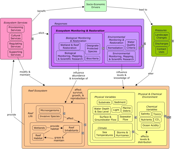
Environmental monitoring describes the processes and activities that need to take place to characterize and monitor the quality of the physical and chemical environment. Environmental restoration refers to responses to directly alter the physical and chemical condition of the reef ecosystem through remediation activities or limits on degradation through water quality criteria.
CMap
CMap Description
A change in the provision of ecosystem services, or a desire to improve provision of ecosystem services, may elicit responses to directly alter the reef ecosystem. Remediation activities can be implemented to physical remove sediment, reduce levels of pollution, or remove marine debris. Water quality criteria can be used to set the maximum desirable levels of contaminants in coastal waters. Additional responses may need to be enacted to ensure that water quality criteria and biocriteria, once established, are achieved and maintained. Monitoring, mapping, and scientific research can be used to better understand changes in condition, bio-physical processes, and interactions among species, and how they may be impacted by various stressors or potential decisions. A healthy functioning reef ecosystem, beyond its existence or cultural value, is essential for a number of ecosystem goods and services, including shoreline protection, fishing, and recreational opportunities.Citations
| Citation | Year | Study Location | Study Type | Database Topics |
|---|---|---|---|---|
| 2011. Nonpoint Source Management Program 2010 Annual Report. Document # DEPLW-1205, Maine Department of Environmental Protection, Augusta, (Maine, USA). | 2011 | Field Study & Monitoring | Agriculture; Banks, Credit, & Securities; Chemical Use Regulations; Domestic Animal Waste; Fertilizer & Pesticide Use; Forestry; Housing; Impervious Surfaces; Microorganisms; Non-point Source Runoff; Nutrients; Physical & Chemical Water Quality Criteria; Point Source Discharges; Surface & Groundwater Flow; Wetlands | |
| Albright, R. 2011. Reviewing the Effects of Ocean Acidification on Sexual Reproduction and Early Life History Stages of Reef-Building Corals. Journal of Marine Biology 2011:1-14. | 2011 | Review; Field Study & Monitoring | Echinoderms; Environmental Monitoring, Mapping, & Scientific Research; Molluscs; Ocean Acidity; Scientific Research; Stony Coral | |
| Anderson, TJ; Nichol, SL; Syms, C; Przeslawski, R; Harris, PT. 2011. Deep-sea bio-physical variables as surrogates for biological assemblages, an example from the Lord Howe Rise. Deep-Sea Research Part II: Topical Studies in Oceanography 58:979-991. | 2011 | US Pacific & Hawaii | GIS & Maps; Decision Support Frameworks & Tools | Biological Monitoring, Mapping, & Scientific Research; Echinoderms; Environmental Monitoring, Mapping, & Scientific Research; Physical Variables; Sediment; Sponges; Water Depth & Sea Level |
| Baker, DM; Kim, K; Andras, JP; Sparks, JP. 2011. Light-mediated (15)N fractionation in Caribbean gorgonian octocorals: implications for pollution monitoring. Coral Reefs 30:709-717. | 2011 | South & Central America; Florida; Caribbean | Field Study & Monitoring; Lab Study | Algae; Environmental Monitoring, Mapping, & Scientific Research; Nutrients; Octocoral; Primary Production; Stony Coral; Zooxanthellae |
| Benzerara, K; Miot, J; Morin, G; Ona-Nguema, G; Skouri-Panet, F; Ferard, C. 2011. Significance, mechanisms and environmental implications of microbial biomineralization. Comptes Rendus Geoscience 343:160-167. | 2011 | France | Review; Field Study & Monitoring; Lab Study | Microorganisms; Remediation |
| Brown, BE; Dunne, RP; Phongsuwan, N; Somerfield, PJ. 2011. Increased sea level promotes coral cover on shallow reef flats in the Andaman Sea, eastern Indian Ocean. Coral Reefs 30:867-878. | 2011 | Indian Ocean; India; Thailand | Field Study & Monitoring | Environmental Monitoring, Mapping, & Scientific Research; Stony Coral; Water Depth & Sea Level |
| Bruno, F; Bianco, G; Muzzupappa, M; Barone, S; Razionale, AV. 2011. Experimentation of structured light and stereo vision for underwater 3D reconstruction. ISPRS Journal of Photogrammetry and Remote Sensing 66:508-518. | 2011 | Field Study & Monitoring; GIS & Maps; Remote Sensing | Environmental Monitoring, Mapping, & Scientific Research | |
| Chen, MC; Frohlich, C; Taylor, FW; Burr, G; van Ufford, AQ. 2011. Arc segmentation and seismicity in the Solomon Islands arc, SW Pacific. Tectonophysics 507:47-69. | 2011 | US Pacific & Hawaii; Australia; Japan; Solomon Islands; Tonga; Java | GIS & Maps; Decision Support Frameworks & Tools | Environmental Monitoring, Mapping, & Scientific Research |
| Claudet, J; Garcia-Charton, JA; Lenfant, P. 2011. Combined Effects of Levels of Protection and Environmental Variables at Different Spatial Resolutions on Fish Assemblages in a Marine Protected Area. Conservation Biology 25:105-114. | 2011 | Field Study & Monitoring; GIS & Maps | Environmental Monitoring, Mapping, & Scientific Research; Fish; Marine Protected Areas; Substrate | |
| Coleman, JB; Yao, XB; Jordan, TR; Madden, M. 2011. Holes in the ocean: Filling voids in bathymetric lidar data. Computers & Geosciences 37:474-484. | 2011 | Florida | Model; GIS & Maps; Remote Sensing | Environmental Monitoring, Mapping, & Scientific Research |
| Denis, V; Debreuil, J; De Palmas, S; Richard, J; Guillaume, MMM; Bruggemann, JH. 2011. Lesion regeneration capacities in populations of the massive coral Porites lutea at Reunion Island: environmental correlates. Marine Ecology Progress Series 428:105-117. | 2011 | Reunion; India | Field Study & Monitoring; Model | Environmental Monitoring, Mapping, & Scientific Research; Light; Non-point Source Runoff; Stony Coral; Zooxanthellae |
| Fablet, R; Pecquerie, L; de Pontual, H; Hoie, H; Millner, R; Mosegaard, H; Kooijman, SALM. 2011. Shedding Light on Fish Otolith Biomineralization Using a Bioenergetic Approach. PLoS One 6. | 2011 | Field Study & Monitoring; Model; Decision Support Frameworks & Tools | Bivalves; Climate; Environmental Monitoring, Mapping, & Scientific Research; Fish; Fishing & Harvesting Management; Fishing Sector; Ocean Acidity | |
| Gopinath, A; Muraleedharan, NS; Chandramohanakumar, N; Jayalakshmi, KV. 2011. Statistical Significance of BioMonitoring of Marine Algae for Trace Metal Levels in a Coral Environment. Environmental Forensics 12:98-105. | 2011 | Field Study & Monitoring; Index or Indicator | Agriculture; Algae; Environmental Monitoring, Mapping, & Scientific Research; Primary Production | |
| Haldar, S; Mody, KH; Jha, B. 2011. Abundance, diversity and antibiotics resistance pattern of Vibrio spp. in coral ecosystem of Kurusadai island. Journal of Basic Microbiology 51:153-162. | 2011 | India | Field Study & Monitoring | Environmental Monitoring, Mapping, & Scientific Research; Lobster, Crab, & Shrimp; Microorganisms; Pathogens; Skeletal Coral |
| Huang, Z; Brooke, BP; Harris, PT. 2011. A new approach to mapping marine benthic habitats using physical environmental data. Continental Shelf Research 31:S4-S16. | 2011 | Australia; Spain | GIS & Maps | Biological Monitoring, Mapping, & Scientific Research; Environmental Monitoring, Mapping, & Scientific Research; Nutrients; Sediment |
| Huvenne, VAI; Tyler, PA; Masson, DG; Fisher, EH; Hauton, C; Huhnerbach, V; Le Bas, TP; Wolff, GA. 2011. A Picture on the Wall: Innovative Mapping Reveals Cold-Water Coral Refuge in Submarine Canyon. PLoS One 6. | 2011 | US East Coast (NC, SC, GA); Europe | GIS & Maps | Environmental Monitoring, Mapping, & Scientific Research; Sediment; Stony Coral; Trawling & Fishing Gear Damage; Water Depth & Sea Level |
| Jameson, S. C., M. V. Erdmann, J. R. Karr, G. R. Gibson, and K. W. Potts. 2011. Charting a Course Toward Diagnostic Monitoring: A Continuing Review of Coral Reef Attributes and a Research Strategy for Creating Coral Reef Indexes of Biotic Integrity. Bulletin of Marine Science | 2011 | Review; Field Study & Monitoring; Index or Indicator | Biocriteria; Environmental Monitoring, Mapping, & Scientific Research; Plankton | |
| Jaramillo, S; Pawlak, G. 2011. AUV-based bed roughness mapping over a tropical reef. Coral Reefs 30:11-23. | 2011 | Field Study & Monitoring; GIS & Maps | Environmental Monitoring, Mapping, & Scientific Research; Substrate | |
| Jayaraju, N; Reddy, BCSR; Reddy, KR. 2011. Anthropogenic impact on Andaman coast monitoring with benthic foraminifera, Andaman Sea, India. Environmental Earth Sciences 62:821-829. | 2011 | India | Field Study & Monitoring | Aquaculture; Environmental Monitoring, Mapping, & Scientific Research; Finfish Harvest; Sediment; Shipping, Storage, & Warehousing; Tourism & Recreation; Waterborne Discharges |
| Kilpatrick, R; Ewing, G; Lamb, T; Welsford, D; Constable, A. 2011. Autonomous video camera system for monitoring impacts to benthic habitats from demersal fishing gear, including longlines. Deep-Sea Research Part I: Oceanographic Research Papers 58:486-491. | 2011 | Australia | Field Study & Monitoring; Decision Support Frameworks & Tools | Environmental Monitoring, Mapping, & Scientific Research; Finfish Harvest; Fish; Fishing Sector; Trawling & Fishing Gear Damage |
| Klemas, V. 2011. Beach Profiling and LIDAR Bathymetry: An Overview with Case Studies. Journal of Coastal Research 27:1019-1028. | 2011 | Global; Florida | Review; Field Study & Monitoring; GIS & Maps; Remote Sensing | Beaches & Nature Parks; Environmental Monitoring, Mapping, & Scientific Research; Sediment; Storms & Hurricanes; Wetlands |
| Klemas, V. 2011. Remote Sensing Techniques for Studying Coastal Ecosystems: An Overview. Journal of Coastal Research 27:2-17. | 2011 | South & Central America; Mexico | Field Study & Monitoring; GIS & Maps; Remote Sensing | Environmental Monitoring, Mapping, & Scientific Research; Nutrients; Salinity; Wetlands |
| Knudby, A; Nordlund, L. 2011. Remote sensing of seagrasses in a patchy multi-species environment. International Journal of Remote Sensing 32:2227-2244. | 2011 | Tanzania | Field Study & Monitoring; GIS & Maps; Remote Sensing | Algae; Environmental Monitoring, Mapping, & Scientific Research; Seagrasses; Water Depth & Sea Level |
| Leon, J; Woodroffe, CD. 2011. Improving the synoptic mapping of coral reef geomorphology using object-based image analysis. International Journal of Geographical Information Science 25:949-969. | 2011 | Field Study & Monitoring; GIS & Maps; Remote Sensing | Environmental Monitoring, Mapping, & Scientific Research | |
| Mallela, J; Hermann, J; Rapp, RP; Eggins, SM. 2011. Fine-scale phosphorus distribution in coral skeletons: combining X-ray mapping by electronprobe microanalysis and LA-ICP-MS. Coral Reefs 30:813-818. | 2011 | GIS & Maps | Environmental Monitoring, Mapping, & Scientific Research; Non-point Source Runoff; Nutrients | |
| Maynard, JA; Anthony, KRN; Harvell, CD; Burgman, MA; Beeden, R; Sweatman, H; Heron, SF; Lamb, JB; Willis, BL. 2011. Predicting outbreaks of a climate-driven coral disease in the Great Barrier Reef. Coral Reefs 30:485-495. | 2011 | US Pacific & Hawaii; Australia | Field Study & Monitoring; Model; GIS & Maps; Decision Support Frameworks & Tools | Climate; Environmental Monitoring, Mapping, & Scientific Research; Pathogens; Sea Temperatures |
| Navalgund, RR; Singh, RP. 2011. Climate Change Studies Using Space Based Observation. Journal of the Indian Society of Remote Sensing 39:281-295. | 2011 | Global; India | Review; Field Study & Monitoring; Model; Index or Indicator; GIS & Maps | Climate; Deforestation & Devegetation; Environmental Monitoring, Mapping, & Scientific Research; Forestry; Greenhouse Gas Emissions; Housing; Irrigation; Light; Salinity; Water Depth & Sea Level; Wetlands |
| Oigman-Pszczol, SS; Creed, JC. 2011. Can patterns in benthic communities be explained by an environmental pressure index? Marine Pollution Bulletin 62:2181-2189. | 2011 | US East Coast (NC, SC, GA) | Field Study & Monitoring; Index or Indicator | Biological Monitoring, Mapping, & Scientific Research; Environmental Monitoring, Mapping, & Scientific Research; Stony Coral |
| Rasheed, M; Mian, S; Aubrey, D. 2011. Guidelines for EIA of fish and shrimp hatcheries in a semi-enclosed water body. Ocean and Coastal Management 54:678-686. | 2011 | Field Study & Monitoring | Aquaculture; Environmental Monitoring, Mapping, & Scientific Research; Finfish Harvest; Fish; Fishing Sector; Lobster, Crab, & Shrimp; Mitigation; Sediment | |
| Rouphael, AB; Abdulla, A; Said, Y. 2011. A framework for practical and rigorous impact monitoring by field managers of marine protected areas. Environmental Monitoring and Assessment 180:557-572. | 2011 | Australia; Egypt | Review; Field Study & Monitoring | Banks, Credit, & Securities; Collaboration & Partnering; Dive, Snorkeling, & Swimming Tourism; Environmental Monitoring, Mapping, & Scientific Research; Marine Protected Areas; Mitigation; Pathogens |
| Sato, Y; Bourne, DG; Willis, BL. 2011. Effects of temperature and light on the progression of black band disease on the reef coral, Montipora hispida. Coral Reefs 30:753-761. | 2011 | South & Central America; Australia; Caribbean | Field Study & Monitoring | Environmental Monitoring, Mapping, & Scientific Research; Microorganisms; Pathogens; Stony Coral; Surface & Groundwater Flow |
| Shefferson, RP; McCormick, MK; Whigham, DF; O'Neill, JP. 2011. Life history strategy in herbaceous perennials: inferring demographic patterns from the aboveground dynamics of a primarily subterranean, myco-heterotrophic orchid. Oikos 120:1291-1300. | 2011 | Field Study & Monitoring; Model | Environmental Monitoring, Mapping, & Scientific Research; Primary Production | |
| Storlazzi, CD; Field, ME; Bothner, MH. 2011. The use (and misuse) of sediment traps in coral reef environments: theory, observations, and suggested protocols. Coral Reefs 30:23-38. | 2011 | US Pacific & Hawaii | Review; Field Study & Monitoring; Decision Support Frameworks & Tools | Environmental Monitoring, Mapping, & Scientific Research; Sediment; Substrate |
| Storlazzi, CD; Fregoso, TA; Golden, NE; Finlayson, DP. 2011. Sediment dynamics and the burial and exhumation of bedrock reefs along an emergent coastline as elucidated by repetitive sonar surveys: Northern Monterey Bay, CA. Marine Geology 289:46-59. | 2011 | US Pacific & Hawaii; Pacific Ocean | Model; GIS & Maps | Biological Monitoring, Mapping, & Scientific Research; Complex Habitat & Resources; Environmental Monitoring, Mapping, & Scientific Research; Sediment; Storms & Hurricanes; Surface & Groundwater Flow; Water Depth & Sea Level |
| Storlazzi, D. C., M. E. Field, a nd M. H. Bothner. 2011. The use (and misuse) of sediment traps in coral reef environments: theory, observations, and suggested protocols. Coral Reefs 30:23-38. | 2011 | Review; Field Study & Monitoring; Decision Support Frameworks & Tools | Environmental Monitoring, Mapping, & Scientific Research; Sediment; Substrate | |
| Teresa, FB; Romero, RD; Casatti, L; Sabino, J. 2011. Fish as Indicators of Disturbance in Streams Used for Snorkeling Activities in a Tourist Region. Environmental Management 47:960-968. | 2011 | US East Coast (NC, SC, GA) | Field Study & Monitoring; Index or Indicator | Complex Habitat & Resources; Dive, Snorkeling, & Swimming Tourism; Environmental Monitoring, Mapping, & Scientific Research; Fish; Surface & Groundwater Flow; Tourism & Recreation |
| Wan, YT; Liu, JY; Li, W; Meng, FL; Jin, Z; Yu, XY; Huang, XJ; Liu, JH. 2011. Dense doping of indium to coral-like SnO(2) nanostructures through a plasma-assisted strategy for sensitive and selective detection of chlorobenzene. Nanotechnology 22. | 2011 | Field Study & Monitoring | Environmental Monitoring, Mapping, & Scientific Research | |
| Wedding, L. M., C. A. Lepczyk, S. J. Pittman, A. M. Friedlander, and S. Jorgensen. 2011. Quantifying seascape structure: extending terrestrial spatial pattern metrics to the marine realm. Marine Ecology Progress Series 427:219-232. | 2011 | US Pacific & Hawaii | Review; Field Study & Monitoring; Model; Index or Indicator; Remote Sensing | Environmental Monitoring, Mapping, & Scientific Research |
| Whatmough, S; Van Putten, I; Chin, A. 2011. From hunters to nature observers: a record of 53 years of diver attitudes towards sharks and rays and marine protected areas. Marine and Freshwater Research 62:755-763. | 2011 | Australia; Cuba | Field Study & Monitoring | Apex Fish Predators; Dive, Snorkeling, & Swimming Tourism; Environmental Monitoring, Mapping, & Scientific Research; Finfish Harvest; Fish; Marine Protected Areas; Tourism & Recreation |
| Whitall, D. R., B. M. Costa, L. J. Bauer, A. Dieppa, and S. D. Hile, editors. 2011. A Baseline Assessment of the Ecological Resources of Jobos Bay, Puerto Rico. NOAA Technical Memorandum NOS NCCOS 133, NOAA, Silver Spring, (MD, USA). | 2011 | Puerto Rico | Field Study & Monitoring; Model; GIS & Maps | Agriculture; Chemical Use Regulations; Collaboration & Partnering; Environmental Monitoring, Mapping, & Scientific Research; Fertilizer & Pesticide Use; Marine Debris; Nutrients; Sediment; Surface & Groundwater Flow; Toxics |
| Wu, JJ; Mak, YL; Murphy, MB; Lam, JCW; Chan, WH; Wang, MF; Chan, LL; Lam, PKS. 2011. Validation of an accelerated solvent extraction liquid chromatography-tandem mass spectrometry method for Pacific ciguatoxin-1 in fish flesh and comparison with the mouse neuroblastoma assay. Analytical and Bioanalytical Chemistry 400:3165-3175. | 2011 | Global; US Pacific & Hawaii; Java | Field Study & Monitoring | Apex Fish Predators; Environmental Monitoring, Mapping, & Scientific Research; Fish; Piscivorous Fish |
| Zhang, FF; Cai, WY; Zhu, JC; Sun, ZR; Zhang, J. 2011. In Situ Raman Spectral Mapping Study on the Microscale Fibers in Blue Coral (Heliopora coerulea) Skeletons. Analytical Chemistry 83:7870-7875. | 2011 | GIS & Maps | Calcium Carbonate Deposition; Environmental Monitoring, Mapping, & Scientific Research; Octocoral; Stony Coral | |
| 2010. USVI Integrated Water Quality Monitoring & Assessment Report. Department of Planning & Natural Resources. | 2010 | US Virgin Islands | Field Study & Monitoring | Environmental Monitoring, Mapping, & Scientific Research; Surface & Groundwater Flow |
| Callaway, R., N. Desroy, S. F. Dubois, J. Fournier, M. Frost, L. Godet, V. J. Hendrick, and M. Rabaut. 2010. Ephemeral Bio-engineers or Reef-building Polychaetes: How Stable are Aggregations of the Tube Worm Lanice conchilega (Pallas, 1766)? Integrative And Comparative Biology 50:237-250. | 2010 | Europe; France | Field Study & Monitoring | Biological Monitoring, Mapping, & Scientific Research; Environmental Monitoring, Mapping, & Scientific Research; Marine Worms; Sediment |
| Chabanet, P., N. Guillemot, M. Kulbicki, L. Vigliola, and S. Sarramegna. 2010. Baseline study of the spatio-temporal patterns of reef fish assemblages prior to a major mining project in New Caledonia (South Pacific). Marine Pollution Bulletin 61:598-611. | 2010 | US Pacific & Hawaii; Australia; New Caledonia | Field Study & Monitoring; Index or Indicator | Dredging, Draining, & Filling; Environmental Monitoring, Mapping, & Scientific Research; Finfish Harvest; Fish; Non-point Source Runoff; Sediment |
| Cortes, J., C. E. Jimenez, A. C. Fonseca, and J. J. Alvarado. 2010. Status and conservation of coral reefs in Costa Rica. Revista de Biologia Tropical 58:33-50. | 2010 | South & Central America; US Pacific & Hawaii; Costa Rica; Caribbean | Field Study & Monitoring | Environmental Monitoring, Mapping, & Scientific Research; Sediment |
| Evans, S. N. and D. A. Abdo. 2010. A cost-effective technique for measuring relative water movement for studies of benthic organisms. Marine and Freshwater Research 61:1327-1335. | 2010 | Australia | Field Study & Monitoring | Environmental Monitoring, Mapping, & Scientific Research; Shoreline Protection |
| Fautin, D., P. Dalton, L. S. Incze, J. A. C. Leong, C. Pautzke, A. Rosenberg, P. Sandifer, G. Sedberry, J. W. Tunnell, I. Abbott, R. E. Brainard, M. Brodeur, L. G. Eldredge, M. Feldman, F. Moretzsohn, P. S. Vroom, M. Wainstein, and N. Wolff. 2010. An Overview of Marine Biodiversity in United States Waters. PLoS One 5:e11914. | 2010 | Global | Field Study & Monitoring; Lab Study | Banks, Credit, & Securities; CO2; Coastal Development; Environmental Monitoring, Mapping, & Scientific Research; Invasive Species; Shipping, Storage, & Warehousing |
| Foden, J., S. I. Rogers, and A. P. Jones. 2010. Recovery of UK seabed habitats from benthic fishing and aggregate extraction-towards a cumulative impact assessment. Marine Ecology Progress Series 411:259-270. | 2010 | Europe; England | Review; Field Study & Monitoring | Complex Habitat & Resources; Dredging, Draining, & Filling; Environmental Monitoring, Mapping, & Scientific Research; Finfish Harvest; Sediment; Trawling & Fishing Gear Damage |
| Fujita, R. M., K. T. Honey, A. Morris, J. R. Wilson, and H. Russell. 2010. Cooperative Strategies In Fisheries Management: Integrating Across Scales. Bulletin of Marine Science 86:251-271. | 2010 | Field Study & Monitoring | Environmental Monitoring, Mapping, & Scientific Research; Finfish Harvest; Fishing & Harvesting Management; Fishing Sector; Funding & Incentives | |
| Garzon-Ferreira, J. and A. Rodriguez-Ramirez. 2010. SIMAC: Development and implementation of a coral reef monitoring network in Colombia. Revista de Biologia Tropical 58:67-80. | 2010 | Global; South & Central America; US Pacific & Hawaii; Caribbean | Field Study & Monitoring | Docks & Marinas; Environmental Monitoring, Mapping, & Scientific Research; Fish; Internet & Telecommunications; Octocoral; Pathogens; Salinity |
| Gavio, B., S. Palmer-Cantillo, and J. E. Mancera. 2010. Historical analysis (2000-2005) of the coastal water quality in San Andres Island, Sea Flower Biosphere Reserve, Caribbean Colombia. Marine Pollution Bulletin 60:1018-1030. | 2010 | South & Central America; Caribbean | Field Study & Monitoring; Decision Support Frameworks & Tools | Discharges; Microorganisms; Nutrients; Pathogens; Seagrasses |
| Goffredo, S., F. Pensa, P. Neri, A. Orlandi, M. S. Gagliardi, A. Velardi, C. Piccinetti, and F. Zaccanti. 2010. Unite research with what citizens do for fun: "recreational monitoring'' of marine biodiversity. Ecological Applications 20:2170-2187. | 2010 | Cuba | Field Study & Monitoring; Index or Indicator | Dive, Snorkeling, & Swimming Tourism; Environmental Education & Outreach; Environmental Monitoring, Mapping, & Scientific Research; Social Organizations; Tourism & Recreation; Travel Services & Tour Operators |
| Haas, A., M. el-Zibdah, and C. Wild. 2010. Seasonal monitoring of coral-algae interactions in fringing reefs of the Gulf of Aqaba, Northern Red Sea. Coral Reefs 29:93-103. | 2010 | Field Study & Monitoring | Algae; Environmental Monitoring, Mapping, & Scientific Research; Fleshy Macroalgae; Nutrients; Stony Coral; Turf Algae; Water Depth & Sea Level | |
| Hamouda, A. Z. and K. M. Abdel-Salam. 2010. Estuarine Habitat Assessment for Construction of a Submarine Transmission Line. Surveys In Geophysics 31:449-463. | 2010 | Egypt | GIS & Maps; Decision Support Frameworks & Tools | Environmental Monitoring, Mapping, & Scientific Research; Invertebrates; Marine Worms; Mitigation; Pipelines; Sediment; Utility Line Construction & Maintenance; Water Depth & Sea Level |
| Henriques, A. P. M., A. D. D. Neto, and R. F. Amaral. 2010. Classification of multispectral images in coral environments using a hybrid of classifier ensembles. Neurocomputing 73:1256-1264. | 2010 | GIS & Maps; Remote Sensing | Environmental Monitoring, Mapping, & Scientific Research | |
| Jimenez, H., P. Dumas, L. Bigot, J. M. Amouroux, and J. Ferraris. 2010. Taxonomic resolution needed to describe invertebrate assemblages and to detect harvesting effects on coral reef ecosystems. Marine Ecology Progress Series 406:211-222. | 2010 | US Pacific & Hawaii; Australia; New Caledonia | Field Study & Monitoring | Environmental Monitoring, Mapping, & Scientific Research; Marine Protected Areas; Seagrasses |
| Kaczmarek, S. E., M. K. Hicks, S. M. Fullmer, K. L. Steffen, and S. L. Bachtel. 2010. Mapping facies distributions on modern carbonate platforms through integration of multispectral Landsat data, statistics-based unsupervised classifications, and surface sediment data. AAPG Bulletin 94:1581-1606. | 2010 | Global; South & Central America; Indian Ocean; Bahamas; Belize; India; Mexico | GIS & Maps | Environmental Monitoring, Mapping, & Scientific Research; Sediment |
| Kawabata, Y., J. Okuyama, K. Asami, K. Okuzawa, K. Yoseda, and N. Arai. 2010. Effects of a tropical cyclone on the distribution of hatchery-reared black-spot tuskfish Choerodon schoenleinii determined by acoustic telemetry. Journal of Fish Biology 77:627-642. | 2010 | Japan | Field Study & Monitoring; Model | Environmental Monitoring, Mapping, & Scientific Research; Fish; Storms & Hurricanes |
| Keene, A. F., S. G. Johnston, R. T. Bush, E. D. Burton, and L. A. Sullivan. 2010. Reactive trace element enrichment in a highly modified, tidally inundated acid sulfate soil wetland: East Trinity, Australia. Marine Pollution Bulletin 60:620-626. | 2010 | Australia | Mangroves; Remediation; Sediment; Wetlands | |
| Kendall, M. S. and T. J. Miller. 2010. Relationships among map resolution, fish assemblages, and habitat variables in a coral reef ecosystem. Hydrobiologia 637:101-119. | 2010 | South & Central America; US Virgin Islands; Caribbean | GIS & Maps | Environmental Monitoring, Mapping, & Scientific Research; Fish |
| Knudby, A., C. Newman, Y. Shaghude, and C. Muhando. 2010. Simple and effective monitoring of historic changes in nearshore environments using the free archive of Landsat imagery. International Journal of Applied Earth Observation and Geoinformation 12:S116-S122. | 2010 | Field Study & Monitoring; GIS & Maps | Algae; Environmental Monitoring, Mapping, & Scientific Research; Seagrasses; Substrate | |
| Koss, R. S. and J. Y. Kingley. 2010. Volunteer health and emotional wellbeing in marine protected areas. Ocean and Coastal Management 53:447-453. | 2010 | Australia | Field Study & Monitoring | Environmental Monitoring, Mapping, & Scientific Research; Marine Protected Areas |
| Litaker, R. W., M. W. Vandersea, M. A. Faust, S. R. Kibler, A. W. Nau, W. C. Holland, M. Chinain, M. J. Holmes, and P. A. Tester. 2010. Global distribution of ciguatera causing dinoflagellates in the genus Gambierdiscus. Toxicon 56:711-730. | 2010 | Global; South & Central America; US Pacific & Hawaii; US East Coast (NC, SC, GA); Belize; Caribbean; Mexico | Field Study & Monitoring | Environmental Monitoring, Mapping, & Scientific Research; Fish |
| Locker, S. D., R. A. Armstrong, T. A. Battista, J. J. Rooney, C. Sherman, and D. G. Zawada. 2010. Geomorphology of mesophotic coral ecosystems: current perspectives on morphology, distribution, and mapping strategies. Coral Reefs 29:329-345. | 2010 | South & Central America; Florida; US Pacific & Hawaii; Caribbean; Mexico | Review; GIS & Maps | Environmental Monitoring, Mapping, & Scientific Research; Substrate |
| Main, W. P. L., C. Ross, and G. K. Bielmyer. 2010. Copper accumulation and oxidative stress in the sea anemone, Aiptasia pallida, after waterborne copper exposure. Comparative Biochemistry And Physiology C-toxicology & Pharmacology 151:216-221. | 2010 | Field Study & Monitoring; Model | Anemones & Zooanthids; Environmental Monitoring, Mapping, & Scientific Research; Zooxanthellae | |
| May-Ku, M. A., P. L. Ardisson, and U. Ordonez-Lopez. 2010. Morphological variation of Thalassia testudinum in two shallow coastal environments from the southeastern Gulf of Mexico. Botanica Marina 53:449-455. | 2010 | South & Central America; US East Coast (NC, SC, GA); Mexico | Field Study & Monitoring | Environmental Monitoring, Mapping, & Scientific Research; Seagrasses |
| Meyer, C. G., Y. P. Papastamatiou, and T. B. Clark. 2010. Differential movement patterns and site fidelity among trophic groups of reef fishes in a Hawaiian marine protected area. Marine Biology 157:1499-1511. | 2010 | US Pacific & Hawaii | Field Study & Monitoring | Corallivorous Fish; Fish; Invertivorous Fish; Large Herbivorous Fish; Marine Protected Areas; Small Herbivorous Fish |
| Myers, T. S., I. Atkinson, and R. Johnstone. 2010. Supporting Coral Reef Ecosystems Research Through Modelling A Reusable Ontology Framework. Applied Artificial Intelligence 24:77-101. | 2010 | Field Study & Monitoring; Model | Environmental Monitoring, Mapping, & Scientific Research | |
| Narayan, Y. R. and J. M. Pandolfi. 2010. Benthic foraminiferal assemblages from Moreton Bay, South-East Queensland, Australia: Applications in monitoring water and substrate quality in subtropical estuarine environments. Marine Pollution Bulletin 60:2062-2078. | 2010 | Australia | Field Study & Monitoring; Index or Indicator | Environmental Monitoring, Mapping, & Scientific Research; Salinity; Sediment; Substrate |
| Niggl, W. and C. Wild. 2010. Spatial distribution of the upside-down jellyfish Cassiopea sp. within fringing coral reef environments of the Northern Red Sea: implications for its life cycle. Helgoland Marine Research 64:281-287. | 2010 | Field Study & Monitoring; Index or Indicator | Complex Habitat & Resources; Environmental Monitoring, Mapping, & Scientific Research; Invasive Species; Mangroves; Nutrients; Seagrasses | |
| Osmond, D. L. 2010. USDA water quality projects and the National Institute of Food and Agriculture Conservation Effects Assessment Project watershed studies. Journal of Soil and Water Conservation 35:142A-146A. | 2010 | India | Field Study & Monitoring; Model | Agriculture; Environmental Monitoring, Mapping, & Scientific Research; Housing; Landscape Conservation & Restoration; Physical & Chemical Water Quality Criteria; Point & Mobile Source Controls; Point Source Discharges |
| Pittman, S. J., C. F. G. Jeffrey, R. Clark, K. Woody, B. D. Herlach, C. Caldow, M. E. Monaco, and R. Appledoorn. 2010. Coral reef ecosystems of Reserva Natural de La Parguera (Puerto Rico): spatial and temporal patterns in fish and benthic communities (2001-2007). National Oceanic and Atmospheric Administration, Silver Spring, MD. | 2010 | South & Central America; Puerto Rico; Caribbean | Field Study & Monitoring | Biological Monitoring, Mapping, & Scientific Research; Boating Activities; Boating Regulations; Collaboration & Partnering; Dive, Snorkeling, & Swimming Tourism; Environmental Monitoring, Mapping, & Scientific Research; Fish; Fishing Sector; Landscape Conservation & Restoration; Mangroves; Marine Debris; Marine Protected Areas; Tourism & Recreation |
| Ramos, C. A. C., F. D. Amaral, R. K. P. de Kikuchi, E. M. Chaves, and G. R. de Melo. 2010. Quantification of reef benthos communities and variability inherent to the monitoring using video transect method. Environmental Monitoring and Assessment 162:95-101. | 2010 | Field Study & Monitoring; Index or Indicator | Environmental Monitoring, Mapping, & Scientific Research | |
| Rodriguez-Martinez, R. E., F. Ruiz-Renteria, B. van Tussenbroek, G. Barba-Santos, E. Escalante-Mancera, G. Jordan-Garza, and E. Jordan-Dahlgren. 2010. Environmental state and tendencies of the Puerto Morelos CARICOMP site, Mexico. Revista de Biologia Tropical 58:23-43. | 2010 | South & Central America; Oman; Mexico | Field Study & Monitoring | Algae; Environmental Monitoring, Mapping, & Scientific Research; Fleshy Macroalgae; Sea Urchins; Seagrasses; Sponges; Storms & Hurricanes; Tourism & Recreation; Turf Algae |
| Roelfsema, C. and S. Phinn. 2010. Integrating field data with high spatial resolution multispectral satellite imagery for calibration and validation of coral reef benthic community maps. Journal of Applied Remote Sensing 4:43527. | 2010 | Fiji | Field Study & Monitoring; GIS & Maps; Remote Sensing | Complex Habitat & Resources; Environmental Monitoring, Mapping, & Scientific Research; Seagrasses |
| Rosenfelder, N., N. J. Van Zee, J. F. Mueller, C. Gaus, and W. Vetter. 2010. Gas Chromatography/Electron Ionization-Mass Spectrometry-Selected Ion Monitoring Screening Method for a Thorough Investigation of Polyhalogenated Compounds in Passive Sampler Extracts with Quadrupole Systems. Analytical Chemistry 82:9835-9842. | 2010 | Field Study & Monitoring | Environmental Monitoring, Mapping, & Scientific Research; Pharmaceuticals & Cosmetics Sources | |
| Scott, C., S. E. Lewis, R. Milla, M. C. Taylor, A. J. W. Rodgers, G. Dumsday, J. E. Brodie, J. G. Oakeshott, and R. J. Russell. 2010. A free-enzyme catalyst for the bioremediation of environmental atrazine contamination. Journal of Environmental Management 91:2075-2078. | 2010 | Australia | Field Study & Monitoring | Agriculture; Fertilizer & Pesticide Use; Remediation |
| Shaw, M., M. J. Furnas, K. Fabricius, D. Haynes, S. Carter, G. Eaglesham, and J. F. Mueller. 2010. Monitoring pesticides in the Great Barrier Reef. Marine Pollution Bulletin 60:113-122. | 2010 | Australia | Field Study & Monitoring; Decision Support Frameworks & Tools | Agriculture; Environmental Monitoring, Mapping, & Scientific Research; Fertilizer & Pesticide Use; Non-point Source Runoff; Surface & Groundwater Flow |
| Speed, C. W., I. C. Field, M. G. Meekan, and C. J. A. Bradshaw. 2010. Complexities of coastal shark movements and their implications for management. Marine Ecology Progress Series 408:275-U305. | 2010 | Global | Field Study & Monitoring | Apex Fish Predators; Environmental Monitoring, Mapping, & Scientific Research; Finfish Harvest; Marine Protected Areas; Salinity |
| Steiner, S. C. C. and D. A. Willette. 2010. Distribution and size of benthic marine habitats in Dominica, Lesser Antilles. Revista de Biologia Tropical 58:589-602. | 2010 | Antilles | Field Study & Monitoring; GIS & Maps | Environmental Monitoring, Mapping, & Scientific Research; Invasive Species; Ports & Harbors; Seagrasses |
| van Oosterom, J., S. C. King, A. Negri, C. Humphrey, and J. Mondon. 2010. Investigation of the mud crab (Scylla serrata) as a potential bio-monitoring species for tropical coastal marine environments of Australia. Marine Pollution Bulletin 60:283-290. | 2010 | Australia | Field Study & Monitoring; Index or Indicator | Environmental Monitoring, Mapping, & Scientific Research; Lobster, Crab, & Shrimp; Surface & Groundwater Flow |
| Vroom, P. S. and C. L. Braun. 2010. Benthic composition of a healthy subtropical reef: baseline species-level cover, with an emphasis on algae, in the Northwestern Hawaiian Islands. PLoS One 5:e9733. | 2010 | Global; US Pacific & Hawaii | Field Study & Monitoring | Algae; Complex Habitat & Resources; Environmental Monitoring, Mapping, & Scientific Research; Fish; Fleshy Macroalgae; Ocean Acidity; Stony Coral; Substrate |
| Wilson, B. 2010. Effect Of Hurricanes On Guilds Of Nearshore Epiphytal Foraminifera, Nevis, West Indies. Journal of Foraminiferal Research 40:327-343. | 2010 | South & Central America; Caribbean | Field Study & Monitoring | Calcareous Macroalgae; Environmental Monitoring, Mapping, & Scientific Research; Nutrients; Storms & Hurricanes; Substrate |
| [No author name available]. 2009. Green light for Gorgon gas project, but environmental conditions apply. Chemical Engineer 816:13. | 2009 | Australia | Field Study & Monitoring | Environmental Monitoring, Mapping, & Scientific Research; Natural Gas & Electric Power; Pipelines; Sea Turtles; Shipping, Storage, & Warehousing |
| Anderson, T. J., C. Syms, D. A. Roberts, and D. F. Howard. 2009. Multi-scale fish-habitat associations and the use of habitat surrogates to predict the organisation and abundance of deep-water fish assemblages. Journal of Experimental Marine Biology and Ecology 379:34-42. | 2009 | GIS & Maps | Complex Habitat & Resources; Environmental Monitoring, Mapping, & Scientific Research; Fish; Landscape Conservation & Restoration; Sediment | |
| Aubert, A., C. E. Lazareth, G. Cabioch, H. Boucher, T. Yamada, Y. Iryu, and R. Farman. 2009. The tropical giant clam Hippopus hippopus shell, a new archive of environmental conditions as revealed by sclerochronological and delta O-18 profiles. Coral Reefs 28:989-998. | 2009 | US Pacific & Hawaii; New Caledonia | Field Study & Monitoring | Environmental Monitoring, Mapping, & Scientific Research |
| Avila, E. and J. L. Carballo. 2009. A preliminary assessment of the invasiveness of the Indo-Pacific sponge Chalinula nematifera on coral communities from the tropical Eastern Pacific. Biological Invasions 11:257-264. | 2009 | US Pacific & Hawaii; Pacific Ocean | Field Study & Monitoring | Environmental Monitoring, Mapping, & Scientific Research; Invasive Species; Sponges; Stony Coral |
| Bainbridge, Z. T., J. E. Brodie, J. W. Faithful, D. A. Sydes, and S. E. Lewis. 2009. Identifying the land-based sources of suspended sediments, nutrients and pesticides discharged to the Great Barrier Reef from the Tully-Murray Basin, Queensland, Australia. Marine and Freshwater Research 60:1081-1090. | 2009 | Australia | Field Study & Monitoring | Agriculture; Discharges; Dredging, Draining, & Filling; Fertilizer & Pesticide Use; Non-point Source Runoff; Nutrients; Seagrasses; Sediment; Surface & Groundwater Flow; Wetlands |
| Barbosa, C. F., M. D. Prazeres, B. P. Ferreira, and J. C. S. Seoane. 2009. Foraminiferal assemblage and reef check census in coral reef health monitoring of East Brazilian margin. Marine Micropaleontology 73:62-69. | 2009 | Global; South & Central America; US East Coast (NC, SC, GA); Atlantic Ocean; Caribbean | Field Study & Monitoring; Index or Indicator | Environmental Monitoring, Mapping, & Scientific Research; Light; Marine Protected Areas; Stony Coral |
| Baron, J. S., L. Gunderson, C. D. Allen, E. Fleishman, D. McKenzie, L. A. Meyerson, J. Oropeza, and N. Stephenson. 2009. Options for National Parks and Reserves for Adapting to Climate Change. Environmental Management 44:1033-1042. | 2009 | Field Study & Monitoring; Decision Support Frameworks & Tools | Climate; Cultural Policies; Cultural Protections; Environmental Monitoring, Mapping, & Scientific Research; Resource Use Management | |
| Boyer, J. N. and H. O. Briceno. 2009. 2009 annual report of the water quality monitoring project for the water quality protection program of the Florida Keys National Marine Sactuary. Florida International University, Miami, FL. | 2009 | Florida | Field Study & Monitoring | Light; Nutrients; Salinity |
| Bradley, P., W. S. Fisher, H. Bell, W. Davis, V. Chan, C. LoBue, and W. Wiltse. 2009. Development and implementation of coral reef biocriteria in US jurisdictions. Environmental Monitoring and Assessment 150:43-51. | 2009 | Global; US Virgin Islands | Review; Field Study & Monitoring | Biocriteria; Biological Monitoring, Mapping, & Scientific Research; Climate; Environmental Monitoring, Mapping, & Scientific Research; Finfish Harvest; Physical & Chemical Water Quality Criteria; Physical Damage; Sea Temperatures; Shoreline Protection; Stony Coral; Tourism & Recreation |
| Bradley, P., W. S. Fisher, H. Bell, W. Davis, V. Chan, C. LoBue, W. Wiltse. 2009. Development and implementation of coral reef biocriteria in U.S. jurisdictions. Environmental Monitoring and Assessment 150:43-51. | 2009 | Global; US Virgin Islands | Review; Field Study & Monitoring | Biocriteria; Biological Monitoring, Mapping, & Scientific Research; Climate; Environmental Monitoring, Mapping, & Scientific Research; Finfish Harvest; Physical & Chemical Water Quality Criteria; Physical Damage; Sea Temperatures; Shoreline Protection; Stony Coral; Tourism & Recreation |
| Brock, J. C. and S. J. Purkis. 2009. The Emerging Role of Lidar Remote Sensing in Coastal Research and Resource Management. Journal of Coastal Research 25:1-5. | 2009 | GIS & Maps; Remote Sensing | Environmental Monitoring, Mapping, & Scientific Research; Resource Use Management; Scientific Research; Storms & Hurricanes | |
| Bunge, M. and U. Lechner. 2009. Anaerobic reductive dehalogenation of polychlorinated dioxins. Applied Microbiology and Biotechnology 84:429-444. | 2009 | Review | Microorganisms; Remediation; Sediment | |
| Chatterjea, S. and P. Havinga. 2009. Improving Temporal Coverage of an Energy-Efficient Data Extraction Algorithm for Environmental Monitoring Using Wireless Sensor Networks. Sensors 9:4941-4954. | 2009 | Australia | Field Study & Monitoring | Environmental Monitoring, Mapping, & Scientific Research |
| Clark, M. R. and A. A. Rowden. 2009. Effect of deepwater trawling on the macro-invertebrate assemblages of seamounts on the Chatham Rise, New Zealand. Deep-Sea Research Part I: Oceanographic Research Papers 56:1540-1554. | 2009 | Field Study & Monitoring; Index or Indicator | Commercial Fisheries; Environmental Monitoring, Mapping, & Scientific Research; Finfish Harvest; Fishing Sector; Mineral, Rock, & Metal Mining; Stony Coral; Substrate; Trawling & Fishing Gear Damage | |
| Cooper, T. F., J. P. Gilmour, and K. E. Fabricius. 2009. Bioindicators of changes in water quality on coral reefs: review and recommendations for monitoring programmes. Coral Reefs 18-Jan. | 2009 | Review; Field Study & Monitoring; Index or Indicator | Complex Habitat & Resources; Environmental Monitoring, Mapping, & Scientific Research; Nutrients; Sediment; Stony Coral | |
| Costa, B. M., T. A. Battista, and S. J. Pittman. 2009. Comparative evaluation of airborne LiDAR and ship-based multibeam SoNAR bathymetry and intensity for mapping coral reef ecosystems. Remote Sensing of Environment 113:1082-1100. | 2009 | Field Study & Monitoring; GIS & Maps; Remote Sensing | Environmental Monitoring, Mapping, & Scientific Research; Sediment | |
| Cottin, A. G., D. L. Forbes, and B. F. Long. 2009. Shallow seabed mapping and classification using waveform analysis and bathymetry from SHOALS lidar data. Canadian Journal of Remote Sensing 35:422-434. | 2009 | GIS & Maps; Remote Sensing | Environmental Monitoring, Mapping, & Scientific Research; Sediment; Shoreline Protection | |
| de Freitas, D. M., S. Kininmonth, and S. Woodley. 2009. Linking science and management in the adoption of sensor network technology in the Great Barrier Reef coast, Australia. Computers, Environment and Urban Systems 33:111-121. | 2009 | Australia | Field Study & Monitoring | Biological Monitoring, Mapping, & Scientific Research; Environmental Monitoring, Mapping, & Scientific Research; Infrastructural Policies; Infrastructure; Light; Surface & Groundwater Flow |
| de Freitas, M. C., R. H. S. D. Vieira, and M. E. de Araujo. 2009. Impact of the Construction of the Harbor at Pecem (Ceara, Brazil) upon Reef Fish Communities in Tide Pools. Brazilian Archives of Biology and Technology 52:187-195. | 2009 | Field Study & Monitoring; Index or Indicator | Biological Monitoring, Mapping, & Scientific Research; Dredging, Draining, & Filling; Environmental Monitoring, Mapping, & Scientific Research; Fish; Ports & Harbors; Small Herbivorous Fish | |
| DiDonato, G. T., E. M. DiDonato, L. M. Smith, L. C. Harwell, and J. K. Summers. 2009. Assessing coastal waters of American Samoa: territory-wide water quality data provide a critical "big-picture" view for this tropical archipelago. Environmental Monitoring and Assessment 150:157-165. | 2009 | US Pacific & Hawaii; Australia; Samoa; American Samoa | Nutrients; Physical & Chemical Water Quality Criteria | |
| Eberhard, R., C. J. Robinson, J. Waterhouse, J. Parslow, B. Hart, R. Grayson, and B. Taylor. 2009. Adaptive management for water quality planning - from theory to practice. Marine and Freshwater Research 60:1189-1195. | 2009 | Australia | Field Study & Monitoring | Collaboration & Partnering; Environmental Monitoring, Mapping, & Scientific Research; Resource Use Management |
| Energy Efficiency & Renewable Energy. 2009. Report to Congress on the Potential Environmental Effects of Marine and Hydrokinetic Energy Technologies. Department of Energy. | 2009 | Review; Field Study & Monitoring | Cultural Policies; Environmental Monitoring, Mapping, & Scientific Research; Fish; Mitigation; Surface & Groundwater Flow; Tourism & Recreation; Utility Line Construction & Maintenance; Utility Policies | |
| Fancy, S. G., J. E. Gross, and S. L. Carter. 2009. Monitoring the condition of natural resources in US national parks. Environmental Monitoring and Assessment 151:161-174. | 2009 | Field Study & Monitoring; Model; Index or Indicator | Environmental Monitoring, Mapping, & Scientific Research | |
| Forst, M. F. 2009. The convergence of Integrated Coastal Zone Management and the ecosystems approach. Ocean and Coastal Management 52:294-306. | 2009 | South & Central America; Australia; Belize | Field Study & Monitoring; Model; Index or Indicator | Environmental Monitoring, Mapping, & Scientific Research; Landuse Management; Marine Protected Areas |
| Foster, G., B. K. Walker, and B. M. Riegl. 2009. Interpretation of Single-Beam Acoustic Backscatter Using Lidar-Derived Topographic Complexity and Benthic Habitat Classifications in a Coral Reef Environment. Journal of Coastal Research 25:16-26. | 2009 | Florida | GIS & Maps; Remote Sensing | Environmental Monitoring, Mapping, & Scientific Research; Sediment |
| Freiwald, A., L. Beuck, A. Rueggeberg, M. Taviani, and D. Hebbeln. 2009. The WHITE CORAL COMMUNITY in the Central Mediterranean Sea Revealed by ROV Surveys. Oceanography 22:58-74. | 2009 | South & Central America; US East Coast (NC, SC, GA); Atlantic Ocean; Mexico | Field Study & Monitoring; GIS & Maps | Environmental Monitoring, Mapping, & Scientific Research |
| Gachon, C. M. M., M. Strittmatter, D. G. Muller, J. Kleinteich, and F. C. Kupper. 2009. Detection of Differential Host Susceptibility to the Marine Oomycete Pathogen Eurychasma dicksonii by Real-Time PCR: Not All Algae Are Equal. Applied and Environmental Microbiology 75:322-328. | 2009 | South & Central America; Europe | Field Study & Monitoring; Lab Study; Model | Algae; Environmental Monitoring, Mapping, & Scientific Research; Pathogens |
| Gerhardinger, L. C., M. Hostim-Silva, R. P. Medeiros, J. Matarezi, A. A. Bertoncini, M. O. Freitas, and B. P. Ferreira. 2009. Fishers' resource mapping and goliath grouper Epinephelus itajara (Serranidae) conservation in Brazil. Neotropical Ichthyology 7:93-102. | 2009 | Tonga | GIS & Maps; Decision Support Frameworks & Tools | Environmental Monitoring, Mapping, & Scientific Research; Marine Protected Areas; Piscivorous Fish; Salinity; Substrate |
| Gledhill, D. K., R. Wanninkhof, and C. M. Eakin. 2009. Observing ocean acidification from space. Oceanography 22:48-59. | 2009 | South & Central America; Caribbean | Field Study & Monitoring; Remote Sensing; Decision Support Frameworks & Tools | Climate; Environmental Monitoring, Mapping, & Scientific Research; Ocean Acidity; Sea Temperatures |
| Godet, L., J. Fournier, N. Toupoint, and F. Olivier. 2009. Mapping and monitoring intertidal benthic habitats: a review of techniques and a proposal for a new visual methodology for the European coasts. Progress in Physical Geography 33:378-402. | 2009 | Global; Europe | Review; Field Study & Monitoring; GIS & Maps; Remote Sensing | Environmental Monitoring, Mapping, & Scientific Research; Sediment |
| Guinan, J., A. J. Grehan, M. F. J. Dolan, and C. Brown. 2009. Quantifying relationships between video observations of cold-water coral cover and seafloor features in rockall trough, west of Ireland. Marine Ecology Progress Series 375:125-138. | 2009 | Model; Index or Indicator; GIS & Maps | Complex Habitat & Resources; Environmental Monitoring, Mapping, & Scientific Research | |
| Herrera-Silveira, J. A. and S. M. Morales-Ojeda. 2009. Evaluation of the health status of a coastal ecosystem in southeast Mexico: Assessment of water quality, phytoplankton and submerged aquatic vegetation. Marine Pollution Bulletin 59:72-86. | 2009 | South & Central America; Caribbean; Mexico | Field Study & Monitoring; Index or Indicator | Discharges; Environmental Monitoring, Mapping, & Scientific Research; Mangroves; Nutrients; Plankton; Surface & Groundwater Flow |
| Hobson, T. 2009. Ocean-front remediation. Pollution Engineering 41:35. | 2009 | Remediation; Surface & Groundwater Flow | ||
| Hoffmann, F., R. Radax, D. Woebken, M. Holtappels, G. Lavik, H. T. Rapp, M. L. Schlappy, C. Schleper, and M. M. M. Kuypers. 2009. Complex nitrogen cycling in the sponge Geodia barretti. Environmental Microbiology 11:2228-2243. | 2009 | Cuba | Field Study & Monitoring | Environmental Monitoring, Mapping, & Scientific Research; Nutrient & Contaminant Processing; Nutrients; Sediment; Sponges |
| Karfs, R. A., B. N. Abbott, P. F. Scarth, and J. F. Wallace. 2009. Land condition monitoring information for reef catchments: a new era. Rangeland Journal 31:69-86. | 2009 | Australia | Field Study & Monitoring; GIS & Maps; Remote Sensing | Environmental Monitoring, Mapping, & Scientific Research; Landuse Management; Resource Use Management |
| Lane, M. B. and C. J. Robinson. 2009. Institutional complexity and environmental management: The challenge of integration and the promise of large-scale collaboration. Australasian Journal of Environmental Management 16:16-24. | 2009 | Australia | Field Study & Monitoring | Collaboration & Partnering; Environmental Monitoring, Mapping, & Scientific Research |
| Le Guilloux, E., K. Olu, J. F. Bourillet, B. Savoye, S. P. Iglesias, and M. Sibuet. 2009. First observations of deep-sea coral reefs along the Angola margin. Deep-Sea Research Part II: Topical Studies in Oceanography 56:2394-2403. | 2009 | GIS & Maps | Biological Monitoring, Mapping, & Scientific Research; Bivalves; Environmental Monitoring, Mapping, & Scientific Research; Fish; Sediment; Stony Coral | |
| Leopold, M., A. Cakacaka, S. Meo, J. Sikolia, and D. Lecchini. 2009. Evaluation of the effectiveness of three underwater reef fish monitoring methods in Fiji. Biodiversity and Conservation 16-Jan. | 2009 | US Pacific & Hawaii; Fiji | Field Study & Monitoring | Biological Monitoring, Mapping, & Scientific Research; Dive, Snorkeling, & Swimming Tourism; Environmental Monitoring, Mapping, & Scientific Research; Fish; Social Organizations |
| Lim, A., J. D. Hedley, E. LeDrew, P. J. Mumby, and C. Roelfsema. 2009. The effects of ecologically determined spatial complexity on the classification accuracy of simulated coral reef images. Remote Sensing of Environment 113:965-978. | 2009 | South & Central America; Caribbean | GIS & Maps; Remote Sensing | Environmental Monitoring, Mapping, & Scientific Research; Substrate |
| Manzello, D., M. Warner, E. Stabenau, J. Hendee, M. Lesser, and M. Jankulak. 2009. Remote monitoring of chlorophyll fluorescence in two reef corals during the 2005 bleaching event at Lee Stocking Island, Bahamas. Coral Reefs 28:209-214. | 2009 | South & Central America; Bahamas; Caribbean | Field Study & Monitoring; Index or Indicator | Environmental Monitoring, Mapping, & Scientific Research; Light; Stony Coral; Storms & Hurricanes; Zooxanthellae |
| Maynard, J. A., J. E. Johnson, P. A. Marshall, C. M. Eakin, G. Goby, H. Schuttenberg, and C. M. Spillman. 2009. A Strategic Framework for Responding to Coral Bleaching Events in a Changing Climate. Environmental Management 11-Jan. | 2009 | Global; Australia | Field Study & Monitoring | Banks, Credit, & Securities; Climate; Environmental Monitoring, Mapping, & Scientific Research; Resource Use Management; Sea Temperatures |
| Mcmurray, S. E. and J. R. Pawlik. 2009. A novel technique for the reattachment of large coral reef sponges. Restoration Ecology 17:192-195. | 2009 | South & Central America; Florida; Caribbean | Remediation; Sponges; Stony Coral; Storms & Hurricanes; Tube, Barrel, & Finger Sponges; Wetland & Reef Restoration | |
| Meng, P.-J., J. Lin, and L.-L. Liu. 2009. Aquatic organotin pollution in Taiwan. Journal of Environmental Management 90. | 2009 | Taiwan | Review; Field Study & Monitoring | Agriculture; Environmental Monitoring, Mapping, & Scientific Research; Fish; Sediment; Small Boats; Snails & Conch |
| Miller, K., H. Neil, and D. Tracey. 2009. Recent advances in deep-sea coral science and emerging links to conservation and management of deep-sea ecosystems. Marine Ecology Progress Series 397:1-5. | 2009 | Global | GIS & Maps; Decision Support Frameworks & Tools | Environmental Monitoring, Mapping, & Scientific Research; Finfish Harvest; Ocean Acidity |
| Moses, C. S., S. Andrefouet, C. J. Kranenburg, and F. E. Muller-Karger. 2009. Regional estimates of reef carbonate dynamics and productivity Using Landsat 7 ETM+, and potential impacts from ocean acidification. Marine Ecology Progress Series 380:103-115. | 2009 | Florida | Field Study & Monitoring; Model; GIS & Maps; Remote Sensing; Decision Support Frameworks & Tools | Environmental Monitoring, Mapping, & Scientific Research; Ocean Acidity; Seagrasses; Sediment |
| Neves, E. and R. Johnsson. 2009. Taxonomic revision of the southwestern Atlantic Madracis and the description of Madracis fragilis n. sp (Scleractinia: Pocilloporidae), a new coral species from Brazil. Scientia Marina 73:739-746. | 2009 | US East Coast (NC, SC, GA) | Environmental Monitoring, Mapping, & Scientific Research; Stony Coral | |
| Nothdurft, L. D. and G. E. Webb. 2009. Clypeotheca, a new skeletal structure in scleractinian corals: A potential stress indicator. Coral Reefs 28:143-153. | 2009 | Australia | Field Study & Monitoring; Index or Indicator | Climate; Complex Habitat & Resources; Environmental Monitoring, Mapping, & Scientific Research; Pathogens |
| Pande, A. and J. P. A. Gardner. 2009. A baseline biological survey of the proposed Taputeranga Marine Reserve (Wellington, New Zealand): spatial and temporal variability along a natural environmental gradient. Aquatic Conservation: Marine and Freshwater Ecosystems 19:237-248. | 2009 | Field Study & Monitoring; Index or Indicator | Biological Monitoring, Mapping, & Scientific Research; Environmental Monitoring, Mapping, & Scientific Research; Fish; Fishing Sector; Invertebrates | |
| Pietri, D., P. Christie, R. B. Pollnac, R. Diaz, and A. Sabonsolin. 2009. Information Diffusion in Two Marine Protected Area Networks in the Central Visayas Region, Philippines. Coastal Management 37:331-348. | 2009 | Philippines | Field Study & Monitoring | Biological Monitoring, Mapping, & Scientific Research; Environmental Education & Outreach; Environmental Monitoring, Mapping, & Scientific Research; Fish; Fishing Sector; Infrastructure; Marine Protected Areas |
| Purser, A., M. Bergmann, T. Lundalv, J. Ontrup, and T. W. Nattkemper. 2009. Use of machine-learning algorithms for the automated detection of cold-water coral habitats: a pilot study. Marine Ecology Progress Series 397:241-251. | 2009 | Norway | GIS & Maps | Environmental Monitoring, Mapping, & Scientific Research; Sponges |
| Ramos, C. A. C., F. D. Amaral, R. K. P. de Kikuchi, E. M. Chaves, and G. R. de Melo. 2009. Quantification of reef benthos communities and variability inherent to the monitoring using video transect method. Environmental Monitoring and Assessment 7-Jan. | 2009 | Field Study & Monitoring; Index or Indicator | Environmental Monitoring, Mapping, & Scientific Research | |
| Roberts, J. M., A. J. Davies, L. A. Henry, L. A. Dodds, G. C. A. Duineveld, M. S. S. Lavaleye, C. Maier, R. W. M. van Soest, M. J. N. Bergman, V. Huhnerbach, V. A. I. Huvenne, D. J. Sinclair, T. Watmough, D. Long, S. L. Green, and H. van Haren. 2009. Mingulay reef complex: an interdisciplinary study of cold-water coral habitat, hydrography and biodiversity. Marine Ecology Progress Series 397:139-151. | 2009 | Field Study & Monitoring; GIS & Maps | Environmental Monitoring, Mapping, & Scientific Research; Finfish Harvest; Landscape Conservation & Restoration; Surface & Groundwater Flow | |
| Roelfsema, C. M., S. R. Phinn, N. Udy, and P. Maxwell. 2009. An Integrated Field and Remote Sensing Approach for Mapping Seagrass Cover, Moreton Bay, Australia. Journal of Spatial Science 54:45-62. | 2009 | Australia | Field Study & Monitoring; GIS & Maps; Remote Sensing | Dive, Snorkeling, & Swimming Tourism; Environmental Monitoring, Mapping, & Scientific Research; Resource Use Management; Seagrasses |
| Roseman, E. F., J. S. Schaeffer, and P. J. Steen. 2009. Review of fish diversity in the Lake Huron basin. Comparative Biochemistry and Physiology Part A 12:22-Nov. | 2009 | Review | Climate; Fish; Fishing Sector; Remediation; Schools & Colleges; Surface & Groundwater Flow | |
| Roth, M. S. and N. Knowlton. 2009. Distribution, abundance, and microhabitat characterization of small juvenile corals at Palmyra Atoll. Marine Ecology Progress Series 376:133-142. | 2009 | US Pacific & Hawaii; Palmyra Atoll | Field Study & Monitoring | Algae; Coralline Algae; Environmental Monitoring, Mapping, & Scientific Research; Skeletal Coral |
| Ruxton, A. B., G. S. Woods, G. Gigan, and C. R. Huddlestone-Holmes. 2009. Real-time environmental monitoring of the great barrier reef. International Journal of Environmental Technology and Management 10:26-35. | 2009 | Australia | Field Study & Monitoring | Environmental Monitoring, Mapping, & Scientific Research |
| Sanchez, F., A. Serrano, and M. G. Ballesteros. 2009. Photogrammetric quantitative study of habitat and benthic communities of deep Cantabrian Sea hard grounds. Continental Shelf Research 29:1174-1188. | 2009 | Field Study & Monitoring | Environmental Monitoring, Mapping, & Scientific Research; Marine Protected Areas; Salinity; Sediment; Sponges; Substrate; Trawling & Fishing Gear Damage | |
| Sattar, J., P. Giguere, and G. Dudek. 2009. Sensor-based behavior control for an autonomous underwater vehicle. International Journal of Robotics Research 28:701-713. | 2009 | Field Study & Monitoring | Environmental Monitoring, Mapping, & Scientific Research | |
| Slater, M. J. and A. G. Carton. 2009. Effect of sea cucumber (Australostichopus mollis) grazing on coastal sediments impacted by mussel farm deposition. Marine Pollution Bulletin 58:1123-1129. | 2009 | Index or Indicator | Agriculture; Aquaculture; Bivalves; Echinoderms; Remediation; Sediment | |
| Smith, A. M. 2009. Bryozoans as southern sentinels of ocean acidification: A major role for a minor phylum. Marine and Freshwater Research 60:475-482. | 2009 | Global; Australia | Field Study & Monitoring; Model | Biological Monitoring, Mapping, & Scientific Research; CO2; Environmental Monitoring, Mapping, & Scientific Research; Ocean Acidity; Sediment; Surface & Groundwater Flow |
| Todd, V. L. G., W. D. Pearse, N. C. Tregenza, P. A. Lepper, and I. B. Todd. 2009. Diel echolocation activity of harbour porpoises (Phocoena phocoena) around North Sea offshore gas installations. ICES Journal of Marine Science 66:734-745. | 2009 | Field Study & Monitoring | Environmental Monitoring, Mapping, & Scientific Research; Shipping, Storage, & Warehousing | |
| Villa, F., M. Ceroni, K. Bagstad, G. Johnson, and S. Krivov. 2009. ARIES (ARtificial Intelligence for Ecosystem Services): a new tool for ecosystem services assessment, planning, and valuation. in Proceedings of the 11th Annual BIOECON Conference on Economic Instruments to Enhance the Conservation and Sustainable Use of Biodiversity. Venice, Italy, September, 2000. | 2009 | Model; GIS & Maps; Decision Support Frameworks & Tools | Environmental Monitoring, Mapping, & Scientific Research | |
| Walton, R. S. and H. M. Hunter. 2009. Isolating the water quality responses of multiple land uses from stream monitoring data through model calibration. Journal of Hydrology 378:29-45. | 2009 | Australia | Field Study & Monitoring; Model; Decision Support Frameworks & Tools | Discharges; Nutrients; Sediment; Surface & Groundwater Flow |
| Zhang, L., B. Zhang, Z. C. Chen, L. F. Zheng, and Q. X. Tong. 2009. The application of hyperspectral remote sensing to coast environment investigation. Acta Oceanologica Sinica 28:1-13. | 2009 | Field Study & Monitoring; Remote Sensing | Beaches & Nature Parks; Environmental Monitoring, Mapping, & Scientific Research; Mining Policies; Petroleum Spills | |
| [No author name available]. 2008. Coastal Environment 2008: Environmental Problems in Coastal Regions, CENV 08. in WIT Transactions on the Built Environment. | 2008 | Field Study & Monitoring; Model | Anchoring & Vessel Grounding; Artificial Habitat; Boating Activities; Climate; Environmental Monitoring, Mapping, & Scientific Research; Petroleum Spills; Plankton; Surface & Groundwater Flow; Tourism & Recreation | |
| [No author name available]. 2008. Proceedings of Spie - Remote Sensing of Inland, Coastal, and Oceanic Waters. Proceedings of SPIE - The International Society for Optical Engineering 7150. | 2008 | US Pacific & Hawaii; New Caledonia; Fiji; China | Field Study & Monitoring; Model; Index or Indicator; GIS & Maps; Remote Sensing | Environmental Monitoring, Mapping, & Scientific Research; Plankton; Surface & Groundwater Flow |
| 2008. DRAFT PROPOSED REVISIONS TO: U.S. VIRGIN ISLANDS WATER QUALITY STANDARDS. Chapter 7. Water Pollution Control, Subchapter 186. Water Quality Standards for Waters of the Virgin Islands, US Virgin Islands. | 2008 | US Virgin Islands | Index or Indicator | Biocriteria; Designated Uses; Discharges; Irrigation; Mangroves; Physical & Chemical Water Quality Criteria; Seagrasses; Surface & Groundwater Flow; Wetlands |
| Alippi, C., R. Camplani, C. Galperti, M. Roveri, and L. Sportiello. 2008. Towards a credible WSNs deployment: A monitoring framework based on an adaptive communication protocol and energy-harvesting availability. Pages 66-71 in Conference Record - IEEE Instrumentation and Measurement Technology Conference. | 2008 | Australia | Field Study & Monitoring | Environmental Monitoring, Mapping, & Scientific Research |
| Alkendi, M. Y. and M. Chandler. 2008. A successful stakeholder partnership - The Dolphin Energy experience coral reef habitats of the Arabian Gulf. Pages 2039-2047 in Society of Petroleum Engineers - 9th International Conference on Health, Safety and Environment in Oil and Gas Exploration and Production 2008 - \In Search of Sustainable Excellence\"". | 2008 | Global; Qatar | GIS & Maps | Biological Monitoring, Mapping, & Scientific Research; Collaboration & Partnering; Complex Habitat & Resources; Cultural Policies; Environmental Monitoring, Mapping, & Scientific Research; Oil & Gas Research & Exploration; Resource Use Management; Whales & Dolphins |
| Appeldoorn, R. S. 2008. Transforming reef fisheries management: Application of an ecosystem-based approach in the USA Caribbean. Environmental Conservation 35:232-241. | 2008 | South & Central America; US Virgin Islands; Puerto Rico; Caribbean | Field Study & Monitoring; Decision Support Frameworks & Tools | Environmental Monitoring, Mapping, & Scientific Research; Finfish Harvest; Fishing & Harvesting Management; Fishing Sector; Special Use Permitting |
| Barbour, M. T., N. L. Poff, R. H. Norris, and J. D. Allan. 2008. Perspective: communicating our science to influence public policy. Journal of the North American Benthological Society 27:562-569. | 2008 | Environmental Monitoring, Mapping, & Scientific Research; Scientific Research | ||
| Bradley, P., W. Davis, W. Fisher, H. Bell, V. Chan, C. LoBue, and W. Wiltse. 2008. Biological criteria for protection of U.S. coral reefs. Pages 1078-1082 in Proceedings of the 11th International Coral Reef Symposium. Ft. Lauderdale, Florida. | 2008 | Field Study & Monitoring; Decision Support Frameworks & Tools | Biocriteria; Biological Monitoring, Mapping, & Scientific Research; Collaboration & Partnering; Designated Uses; Environmental Monitoring, Mapping, & Scientific Research; Physical & Chemical Water Quality Criteria | |
| Brown, C. J. and J. S. Collier. 2008. Mapping benthic habitat in regions of gradational substrata: An automated approach utilising geophysical, geological, and biological relationships. Estuarine Coastal and Shelf Science 78:203-214. | 2008 | Europe | GIS & Maps | Artificial Habitat; Biological Monitoring, Mapping, & Scientific Research; Environmental Monitoring, Mapping, & Scientific Research; Sediment |
| Cabrera, D., J.T. Mandel, J.P. Andras, M.L. Nydam. 2008. What is the crisis? Defining and prioritizing the world�s most pressing problems. Frontiers in Ecology and the Environment 6:469-475. | 2008 | Global | GIS & Maps | Environmental Monitoring, Mapping, & Scientific Research; Pathogens |
| Cannon, J. 2008. A bargain for clean water. | 2008 | Review | Agriculture; Discharge Limitations; Discharges; Non-point Source Controls; Non-point Source Runoff; Physical & Chemical Water Quality Criteria; Point & Mobile Source Controls; Point Source Discharges; Special Use Permitting; Surface & Groundwater Flow; Waterborne Discharges | |
| Cardona-Maldonado, M. A. 2008. Assessment of coral reef community structure using water optical properties. Masters Thesis. University of Puerto Rico, Mayaguez (Puerto Rico). | 2008 | Field Study & Monitoring; Model; Index or Indicator; Remote Sensing; Decision Support Frameworks & Tools | Algae; Biological Monitoring, Mapping, & Scientific Research; Complex Habitat & Resources; Environmental Monitoring, Mapping, & Scientific Research; Light; Nutrients; Octocoral; Pathogens; Sediment; Sponges; Substrate | |
| Cassata, L. and L. B. Collins. 2008. Coral reef communities, habitats, and substrates in and near sanctuary zones of Ningaloo Marine Park. Journal of Coastal Research 24:139-151. | 2008 | Global; Australia | Field Study & Monitoring; GIS & Maps; Remote Sensing | Environmental Monitoring, Mapping, & Scientific Research; Marine Protected Areas; Octocoral; Shoreline Protection; Substrate; Tourism & Recreation |
| Da Silva, M., M. R. Z. Passarini, R. C. Bonugli, and L. D. Sette. 2008. Cnidarian-derived filamentous fungi from Brazil: Isolation, characterisation and RBBR decolourisation screening. Environmental Technology 29:1331-1339. | 2008 | Anemones & Zooanthids; Remediation; Stony Coral | ||
| Daley, B. and P. Griggs. 2008. 'Loved to death': Coral collecting in the Great Barrier Reef, Australia, 1770-1970. Environment and History 14:89-119. | 2008 | Australia; Europe | Field Study & Monitoring | Environmental Monitoring, Mapping, & Scientific Research; Marine Protected Areas; Scientific Research; Souvenir & Decorative Trade; Tourism & Recreation |
| Day, J. 2008. The need and practice of monitoring, evaluating and adapting marine planning and management-lessons from the Great Barrier Reef. Marine Policy 32:823-831. | 2008 | Australia | Field Study & Monitoring; Index or Indicator | Environmental Monitoring, Mapping, & Scientific Research; Marine Protected Areas |
| de Paula Silva, P. H., S. McBride, R. de Nys, and N. A. Paul. 2008. Integrating filamentous 'green tide' algae into tropical pond-based aquaculture. Aquaculture 284:74-80. | 2008 | Australia | Algae; Aquaculture; Nutrients; Remediation; Salinity; Special Use Permitting | |
| Delaunoy, O., N. Gracias, and R. Garcia. 2008. Towards detecting changes in underwater image sequences. in OCEANS'08 MTS/IEEE Kobe-Techno-Ocean'08 - Voyage toward the Future, OTO'08. | 2008 | Field Study & Monitoring; Model | Anchoring & Vessel Grounding; Environmental Monitoring, Mapping, & Scientific Research; Storms & Hurricanes | |
| D'Entremont, A., J. Kaariainen, and K. Baker. 2008. SERPENT of the Deep - Research, monitoring and partnerships for a deepwater well off atlantic canada. Pages 1493-1500 in Society of Petroleum Engineers - 9th International Conference on Health, Safety and Environment in Oil and Gas Exploration and Production 2008 - \In Search of Sustainable Excellence\"". | 2008 | US East Coast (NC, SC, GA) | Field Study & Monitoring; GIS & Maps | Collaboration & Partnering; Environmental Monitoring, Mapping, & Scientific Research; Fishing Sector; Oil & Gas Research & Exploration; Schools & Colleges; Substrate; Water Depth & Sea Level |
| Dinhut, V., J.-B. Nicet, and J.-P. Quod. 2008. Monitoring and health state 2007 of coral reefs of Mayotte Island [Suivi et etat de sante 2007 des recifs coralliens de Mayotte]. Revue d'Ecologie (La Terre et la Vie) 63:103-114. | 2008 | Mayotte | Field Study & Monitoring | Environmental Monitoring, Mapping, & Scientific Research; Substrate |
| Finkl, C. W., J. E. Becerra, V. Achatz, and J. L. Andrews. 2008. Geomorphological mapping along the upper southeast Florida Atlantic continental platform; I: Mapping units, symbolization and geographic information system presentation of interpreted seafloor topography. Journal of Coastal Research 24:1388-1417. | 2008 | Florida; US East Coast (NC, SC, GA) | Field Study & Monitoring; Model; GIS & Maps; Remote Sensing | Environmental Monitoring, Mapping, & Scientific Research; Pipelines; Sediment; Skeletal Coral; Water Depth & Sea Level |
| Gao, Q.-F., P. K. S. Shin, W. Z. Xu, and S. G. Cheung. 2008. Amelioration of marine farming impact on the benthic environment using artificial reefs as biofilters. Marine Pollution Bulletin 57:652-661. | 2008 | Field Study & Monitoring | Aquaculture; Artificial Habitat; Environmental Monitoring, Mapping, & Scientific Research; Nutrients; Sediment | |
| Haywood, M. D. E., C. R. Pitcher, N. Ellis, T. J. Wassenberg, G. Smith, K. Forcey, I. McLeod, A. Carter, C. Strickland, and R. Coles. 2008. Mapping and characterisation of the inter-reefal benthic assemblages of the Torres Strait. Continental Shelf Research 28:2304-2316. | 2008 | Australia | GIS & Maps | Dredging, Draining, & Filling; Environmental Monitoring, Mapping, & Scientific Research; Fishing Sector; Sediment; Trawling & Fishing Gear Damage |
| Hirst, A. J. 2008. Surrogate measures for assessing cryptic faunal biodiversity on macroalgal-dominated subtidal reefs. Biological Conservation 141:211-220. | 2008 | GIS & Maps | Algae; Arthropods; Complex Habitat & Resources; Environmental Monitoring, Mapping, & Scientific Research | |
| Hsu, M.-K., A. K. Liu, Y. Zhao, and K. Hotta. 2008. Satellite remote sensing of Spratly Islands using SAR. International Journal of Remote Sensing 29:6427-6436. | 2008 | China; Europe | Field Study & Monitoring; GIS & Maps; Remote Sensing; Decision Support Frameworks & Tools | Environmental Monitoring, Mapping, & Scientific Research |
| Isozaki, Y., J. Yao, Z. Ji, M. Saitoh, N. Kobayashi, and H. Sakai. 2008. Rapid sea-level change in the Late Guadalupian (Permian) on the Tethyan side of South China: Litho- and biostratigraphy of the Chaotian section in Sichuan. Pages 344-353 in Proceedings of the Japan Academy Series B: Physical and Biological Sciences. | 2008 | Global; Japan; China | Field Study & Monitoring; GIS & Maps | Biological Monitoring, Mapping, & Scientific Research; Environmental Monitoring, Mapping, & Scientific Research |
| Knee, K. L., B. A. Layton, J. H. Street, A. B. Boehm, and A. Paytan. 2008. Sources of nutrients and fecal indicator bacteria to nearshore waters on the north shore of Kaua'i (Hawai'i, USA). Estuaries and Coasts 31:607-622. | 2008 | Field Study & Monitoring; Index or Indicator | Beaches & Nature Parks; Discharges; Environmental Monitoring, Mapping, & Scientific Research; Microorganisms; Nutrients; Salinity; Surface & Groundwater Flow | |
| Kuhl, M. and L. Polerecky. 2008. Functional and structural imaging of phototrophic microbial communities and symbioses. Aquatic Microbial Ecology 53:99-118. | 2008 | GIS & Maps | CO2; Environmental Monitoring, Mapping, & Scientific Research; Primary Production; Sediment | |
| Laurent, D., A.-S. Kerbrat, H. T. Darius, E. Girard, S. Golubic, E. Benoit, M.-P. Sauviat, M. Chinain, J. Molgo, and S. Pauillac. 2008. Are cyanobacteria involved in Ciguatera Fish Poisoning-like outbreaks in New Caledonia? Harmful Algae 7:827-838. | 2008 | New Caledonia | Field Study & Monitoring | Algae; Cyanobacteria; Environmental Monitoring, Mapping, & Scientific Research; Microorganisms; Molluscs |
| Legrand, H., Y. Rousseau, C. Peres, and J.-P. Marechal. 2008. Ecological monitoring of coral reefs in IFRECOR survey sites in Martinique between 2001 and 2006 [Suivi ecologique des recifs coralliens des stations IFRECOR en Martinique de 2001 à 2006]. Revue d'Ecologie (La Terre et la Vie) 63:67-84. | 2008 | Global; South & Central America; US East Coast (NC, SC, GA); Cuba; Martinique; Caribbean | Review; Field Study & Monitoring | Climate; Dive, Snorkeling, & Swimming Tourism; Environmental Monitoring, Mapping, & Scientific Research; Fish; Pathogens |
| Leticia, A.-G. and G.-B. Gerardo. 2008. Determination of esterase activity and characterization of cholinesterases in the reef fish Haemulon plumieri. Ecotoxicology and Environmental Safety 71:787-797. | 2008 | South & Central America; Mexico | Field Study & Monitoring; Model; Index or Indicator | Agriculture; Environmental Monitoring, Mapping, & Scientific Research; Fish |
| Letourneur, Y., J.-C. Gaertner, J.-P. Durbec, and M. E. Jessu. 2008. Effects of geomorphological zones, reefs and seasons on coral reef fish communities of Reunion Island, Mascarene Archipelago, SW Indian Ocean. Estuarine Coastal and Shelf Science 77:697-709. | 2008 | Indian Ocean; Reunion; India | Field Study & Monitoring; Decision Support Frameworks & Tools | Environmental Monitoring, Mapping, & Scientific Research; Fish |
| Ling, S. D. 2008. Range expansion of a habitat-modifying species leads to loss of taxonomic diversity: A new and impoverished reef state. Oecologia 156:883-894. | 2008 | Global; Australia | Field Study & Monitoring | Algae; Climate; Environmental Monitoring, Mapping, & Scientific Research; Sea Urchins |
| Lo Lacono, C., E. Gracia, and J. J. Danobeitia. 2008. Acoustic detection of deep coral mounds. Sea Technology 49:35-38. | 2008 | GIS & Maps | Environmental Monitoring, Mapping, & Scientific Research; Sediment; Substrate | |
| Metian, M. and M. Warnau. 2008. The tropical brown alga Lobophora variegata (Lamouroux) womersley: A prospective bioindicator for Ag contamination in tropical coastal waters. Bulletin of Environmental Contamination and Toxicology 81:455-458. | 2008 | Field Study & Monitoring; Index or Indicator | Biological Monitoring, Mapping, & Scientific Research; Environmental Monitoring, Mapping, & Scientific Research; Fleshy Macroalgae | |
| Metian, M., E. Giron, V. Borne, L. Hedouin, J.-L. Teyssie, and M. Warnau. 2008. The brown alga Lobophora variegata, a bioindicator species for surveying metal contamination in tropical marine environments. Journal of Experimental Marine Biology and Ecology 362:49-54. | 2008 | New Caledonia | Field Study & Monitoring; Index or Indicator | Environmental Monitoring, Mapping, & Scientific Research; Fleshy Macroalgae; Mining |
| Mitsuguchi, T., P. X. Dang, H. Kitagawa, T. Uchida, and Y. Shibata. 2008. Coral Sr/Ca and Mg/Ca records in Con Dao Island off the Mekong Delta: Assessment of their potential for monitoring ENSO and East Asian monsoon. Global and Planetary Change 63:341-352. | 2008 | China | Field Study & Monitoring | Climate; Discharges; Environmental Monitoring, Mapping, & Scientific Research; Plankton; Sediment; Surface & Groundwater Flow |
| Mohammed, S. W. C. and S. E. Coppard. 2008. Ecology and distribution of soft-sediment benthic communities off Viti Levu (Fiji). Marine Ecology Progress Series 371:91-107. | 2008 | Australia; New Caledonia; Fiji | Field Study & Monitoring; Index or Indicator | Biological Monitoring, Mapping, & Scientific Research; Climate; Echinoderms; Environmental Monitoring, Mapping, & Scientific Research; Marine Worms; Molluscs; Sediment; Surface & Groundwater Flow |
| Moltu, U. E. and L. Pinturier. 2008. Zero harmful impact from drilling discharges: Where are the limits? Pages 988-1002 in Society of Petroleum Engineers - 9th International Conference on Health, Safety and Environment in Oil and Gas Exploration and Production 2008 - \In Search of Sustainable Excellence\"". | 2008 | Field Study & Monitoring; Model; Decision Support Frameworks & Tools | Corporate Responses; Discharges; Environmental Monitoring, Mapping, & Scientific Research; Oil & Gas Research & Exploration; Sediment; Toxics | |
| Montagna, P., S. Silenzi, S. Devoti, C. Mazzoli, M. McCulloch, G. Scicchitano, and M. Taviani. 2008. Climate reconstructions and monitoring in the Mediterranean Sea: A review on some recently discovered high-resolution marine archives. Rendiconti Lincei 19:121-140. | 2008 | Review; Field Study & Monitoring; Model; Decision Support Frameworks & Tools | Calcium Carbonate Deposition; Climate; Environmental Monitoring, Mapping, & Scientific Research; Salinity | |
| Morley, D. M., R. L. Sherman, L. K. B. Jordan, K. W. Banks, T. P. Quinn, and R. E. Spieler. 2008. Environmental enhancement gone awry: Characterization of an artificial reef constructed from waste vehicle tires. Pages 73-87 in WIT Transactions on the Built Environment. | 2008 | Florida | Field Study & Monitoring | Artificial Habitat; Biological Monitoring, Mapping, & Scientific Research; Environmental Monitoring, Mapping, & Scientific Research; Fish; Substrate |
| Natural Resources Conservation Service. 2008. Chapter 13, Part 650. Wetland Restoration, Enhancement or Creation. Engineering Field Handbook. U.S. Depatrment of Agriculture. | 2008 | Field Study & Monitoring; Decision Support Frameworks & Tools | Environmental Monitoring, Mapping, & Scientific Research; Landscape Conservation & Restoration; Military; Wetland & Reef Restoration; Wetlands | |
| Paul, N. A. and R. de Nys. 2008. Promise and pitfalls of locally abundant seaweeds as biofilters for integrated aquaculture. Aquaculture 281:49-55. | 2008 | Australia | Algae; Aquaculture; Fleshy Macroalgae; Nutrients; Remediation | |
| Perkol-Finkel, S., G. Zilman, I. Sella, T. Miloh, and Y. Benayahu. 2008. Floating and fixed artificial habitats: Spatial and temporal patterns of benthic communities in a coral reef environment. Estuarine Coastal and Shelf Science 77:491-500. | 2008 | Field Study & Monitoring | Artificial Habitat; Bivalves; Environmental Monitoring, Mapping, & Scientific Research; Sponges | |
| Phinn, S., C. Roelfsema, A. Dekker, V. Brando, and J. Anstee. 2008. Mapping seagrass species, cover and biomass in shallow waters: An assessment of satellite multi-spectral and airborne hyper-spectral imaging systems in Moreton Bay (Australia). Remote Sensing of Environment 112:3412-3425. | 2008 | Australia | Field Study & Monitoring; Model; GIS & Maps | Environmental Monitoring, Mapping, & Scientific Research; Seagrasses; Water Depth & Sea Level |
| Pittman, S. J., S. D. Hile, C. F. G. Jeffrey, C. Caldow, M. S. Kendall, M. E. Monaco, and Z. Hillis-Starr. 2008. Fish assemblages and benthic habitats of Buck Island Reef National Monument (St. Croix, U.S. Virgin Islands) and the surrounding seascape: a characterization of spatial and temporal patterns. NOAA, Silver Spring, MD. | 2008 | South & Central America; US Virgin Islands; Caribbean | Field Study & Monitoring; GIS & Maps | Collaboration & Partnering; Environmental Monitoring, Mapping, & Scientific Research; Fish; Funding & Donations; Funding & Incentives; Mangroves; Marine Protected Areas; Seagrasses |
| Prada, M. C., R. S. Appeldoorn, and J. A. Rivera. 2008. Improving coral reef habitat mapping of the Puerto Rico insular shelf using side scan sonar. Marine Geodesy 31:49-73. | 2008 | Puerto Rico | GIS & Maps | Biological Monitoring, Mapping, & Scientific Research; Complex Habitat & Resources; Environmental Monitoring, Mapping, & Scientific Research; Sediment |
| Raghukumar, C. 2008. Marine fungal biotechnology: An ecological perspective. Fungal Diversity 31:19-35. | 2008 | Review | Algae; Biotechnology Research & Development; Mangroves; Microorganisms; Remediation; Seagrasses; Sediment; Sponges | |
| Reitzel, A. M., J. C. Sullivan, N. Traylor-Knowles, and J. R. Finnerty. 2008. Genomic survey of candidate stress-response genes in the estuarine anemone Nematostella vectensis. Biological Bulletin 214:233-254. | 2008 | Field Study & Monitoring; Lab Study | Anemones & Zooanthids; Biological Monitoring, Mapping, & Scientific Research; Coastal Development; Environmental Monitoring, Mapping, & Scientific Research; Light; Nutrients; Pathogens; Salinity; Stony Coral | |
| Roberts, D. A., E. L. Johnston, and A. G. B. Poore. 2008. Contamination of marine biogenic habitats and effects upon associated epifauna. Marine Pollution Bulletin 56:1057-1065. | 2008 | Review; Field Study & Monitoring | Algae; Bivalves; Environmental Monitoring, Mapping, & Scientific Research; Seagrasses; Sponges | |
| Rodriguez-Zaragoza, F. A. and J. E. Arias-Gonzalez. 2008. Additive diversity partitioning of reef fishes across multiple spatial scales. Caribbean Journal of Science 44:90-101. | 2008 | South & Central America; Puerto Rico; Caribbean | Model | Environmental Monitoring, Mapping, & Scientific Research; Fish |
| Roelfsema, C. and S. Phinn. 2008. Evaluating eight field and remote sensing approaches for mapping the benthos of three different coral reef environments in Fiji. Proceedings of SPIE - The International Society for Optical Engineering 7150. | 2008 | Fiji | Field Study & Monitoring; GIS & Maps; Remote Sensing | Environmental Monitoring, Mapping, & Scientific Research; Seagrasses |
| Rogers, S. I., P. J. Somerfield, M. Schratzberger, R. Warwick, T. A. D. Maxwell, and J. R. Ellis. 2008. Sampling strategies to evaluate the status of offshore soft sediment assemblages. Marine Pollution Bulletin 56:880-894. | 2008 | Field Study & Monitoring; Index or Indicator | Complex Habitat & Resources; Environmental Monitoring, Mapping, & Scientific Research; Marine Worms; Sediment | |
| Sanderson, W. G., R. H. F. Holt, L. Kay, K. Ramsay, J. Perrins, A. J. Mcmath, and E. I. S. Rees. 2008. Small-scale variation within a Modiolus modiolus (Mollusca: Bivalvia) reef in the Irish Sea. II. Epifauna recorded by divers and cameras. Journal of the Marine Biological Association of the United Kingdom 88:143-149. | 2008 | United Kingdom | Field Study & Monitoring; Index or Indicator | Biological Monitoring, Mapping, & Scientific Research; Environmental Monitoring, Mapping, & Scientific Research; Finfish Harvest; Molluscs; Sediment |
| Schueth, J. D. and T. D. Frank. 2008. Reef foraminifera as bioindicators of coral reef health: Low Isles Reef, Northern Great Barrier Reef, Australia. Journal of Foraminiferal Research 38:22-Nov. | 2008 | South & Central America; Australia; US East Coast (NC, SC, GA); Caribbean | Field Study & Monitoring; Index or Indicator | Agriculture; Algae; Environmental Monitoring, Mapping, & Scientific Research; Nutrients; Sediment; Stony Coral; Surface & Groundwater Flow; Water Depth & Sea Level |
| Segal, B., H. Evangelista, M. Kampel, A. C. Goncalves, P. S. Polito, and E. A. dos Santos. 2008. Potential impacts of polar fronts on sedimentation processes at Abrolhos coral reef (South-West Atlantic Ocean/Brazil). Continental Shelf Research 28:533-544. | 2008 | US East Coast (NC, SC, GA); Atlantic Ocean | Field Study & Monitoring; Model; Remote Sensing | Environmental Monitoring, Mapping, & Scientific Research; Non-point Source Runoff; Sediment; Surface & Groundwater Flow |
| Shcherbina, A. Y., G. G. Gawarkiewicz, C. A. Linder, and S. R. Thorrold. 2008. Mapping bathymetric and hydrographic features of Glover's Reef, Belize, with a REMUS autonomous underwater vehicle. Limnology and Oceanography 53:2264-2272. | 2008 | South & Central America; Belize; Caribbean | Field Study & Monitoring; GIS & Maps | Environmental Monitoring, Mapping, & Scientific Research; Finfish Harvest; Infrastructure; Marine Protected Areas; Piscivorous Fish |
| Shivlani, M., V. R. Leeworthy, T. J. Murray, D. O. Suman, and F. Tonioli. 2008. Knowledge, attitudes and perceptions of management strategies and regulations of the Florida Keys National Marine Sanctuaries by commercial fishers, dive operators, and environmental group members: a baseline characterization and 10-year comparison. U.S. Department of Commerce, National Oceanic and Atmospheric Administration, Office of National Marine Sanctuaries, Silver Spring, MD. | 2008 | Florida | Review; Field Study & Monitoring | Commercial Fisheries; Environmental Monitoring, Mapping, & Scientific Research; Finfish Harvest; Landuse Management; Special Use Permitting |
| Sirelkhatim, D. A., A. K. Sam, and R. K. Hassona. 2008. Plutonium isotopes in marine sediments and some biota from the Sudanese coast of the Red Sea. Radiation Protection Dosimetry 131:414-417. | 2008 | Global; Sudan | Field Study & Monitoring; Index or Indicator | Algae; Environmental Monitoring, Mapping, & Scientific Research; Sediment |
| Takada, Y., O. Abe, and T. Shibuno. 2008. Cryptic assemblages in coral-rubble interstices along a terrestrial-sediment gradient. Coral Reefs 27:665-675. | 2008 | Japan | Field Study & Monitoring; Index or Indicator | Echinoderms; Environmental Monitoring, Mapping, & Scientific Research; Lobster, Crab, & Shrimp; Molluscs; Non-point Source Runoff; Salinity; Sediment; Skeletal Coral |
| Tessier, E., L. Bigot, C. Cadet, B. Cauvin, P. Chabanet, C. Conand, J.-B. Nicet, and J.-P. Quod. 2008. Coral reefs of Reunion Island in 2007: Status report and monitoring network [Les recifs coralliens de la Reunion en 2007: etat des lieux et reseau de suivi]. Revue d'Ecologie (La Terre et la Vie) 63:85-102. | 2008 | Global; Indian Ocean; Reunion; India; Europe | Field Study & Monitoring; Index or Indicator | Agriculture; Collaboration & Partnering; Environmental Monitoring, Mapping, & Scientific Research; Finfish Harvest; Fish; Marine Protected Areas; Storms & Hurricanes |
| Wabnitz, C. C., S. Andrefouet, D. Torres-Pulliza, F. E. Muller-Karger, and P. A. Kramer. 2008. Regional-scale seagrass habitat mapping in the Wider Caribbean region using Landsat sensors: Applications to conservation and ecology. Remote Sensing of Environment 112:3455-3467. | 2008 | South & Central America; Caribbean | Field Study & Monitoring; GIS & Maps; Remote Sensing | Environmental Monitoring, Mapping, & Scientific Research; Sea Turtles; Seagrasses |
| Wang, D., X. Miao, and Q. X. Li. 2008. Analysis of organochlorine pesticides in coral (Porites evermanni) samples using accelerated solvent extraction and gas chromatography/ion trap mass spectrometry. Archives of Environmental Contamination and Toxicology 54:211-218. | 2008 | US Pacific & Hawaii; Pacific Ocean | Field Study & Monitoring; Index or Indicator | Environmental Monitoring, Mapping, & Scientific Research; Fertilizer & Pesticide Use; Stony Coral; Waterborne Discharges |
| Wang, Y.-S., Z.-P. Lou, C.-C. Sun, and S. Sun. 2008. Ecological environment changes in Daya Bay, China, from 1982 to 2004. Marine Pollution Bulletin 56:1871-1879. | 2008 | China | Field Study & Monitoring | Biological Monitoring, Mapping, & Scientific Research; Environmental Monitoring, Mapping, & Scientific Research; Mangroves; Plankton; Shoreline Protection |
| Wantiez, L. 2008. Coral reefs of New Caledonia in 2006: Status report and monitoring network [Les recifs coralliens de nouvelle-caledonie en 2006: etat des lieux et reseau de suivi]. Revue d'Ecologie (La Terre et la Vie) 63:117-132. | 2008 | US Pacific & Hawaii; New Caledonia; Europe | Field Study & Monitoring | Cruise Ships; Environmental Monitoring, Mapping, & Scientific Research; Finfish Harvest; Fish; Funding & Donations; Funding & Incentives; Housing; Mining; Mining Policies; Seastars; Sewage Treatment; Small Boats; Tourism & Recreation; Wastewater Discharge |
| Wheeler, M., F. M. J. Chambers, R. Sims-Castley, R. M. Cowling, and D. S. Schoeman. 2008. From beans to breams: How participatory workshops can contribute to marine conservation planning. African Journal of Marine Science 30:475-487. | 2008 | South Africa | Index or Indicator; GIS & Maps; Decision Support Frameworks & Tools | Environmental Monitoring, Mapping, & Scientific Research; Fish |
| Williams, G. J., M. J. Cameron, J. R. Turner, and R. B. Ford. 2008. Quantitative characterisation of reef fish diversity among nearshore habitats in a northeastern New Zealand marine reserve. New Zealand Journal of Marine and Freshwater Research 42:33-46. | 2008 | Field Study & Monitoring; Model | Environmental Monitoring, Mapping, & Scientific Research; Fish; Sponges | |
| Zoraja, I., I. Zulim, and M. Stula. 2008. CORAL - Online monitoring in distributed applications: Issues and solutions. WSEAS Transactions on Computers 7:113-118. | 2008 | Field Study & Monitoring; Decision Support Frameworks & Tools | Environmental Monitoring, Mapping, & Scientific Research | |
| [No author name available]. 2007. Sediment remediation & aquatic enhancement of former Campbell Shipyard Port of San Diego, California. World Dredging, Mining and Construction 43:13-Oct. | 2007 | US Pacific & Hawaii | Artificial Habitat; Dredging, Draining, & Filling; Fish; Military; Remediation; Sediment; Solid Waste Disposal | |
| Bell, J. J. 2007. The use of volunteers for conducting sponge biodiversity assessments and monitoring using a morphological approach on Indo-Pacific coral reefs. Aquatic Conservation: Marine and Freshwater Ecosystems 17:133-145. | 2007 | US Pacific & Hawaii; Indonesia | Field Study & Monitoring | Environmental Monitoring, Mapping, & Scientific Research; Sponges |
| Benedet, L., C. W. Finkl, and W. M. Hartog. 2007. Processes controlling development of erosional hot spots on a beach nourishment project. Journal of Coastal Research 23:33-48. | 2007 | Florida | Beaches & Nature Parks; Dredging, Draining, & Filling; Remediation; Sediment | |
| Bosschieter, C. 2007. Environmental monitoring for the reconstruction of Vilufushi, Maldives. Terra et Aqua 109:14-22. | 2007 | Maldives | Field Study & Monitoring | Environmental Monitoring, Mapping, & Scientific Research; Fish; Housing; Stony Coral; Valuation |
| Brando, V. E. and S. R. Phinn. 2007. Coastal aquatic remote sensing applications for environmental monitoring and management. Journal of Applied Remote Sensing 1. | 2007 | Field Study & Monitoring; Remote Sensing | Environmental Monitoring, Mapping, & Scientific Research; Sediment | |
| Bromage, M., K. Obraczka, and D. Potts. 2007. SEA-LABS: A wireless sensor network for sustained monitoring of coral reefs. Lecture Notes in Computer Science (including subseries Lecture Notes in Artificial Intelligence and Lecture Notes in Bioinformatics) 1132-1135. | 2007 | Field Study & Monitoring | Environmental Monitoring, Mapping, & Scientific Research | |
| Bryan, T. L. and A. Metaxas. 2007. Predicting suitable habitat for deep-water gorgonian corals on the Atlantic and Pacific Continental Margins of North America. Marine Ecology Progress Series 330:113-126. | 2007 | US Pacific & Hawaii; US East Coast (NC, SC, GA); Columbia | Model; GIS & Maps | Biological Monitoring, Mapping, & Scientific Research; Environmental Monitoring, Mapping, & Scientific Research; Octocoral; Resource Use Management |
| Chapman, N. D., C. G. Moore, D. B. Harries, and A. R. Lyndon. 2007. Recruitment patterns of Serpula vermicularis L. (Polychaeta, Serpulidae) in Loch Creran, Scotland. Estuarine Coastal and Shelf Science 73:598-606. | 2007 | Marine Worms; Remediation; Substrate | ||
| Chen, J., Z. Mao, H. Zhang, J. Wu, X. Chen, and D. Pan. 2007. Analysis on coral reefs mapping using SPOT5 data at the Dongsha Atoll. Acta Oceanologica Sinica 26:26-35. | 2007 | China | GIS & Maps; Remote Sensing; Decision Support Frameworks & Tools | Environmental Monitoring, Mapping, & Scientific Research; Finfish Harvest; Substrate |
| Davies, A. J., J. M. Roberts, and J. Hall-Spencer. 2007. Preserving deep-sea natural heritage: Emerging issues in offshore conservation and management. Biological Conservation 138:299-312. | 2007 | Global; US East Coast (NC, SC, GA); Atlantic Ocean | Review; Field Study & Monitoring | Climate; CO2; Environmental Monitoring, Mapping, & Scientific Research; Finfish Harvest; Fish; Marine Protected Areas; Ocean Acidity; Trawling & Fishing Gear Damage |
| De Camargo, J. M. R., T. C. M. De Araujo, M. Maida, and T. M. Ushizima. 2007. Morphology of the inner continental shelf adjacent to the City of Tamandare, south of Pernambuco - Brazil [Morfologia da plataforma continental interna adjacente ao municipio de tamandare, sul de pernambuco - Brasil]. Revista Brasileira de Geofisica 25:79-89. | 2007 | Global | Field Study & Monitoring; GIS & Maps | Environmental Monitoring, Mapping, & Scientific Research |
| Derse, E., K. L. Knee, S. D. Wankel, C. Kendall, C. J. Berg Jr., and A. Paytan. 2007. Identifying sources of nitrogen to Hanalei Bay, Kauai, utilizing the nitrogen isotope signature of macroalgae. Environmental Science and Technology 41:5217-5223. | 2007 | Algae; Discharges; Fertilizer & Pesticide Use; Non-point Source Runoff; Nutrients; Remediation; Surface & Groundwater Flow | ||
| Dunbabin, M. D. and S. S. Allen. 2007. Large-scale habitat mapping using vision-based AUVs: Experiences, challenges & vehicle design. in OCEANS 2007 - Europe. | 2007 | Europe | Field Study & Monitoring; GIS & Maps | Environmental Monitoring, Mapping, & Scientific Research |
| Echavarri-Erasun, B., J. A. Juanes, G. Garcia-Castrillo, and J. A. Revilla. 2007. Medium-term responses of rocky bottoms to sewage discharges from a deepwater outfall in the NE Atlantic. Marine Pollution Bulletin 54:941-954. | 2007 | Global; US East Coast (NC, SC, GA) | Field Study & Monitoring; Index or Indicator | Discharges; Environmental Monitoring, Mapping, & Scientific Research; Invertebrates; Sediment; Substrate; Wastewater Discharge |
| Elliott, M., D. Burdon, K. L. Hemingway, and S. E. Apitz. 2007. Estuarine, coastal and marine ecosystem restoration: Confusing management and science - A revision of concepts. Estuarine Coastal and Shelf Science 74:349-366. | 2007 | Review; Decision Support Frameworks & Tools | Beaches & Nature Parks; Docks & Marinas; Remediation; Seagrasses | |
| Gines, A. and J. Gines. 2007. Eogenetic karst, glacioeustatic cave pools and anchialine environments on Mallorca Island: A discussion of coastal speleogenesis. Pages 57-67 in International Journal of Speleology. | 2007 | Cuba | Model; GIS & Maps | Environmental Monitoring, Mapping, & Scientific Research; Sediment; Surface & Groundwater Flow; Water Depth & Sea Level |
| Goodman, J. A. and S. L. Ustin. 2007. Classification of benthic composition in a coral reef environment using spectral unmixing. Journal of Applied Remote Sensing 1. | 2007 | US Pacific & Hawaii | Field Study & Monitoring; Model; Remote Sensing | Algae; Environmental Monitoring, Mapping, & Scientific Research; Resource Use Management; Substrate |
| Grasmueck, M., G. P. Eberli, T. B. S. Correa, D. A. Viggiano, J. Luo, G. J. Wyatt, J. K. Reed, A. E. Wright, and S. A. Pomponi. 2007. AUV-based environmental characterization of deepwater coral mounds in the straits of Florida. Pages 158-169 in Offshore Technology Conference, Proceedings. | 2007 | Florida | Field Study & Monitoring; GIS & Maps | Environmental Monitoring, Mapping, & Scientific Research |
| Gupta, L. P., A. Suzuki, and H. Kawahata. 2007. Endolithic aspartic acid as a proxy of fluctuations in coral growth. Journal of Geophysical Research G: Biogeosciences 112. | 2007 | Field Study & Monitoring; Index or Indicator | Biological Monitoring, Mapping, & Scientific Research; Environmental Monitoring, Mapping, & Scientific Research | |
| Harvell, D., E. Jord�n-Dahlgren, S. Merkel, E. Rosenberg, L. Raymundo, G. Smith, E. Weil and B. Willis. 2007. Coral disease, environmental drivers, and the balance between coral and microbial associates. Oceanography 20:172-195. | 2007 | Global; South & Central America; Australia; Indian Ocean; India; Philippines; Caribbean | Field Study & Monitoring | Climate; Environmental Monitoring, Mapping, & Scientific Research; Nutrients; Pathogens; Sediment; Surface & Groundwater Flow |
| Hendee, J. C., L. Gramer, J. A. Kleypas, D. Manzello, M. Jankulak, and C. Langdon. 2007. The integrated coral observing network: Sensor solutions for sensitive sites. Pages 669-673 in Proceedings of the 2007 International Conference on Intelligent Sensors, Sensor Networks and Information Processing, ISSNIP. | 2007 | South & Central America; Florida; US Pacific & Hawaii; Australia; Caribbean | Field Study & Monitoring | Environmental Monitoring, Mapping, & Scientific Research; Surface & Groundwater Flow |
| Hernaiz Huerta, P. P., J. A. Diaz de Neira, J. M. Garcia-Senz, I. Deschamps, E. Lopera, J. Escuder Viruete, L. I. Ardevol Oro, L. F. Granados, J. P. Calvo, and A. Perez-Estaun. 2007. The stratigraphy of Sierra de Neiba (Dominican Republic) [La estratigrafia de la Sierra de Neiba (Republica Dominicana)]. Boletin Geologico y Minero 118:313-336. | 2007 | South & Central America; Dominican Republic; Caribbean | GIS & Maps | Environmental Monitoring, Mapping, & Scientific Research; Sediment |
| Huhnerbach, V., P. Blondel, V. A. I. Huvenne, and A. Freiwald. 2007. Habitat mapping of a cold-water coral reef off Norway: A comparison of visual and computer-assisted methods to interpret sidescan sonar data. Special Paper - Geological Association of Canada 297-308. | 2007 | Norway | Index or Indicator; GIS & Maps; Decision Support Frameworks & Tools | Environmental Monitoring, Mapping, & Scientific Research; Sediment; Skeletal Coral; Sponges |
| Islam, A., L. Wang, C. Smith, S. Reddy, A. Lewis, and A. Smith. 2007. Evaluation of satellite remote sensing for operational monitoring of sediment plumes produced by dredging at Hay Point, Queensland, Australia. Journal of Applied Remote Sensing 1. | 2007 | Australia | Field Study & Monitoring; Model; GIS & Maps; Remote Sensing | Dredging, Draining, & Filling; Environmental Monitoring, Mapping, & Scientific Research; Sediment |
| Johnson-Roberson, M., S. Kumar, and S. Willams. 2007. Segmentation and classification of coral for oceanographic surveys: A semi-supervised machine learning approach. in OCEANS 2006 - Asia Pacific. | 2007 | US Pacific & Hawaii | Field Study & Monitoring | Environmental Monitoring, Mapping, & Scientific Research; Stony Coral |
| Jones, R. J. 2007. Chemical contamination of a coral reef by the grounding of a cruise ship in Bermuda. Marine Pollution Bulletin 54:905-911. | 2007 | Bermuda | Anchoring & Vessel Grounding; Cruise Ships; Remediation; Sediment; Storms & Hurricanes; Toxics | |
| Kapley, A., S. Siddiqui, K. Misra, S. M. Ahmad, and H. J. Purohit. 2007. Preliminary analysis of bacterial diversity associated with the Porites coral from the Arabian sea. World Journal of Microbiology and Biotechnology 23:923-930. | 2007 | Field Study & Monitoring; Index or Indicator; Decision Support Frameworks & Tools | Agriculture; Environmental Monitoring, Mapping, & Scientific Research; Microorganisms; Pathogens; Stony Coral | |
| Khristoforova, N. K., V. YA . Kavun, YU .Y A. Latypov, D. D. Tien, E. V. Zhuravel', and N. X. Tuyan. 2007. Heavy metals in mass species of bivalves in Ha Long Bay (South China Sea, Vietnam). Oceanology 47:685-690. | 2007 | China; Vietnam | Field Study & Monitoring | Bivalves; Environmental Monitoring, Mapping, & Scientific Research; Molluscs |
| Knudby, A., E. LeDrew, and C. Newman. 2007. Progress in the use of remote sensing for coral reef biodiversity studies. Progress in Physical Geography 31:421-434. | 2007 | Global | Review; Field Study & Monitoring; GIS & Maps; Remote Sensing | Complex Habitat & Resources; Environmental Monitoring, Mapping, & Scientific Research; Fish; Substrate |
| Lesser, M. P. and C. D. Mobley. 2007. Bathymetry, water optical properties, and benthic classification of coral reefs using hyperspectral remote sensing imagery. Coral Reefs 26:819-829. | 2007 | Bahamas | Field Study & Monitoring; GIS & Maps; Remote Sensing | Complex Habitat & Resources; Environmental Monitoring, Mapping, & Scientific Research |
| Lirman, D. and P. Fong. 2007. Is proximity to land-based sources of coral stressors an appropriate measure of risk to coral reefs? An example from the Florida Reef Tract. Marine Pollution Bulletin 54:779-791. | 2007 | Florida | Field Study & Monitoring | Complex Habitat & Resources; Environmental Monitoring, Mapping, & Scientific Research; Nutrients; Stony Coral |
| Lund, K. and A. R. Wilbur. 2007. Habitat classification feasibility study for coastal and marine environments in Massachusetts. Massachusetts Office of Coastal Zone Management, Boston, MA. | 2007 | Review; Field Study & Monitoring; GIS & Maps | Collaboration & Partnering; Environmental Monitoring, Mapping, & Scientific Research; Resource Use Management; Sediment; Wetlands | |
| Marcot, B. G. 2007. Biodiversity and the lexicon zoo. Forest Ecology and Management 246:4-13. | 2007 | Field Study & Monitoring; Index or Indicator | Environmental Monitoring, Mapping, & Scientific Research | |
| McClanahan, T. R., M. Ateweberhan, N. A. J. Graham, S. K. Wilson, C. Ruiz Sebastian, M. M. M. Guillaume, and J. H. Bruggemann. 2007. Western Indian Ocean coral communities: Bleaching responses and susceptibility to extinction. Marine Ecology Progress Series 337:13-Jan. | 2007 | Indian Ocean; Kenya; Tanzania; Mozambique; Madagascar; Seychelles; Mauritius; Reunion; Maldives; India; South Africa | Field Study & Monitoring; Remote Sensing | Climate; Environmental Monitoring, Mapping, & Scientific Research; Sea Temperatures; Stony Coral |
| Mellin, C., S. Andrefouet, and D. Ponton. 2007. Spatial predictability of juvenile fish species richness and abundance in a coral reef environment. Coral Reefs 26:895-907. | 2007 | New Caledonia | Model; GIS & Maps; Remote Sensing; Decision Support Frameworks & Tools | Environmental Monitoring, Mapping, & Scientific Research; Fish; Seagrasses |
| Meyer, C. G., W. C. Burgess, Y. P. Papastamatiou, and K. N. Holland. 2007. Use of an implanted sound recording device (Bioacoustic Probe) to document the acoustic environment of a blacktip reef shark (Carcharhinus melanopterus). Aquatic Living Resource 20:291-298. | 2007 | Field Study & Monitoring | Apex Fish Predators; Environmental Monitoring, Mapping, & Scientific Research; Fish | |
| Murdoch, T. J. T., A. F. Glasspool, M. Outerbridge, J. Ward, S. Manuel, J. Gray, A. Nash, K. A. Coates, J. Pitt, J. W. Fourqurean, P. A. Barnes, M. Vierros, K. Holzer, and S. R. Smith. 2007. Large-scale decline in offshore seagrass meadows in Bermuda. Marine Ecology Progress Series 339:123-130. | 2007 | US East Coast (NC, SC, GA); Bermuda | Field Study & Monitoring; GIS & Maps | Environmental Monitoring, Mapping, & Scientific Research; Physical Damage; Sea Turtles; Seagrasses |
| National Oceanic and Atmospheric Administration. 2007. National Artificial Reef Plan: Guidelines for Siting, Construction, Development, and Assessment of Artificial Reefs. US Department of Commerce. | 2007 | Field Study & Monitoring; Decision Support Frameworks & Tools | Artificial Habitat; Banks, Credit, & Securities; Biological Monitoring, Mapping, & Scientific Research; Construction Codes & Projects; Environmental Monitoring, Mapping, & Scientific Research; Finfish Harvest; Fish; Fishing & Harvesting Management; Fishing Sector; Military; Mitigation; Schools & Colleges | |
| Ostrom, E., M. A. Janssen, and J. M. Anderies. 2007. Going beyond panaceas. Proceedings of the National Academy of Sciences 104:15176-15178. | 2007 | Field Study & Monitoring; Model | Environmental Monitoring, Mapping, & Scientific Research | |
| Perrin, C. and D. C. Smith. 2007. Earliest steps of diagenesis in living scleractinian corals: Evidence from ultrastructural pattern and Raman spectroscopy. Journal of Sedimentary Research 77:495-507. | 2007 | Field Study & Monitoring; GIS & Maps | Calcium Carbonate Deposition; Environmental Monitoring, Mapping, & Scientific Research; Sediment | |
| Philpott, S. L., J. W. C. James, C. V. L. Poulton, E. J. Bee, C. Graham, and L. Jones. 2007. The use of geological data in developing a framework for the mapping of marine habitats on a national scale in English waters. Special Paper - Geological Association of Canada 211-218. | 2007 | Europe | GIS & Maps | Biological Monitoring, Mapping, & Scientific Research; Environmental Monitoring, Mapping, & Scientific Research; Sediment |
| Pickering, T. D., P. Skelton, and R. J. Sulu. 2007. Intentional introductions of commercially harvested alien seaweeds. Botanica Marina 50:338-350. | 2007 | Global; US Pacific & Hawaii | Field Study & Monitoring | Algae; Aquaculture; Environmental Monitoring, Mapping, & Scientific Research; Invasive Species; Shipping, Storage, & Warehousing; Surface & Groundwater Flow |
| Ryan, D. A., B. P. Brooke, L. B. Collins, G. A. Kendrick, K. J. Baxter, A. N. Bickers, P. J. W. Siwabessy, and C. B. Pattiaratchi. 2007. The influence of geomorphology and sedimentary processes on shallow-water benthic habitat distribution: Esperance Bay, Western Australia. Estuarine Coastal and Shelf Science 72:379-386. | 2007 | Australia | Field Study & Monitoring; GIS & Maps | Calcium Carbonate Deposition; Environmental Monitoring, Mapping, & Scientific Research; Fishing & Harvesting Management; Fishing Sector; Seagrasses; Sediment; Shoreline Protection; Substrate |
| Sammarco, P. W., P. Hallock, J. C. Lang, and R. S. Legore. 2007. Roundtable discussion groups summary papers: Environmental bio-indicators in coral reef ecosystems: The need to align research, monitoring, and environmental regulation. Environmental Bioindicators 2:35-46. | 2007 | Review; Field Study & Monitoring; Index or Indicator | Environmental Monitoring, Mapping, & Scientific Research; Funding & Donations; Funding & Incentives; Remediation; Resource Use Management; Special Use Permitting; Toxics | |
| Santos, C. L. A., H. Vital, V. E. Amaro, and R. K. P. De Kikuchi. 2007. Mapping of the submerged reefs in the coast of the Rio Grande do Norte, near Brazil: Macau to Maracajau [Mapeamento de recifes submersos na costa do rio grande do norte, ne brasil: Macau a maracajau]. Revista Brasileira de Geofisica 25:27-36. | 2007 | GIS & Maps; Remote Sensing | Algae; Environmental Monitoring, Mapping, & Scientific Research | |
| Shears, N. T. 2007. Biogeography, community structure and biological habitat types of subtidal reefs on the South Island West Coast, New Zealand. Science for Conservation Jan-53. | 2007 | GIS & Maps | Algae; Biological Monitoring, Mapping, & Scientific Research; Complex Habitat & Resources; Environmental Monitoring, Mapping, & Scientific Research; Invertebrates; Marine Protected Areas; Sea Urchins; Sponges | |
| Singh, H., C. Roman, O. Pizarro, and R. Eustice. 2007. Advances in high resolution imaging from underwater vehicles. Springer Tracts in Advanced Robotics 28. | 2007 | US East Coast (NC, SC, GA) | GIS & Maps | Environmental Monitoring, Mapping, & Scientific Research |
| Singh, H., C. Roman, O. Pizarro, R. Eustice, and A. Can. 2007. Towards high-resolution imaging from underwater vehicles. International Journal of Robotics Research 26:55-74. | 2007 | Global; US East Coast (NC, SC, GA) | GIS & Maps | Environmental Monitoring, Mapping, & Scientific Research |
| Tabosa, W. F., V. E. Amaro, and H. Vital. 2007. Analysis of the coastal and marine environment, based on remote sensing outcomes in the Sao Bento do Norte, NE Brazil [Analise do ambiente costeiro e marinho, a partir de produtos de sensoriamento remoto na região de são bento do norte, Ne Brasil]. Revista Brasileira de Geofisica 25:37-48. | 2007 | Field Study & Monitoring; GIS & Maps; Remote Sensing | Environmental Monitoring, Mapping, & Scientific Research | |
| The coral disease working group of the global environmental facility coral reef targeted research program. 2007. Coral disease, environmental drivers, and the balance between coral and microbial associates. Oceanography 20:172-195. | 2007 | Global; South & Central America; Australia; Indian Ocean; India; Philippines; Caribbean | Field Study & Monitoring | Climate; Environmental Monitoring, Mapping, & Scientific Research; Nutrients; Pathogens; Sediment; Surface & Groundwater Flow |
| Thiel, M., E. C. Macaya, E. Acuna, W. E. Arntz, H. Bastias, K. Brokordt, P. A. Camus, J. C. Castilla, L. R. Castro, M. Cortes, C. P. Dumont, R. Escribano, M. Fernandez, J. A. Gajardo, C. F. Gaymer, I. Gomez, A. E. Gonzalez, H. E. Gonzalez, P. A. Haye, and J.-E. Illanes. 2007. The Humboldt Current System of northern and central Chile - Oceanographic processes, ecological interactions and socioeconomic feedback. Oceanography and Marine Biology 45:195-344. | 2007 | South & Central America | Review; Field Study & Monitoring; Decision Support Frameworks & Tools | Algae; Decision Support; Environmental Monitoring, Mapping, & Scientific Research; Fishing Sector; Invertebrates; Marine Birds; Marine Protected Areas; Microorganisms; Non-point Source Runoff; Nutrients; Plankton; Primary Production; Sediment; Surface & Groundwater Flow; Whales & Dolphins |
| Toohey, B. D. and G. A. Kendrick. 2007. Survival of juvenile Ecklonia radiata sporophytes after canopy loss. Journal of Experimental Marine Biology and Ecology 349:170-182. | 2007 | Field Study & Monitoring | Environmental Monitoring, Mapping, & Scientific Research | |
| Tribollet, A. D. and P. S. Vroom. 2007. Temporal and spatial comparison of the relative abundance of macroalgae across the Mariana Archipelago between 2003 and 2005. Phycologia 46:187-197. | 2007 | US Pacific & Hawaii | Field Study & Monitoring; Index or Indicator | Algae; Calcareous Macroalgae; Environmental Monitoring, Mapping, & Scientific Research; Finfish Harvest; Nutrients; Storms & Hurricanes; Turf Algae |
| Umezawa, Y., T. Miyajima, Y. Tanaka, I. Koike, and T. Hayashibara. 2007. Variation in internal δ15N and δ13C distributions and their bulk values in the brown macroalga Padina australis growing in subtropical oligotrophic waters. Journal of Phycology 43:437-448. | 2007 | Cuba | Field Study & Monitoring; Model | Algae; Environmental Monitoring, Mapping, & Scientific Research; Light; Nutrients |
| Velez-Reyes, M., J. A. Goodman, S. Rosario, and A. M. Castrodad. 2007. Subsurface unmixing with application to underwater classification. Proceedings of SPIE - The International Society for Optical Engineering 6743. | 2007 | Review; GIS & Maps; Remote Sensing; Decision Support Frameworks & Tools | Algae; Environmental Monitoring, Mapping, & Scientific Research | |
| Velez-Reyes, M., S. Rosario-Torres, J. A. Goodman, E. M. Alvira, and A. Castrodad. 2007. Hyperspectral image unmixing over benthic habitats. Proceedings of SPIE - The International Society for Optical Engineering 6565. | 2007 | US Pacific & Hawaii | Model; GIS & Maps; Remote Sensing | Algae; Biological Monitoring, Mapping, & Scientific Research; Environmental Monitoring, Mapping, & Scientific Research |
| Walters, C. J. 2007. Is adaptive management helping to solve fisheries problems? Ambio 36:304-307. | 2007 | Australia | Field Study & Monitoring | Environmental Monitoring, Mapping, & Scientific Research; Fish; Fishing Sector |
| Wang, Y., M. L. Heron, A. Prytz, P. V. Ridd, C. R. Steinberg, and J. M. Hacker. 2007. Evaluation of a new airborne microwave remote sensing radiometer by measuring the salinity gradients across the shelf of the great barrier reef lagoon. IEEE Transactions on Geoscience and Remote Sensing 45:3701-3710. | 2007 | Australia | Field Study & Monitoring; GIS & Maps; Remote Sensing | Environmental Monitoring, Mapping, & Scientific Research; Salinity |
| Wheeler, A. J., A. Beyer, A. Freiwald, H. de Haas, V. A. I. Huvenne, M. Kozachenko, K. Olu-Le Roy, and J. Opderbecke. 2007. Morphology and environment of cold-water coral carbonate mounds on the NW European margin. International Journal of Earth Sciences 96:37-56. | 2007 | Europe | GIS & Maps | Biological Monitoring, Mapping, & Scientific Research; Environmental Monitoring, Mapping, & Scientific Research |
| Woods, G. S., C. M. Palazzi, A. Kulessa, and D. L. Maskell. 2007. ReefGrid - A communication network on the great barrier reef. in OCEANS 2006 - Asia Pacific. | 2007 | US Pacific & Hawaii; Australia | Field Study & Monitoring; Model | Environmental Monitoring, Mapping, & Scientific Research |
| Xu, D.-X. and G.-X. Zhang. 2007. Impact of human activities on coastal wetlands in China. Wetland Science 5:282-298. | 2007 | China | Agriculture; Biological Monitoring, Mapping, & Scientific Research; Environmental Monitoring, Mapping, & Scientific Research; Mangroves; Nutrients; Scientific Research; Surface & Groundwater Flow; Wetlands | |
| Zhang, Z., G. Li, L. Yang, and X. Ning. 2007. Bioremediation of petroleum-contaminated soil by novel bioactive mineral carriers. Pages 394-399 in Battelle Press - 9th International In Situ and On-Site Bioremediation Symposium 2007. | 2007 | Lab Study | Microorganisms; Pharmaceuticals & Cosmetics; Pharmaceuticals & Cosmetics Sources; Remediation | |
| [No author name available]. 2006. The further adventures of. Pages 44-47 Dredging and Port Construction. | 2006 | Australia | Field Study & Monitoring | Coal Mining; Dredging, Draining, & Filling; Environmental Monitoring, Mapping, & Scientific Research; Marine Protected Areas; Shipping, Storage, & Warehousing |
| 2006. Caltrans Statewide Sand Filter Study Stormwater Monitoring Report (CTSW-RT-06-128.01-1). | 2006 | Field Study & Monitoring | Non-point Source Runoff; Sediment; Surface & Groundwater Flow | |
| Beaver, C. R., W. C. Jaap, M. K. Callahan, J. Kidney, S. Slade, S. Kupfner, S. Wade, J. W. Porter, K. Sutherland, C. Torres, C. Tsokos, and G. Yanev. 2006. U.S. EPA / FKNMS coral reef evaluation and monitoring project. | 2006 | Florida | Field Study & Monitoring | Pathogens; Seagrasses; Storms & Hurricanes |
| Bigot, L., C. Conand, J. M. Amouroux, P. Frouin, H. Bruggemann, and A. Gremare. 2006. Effects of industrial outfalls on tropical macrobenthic sediment communities in Reunion Island (Southwest Indian Ocean). Marine Pollution Bulletin 52:865-880. | 2006 | Indian Ocean; Reunion; India | Field Study & Monitoring; Index or Indicator | Discharges; Environmental Monitoring, Mapping, & Scientific Research; Marine Worms; Molluscs; Sediment; Wastewater Discharge |
| Bradbeer, R. S., K. K. K. Ku, and L. F. Yeung. 2006. Using an underwater camera to monitor real-time fish activities. Sea Technology 47:13-19. | 2006 | Cuba | Field Study & Monitoring | Environmental Monitoring, Mapping, & Scientific Research; Fish; Marine Protected Areas; Salinity |
| Chen, P. 2006. Evaluation on service value of wetland ecosystem in Xiamen City. Wetland Science 4:101-107. | 2006 | Global; China | GIS & Maps | Environmental Monitoring, Mapping, & Scientific Research; Landscape Conservation & Restoration; Mangroves; Monetary Valuation; Scientific Research; Shoreline Protection; Special Use Permitting; Surface & Groundwater Flow; Tourism & Recreation; Wetlands |
| Correge, T. 2006. Monitoring of terrestrial input by massive corals. Journal of Geochemical Exploration 88:380-383. | 2006 | Review; Field Study & Monitoring; Index or Indicator | Calcium Carbonate Deposition; Environmental Monitoring, Mapping, & Scientific Research; Stony Coral | |
| Daley, B. and P. Griggs. 2006. Mining the reefs and cays: Coral, guano and rock phosphate extraction in the Great Barrier Reef, Australia, 1844-1940. Environment and History 12:395-433. | 2006 | Australia | Field Study & Monitoring | Agriculture; Environmental Monitoring, Mapping, & Scientific Research; Mining Policies; Scientific Research |
| Davies, S. P. and S. K. Jackson. 2006. The biological condtion gradient: a descriptive model for interpreting change in aquatic ecosystems. Ecological Applications 16:1251-1266. | 2006 | Field Study & Monitoring; Model; Index or Indicator | Biological Monitoring, Mapping, & Scientific Research; Environmental Monitoring, Mapping, & Scientific Research; Fish; Invertebrates | |
| Dearden, P., M. Bennett, and R. Rollins. 2006. Implications for coral reef conservation of diver specialization. Environmental Conservation 33:353-363. | 2006 | Cuba; Thailand | Field Study & Monitoring; Model | Dive, Snorkeling, & Swimming Tourism; Environmental Monitoring, Mapping, & Scientific Research; Funding & Incentives; Landuse Management; Marine Protected Areas; Special Use Permitting; Tourism & Recreation |
| Deronde, B., S. Sterckx, L. Bertels, E. Knaeps, and P. Kempeneers. 2006. Imaging spectroscopy and integrated coastal zone management: A promising marriage. Pages 327-339 in WIT Transactions on Ecology and the Environment. | 2006 | Indonesia | Field Study & Monitoring; Model; GIS & Maps | Environmental Monitoring, Mapping, & Scientific Research; Sediment; Surface & Groundwater Flow |
| Dikou, A. and R. van Woesik. 2006. Survival under chronic stress from sediment load: Spatial patterns of hard coral communities in the southern islands of Singapore. Marine Pollution Bulletin 52:1340-1354. | 2006 | Field Study & Monitoring | Algae; Environmental Monitoring, Mapping, & Scientific Research; Sediment; Skeletal Coral; Stony Coral | |
| Dunbabin, M., K. Usher, and P. Corke. 2006. Visual motion estimation for an autonomous underwater reef monitoring robot. Springer Tracts in Advanced Robotics 25:31-42. | 2006 | Australia | Field Study & Monitoring | Environmental Monitoring, Mapping, & Scientific Research; Infrastructure |
| Grasmueck, M., G. P. Eberli, D. A. Viggiano, T. Correa, G. Rathwell, and J. Luo. 2006. Autonomous underwater vehicle (AUV) mapping reveals coral mound distribution, morphology, and oceanography in deep water of the Straits of Florida. Geophysical Research Letters 33. | 2006 | Florida | Field Study & Monitoring; GIS & Maps | Environmental Monitoring, Mapping, & Scientific Research; Salinity; Water Depth & Sea Level |
| Grimaccia, F., A. Gandelli, R. W. Johnstone, T. Chiffings, and R. E. Zich. 2006. Smart integrated sensor networks for the marine environment. Proceedings of SPIE - The International Society for Optical Engineering 6035. | 2006 | Field Study & Monitoring; Model; Decision Support Frameworks & Tools | Environmental Monitoring, Mapping, & Scientific Research; Salinity; Substrate | |
| Han, Q., X. Huang, P. Shi, and Q. Zhang. 2006. Coastal wetland in South China: Degradation trends, causes and protection countermeasures. Chinese Science Bulletin 51:121-128. | 2006 | China | Environmental Monitoring, Mapping, & Scientific Research; Mangroves; Scientific Research; Wetlands | |
| Harborne, A. R., P. J. Mumby, F. Micheli, C. T. Perry, C. P. Dahlgren, K. E. Holmes, and D. R. Brumbaugh. 2006. The functional value of Caribbean coral reef, seagrass and mangrove habitats to ecosystem processes. Advances in Marine Biology 50:57-189. | 2006 | South & Central America; Caribbean | Review; Model; GIS & Maps; Remote Sensing | Commercial Fisheries; Complex Habitat & Resources; Environmental Monitoring, Mapping, & Scientific Research; Mangroves; Mitigation; Sea Urchins; Seagrasses; Stony Coral |
| Harding, S., J. Comley, and P. Raines. 2006. Baseline data analysis as a tool for predicting the conservation value of tropical coastal habitats in the Indo-Pacific. Ocean and Coastal Management 49:696-705. | 2006 | South & Central America; US Pacific & Hawaii; Caribbean; United Kingdom | Index or Indicator; GIS & Maps; Decision Support Frameworks & Tools | Biological Monitoring, Mapping, & Scientific Research; Environmental Monitoring, Mapping, & Scientific Research; Fish; Marine Protected Areas; Resource Use Management; Social Organizations |
| Hewins, M. R. and C. T. Perry. 2006. Bathymetric and environmentally influenced patterns of carbonate sediment accumulation in three contrasting reef settings, Danjugan Island, Philippines. Journal of Coastal Research 22:812-824. | 2006 | Philippines | Field Study & Monitoring | Calcareous Macroalgae; Environmental Monitoring, Mapping, & Scientific Research; Sediment |
| Hogue, A. and M. Jenkin. 2006. Development of an underwater vision sensor for 3D reef mapping. Pages 5351-5356 in IEEE International Conference on Intelligent Robots and Systems. | 2006 | Global | Field Study & Monitoring; Model; Index or Indicator; GIS & Maps | Climate; Environmental Monitoring, Mapping, & Scientific Research; Fish |
| Johnson, J. and J. P. Grotzinger. 2006. Affect of sedimentation on stromatolite reef growth and morphology, Ediacaran Omkyk Member (Nama Group), Namibia. South African Journal of Geology 109:87-96. | 2006 | South Africa | Field Study & Monitoring; Model; GIS & Maps | Environmental Monitoring, Mapping, & Scientific Research; Sediment; Water Depth & Sea Level |
| Kolinski, S. P., R. K. Hoeke, S. R. Holzwarth, L. I. Ilo, E. F. Cox, R. C. O'Conner, and P. S. Vroom. 2006. Nearshore distribution and an abundance estimate for green sea turtles, Chelonia mydas, at Rota Island, Commonwealth of the Northern Mariana Islands. Pacific Science 60:509-522. | 2006 | Northern Mariana Islands | Field Study & Monitoring | Algae; Environmental Monitoring, Mapping, & Scientific Research; Sea Turtles |
| Menza, C., J. Ault, J. Beets, J. Bohnsack, C. Caldow, J. Christensen, A. Friedlander, C. Jeffrey, M. Kendall, J. Luo, M. Monaco, S. Smith, and K. Woody. 2006. A guide to monitoring reef fish in the National Park Service�s South Florida/Caribbean Network. NOAA Technical Memorandum NOS NCCOS 39. National Oceanic and Atmospheric Administration. | 2006 | South & Central America; Florida; US Virgin Islands; Caribbean | Field Study & Monitoring; Model | Cultural Policies; Cultural Protections; Environmental Monitoring, Mapping, & Scientific Research; Finfish Harvest; Fish; Fishing Sector; Surface & Groundwater Flow |
| Mishra, D., S. Narumalani, D. Rundquist, and M. Lawson. 2006. Benthic habitat mapping in tropical marine environments using quickbird multispectral data. Photogrammetric Engineering and Remote Sensing 72:1037-1048. | 2006 | Honduras | Model; GIS & Maps; Remote Sensing | Environmental Monitoring, Mapping, & Scientific Research; Seagrasses; Water Depth & Sea Level |
| Niedzwiedz, G. 2006. Underwater long-term observation at the largest german artificial reef in the Baltic Sea. in Proceedings of the International Conference on Offshore Mechanics and Arctic Engineering - OMAE. | 2006 | Europe | Field Study & Monitoring | Artificial Habitat; Environmental Monitoring, Mapping, & Scientific Research; Finfish Harvest; Fish; Fishing Sector; Water Depth & Sea Level |
| Pereira, H. M. and H. David Cooper. 2006. Towards the global monitoring of biodiversity change. Trends in Ecology and Evolution 21:123-129. | 2006 | Global | Review; Field Study & Monitoring; Index or Indicator; GIS & Maps | Environmental Monitoring, Mapping, & Scientific Research; Wetlands |
| Popielarczyk, D. and S. Oszczak. 2006. Application of integrated satellite DGPS/GPRS navigation and hydrographic systems for safe sailing on Great Mazurian Lakes in Poland. Pages 188-194 in Proceedings of the Institute of Navigation, National Technical Meeting. | 2006 | Poland | Field Study & Monitoring; GIS & Maps | Environmental Monitoring, Mapping, & Scientific Research; Tourism & Recreation |
| Roberts, D. E., S. P. Cummins, A. R. Davis, and M. G. Chapman. 2006. Structure and dynamics of sponge-dominated assemblages on exposed and sheltered temperate reefs. Marine Ecology Progress Series 321:19-30. | 2006 | Field Study & Monitoring | Environmental Monitoring, Mapping, & Scientific Research; Invertebrates; Sponges | |
| Roelfsema, C. M., S. R. Phinn, W. C. Dennison, A. G. Dekker, and V. E. Brando. 2006. Monitoring toxic cyanobacteria Lyngbya majuscula (Gomont) in Moreton Bay, Australia by integrating satellite image data and field mapping. Harmful Algae 5:45-56. | 2006 | Australia | Field Study & Monitoring; Model; GIS & Maps; Remote Sensing | Algae; Cyanobacteria; Environmental Monitoring, Mapping, & Scientific Research; Marine Protected Areas; Microorganisms; Nutrients; Seagrasses; Substrate |
| Saez, J. M., A. Hogue, F. Escolano, and M. Jenkin. 2006. Underwater 3D SLAM through entropy minimization. Pages 3562-3567 in Proceedings - IEEE International Conference on Robotics and Automation. | 2006 | Global | GIS & Maps | Environmental Monitoring, Mapping, & Scientific Research; Pipelines |
| The Coastal Theme Team, editor. 2006. IGOS Coastal Theme Report: For the monitoring of our environment from space and from earth. Integrated Global Observing Strategy. | 2006 | Global; Florida; China; France | Field Study & Monitoring | Collaboration & Partnering; Environmental Monitoring, Mapping, & Scientific Research; Funding & Donations; Funding & Incentives |
| Williams, S. and I. Mahon. 2006. Terrain aided localisation and mapping for marine environments. Springer Tracts in Advanced Robotics 21:111-120. | 2006 | Australia | Model; GIS & Maps | Environmental Monitoring, Mapping, & Scientific Research |
| Winters, G., Y. Loya, and S. Beer. 2006. In situ measured seasonal variations in Fv/Fm of two common Red Sea corals. Coral Reefs 25:593-598. | 2006 | Field Study & Monitoring; Decision Support Frameworks & Tools | Environmental Monitoring, Mapping, & Scientific Research; Light; Sea Temperatures; Stony Coral | |
| Yum, S. 2006. Ubiquitin expression in soft coral (Scleronephthya gracillimum) exposed to environmental stresses. Korean Journal of Genetics 28:149-156. | 2006 | Field Study & Monitoring | Environmental Monitoring, Mapping, & Scientific Research; Octocoral; Special Use Permitting; Stony Coral | |
| Zhao, M.-X., K.-F. Yu, and Q.-M. Zhang. 2006. Review on coral reefs biodiversity and ecological function. Acta Ecologica Sinica 26:186-194. | 2006 | Global; US Pacific & Hawaii; US East Coast (NC, SC, GA); China | Review; Field Study & Monitoring | Climate; Environmental Monitoring, Mapping, & Scientific Research; Landscape Conservation & Restoration; Mangroves; Nutrients; Pharmaceuticals & Cosmetics; Salinity; Sediment; Storms & Hurricanes |
| [No author name available]. 2005. IMAPS points the way. GEO: connexion 4:36-38. | 2005 | Indian Ocean; India; England | Field Study & Monitoring; GIS & Maps | Environmental Monitoring, Mapping, & Scientific Research; Fish; Housing; Mangroves |
| [No author name available]. 2005. Subsea pipeline to Magnetic Island. Civil Engineers Australia 77:40. | 2005 | US Pacific & Hawaii; Australia | Field Study & Monitoring | Environmental Monitoring, Mapping, & Scientific Research; Marine Protected Areas; Pipelines |
| [No author name available]. 2005. Technology applications: Global biodiversity information. JPT, Journal of Petroleum Technology 57:16. | 2005 | Global | Field Study & Monitoring | Environmental Monitoring, Mapping, & Scientific Research |
| Adjeroud, M., Y. Chancerelle, M. Schrimm, T. Perez, D. Lecchini, R. Galzin, and B. Salvat. 2005. Detecting the effects of natural disturbances on coral assemblages in French Polynesia: A decade survey at multiple scales. Aquatic Living Resource 18:111-123. | 2005 | US Pacific & Hawaii; Pacific Ocean | Field Study & Monitoring; Index or Indicator; Decision Support Frameworks & Tools | Environmental Monitoring, Mapping, & Scientific Research; Physical Damage; Seastars; Stony Coral |
| Amaral, A. C. Z. and S. Jablonski. 2005. Conservation of marine and coastal biodiversity in Brazil. Conservation Biology 19:625-631. | 2005 | Field Study & Monitoring | Apex Fish Predators; Aquarium & Pet Trade; Aquarium Stock; Echinoderms; Environmental Education & Outreach; Environmental Monitoring, Mapping, & Scientific Research; Fishing Sector; Infrastructure; Lobster, Crab, & Shrimp; Marine Protected Areas; Marine Worms; Molluscs; Tourism & Recreation | |
| Aronson, R. B., W. F. Precht, T. J. T. Murdoch, and M. L. Robbart. 2005. Long-term persistence of coral assemblages on the Flower Garden Banks, Northwestern Gulf of Mexico: Implications for science and management. Gulf of Mexico Science 23:84-94. | 2005 | South & Central America; Florida; Caribbean; Mexico | Field Study & Monitoring | Biological Monitoring, Mapping, & Scientific Research; Environmental Monitoring, Mapping, & Scientific Research; Stony Coral |
| Ateweberhan, M., J. H. Bruggemann, and A. M. Breeman. 2005. Seasonal dynamics of Sargassum ilicifolium (Phaeophyta) on a shallow reef flat in the southern Red Sea (Eritrea). Marine Ecology Progress Series 292:159-171. | 2005 | Field Study & Monitoring | Environmental Monitoring, Mapping, & Scientific Research; Fleshy Macroalgae | |
| Bak, R.P.M., G. Nieuwland, and E.H. Meesters. 2005. Coral reef crisis in deep and shallow reefs: 30 years of constancy and change in reefs of Curacao and Bonaire. Coral Reefs 24:475-479. | 2005 | Global; South & Central America; Caribbean | Field Study & Monitoring | Environmental Monitoring, Mapping, & Scientific Research; Stony Coral; Storms & Hurricanes |
| Barans, C. A., M. D. Arendt, T. Moore, and D. Schmidt. 2005. Remote video revisited: A visual technique for conducting long-term monitoring of reef fishes on the continental shelf. Marine Technology Society Journal 39:110-118. | 2005 | Field Study & Monitoring; Model; Index or Indicator | Environmental Monitoring, Mapping, & Scientific Research; Fish; Fishing Sector | |
| Barton, A. D. and K. S. Casey. 2005. Climatological context for large-scale coral bleaching. Coral Reefs 24:536-554. | 2005 | South & Central America; Florida; US Pacific & Hawaii; Australia; Jamaica; Maldives; Caribbean | GIS & Maps | Climate; Environmental Monitoring, Mapping, & Scientific Research; Scientific Research |
| Bosman, C., R. Uken, and A. M. Smith. 2005. The bathymetry of the Aliwal Shoal, Scottburgh, South Africa. South African Journal of Science 101:255-257. | 2005 | South Africa | Model; GIS & Maps; Decision Support Frameworks & Tools | Biological Monitoring, Mapping, & Scientific Research; Construction Codes & Projects; Environmental Monitoring, Mapping, & Scientific Research; Marine Protected Areas |
| Bozec, Y.-M., M. Kulbicki, E. Chassot, and D. Gascuel. 2005. Trophic signature of coral reef fish assemblages: Towards a potential indicator of ecosystem disturbance. Aquatic Living Resource 18:103-109. | 2005 | New Caledonia | Field Study & Monitoring; Index or Indicator | Biological Monitoring, Mapping, & Scientific Research; Discharges; Environmental Monitoring, Mapping, & Scientific Research; Fish |
| Bradbeer, R. S., K. K. Y. Lam, L. F. Yeung, and K. K. K. Ku. 2005. Real-time monitoring of fish activity on an inshore coral reef. in Proceedings of MTS/IEEE OCEANS, 2005. | 2005 | Field Study & Monitoring | Environmental Monitoring, Mapping, & Scientific Research; Fish; Salinity | |
| Bums, K., J. MacPherson, J. Tierney, M. Stoelting, L. Yelle, and D. Jorissen. 2005. Sediment chemistry studies related to the 1986 Bahia las Minas (Panama) oil spill. Page 7605 in 2005 International Oil Spill Conference, IOSC 2005. | 2005 | South & Central America; Panama; Caribbean | Field Study & Monitoring | Biological Monitoring, Mapping, & Scientific Research; Environmental Monitoring, Mapping, & Scientific Research; Mangroves; Petroleum Spills; Seagrasses; Sediment; Storms & Hurricanes |
| Collin, R. 2005. Ecological monitoring and biodiversity surveys at the Smithsonian Tropical Research Institute's Boas del Toro Research Station. Caribbean Journal of Science 41:367-373. | 2005 | South & Central America; Panama; Caribbean | Review; Field Study & Monitoring | Biological Monitoring, Mapping, & Scientific Research; Environmental Monitoring, Mapping, & Scientific Research; Mangroves; Seagrasses |
| Costanzo, S. D., J. Udy, B. Longstaff, and A. Jones. 2005. Using nitrogen stable isotope ratios of macroalgae to determine the effectiveness of sewage upgrades: changes in the extent of sewage plumes over four years in Moreton Bay, Australia. Marine Pollution Bulletin 51:212-217. | 2005 | Australia; Cuba | Field Study & Monitoring; GIS & Maps | Algae; Environmental Monitoring, Mapping, & Scientific Research; Nutrients; Sewage Treatment; Waste Management Policies |
| Cox, M.E., A. Moss, and G.K. Smyth. 2005. Water quality condition and trend in North Queensland waterways. Marine Pollution Bulletin 51:89-98. | 2005 | Australia | Field Study & Monitoring; Index or Indicator | Agriculture; Discharges; Environmental Monitoring, Mapping, & Scientific Research; Point Source Discharges |
| Cubit, J. D. and J. L. Connor. 2005. Effects of the 1986 Bahia Las Minas oil spill on reef flat communities. Page 2359 in 2005 International Oil Spill Conference, IOSC 2005. | 2005 | South & Central America; Panama; Caribbean | Field Study & Monitoring | Biological Monitoring, Mapping, & Scientific Research; Environmental Monitoring, Mapping, & Scientific Research; Petroleum Spills; Plankton |
| D'Agnes, H., J. Castro, L. D'Agnes, and R. Montebon. 2005. Gender issues within the population-environment nexus in Philippines coastal areas. Coastal Management 33:447-458. | 2005 | Philippines | Review; Field Study & Monitoring; Index or Indicator | Cultural Policies; Environmental Monitoring, Mapping, & Scientific Research; Finfish Harvest; Fishing & Harvesting Management; Fishing Sector; Mangroves; Seagrasses |
| Dubois, S., L. Barille, B. Cognie, and P. G. Beninger. 2005. Particle capture and processing mechanisms in Sabellaria alveolata (Polychaeta: Sabellariidae). Marine Ecology Progress Series 301:159-171. | 2005 | Europe | GIS & Maps | Environmental Monitoring, Mapping, & Scientific Research; Marine Worms; Surface & Groundwater Flow |
| Dunbabin, M., J. Roberts, K. Usher, G. Winstanley, and P. Corke. 2005. A hybrid AUV design for shallow water reef navigation. Pages 2105-2110 in Proceedings - IEEE International Conference on Robotics and Automation. | 2005 | Field Study & Monitoring | Environmental Monitoring, Mapping, & Scientific Research; Infrastructure | |
| Duvat, V. 2005. Coral reef coasts in small islands of the western Indian Ocean. First part. Geomorphology [Les littoraux coralliens des petites îles de l'ouest de l'ocean Indien. Premiere partie. Geomorphologie]. Oceanis 31:Jan-90. | 2005 | Global; Indian Ocean; Seychelles; Maldives; India | Beaches & Nature Parks; Climate; Environmental Monitoring, Mapping, & Scientific Research; Scientific Research; Storms & Hurricanes | |
| Duvat, V. 2005. Coral reef coasts in small islands of the western Indian Ocean. Second part. Development and management [Les littoraux coralliens des petites îles de l'ouest de l'ocean Indien. Seconde partie. Amenagement et gestion]. Oceanis 31:195-341. | 2005 | Indian Ocean; India | Field Study & Monitoring | Beaches & Nature Parks; Coastal Development; Environmental Monitoring, Mapping, & Scientific Research |
| Fauth, J. E., P. Dustan, E. Ponte, K. Banks, B. Vargas-Angel, and C. A. Downs. 2005. Final report: southeast Florida coral biomarker local action study. | 2005 | Florida; Bahamas | Field Study & Monitoring | Environmental Monitoring, Mapping, & Scientific Research; Stony Coral; Substrate |
| Fichez, R., M. Adjeroud, Y.-M. Bozec, L. Breau, Y. Chancerelle, C. Chevillon, P. Douillet, J.-M. Fernandez, P. Frouin, M. Kulbicki, B. Moreton, S. Ouillon, C. Payri, T. Perez, P. Sasal, and J. Thebault. 2005. A review of selected indicators of particle, nutrient and metal inputs in coral reef lagoon systems. Aquatic Living Resource 18:125-147. | 2005 | Review; Field Study & Monitoring; Index or Indicator; Decision Support Frameworks & Tools | Biological Monitoring, Mapping, & Scientific Research; Environmental Monitoring, Mapping, & Scientific Research; Nutrients; Sediment | |
| Garcia, E., R. Ramos, and C. Bastidas. 2005. Presence of cytochrome P450 in the Caribbean corals Siderastrea siderea and Montastraea faveolata [Presencia del citocromo P450 en las especies de coral Siderastrea siderea y Montastraea faveolata del Caribe]. Ciencias Marinas 31:23-30. | 2005 | South & Central America; Venezuela; Caribbean | Field Study & Monitoring | Environmental Monitoring, Mapping, & Scientific Research; Stony Coral |
| Gardner, J. V. and J. Beaudoin. 2005. High-resolution multibeam bathymetry and acoustic backscatter of selected northwestern Gulf of Mexico outer shelf banks. Gulf of Mexico Science 23:29-May. | 2005 | South & Central America; Mexico | GIS & Maps | Environmental Monitoring, Mapping, & Scientific Research; Sediment |
| Golabi, M. H., C. Iyekar, and D. Minton. 2005. Effect of vetiver technology on sediment loss and water quality in southern Guam. Pages 348-355 in Proceedings of the 3rd Conference on Watershed Management to Meet Water Quality Standards and Emerging TMDL. | 2005 | US Pacific & Hawaii; Guam | Agriculture; Non-point Source Runoff; Physical & Chemical Water Quality Criteria; Sediment; Surface & Groundwater Flow | |
| Gracias, N. and S. Negahdaripour. 2005. Underwater mosaic creation using video sequences from different altitudes. in Proceedings of MTS/IEEE OCEANS, 2005. | 2005 | GIS & Maps | Environmental Monitoring, Mapping, & Scientific Research | |
| Granek, E. E. and M. A. Brown. 2005. Co-management approach to marine conservation in Moheli, Comoros Islands. Conservation Biology 19:1724-1732. | 2005 | Indian Ocean; Comoros; India | Field Study & Monitoring; Model | Biological Monitoring, Mapping, & Scientific Research; Collaboration & Partnering; Cultural Policies; Cultural Protections; Environmental Monitoring, Mapping, & Scientific Research; Fishing Sector; Funding & Donations; Funding & Incentives; Marine Protected Areas; Resource Use Management; Scientific Research; Sea Turtles; Tourism & Recreation |
| Guo, C.L., H.W. Zhou, Y.S. Wong, and N.F.Y. Tam. 2005. Isolation of PAH-degrading bacteria from mangrove sediments and their biodegradation potential. Marine Pollution Bulletin | 2005 | Mangroves; Microorganisms; Remediation; Sediment | ||
| Guzman, H. M., P. A. G. Barnes, C. E. Lovelock, and I. C. Feller. 2005. A site description of the CARICOMP mangrove, seagrass and coral reef sites in Bocas del Toro, Panama. Caribbean Journal of Science 41:430-440. | 2005 | Panama | Field Study & Monitoring | Environmental Monitoring, Mapping, & Scientific Research; Mangroves; Seagrasses |
| Hayakawa, H., Y. Nakano, T. Andoh, and T. Watanabe. 2005. Sex-dependent expression of mRNA encoding a major egg protein in the gonochoric coral Galaxea fascicularis. Coral Reefs 24:488-494. | 2005 | Field Study & Monitoring | Environmental Monitoring, Mapping, & Scientific Research; Stony Coral | |
| Heal, G. M., E. B. Barbier, K. J. Boyle, A. P. Covich, S. P. Gloss, C. H. Hershner, J. P. Hoehn, C. M. Pringle, S. Polasky, K. Segerson, and K. Shrader-Frechette. 2005. Valuing ecosystem services: toward better environmental decision making. The National Academies Press, Washington DC. | 2005 | Global; US East Coast (NC, SC, GA) | Review; Field Study & Monitoring; GIS & Maps | Agriculture; Environmental Monitoring, Mapping, & Scientific Research; Military; Surface & Groundwater Flow; Valuation; Wetlands |
| Hendee, J. C., E. Stabenau, L. Florit, D. Manzello, and C. Jeffris. 2005. Infrastructure and capabilities of near real-time meteorlogical and oceanographic in situ instrumented array, and its role in marine environmental desicsion support. Pages 1-26 in L. L. Richardson and E. F. leDrew, editors. Remote Sensing of Aquatic Coastal Ecosystem Processes. | 2005 | Global | Field Study & Monitoring; Remote Sensing | Environmental Monitoring, Mapping, & Scientific Research; Fishing Sector; Infrastructural Policies; Infrastructure |
| Hewitt, J. E., M. J. Anderson, and S. F. Thrush. 2005. Assessing and monitoring ecological community health in marine systems. Ecological Applications 15:942-953. | 2005 | Field Study & Monitoring; Index or Indicator | Environmental Monitoring, Mapping, & Scientific Research; Non-point Source Runoff; Surface & Groundwater Flow; Waterborne Discharges | |
| Hodge, J., B. Longstaff, A. Steven, P. Thornton, P. Ellis, and I. McKelvie. 2005. Rapid underway profiling of water quality in Queensland estuaries. Marine Pollution Bulletin 51:113-118. | 2005 | Australia | Field Study & Monitoring; Index or Indicator | Surface & Groundwater Flow |
| Kaneshiro, K. Y., P. Chinn, K. N. Duin, A. P. Hood, K. Maly, and B. A. Wilcox. 2005. Hawai'i's mountain-to-sea ecosystems: Social-ecological microcosms for sustainability science and practice. EcoHealth 2:349-360. | 2005 | US Pacific & Hawaii | Field Study & Monitoring | Biological Monitoring, Mapping, & Scientific Research; Environmental Monitoring, Mapping, & Scientific Research; Infrastructure; Pathogens |
| Kelsey, C. 2005. On the waterfront. Industrial Fabric Products Review 90:38-40. | 2005 | Australia | Artificial Habitat; Remediation; Shoreline Protection | |
| Khalaf, M. and M. P. Crosby. 2005. Assemblage structure of butterflyfishes and their use as indicators of Gulf of Aqaba benthic habitat in Jordan. Aquatic Conservation: Marine and Freshwater Ecosystems 15. | 2005 | Saudi Arabia | Field Study & Monitoring; Index or Indicator | Corallivorous Fish; Environmental Monitoring, Mapping, & Scientific Research; Fish; Octocoral; Seagrasses; Skeletal Coral; Stony Coral; Substrate |
| Kim, J.-K. and J.-H. Kim. 2005. Optimal mapping for artificial reef facility using remote sensing and GIS. Pages 314-319 in Proceedings of the International Offshore and Polar Engineering Conference. | 2005 | Model; GIS & Maps; Remote Sensing; Decision Support Frameworks & Tools | Artificial Habitat; Decision Support; Environmental Monitoring, Mapping, & Scientific Research; Finfish Harvest; Fish; Funding & Donations; Funding & Incentives | |
| Lang, M. A. 2005. The USA scientific diving medical and safety experience. South Pacific Underwater Medicine Society Journal 35:154-161. | 2005 | Global; Cuba | Review; Decision Support Frameworks & Tools | Dive, Snorkeling, & Swimming Tourism; Environmental Monitoring, Mapping, & Scientific Research; Scientific Research; Special Use Permitting; Tourism & Recreation |
| Lee, L. Y. 2005. Ecology of scleractinian corals in the waters of Port Dickson and theor tolerance to sedimentation. Masters Thesis. Universiti Putra Malaysia, Serdang, Selangor, Malaysia. | 2005 | Field Study & Monitoring; Lab Study | Algae; Environmental Monitoring, Mapping, & Scientific Research; Sediment; Skeletal Coral; Stony Coral; Surface & Groundwater Flow | |
| Madden, C. J., D. H. Grossman, and K. L. Goodin. 2005. Coastal and marine systems of North America: framework for an ecological classification standard: version II. Coastal and marine systems of North America: framework for an ecological classification standard: version II, Arlington, Virginia. | 2005 | Field Study & Monitoring | Environmental Monitoring, Mapping, & Scientific Research; Fish; Marine Protected Areas; Resource Use Management; Salinity; Substrate | |
| Moyer, R. P., B. Riegl, K. Banks, and R. E. Dodge. 2005. Assessing the accuracy of acoustic seabed classification for mapping coral reef environments in South Florida (Broward County, USA). Revista de Biologia Tropical 53:175-184. | 2005 | Florida; US East Coast (NC, SC, GA) | Model; GIS & Maps; Remote Sensing | Biological Monitoring, Mapping, & Scientific Research; Environmental Monitoring, Mapping, & Scientific Research; Skeletal Coral |
| Muniz, P., N. Venturini, A. M. S. Pires-Vanin, L. R. Tommasi, and A. Borja. 2005. Testing the applicability of a Marine Biotic Index (AMBI) to assessing the ecological quality of soft-bottom benthic communities, in the South America Atlantic region. Marine Pollution Bulletin 50:624-637. | 2005 | South & Central America; US East Coast (NC, SC, GA); Europe | Field Study & Monitoring; Index or Indicator | Environmental Monitoring, Mapping, & Scientific Research; Marine Worms |
| Myneni, S. and D. W. Hess. 2005. Post plasma etch residue removal using CO2-based mixtures: Mechanistic considerations. Journal of the Electrochemical Society 152. | 2005 | Field Study & Monitoring; Model | CO2; Environmental Monitoring, Mapping, & Scientific Research | |
| Office of Solid Waste and Emergency Response. 2005. Contaminated Sediment Remediation Guidance for Hazardous Waste Sites. EPA-540-R-05-012, US Environmental Protection Agency. | 2005 | India | Review; Field Study & Monitoring; Lab Study; Model | Biological Monitoring, Mapping, & Scientific Research; Dredging Regulations; Dredging, Draining, & Filling; Environmental Monitoring, Mapping, & Scientific Research; Finfish Harvest; Fish; Health Policies; Infrastructural Policies; Infrastructure; Landscape Conservation & Restoration; Remediation; Security Policies; Sediment; Shoreline Protection; Solid Waste Disposal; Surface & Groundwater Flow; Tourism & Recreation; Tourism & Recreation Policies; Waste Management Policies |
| Otero, E. and K. K. Carbery. 2005. Chlorophyll a and turbidity patterns over coral reefs systems of La Parguera Natural Reserve, Puerto Rico. Revista de Biologia Tropical 53:25-32. | 2005 | Puerto Rico | Field Study & Monitoring | Environmental Monitoring, Mapping, & Scientific Research; Nutrients; Plankton; Sediment |
| Overfield, M. L. 2005. Corrosion on Deep Gulf Shipwrecks of World War II. Pages 11242-11248 in 2005 International Oil Spill Conference, IOSC 2005. | 2005 | South & Central America; Mexico | Review; Field Study & Monitoring | Artificial Habitat; Biological Monitoring, Mapping, & Scientific Research; Collaboration & Partnering; Environmental Monitoring, Mapping, & Scientific Research; Petroleum Spills |
| Perkol-Finkel, S. and Y. Benayahu. 2005. Recruitment of benthic organisms onto a planned artificial reef: Shifts in community structure one decade post-deployment. Marine Environmental Research 59:79-99. | 2005 | Field Study & Monitoring | Artificial Habitat; Environmental Monitoring, Mapping, & Scientific Research; Octocoral; Sponges | |
| Peterson, C. H. and M. J. Bishop. 2005. Assessing the environmental impacts of beach nourishment. Bioscience 55:887-896. | 2005 | Global | Review; Field Study & Monitoring | Biological Monitoring, Mapping, & Scientific Research; Coastal Development; Dredging, Draining, & Filling; Environmental Monitoring, Mapping, & Scientific Research; Invertebrates; Lobster, Crab, & Shrimp; Marine Birds; Mitigation; Sea Turtles; Water Depth & Sea Level |
| Petit, C. C. and J. J. Vandenabeele. 2005. Supporting coastal and lake applications with the help of remote sensing. Pages 2771-2774 in International Geoscience and Remote Sensing Symposium (IGARSS). | 2005 | Indonesia | Field Study & Monitoring; Model; GIS & Maps; Remote Sensing; Decision Support Frameworks & Tools | Climate; Coastal Development; Dredging Regulations; Dredging, Draining, & Filling; Environmental Monitoring, Mapping, & Scientific Research; Finfish Harvest; Fish; Fishing Sector; Plankton; Sediment |
| Phinn, S. R., A. G. Dekker, V. E. Brando, and C. M. Roelfsema. 2005. Mapping water quality and substrate cover in optically complex coastal and reef waters: An integrated approach. Marine Pollution Bulletin 51:459-469. | 2005 | Field Study & Monitoring; Index or Indicator; GIS & Maps; Remote Sensing | Algae; Environmental Monitoring, Mapping, & Scientific Research; Seagrasses; Substrate | |
| Portman, C., J. E. Andrews, P. J. Rowe, M. R. Leeder, and J. Hoogewerff. 2005. Submarine-spring controlled calcification and growth of large Rivularia bioherms, Late Pleistocene (MIS 5e), Gulf of Corinth, Greece. Sedimentology 52:441-465. | 2005 | Field Study & Monitoring; GIS & Maps | Algae; Calcium Carbonate Deposition; CO2; Coralline Algae; Cyanobacteria; Environmental Monitoring, Mapping, & Scientific Research; Microorganisms; Sediment; Surface & Groundwater Flow | |
| Powell, B. and M. Martens. 2005. A review of acid sulfate soil impacts, actions and policies that impact on water quality in Great Barrier Reef catchments, including a case study on remediation at East Trinity. Marine Pollution Bulletin 51:149-164. | 2005 | Australia | Review; GIS & Maps | Agriculture; Aquaculture; Cyanobacteria; Discharges; Ditching & Soil Disturbance; Docks & Marinas; Fish; Microorganisms; Remediation; Wetlands |
| Purkis, S. J. 2005. A \reef-up\" approach to classifying coral habitats from IKONOS imagery". IEEE Transactions on Geoscience and Remote Sensing 43:1375-1390. | 2005 | Field Study & Monitoring; Model; GIS & Maps; Remote Sensing | Environmental Monitoring, Mapping, & Scientific Research; Skeletal Coral; Substrate | |
| Rule, M. J. and S. D. A. Smith. 2005. Spatial variation in the recruitment of benthic assemblages to artificial substrata. Marine Ecology Progress Series 290:67-78. | 2005 | Australia | Field Study & Monitoring; Decision Support Frameworks & Tools | Bivalves; Environmental Monitoring, Mapping, & Scientific Research; Invertebrates; Lobster, Crab, & Shrimp; Marine Protected Areas; Marine Worms |
| Saunders, S. M., B. Radford, S. A. Bourke, Z. Thiele, T. Bech, and J. Mardon. 2005. A rapid method for determining lipid fraction ratios of hard corals under varying sediment and light regimes. Environmental Chemistry 2:331-336. | 2005 | Australia | Field Study & Monitoring; Decision Support Frameworks & Tools | Environmental Monitoring, Mapping, & Scientific Research; Fish; Sediment; Stony Coral |
| Schroeder, C. A., D. E. Breen, C. D. Cera, and W. C. Regli. 2005. Stochastic microgeometry for displacement mapping. Pages 166-175 in Proceedings - International Conference on Shape Modeling and Applications, SMI'05. | 2005 | Model; GIS & Maps; Decision Support Frameworks & Tools | Environmental Monitoring, Mapping, & Scientific Research | |
| Shapiro, A. C. and S. O. Rohmann. 2005. Summit-to-Sea mapping and change detection using satellite imagery: Tools for conservation and management of coral reefs. Revista de Biologia Tropical 53:185-193. | 2005 | US Virgin Islands; Puerto Rico | Field Study & Monitoring; Model; GIS & Maps; Remote Sensing; Decision Support Frameworks & Tools | Environmental Monitoring, Mapping, & Scientific Research |
| Shaw, M. and J. F. Muller. 2005. Preliminary evaluation of the occurrence of herbicides and PAHs in the Wet Tropics region of the Great Barrier Reef, Australia, using passive samplers. Marine Pollution Bulletin 51:876-881. | 2005 | Australia | Field Study & Monitoring; Decision Support Frameworks & Tools | Agriculture; Environmental Monitoring, Mapping, & Scientific Research; Fertilizer & Pesticide Use; Marine Protected Areas; Surface & Groundwater Flow |
| Symons, L. C., M. Hodges, and M. S. Devany. 2005. Flexibility for NOAA in development and application of multi-hazard contingency plans and response tools: The Sanctuaries Hazardous Incident Logistics Database System (SHIELDS). Pages 11158-11160 in 2005 International Oil Spill Conference, IOSC 2005. | 2005 | US Pacific & Hawaii | Review; GIS & Maps; Decision Support Frameworks & Tools | Anchoring & Vessel Grounding; Boating Regulations; Cultural Policies; Cultural Protections; Environmental Monitoring, Mapping, & Scientific Research; Marine Protected Areas; Petroleum Spills; Small Boats; Special Use Permitting; Storms & Hurricanes |
| Thomas, S. and P. Ridd. 2005. Field assessment of innovative sensor for monitoring of sediment accumulation at inshore coral reefs. Marine Pollution Bulletin 51:470-480. | 2005 | Australia; Japan; Papua New Guinea | Field Study & Monitoring | Environmental Monitoring, Mapping, & Scientific Research; Sediment; Surface & Groundwater Flow |
| Udy, J., M. Gall, B. Longstaff, K. Moore, C. Roelfsema, D. R. Spooner, and S. Albert. 2005. Water quality monitoring: A combined approach to investigate gradients of change in the Great Barrier Reef, Australia. Marine Pollution Bulletin 51:224-238. | 2005 | Australia | Field Study & Monitoring; Remote Sensing | Plankton |
| Villanueva, R. D., Yap, Helen T., Montano, Marco Nemesio E. 2005. Survivorship of coral juveniles in a fish farm environment. Marine Pollution Bulletin 51:580-589. | 2005 | Philippines | Field Study & Monitoring | Algae; Aquaculture; Biological Monitoring, Mapping, & Scientific Research; Environmental Monitoring, Mapping, & Scientific Research; Nutrients; Sediment; Stony Coral |
| Watanabe, K. and A. Nakamura. 2005. A design of tiny basin test-bed for AUV multi agent. in Proceedings of MTS/IEEE OCEANS, 2005. | 2005 | Field Study & Monitoring | Aquaculture; Environmental Monitoring, Mapping, & Scientific Research; Waterborne Discharges | |
| Weaver, D. A. and H. Henderson. 2005. Hurricane Val in American Samoa: A case study. Page 3540 in 2005 International Oil Spill Conference, IOSC 2005. | 2005 | US Pacific & Hawaii; Samoa; American Samoa | Field Study & Monitoring | Coastal Defense; Environmental Monitoring, Mapping, & Scientific Research; Finfish Harvest; Housing; Petroleum Spills; Ports & Harbors; Storms & Hurricanes |
| Wolcott, R. and C. G. Messing. 2005. A comparison of diets and water agitation methods for larval culture of the edible sea urchin, Tripneustes ventricosus (Echinodermata: Echinoidea). Bulletin of Marine Science 77:177-190. | 2005 | South & Central America; Caribbean | Aquaculture; Echinoderms; Remediation; Sea Urchins | |
| Anderson, M. J. and A. A. Thompson. 2004. Multivariate control charts for ecological and environmental monitoring. Ecological Applications 14:1921-1935. | 2004 | Australia | Field Study & Monitoring | Environmental Monitoring, Mapping, & Scientific Research; Fish |
| Bandaranayake, A. G., P. R. T. Cumaranatunga, and M. F. M. Fairoz. 2004. Impact of sedimentation and its organic matter content on two reef sites in the southern coastal belt of Sri Lanka. Pages 495-500 in Remediation of Contaminated Sediments - 2003: Proceedings of the Second International Conference on Remediation of Contaminated Sediments. | 2004 | Sri Lanka | Algae; Remediation; Sediment | |
| Davara, F. and A. De La Cruz. 2004. Dust storm monitoring: Effects on the environment, human health and potential security conflicts. Proceedings of SPIE - The International Society for Optical Engineering 5574:361-371. | 2004 | Global; South & Central America; US Pacific & Hawaii; US East Coast (NC, SC, GA); Pacific Ocean; Japan; Caribbean; Europe | Field Study & Monitoring | Agriculture; Environmental Monitoring, Mapping, & Scientific Research; Fertilizer & Pesticide Use; Storms & Hurricanes |
| Deutsch, L., C. Folke, and K. Ska�nberg. 2004. The critical natural capital of ecosystem performance as insurance for human well-being. Ecological Economics 44:205-217. | 2004 | Field Study & Monitoring; Index or Indicator | Environmental Monitoring, Mapping, & Scientific Research | |
| Dunbabin, M., P. Corke, and G. Buskey. 2004. Low-cost vision-based AUV guidance system for reef navigation. Pages 12-Jul in Proceedings - IEEE International Conference on Robotics and Automation. | 2004 | Australia | Field Study & Monitoring | Environmental Monitoring, Mapping, & Scientific Research; Infrastructure |
| Duval, M. A., D. N. Rader, K. C. Lindeman. 2004. Linking habitat protection and marine protected area programs to conserve coral reefs and associated back reef habitats. Bulletin of Marine Science 75:321-334. | 2004 | Field Study & Monitoring | Coastal Development; Complex Habitat & Resources; Environmental Monitoring, Mapping, & Scientific Research; Fish; Fishing Sector; Marine Protected Areas; Special Use Permitting | |
| Environmental Protection Agency. 2004. National recommended water quality criteria. Environmental Protection Agency. | 2004 | Physical & Chemical Water Quality Criteria | ||
| Fourqurean, J. W. and L. M. Rutten. 2004. The impact of Hurricane Georges on soft-bottom, back reef communities: site- and species-specific effects in south Florida seagrass beds. Bulletin of Marine Science 75:239-257. | 2004 | Florida | Field Study & Monitoring | Algae; Calcareous Macroalgae; Environmental Monitoring, Mapping, & Scientific Research; Seagrasses; Sediment; Storms & Hurricanes |
| Garcia-Charton, J. A., A. Perez-Ruzafa, P. Sanchez-Jerez, J. T. Bayle-Sempere, O. Renones, and D. Moreno. 2004. Multi-scale spatial heterogeneity, habitat structure, and the effect of marine reserves on Western Mediterranean rocky reef fish assemblages. Marine Biology 144:161-182. | 2004 | Field Study & Monitoring | Complex Habitat & Resources; Environmental Monitoring, Mapping, & Scientific Research; Fish | |
| Goeke, R. F. 2004. The coral reef satellite mission. Proceedings of SPIE - The International Society for Optical Engineering 5569:107-115. | 2004 | Global | Field Study & Monitoring; GIS & Maps; Remote Sensing | Environmental Monitoring, Mapping, & Scientific Research |
| Goodrich, M. S., J. Garrison, P. Tong, and A. Lunsford. 2004. Risk assessment model for evaluating ex-navy vessels as reef material. Pages 537-550 in Remediation of Contaminated Sediments - 2003: Proceedings of the Second International Conference on Remediation of Contaminated Sediments. | 2004 | Model; Decision Support Frameworks & Tools | Artificial Habitat; Coastal Defense; Military; Remediation; Sediment | |
| Grunwald, B. and M. Kuhl. 2004. A system for imaging variable chlorophyll fluorescence of aquatic phototrophs. Ophelia 58:79-89. | 2004 | GIS & Maps | Algae; Cyanobacteria; Environmental Monitoring, Mapping, & Scientific Research; Microorganisms; Primary Production | |
| Hyams, M., R. Gorham, B. B. Gorham, L. Howitt, and K. Dixon. 2004. Best practice methods for offshore pipeline installation in sensitive shallow water marine environments. in SPE International Conference on Health, Safety and Environment in Oil and Gas Exploration and Production. | 2004 | Australia | Field Study & Monitoring | Environmental Monitoring, Mapping, & Scientific Research; Oil & Gas Research & Exploration; Pipelines |
| Jameson, S. C., R. A. Kelty. 2004. A review of indicators of land-based pollution stress on coral reefs. Honolulu, HI. | 2004 | Review; Field Study & Monitoring; Index or Indicator | Biocriteria; Biological Monitoring, Mapping, & Scientific Research; Environmental Monitoring, Mapping, & Scientific Research; Fertilizer & Pesticide Use; Landscape Conservation & Restoration; Microorganisms; Nutrients; Sediment; Special Use Permitting | |
| Jokiel, P. L., E. K. Brown, A. Friedlander, S. K. Rodgers, and W. R. Smith. 2004. Hawai'i Coral Reef Assessment and Monitoring Program: Spatial patterns and temporal dynamics in reef coral communities. Pacific Science 58:159-174. | 2004 | US Pacific & Hawaii | Field Study & Monitoring | Complex Habitat & Resources; Environmental Monitoring, Mapping, & Scientific Research; Non-point Source Runoff; Sediment; Shoreline Protection; Stony Coral |
| Jonathan, M. P., V. Ram-Mohan, and S. Srinivasalu. 2004. Geochemical variations of major and trace elements in recent sediments, off the Gulf of Mannar, the southeast coast of India. Environmental Geology 45:466-480. | 2004 | India | Field Study & Monitoring | Environmental Monitoring, Mapping, & Scientific Research; Sediment; Surface & Groundwater Flow |
| Karr, J. R. and C. O. Yoder. 2004. Biological assessment and criteria improve TMDL decision making. Journal of Environmental Engineering [inpress]. | 2004 | Field Study & Monitoring; Model; Index or Indicator | Biocriteria; Biological Monitoring, Mapping, & Scientific Research; Designated Uses; Physical & Chemical Water Quality Criteria; Surface & Groundwater Flow | |
| Laws, E. A., D. Brown, and C. Peace. 2004. Coastal water quality in the Kihei and Lahaina districts of the island of Maui, Hawaiian Islands. Impacts from physical habitat and groundwater seepage: Implications for water quality standards. International Journal of Environment and Pollution 22:531-546. | 2004 | US Pacific & Hawaii | Beaches & Nature Parks; Nutrients; Physical & Chemical Water Quality Criteria; Sediment; Surface & Groundwater Flow; Waterborne Discharges | |
| Leopold, M., J. Ferraris, and P. Labrosse. 2004. Assessment of the reliability of fish consumption as an indicator of reef fish catches in small Pacific islands: The example of Ouvea Island in New Caledonia. Aquatic Living Resource 17:119-127. | 2004 | US Pacific & Hawaii; Australia; New Caledonia | Field Study & Monitoring; Index or Indicator; Decision Support Frameworks & Tools | Environmental Monitoring, Mapping, & Scientific Research; Finfish Harvest; Fish; Fishing Sector; Housing; Resource Use Management |
| Mahon, I. and S. Williams. 2004. SLAM using natural features in an underwater environment. Pages 2076-2081 in 2004 8th International Conference on Control, Automation, Robotics and Vision (ICARCV). | 2004 | Australia | Model; GIS & Maps | Environmental Monitoring, Mapping, & Scientific Research |
| Mohammad, A. and D. Yue. 2004. Complexity of capacity estimation of driven piles in weathered coral limestone. Pages 131-140 in Port Development in the Changing World, PORTS 2004, Proceedings of the Conference. | 2004 | Remediation | ||
| Munksgaard, N. C., Y. Antwertinger, and D. L. Parry. 2004. Laser ablation ICP-MS analysis of faviidae corals for environmental monitoring of a tropical estuary. Environmental Chemistry 1:188-196. | 2004 | Field Study & Monitoring | Biological Monitoring, Mapping, & Scientific Research; Calcium Carbonate Deposition; Environmental Monitoring, Mapping, & Scientific Research | |
| Rockloff, S. F. and S. Lockie. 2004. Participatory tools for coastal zone management: Use of stakeholder analysis and social mapping in Australia. Journal of Coastal Conservation 10:81-92. | 2004 | Australia | GIS & Maps; Decision Support Frameworks & Tools | Environmental Monitoring, Mapping, & Scientific Research |
| Shears, N. T., R. C. Babcock, C. A. J. Duffy, and J. W. Walker. 2004. Validation of qualitative habitat descriptors commonly used to classify subtidal reef assemblages in north-eastern New Zealand. New Zealand Journal of Marine and Freshwater Research 38:743-752. | 2004 | GIS & Maps | Algae; Biological Monitoring, Mapping, & Scientific Research; Complex Habitat & Resources; Environmental Monitoring, Mapping, & Scientific Research; Fleshy Macroalgae | |
| Strong, A. E., G. Liu, J. Meyer, J. C. Hendee, and D. Sasko. 2004. Coral reef watch 2002. Bulletin of Marine Science 75:259-268. | 2004 | Bahamas | Field Study & Monitoring | Environmental Monitoring, Mapping, & Scientific Research |
| Sun, W. H., J. B. Lo, F. M. Robert, C. Ray, and C.-S. Tang. 2004. Phytoremediation of petroleum hydrocarbons in tropical coastal soils: I. Selection of promising woody plants. Environmental Science and Pollution Research 11:260-266. | 2004 | US Pacific & Hawaii | Field Study & Monitoring | Agriculture; Military; Remediation; Salinity; Sediment |
| Verheij, E., S. Makoloweka, and H. Kalombo. 2004. Collaborative coastal management improves coral reefs and fisheries in Tanga, Tanzania. Ocean and Coastal Management 47:309-320. | 2004 | Tanzania | Field Study & Monitoring; GIS & Maps | Collaboration & Partnering; Environmental Monitoring, Mapping, & Scientific Research; Finfish Harvest; Fish; Fishing Sector; Mangroves |
| Watanabe, K., K. Sugiyama, and A. Nakamura. 2004. A concept of distributed compact AUV groups for the continuous monitoring of coastal sea environment. Pages 511-516 in Ocean '04 - MTS/IEEE Techno-Ocean '04: Bridges across the Oceans - Conference Proceedings. | 2004 | Field Study & Monitoring | Aquaculture; Environmental Monitoring, Mapping, & Scientific Research; Finfish Harvest; Small Boats; Waterborne Discharges | |
| Wettle, M., V. E. Brando, and A. G. Dekker. 2004. A methodology for retrieval of environmental noise equivalent spectra applied to four Hyperion scenes of the same tropical coral reef. Remote Sensing of Environment 93:188-197. | 2004 | Field Study & Monitoring; Remote Sensing | Environmental Monitoring, Mapping, & Scientific Research | |
| [No author name available]. 2003. Oceans 2003 MTS/IEEE Proceedings. in Oceans Conference Record (IEEE). | 2003 | Field Study & Monitoring; Model | Discharges; Environmental Monitoring, Mapping, & Scientific Research; Wastewater Discharge; Whales & Dolphins | |
| Andrefouet, S. and J. A. Robinson. 2003. The use of Space Shuttle images to improve cloud detection in mapping of tropical coral reef environments. International Journal of Remote Sensing 24:143-149. | 2003 | US Pacific & Hawaii; Australia | GIS & Maps | Environmental Monitoring, Mapping, & Scientific Research |
| Andrefouet, S., P. Kramer, D. Torres-Pulliza, K. E. Joyce, E. J. Hochberg, R. Garza-Perez, P. J. Mumby, B. Riegl, H. Yamano, W. H. White, M. Zubia, J. C. Brock, S. R. Phinn, A. Naseer, B. G. Hatcher, and F. E. Muller-Karger. 2003. Multi-site evaluation of IKONOS data for classification of tropical coral reef environments. Remote Sensing of Environment 88:128-143. | 2003 | Field Study & Monitoring; GIS & Maps | Algae; Complex Habitat & Resources; Environmental Monitoring, Mapping, & Scientific Research; Seagrasses; Sediment | |
| Baker, A. C. 2003. Flexibility and Specificity in Coral-Algal Symbiosis: Diversity, Ecology, and Biogeography of Symbiodinium. Annual Review of Ecology, Evolution, and Systematics 34:661-689. | 2003 | Global | Field Study & Monitoring | Climate; Environmental Monitoring, Mapping, & Scientific Research; Marine Protected Areas; Stony Coral; Zooxanthellae |
| Bianchi, C. N., M. Pichon, C. Morri, P. Colantoni, F. Benzoni, G. Baldelli, and M. Sandrini. 2003. Monitoring coral bleaching in the Maldives: Lessons to be learned and new hypotheses [Le suivi du blanchissement des coraux aux Maldives: Lecons à tirer et nouvelles hypotheses]. Oceanis 29:325-354. | 2003 | Maldives | Field Study & Monitoring | Algae; Environmental Monitoring, Mapping, & Scientific Research; Hydrocoral; Octocoral; Skeletal Coral; Stony Coral |
| Brehmer, P., F. Gerlotto, J. Guillard, F. Sanguinede, Y. Guennegan, and D. Buestel. 2003. New applications of hydroacoustic methods for monitoring shallow water aquatic ecosystems: The case of mussel culture grounds. Aquatic Living Resource 16:333-338. | 2003 | Field Study & Monitoring; Decision Support Frameworks & Tools | Artificial Habitat; Environmental Monitoring, Mapping, & Scientific Research; Fish | |
| Burrage, D. M., M. L. Heron, J. M. Hacker, J. L. Miller, T. C. Stieglitz, C. R. Steinberg, and A. Prytz. 2003. Structure and influence of tropical river plumes in the Great Barrier Reef: Application and performance of an airborne sea surface salinity mapping system. Remote Sensing of Environment 85:204-220. | 2003 | Australia | GIS & Maps; Remote Sensing | Discharges; Environmental Monitoring, Mapping, & Scientific Research; Salinity; Seagrasses; Surface & Groundwater Flow |
| Capolsini, P., S. Andrefouet, C. Rion, and C. Payri. 2003. A comparison of Landsat ETM+, SPOT HRV, Ikonos, ASTER, and airborne MASTER data for coral reef habitat mapping in South Pacific islands. Canadian Journal of Remote Sensing 29:187-200. | 2003 | US Pacific & Hawaii; Australia | GIS & Maps | Complex Habitat & Resources; Environmental Monitoring, Mapping, & Scientific Research |
| Despinoy, M., A. Minghelli-Roman, A. Begue, M. Petit, J. Coudray, and A. Barcelo. 2003. Airborne CASI imagery for bathymetric study in Reunion Island (Indian Ocean). Pages 2368-2370 in International Geoscience and Remote Sensing Symposium (IGARSS). | 2003 | Indian Ocean; Reunion; India | Field Study & Monitoring; Index or Indicator; Remote Sensing | Agriculture; Algae; Environmental Monitoring, Mapping, & Scientific Research; Fertilizer & Pesticide Use; Light |
| Diamond, A. 2003. Identification and assessment of scleractinians at Tarou Point, Dominica, West Indies. Coastal Management 31:409-421. | 2003 | Field Study & Monitoring | Cultural Policies; Dive, Snorkeling, & Swimming Tourism; Environmental Monitoring, Mapping, & Scientific Research; Finfish Harvest; Sediment; Shoreline Protection; Stony Coral; Substrate; Tourism & Recreation | |
| Duarte, J., M. Velez-Reyes, S. Tarantola, F. Gilbes, and R. Armstrong. 2003. A probabilistic sensitivity analysis of water-leaving radiance to water constituents in coastal shallow waters. Proceedings of SPIE - The International Society for Optical Engineering 5155:162-173. | 2003 | Field Study & Monitoring; Model; Remote Sensing | Environmental Monitoring, Mapping, & Scientific Research; Sediment; Water Depth & Sea Level | |
| Finkl, C. W. and R. H. Charlier. 2003. Sustainability of Subtropical Coastal Zones in Southeastern Florida: Challenges for Urbanized Coastal Environments Threatened by Development, Pollution, Water Supply, and Storm Hazards. Journal of Coastal Research 19:934-943. | 2003 | Florida; US East Coast (NC, SC, GA); Cuba | Model | Agriculture; Banks, Credit, & Securities; Chemical Use Regulations; Discharges; Dive, Snorkeling, & Swimming Tourism; Dredging Regulations; Dredging, Draining, & Filling; Fertilizer & Pesticide Use; Finfish Harvest; Landuse Management; Non-point Source Runoff; Nutrients; Remediation; Storms & Hurricanes; Surface & Groundwater Flow; Tourism & Recreation; Water; Wetlands |
| Fourqurean, J. W., J. N. Boyer, M. J. Durako, L. N. Hefty, and B. J. Peterson. 2003. Forecasting response of seagrass distributions to changing water quality using monitoring data. Ecological Applications 13:474-489. | 2003 | Florida | Field Study & Monitoring; Model | Discharges; Environmental Monitoring, Mapping, & Scientific Research; Nutrients; Salinity; Seagrasses; Sediment; Surface & Groundwater Flow |
| Gherardi, D. F. M., C. Z. F. Braga, and V. F. Renno. 2003. The use of numerical experiments on a metapopulation model and remote sensing data for reef conservation. Pages 2371-2373 in International Geoscience and Remote Sensing Symposium (IGARSS). | 2003 | Model; GIS & Maps; Remote Sensing | Environmental Monitoring, Mapping, & Scientific Research | |
| Ginsburg, R. N. and J. C. Lang. 2003. Status of coral reefs in the western Atlantic: Results of initial surveys, Atlantic and Gulf Rapid Reef Assessment (AGRRA) program. Atoll Research Bulletin 496:vii-xiii. | 2003 | Global; South & Central America; US East Coast (NC, SC, GA); Atlantic Ocean; Caribbean; Mexico | Field Study & Monitoring | Algae; Biological Monitoring, Mapping, & Scientific Research; Environmental Monitoring, Mapping, & Scientific Research; Fish; Stony Coral |
| Hallock, P., B. H. Lidz, E. M. Cockey-Burkhard, and K. B. Donnelly. 2003. Foraminifera as bioindicators in coral reef assessment and monitoring: the foram index. Environmental Monitoring and Assessment 81:221-238. | 2003 | Field Study & Monitoring; Index or Indicator; Remote Sensing | Biological Monitoring, Mapping, & Scientific Research; Environmental Monitoring, Mapping, & Scientific Research; Sediment; Zooxanthellae | |
| Hedley, J. D. and P. J. Mumby. 2003. A remote sensing method for resolving depth and subpixel composition of aquatic benthos. Limnology and Oceanography 48:480-488. | 2003 | Model; GIS & Maps; Remote Sensing | Environmental Monitoring, Mapping, & Scientific Research; Substrate | |
| Hochberg, E. J., S. Andrefouet, and M. R. Tyler. 2003. Sea surface correction of high spatial resolution ikonos images to improve bottom mapping in near-shore environments. IEEE Transactions on Geoscience and Remote Sensing 41:1724-1729. | 2003 | Bahamas | GIS & Maps; Remote Sensing | Environmental Monitoring, Mapping, & Scientific Research; Seagrasses; Substrate |
| Huang, L., Y. Tan, X. Song, X. Huang, H. Wang, S. Zhang, J. Dong, and R. Chen. 2003. The status of the ecological environment and a proposed protection strategy in Sanya Bay, Hainan Island, China. Marine Pollution Bulletin 47:180-186. | 2003 | China | Fish; Mangroves; Molluscs; Monetary Valuation; Nutrients; Physical & Chemical Water Quality Criteria; Plankton; Shoreline Protection; Trawling & Fishing Gear Damage | |
| Isoun, E., C. Fletcher, N. Frazer, and J. Gradie. 2003. Multi-spectral mapping of reef bathymetry and coral cover; Kailua Bay, Hawaii. Coral Reefs 22:68-82. | 2003 | US Pacific & Hawaii | Model; GIS & Maps; Remote Sensing | Algae; Environmental Monitoring, Mapping, & Scientific Research; Substrate |
| Johnson, J. E. and R. T. Hill. 2003. Sediment microbes of deep-sea bioherms on the northwest shelf of Australia. Microbial Ecology 46:55-61. | 2003 | Australia | Index or Indicator | Nutrients; Remediation; Sediment |
| Lemmens, S. 2003. Periphyton collectors as a tool to measure environmental performance of ocean outlets. Water Science and Technology 47:125-131. | 2003 | Australia | Field Study & Monitoring; Model; Decision Support Frameworks & Tools | Algae; Artificial Habitat; Calcium Carbonate Deposition; Chemical Use Regulations; Collaboration & Partnering; Discharges; Environmental Monitoring, Mapping, & Scientific Research; Fertilizer & Pesticide Use; Microorganisms; Nutrients; Primary Production; Seagrasses; Wastewater Discharge |
| Mamboya, F. A., H. B. Pratap, and M. Bjork. 2003. Heavy metal contamination in the Western Indian Ocean (a review). Page 1437 in Journal De Physique. IV : JP. | 2003 | Indian Ocean; Somalia; Kenya; Tanzania; Mauritius; Reunion; India | Review; Field Study & Monitoring | Agriculture; Algae; Environmental Monitoring, Mapping, & Scientific Research; Mangroves; Non-point Source Runoff; Seagrasses; Sediment; Shipping, Storage, & Warehousing; Tourism & Recreation |
| Marchand, Y. and R. Cazoulat. 2003. Biological reef survey using spot satellite data classification by cellular automata method - Bay of Mont Saint-Michel (France). Computers and Geosciences 29:413-421. | 2003 | France | Field Study & Monitoring; GIS & Maps; Remote Sensing | Biological Monitoring, Mapping, & Scientific Research; Environmental Monitoring, Mapping, & Scientific Research |
| Pattengill-Semmens C.V., Semmens B.X. 2003. Conservation and management applications of the reef volunteer fish monitoring program. Environmental Monitoring and Assessment 81:43-50. | 2003 | Florida; US Pacific & Hawaii; US East Coast (NC, SC, GA) | Field Study & Monitoring | Collaboration & Partnering; Dive, Snorkeling, & Swimming Tourism; Educational & Research Opportunities; Environmental Education & Outreach; Environmental Monitoring, Mapping, & Scientific Research; Fish; Marine Protected Areas; Social Organizations |
| Philipson, P. and T. Lindell. 2003. Can Coral Reefs Be Monitored from Space? Ambio 32:586-593. | 2003 | Global | Field Study & Monitoring; GIS & Maps; Remote Sensing | Environmental Monitoring, Mapping, & Scientific Research |
| Quinn, N. J. and B. L. Kojis. 2003. Variation in subsurface seawater temperature off Discovery Bay, Jamaica and the U.S. Virgin Islands. Revista de Biologia Tropical 51:181-187. | 2003 | South & Central America; US Virgin Islands; Jamaica; Caribbean | Field Study & Monitoring | Climate; Environmental Monitoring, Mapping, & Scientific Research; Storms & Hurricanes |
| Reichelt-Brushett, A. J. and G. McOrist. 2003. Trace metals in the living and nonliving components of scleractinian corals. Marine Pollution Bulletin 46:1573-1582. | 2003 | Field Study & Monitoring | Environmental Monitoring, Mapping, & Scientific Research; Special Use Permitting; Stony Coral; Zooxanthellae | |
| Robison, W. L., C. L. Conrado, K. T. Bogen, and A. C. Stoker. 2003. The effective and environmental half-life of 137Cs at Coral Islands at the former US nuclear test site. Journal of Environmental Radioactivity 69:207-223. | 2003 | Marshall Islands | Environmental Monitoring, Mapping, & Scientific Research; Surface & Groundwater Flow | |
| Rodriguez-Lanetty, M., S.-J. Chang, and J.-I. Song. 2003. Specificity of two temperate dinoflagellate-anthozoan associations from the north-western Pacific Ocean. Marine Biology 143:1193-1199. | 2003 | US Pacific & Hawaii; Pacific Ocean | Field Study & Monitoring | Algae; Environmental Monitoring, Mapping, & Scientific Research; Stony Coral |
| Runghen, H., M. Bhuruth, S. D. D. V. Rughooputh, and H. C. S. Rughooputh. 2003. Oil spill information system for mauritius: Oil spill shoreline sensitivity mapping & analysis. Pages 450-455 in Proceedings of the IEEE International Conference on Industrial Technology. | 2003 | Mauritius | Model; GIS & Maps | Biological Monitoring, Mapping, & Scientific Research; Environmental Monitoring, Mapping, & Scientific Research; Petroleum Spills |
| Spurgeon, J. 2003. Economic Issues Relating to Coral Reef Damages From Submarine Fiber Optic Cables Permitted Across the Sovereign Submerged Lands of the State of Florida. Jacobs, Reading (UK). | 2003 | Florida | Field Study & Monitoring | Artificial Habitat; Biological Monitoring, Mapping, & Scientific Research; Construction Codes & Projects; Environmental Monitoring, Mapping, & Scientific Research; Stony Coral |
| Stevens, T. and R. M. Connolly. 2003. Shallow water crinoids are on soft sediments too: Evidence from a video survey of a subtropical estuary. Bulletin of Marine Science 73:593-604. | 2003 | Australia | GIS & Maps | Complex Habitat & Resources; Echinoderms; Environmental Monitoring, Mapping, & Scientific Research; Octocoral; Sediment; Substrate |
| Storlazzi, C. D., J. B. Logan, and M. E. Field. 2003. Quantitative morphology of a fringing reef tract from high-resolution laser bathymetry: Southern Molokai, Hawaii. Bulletin of the Geological Society of America 115:1344-1355. | 2003 | US Pacific & Hawaii | GIS & Maps; Remote Sensing | Environmental Monitoring, Mapping, & Scientific Research; Shoreline Protection; Water Depth & Sea Level |
| Thorburn, P. J., J. S. Biggs, K. L. Weier, and B. A. Keating. 2003. Nitrate in groundwaters of intensive agricultural areas in coastal Northeastern Australia. Agriculture, Ecosystems and Environment 94:49-58. | 2003 | Australia | Field Study & Monitoring | Agriculture; Chemical Use Regulations; Drinking Water Supply; Environmental Monitoring, Mapping, & Scientific Research; Fertilizer & Pesticide Use; Nutrient & Contaminant Processing; Nutrients; Surface & Groundwater Flow |
| Valette-Silver, N. J. and D. Scavia. 2003. Ecological Forecasting: New Tools for Coastal and Ecosystem Management. NOAA Technical Memorandum NOS NCCOS 1. | 2003 | Field Study & Monitoring; Decision Support Frameworks & Tools | Climate; Environmental Monitoring, Mapping, & Scientific Research; Fishing & Harvesting Management; Fishing Sector; Marine Birds; Water Depth & Sea Level | |
| White, W. H., A. R. Harborne, I. S. Sotheran, R. Walton, and R. L. Foster-Smith. 2003. Using an acoustic ground discrimination system to map coral reef benthic classes. International Journal of Remote Sensing 24:2641-2660. | 2003 | Global; Philippines | Field Study & Monitoring; GIS & Maps; Decision Support Frameworks & Tools | Environmental Monitoring, Mapping, & Scientific Research |
| Yamamuro, M., H. Kayanne, H. Yamano. 2003. N of seagrass leaves for monitoring anthropogenic nutrient increases in coral reef ecosystems. Marine Pollution Bulletin 46:452-458. | 2003 | US Pacific & Hawaii; Pacific Ocean | Field Study & Monitoring; Index or Indicator; Decision Support Frameworks & Tools | Environmental Monitoring, Mapping, & Scientific Research; Nutrients; Seagrasses |
| Acker, J. G., C. W. Brown, A. C. Hine, E. Armstrong, and N. Kuring. 2002. Satellite remote sensing observations and aerial photography of storm-induced neritic carbonate transport from shallow carbonate platforms. International Journal of Remote Sensing 23:2853-2868. | 2002 | Bahamas; Bermuda | Field Study & Monitoring; Remote Sensing | Calcium Carbonate Deposition; Environmental Monitoring, Mapping, & Scientific Research; Sediment; Storms & Hurricanes |
| Benkendorff, K. and A. R. Davis. 2002. Identifying hotspots of molluscan species richness on rocky intertidal reefs. Biodiversity and Conservation 11:1959-1973. | 2002 | Australia | Environmental Monitoring, Mapping, & Scientific Research; Molluscs | |
| Berkelmans, R., J. C. Hendee, P. A. Marshall, P. V. Ridd, A. R. Orpin, and D. Irvine. 2002. Automatic weather stations: Tools for managing and monitoring potential impacts to coral reefs. Marine Technology Society Journal 36:29-38. | 2002 | Field Study & Monitoring; Decision Support Frameworks & Tools | Biological Monitoring, Mapping, & Scientific Research; Coastal Development; Discharges; Environmental Monitoring, Mapping, & Scientific Research | |
| Bouchet, P., P. Lozouet, P. Maestrati, and V. Heros. 2002. Assessing the magnitude of species richness in tropical marine environments: Exceptionally high numbers of molluscs at a New Caledonia site. Biological Journal of the Linnean Society 75:421-436. | 2002 | US Pacific & Hawaii; New Caledonia | Environmental Monitoring, Mapping, & Scientific Research; Landscape Conservation & Restoration; Molluscs | |
| Brown, B. E., K. R. Clarke, and R. M. Warwick. 2002. Serial patterns of biodiversity change in corals across shallow reef flats in KO Phuket, Thailand, due to the effects of local (sedimentation) and regional (climatic) perturbations. Marine Biology 141:21-29. | 2002 | Indian Ocean; India; Thailand | Field Study & Monitoring | Climate; Dredging, Draining, & Filling; Environmental Monitoring, Mapping, & Scientific Research; Sea Temperatures; Sediment; Stony Coral; Water Depth & Sea Level; Zooxanthellae |
| Bruckner, A. W. 2002. NOAA Technical Memorandum NMFS-OPR-22. | 2002 | Global | Field Study & Monitoring; Decision Support Frameworks & Tools | Collaboration & Partnering; Environmental Monitoring, Mapping, & Scientific Research; Funding & Donations; Funding & Incentives; Pathogens; Stony Coral |
| Chou, W.-R., K. S. Tew, and L.-S. Fang. 2002. Long-term monitoring of the demersal fish community in a steel-slag disposal area in the coastal waters of Kaohsiung, Taiwan. ICES Journal of Marine Science 59. | 2002 | Taiwan | Field Study & Monitoring; Index or Indicator | Complex Habitat & Resources; Environmental Monitoring, Mapping, & Scientific Research; Finfish Harvest; Fish; Substrate |
| Cuevas-Jimenez, A., P.-L. Ardisson, and A. R. Condal. 2002. Mapping of shallow coral reefs by colour aerial photography. International Journal of Remote Sensing 23:3697-3712. | 2002 | Field Study & Monitoring; GIS & Maps | Environmental Monitoring, Mapping, & Scientific Research; Seagrasses; Stony Coral | |
| Decamps, H. and B. Lesaffre. 2002. Nature restoration: Towards new references and practices. Insight into five years of the research programme \Recreating Nature\" [Restauration de la nature: Vers de nouvelles references et pratiques. Apercu de CINQ annees de recherche du programme «. Revue d'Ecologie (La Terre et la Vie) 57:16-Sep. | 2002 | France | Field Study & Monitoring | Environmental Monitoring, Mapping, & Scientific Research; Infrastructure; Mitigation; Wetlands |
| Germano, J. D., C. A. Reid, P. G. D. Whiteside, and R. Kennish. 2002. Field verification of computer models predicting plume dispersion in Hong Kong. Pages 859-873 in Dredging, Key Technologies for Global Prosperity. | 2002 | Global | Field Study & Monitoring; Model | Beaches & Nature Parks; Dredging, Draining, & Filling; Environmental Monitoring, Mapping, & Scientific Research; Fishing Sector; Sediment |
| Godoy, E. A. S., T. C. M. Almeida, and I. R. Zalmon. 2002. Fish assemblages and environmental variables on an artificial reef north of Rio de Janeiro, Brazil. ICES Journal of Marine Science 59. | 2002 | Field Study & Monitoring | Artificial Habitat; Biological Monitoring, Mapping, & Scientific Research; Environmental Monitoring, Mapping, & Scientific Research; Fish; Salinity; Surface & Groundwater Flow | |
| Goodman, J. A. and S. L. Ustin. 2002. Hyperspectral image calibration in a coral reef environment: An empirical approach. Pages 243-245 in International Geoscience and Remote Sensing Symposium (IGARSS). | 2002 | Global; US Pacific & Hawaii | Field Study & Monitoring; Remote Sensing; Decision Support Frameworks & Tools | Environmental Monitoring, Mapping, & Scientific Research; Stony Coral |
| Green, D. R. and S. T. Ray. 2002. Using GIS for siting artificial reefs - Data issues, problems and solutions: 'Real World' to 'Real World'. Journal of Coastal Conservation 8:16-Jul. | 2002 | Model; GIS & Maps; Decision Support Frameworks & Tools | Artificial Habitat; Decision Support; Environmental Monitoring, Mapping, & Scientific Research | |
| Hickey, T. E., M. M. J. Seymour, and S. D. Sayle. 2002. A management plan for the offshore disposal of drilling muds & cuttings in Brunei - A receiving environment based approach. Pages 459-466 in American Society of Mechanical Engineers, Petroleum Division (Publication) PD. | 2002 | Field Study & Monitoring | Environmental Monitoring, Mapping, & Scientific Research; Lobster, Crab, & Shrimp | |
| Hovland, M., S. Vasshus, A. Indreeide, L. Austdal, and O. Nilsen. 2002. Mapping and imaging deep-sea coral reefs off Norway, 1982-2000. Hydrobiologia 471:13-17. | 2002 | US East Coast (NC, SC, GA); Norway | Field Study & Monitoring; GIS & Maps; Remote Sensing | Environmental Monitoring, Mapping, & Scientific Research; Microorganisms; Nutrients; Pipelines; Sediment |
| Kennish, R., K. D. P. Wilson, J. Lo, S. C. Clarke, and S. Laister. 2002. Selecting sites for large-scale deployment of artificial reefs in Hong Kong: Constraint mapping and prioritization techniques. ICES Journal of Marine Science 59. | 2002 | GIS & Maps | Artificial Habitat; Environmental Monitoring, Mapping, & Scientific Research; Fishing Sector | |
| Koskela, R. W., P. Ringeltaube, A. R. Small, T. V. Koskela, A. R. Fraser, J. D. Lee, and P. Marshall. 2002. Using predictive monitoring to mitigate construction impacts in sensitive marine environments. Pages 1-15 in Recent Advances in Marine Science and Technology. | 2002 | Australia | Field Study & Monitoring; Model | Discharges; Dredging, Draining, & Filling; Environmental Monitoring, Mapping, & Scientific Research; Mangroves; Marine Protected Areas; Ports & Harbors |
| Kvernevik, T.-I., M. Zambri Mohd Akhir, and J. Studholme. 2002. A low-cost procedure for automatic seafloor mapping, with particular reference to coral reef conservation in developing nations. Hydrobiologia 474:67-79. | 2002 | Malaysia | GIS & Maps; Decision Support Frameworks & Tools | Environmental Monitoring, Mapping, & Scientific Research; Internet & Telecommunications |
| Liceaga-Correa, M. A. and J. I. Euan-Avila. 2002. Assessment of coral reef bathymetric mapping using visible Landsat Thematic Mapper data. International Journal of Remote Sensing 23:14-Mar. | 2002 | Model; GIS & Maps | Environmental Monitoring, Mapping, & Scientific Research; Water Depth & Sea Level | |
| Morton, R. A. 2002. Coastal geoindicators of environmental change in the humid tropics. Environmental Geology 42:711-724. | 2002 | Field Study & Monitoring; Index or Indicator; GIS & Maps | Environmental Monitoring, Mapping, & Scientific Research; Sediment; Storms & Hurricanes; Surface & Groundwater Flow; Water Depth & Sea Level; Wetlands | |
| Mumby, P. J. and A. J. Edwards. 2002. Mapping marine environments with IKONOS imagery: Enhanced spatial resolution can deliver greater thematic accuracy. Remote Sensing of Environment 82:248-257. | 2002 | Turks and Caicos | Field Study & Monitoring; GIS & Maps; Remote Sensing | Environmental Monitoring, Mapping, & Scientific Research; Seagrasses |
| Paringit, E. C. and K. Nadaoka. 2002. Reflectance sensitivity of coral reef areas to optically-active constituents in coastal waters: Computer modeling and field observations. Pages 240-242 in International Geoscience and Remote Sensing Symposium (IGARSS). | 2002 | Field Study & Monitoring; Model; Index or Indicator; Remote Sensing | Environmental Monitoring, Mapping, & Scientific Research; Sediment | |
| Park T., J. M. Bowker, and V. R. Leeworthy. 2002. Valuing snorkeling visits to the Florida Keys with stated and revealed preference models. Journal of Environmental Management 64:301-312. | 2002 | Florida | Model | Dive, Snorkeling, & Swimming Tourism; Monetary Valuation; Non-Monetary Valuation; Remediation; Tourism & Recreation; Tourism & Recreation Policies; Valuation |
| Reckhow, Kenneth H.; Borsuk, Mark E.; Stow, Craig A. 2002. Adaptive Implementation Of Tmdls Using Bayesian Analysis. in Proceedings of the Water Environment Federation. | 2002 | US East Coast (NC, SC, GA) | Field Study & Monitoring; Model | Environmental Monitoring, Mapping, & Scientific Research; Nutrients |
| Reckhow, Kenneth H.; Stow, Craig A.; Borsuk, Mark E. 2002. Uncertainty Between The Criterion And The Designated Use: Implications For Standards And Tmdl Margin Of Safety. Pages 1223-1228 in Proceedings of the Water Environment Federation. | 2002 | Model; Index or Indicator | Designated Uses; Nutrients; Physical & Chemical Water Quality Criteria; Water | |
| Roberts, J. M. and R. M. Anderson. 2002. A new laboratory method for monitoring deep-water coral polyp behaviour. Hydrobiologia 471:143-148. | 2002 | US East Coast (NC, SC, GA) | Field Study & Monitoring; Lab Study | Environmental Monitoring, Mapping, & Scientific Research; Oil & Gas Research & Exploration; Sediment; Trawling & Fishing Gear Damage |
| Salvat, B. and A. Aubanel. 2002. The management of coral reefs of French Polynesia [La gestion des recifs coralliens de Polynesie francaise]. Revue d'Ecologie (La Terre et la Vie) 57:193-251. | 2002 | Global; US Pacific & Hawaii; Australia; France | Field Study & Monitoring | Algae; Aquaculture; Cultural Policies; Cultural Protections; Echinoderms; Environmental Monitoring, Mapping, & Scientific Research; Finfish Harvest; Molluscs; Nutrients; Special Use Permitting; Tourism & Recreation |
| Strecker, Eric W.; Quigley, Marcus M.; Urbonas, Ben. 2002. How Well Do BMPs Work? A Guidance Manual for Meeting the National Stormwater BMP Database Requirements and an Update on BMP Effectiveness. Pages 172-188 in Proceedings of the Water Environment Federation. | 2002 | Field Study & Monitoring | Environmental Monitoring, Mapping, & Scientific Research; Non-point Source Runoff; Surface & Groundwater Flow | |
| Topping, M., J. Pfeiffer, A. Sparks, K. T. C. Jim, and D. Yoon. 2002. Advanced Airborne Hyperspectral Imaging System (AAHIS). Proceedings of SPIE - The International Society for Optical Engineering 4816:11-Jan. | 2002 | Field Study & Monitoring; GIS & Maps; Remote Sensing | Agriculture; Environmental Monitoring, Mapping, & Scientific Research; Whales & Dolphins | |
| Walter, D. J., D. N. Lambert, and D. C. Young. 2002. Sediment facies determination using acoustic techniques in a shallow-water carbonate environment, Dry Tortugas, Florida. Marine Geology 182:161-177. | 2002 | Florida | GIS & Maps; Remote Sensing | Algae; Calcareous Macroalgae; Environmental Monitoring, Mapping, & Scientific Research; Sediment |
| Acosta, A. 2001. Disease in Zoanthids: Dynamics in space and time. Hydrobiologia 460:113-130. | 2001 | US East Coast (NC, SC, GA) | Field Study & Monitoring | Anemones & Zooanthids; Environmental Monitoring, Mapping, & Scientific Research; Pathogens; Sediment; Tourism & Recreation |
| Baine, M. 2001. Artificial reefs: A review of their design, application, management and performance. Ocean and Coastal Management 44:241-259. | 2001 | Global | Review; Field Study & Monitoring | Artificial Habitat; Environmental Monitoring, Mapping, & Scientific Research; Fishing Sector; Special Use Permitting |
| Bessat, F. and D. Buigues. 2001. Two centuries of variation in coral growth in a massive Porites colony from Moorea (French Polynesia): A response of ocean-atmosphere variability from south central Pacific. Palaeogeography, Palaeoclimatology, Palaeoecology 175:381-392. | 2001 | US Pacific & Hawaii; Pacific Ocean | Field Study & Monitoring | Climate; Environmental Monitoring, Mapping, & Scientific Research |
| Bett, B. J. 2001. UK atlantic margin environmental survey: Introduction and overview of bathyal benthic ecology. Continental Shelf Research 21:917-956. | 2001 | US East Coast (NC, SC, GA) | Field Study & Monitoring; GIS & Maps | Environmental Monitoring, Mapping, & Scientific Research; Oil & Gas Industry; Sediment; Shipping, Storage, & Warehousing; Sponges; Trawling & Fishing Gear Damage; Water Depth & Sea Level |
| Bingham, B. L. 2001. Biology of mangroves and mangrove ecosystems. Advances in Marine Biology 40:81-251. | 2001 | Global | Field Study & Monitoring | Agriculture; Algae; Aquaculture; Environmental Monitoring, Mapping, & Scientific Research; Fish; Fishing Sector; Forestry; Irrigation; Landscape Conservation & Restoration; Lobster, Crab, & Shrimp; Mangroves; Microorganisms; Pathogens; Plankton; Salinity; Seagrasses; Sediment; Tourism & Recreation |
| Boulvain, F. 2001. Facies architecture and diagenesis of Belgian late Frasnian carbonate mounds. Sedimentary Geology 145:269-294. | 2001 | GIS & Maps | Algae; Cyanobacteria; Echinoderms; Environmental Monitoring, Mapping, & Scientific Research; Microorganisms; Sediment; Sponges; Storms & Hurricanes; Substrate | |
| Carriquiry, J. D., A. L. Cupul-Magana, F. Rodriguez-Zaragoza, and P. Medina-Rosas. 2001. Coral bleaching and mortality in the Mexican Pacific during the 1997-98 El Nino and prediction from a remote sensing approach. Bulletin of Marine Science 69:237-249. | 2001 | South & Central America; US Pacific & Hawaii; Pacific Ocean; Mexico | Field Study & Monitoring; Remote Sensing | Algae; Environmental Monitoring, Mapping, & Scientific Research; Fleshy Macroalgae; Salinity; Skeletal Coral; Stony Coral; Substrate |
| Catterall, C. P., I. R. Poiner, and C. J. O'Brien. 2001. Long-term population dynamics of a coral reef gastropod and responses to disturbance. Austral Ecology 26:604-617. | 2001 | Australia | Field Study & Monitoring | Algae; Dredging, Draining, & Filling; Environmental Monitoring, Mapping, & Scientific Research; Molluscs; Sediment |
| Dunne, R. P. and B. E. Brown. 2001. The influence of solar radiation on bleaching of shallow water reef corals in the Andaman Sea, 1993-1998. Coral Reefs 20:201-210. | 2001 | Field Study & Monitoring | Environmental Monitoring, Mapping, & Scientific Research; Light; Sea Temperatures | |
| Ebersole, J. P. 2001. Recovery of fish assemblages from ship groundings on coral reefs in the Florida Keys National Marine Sanctuary. Bulletin of Marine Science 69:655-671. | 2001 | Florida | Anchoring & Vessel Grounding; Complex Habitat & Resources; Corallivorous Fish; Fish; Large Herbivorous Fish; Octocoral; Planktivorous Fish; Remediation; Substrate | |
| Galvis Castro, N. 2001. Monitoring ecological and socioeconomic indicators for coral reef management in Colombia. Bulletin of Marine Science 69:847-859. | 2001 | Global | Field Study & Monitoring; Index or Indicator | Environmental Monitoring, Mapping, & Scientific Research; Tourism & Recreation |
| Harborne, A. R., D. C. Afzal, and M. J. Andrews. 2001. Honduras: Caribbean Coast. Marine Pollution Bulletin 42:1221-1235. | 2001 | South & Central America; Belize; Honduras; Caribbean; Mexico | Field Study & Monitoring | Agriculture; Chemical Use Regulations; Coastal Development; Environmental Monitoring, Mapping, & Scientific Research; Fertilizer & Pesticide Use; Finfish Harvest; Funding & Donations; Funding & Incentives; Infrastructure; Mangroves; Marine Protected Areas; Non-point Source Runoff; Seagrasses; Sediment; Sewage Treatment; Special Use Permitting; Storms & Hurricanes; Tourism & Recreation; Waste Management Policies; Wetlands |
| Holden, H. and E. LeDrew. 2001. Hyperspectral discrimination of healthy versus stressed corals using in situ reflectance. Journal of Coastal Research 17:850-858. | 2001 | Field Study & Monitoring; Remote Sensing | Algae; Environmental Monitoring, Mapping, & Scientific Research | |
| Jan, R.-Q., J.-P. Chen, C.-Y. Lin, and K.-T. Shao. 2001. Long-term monitoring of the coral reef fish communities around a nuclear power plant. Aquatic Ecology 35:233-243. | 2001 | Cuba; Taiwan | Field Study & Monitoring; Index or Indicator | Corallivorous Fish; Dive, Snorkeling, & Swimming Tourism; Environmental Monitoring, Mapping, & Scientific Research; Fish; Storms & Hurricanes |
| Jeffrey, C.F.G., C. Pattengill-Semmens, S. Gittings, and M. E. Monaco. 2001. Distribution and sighting frequency of reef fishes in the Florida Keys National Marine Sanctuary. Marine Sanctuaries Conservation Series MSD-01-1. U.S. Department of Commerce, National Oceanic and Atmospheric Administration, Marine Sanctuaries Division, Silver Spring, MD. | 2001 | Florida | Field Study & Monitoring; GIS & Maps | Complex Habitat & Resources; Environmental Education & Outreach; Environmental Monitoring, Mapping, & Scientific Research; Fish; Social Organizations |
| Jimenez, C. 2001. Arrecifes y ambientes coralinos de Bahia Culebra, Pacifico de Costa Rica: Aspectos biologicos, economico-recreativos y de manejo. Revista de Biologia Tropical 49:215-231. | 2001 | US Pacific & Hawaii; Costa Rica | Field Study & Monitoring; Index or Indicator | Algae; Coralline Algae; Dive, Snorkeling, & Swimming Tourism; Docks & Marinas; Environmental Monitoring, Mapping, & Scientific Research; Fish; Hotel & Food Services; Infrastructure; Sea Urchins; Sponges; Stony Coral; Substrate; Tourism & Recreation |
| Kelmo, F. and M. J. Attrill. 2001. Cnidarian community structure of coastal reefs from Northern Bahia, Brazil. Bulletin of Marine Science 69:547-557. | 2001 | Field Study & Monitoring; Decision Support Frameworks & Tools | Environmental Monitoring, Mapping, & Scientific Research | |
| Kendall, M. S., M. E. Monaco, K. R. Buja, J. D. Christensen, C.R. Kruer, M. Finkbeiner, and R. A. Warner. 2001. Methods Used to Map the Benthic Habitats of Puerto Rico and the U.S. Virgin Islands. NOAA National Ocean Service, Silver Spring, (MD, USA). | 2001 | South & Central America; Florida; US Virgin Islands; Puerto Rico; Caribbean | GIS & Maps | Algae; Dredging, Draining, & Filling; Environmental Monitoring, Mapping, & Scientific Research; Fishing Sector; Mangroves; Seagrasses; Sediment; Substrate |
| Li, Q. X., A. E. Karu, K. Li, and S. Thomas. 2001. Refinement of Immunochemical Methods for Environmental Analysis of Polycyclic Aromatic Hydrocarbons. Pages 379-396 in ACS Symposium Series. | 2001 | US Pacific & Hawaii | Index or Indicator | CO2; Remediation; Sediment; Surface & Groundwater Flow |
| Matsunaga, T., A. Hoyano, and Y. Mizukami. 2001. Monitoring of coral reefs on Ishigaki Island in Japan using multitemporal remote sensing data. Proceedings of SPIE - The International Society for Optical Engineering 4154:212-222. | 2001 | Japan | Field Study & Monitoring; Index or Indicator; GIS & Maps; Remote Sensing | Algae; Environmental Monitoring, Mapping, & Scientific Research; Seagrasses; Water Depth & Sea Level |
| McField, M. D., P. Hallock, and W. C. Jaap. 2001. Multivariate analysis of reef community structure in the Belize barrier reef complex. Bulletin of Marine Science 69:745-758. | 2001 | South & Central America; Belize; Caribbean | Field Study & Monitoring | Algae; Biological Monitoring, Mapping, & Scientific Research; Environmental Monitoring, Mapping, & Scientific Research; Stony Coral; Substrate |
| Meesters, E. H., M. Hilterman, E. Kardinaal, M. Keetman, M. De Vries, and R. P. M. Bak. 2001. Colony size-frequency distributions of scleractinian coral populations: Spatial land interspecific variation. Marine Ecology Progress Series 209:43-54. | 2001 | Antilles | Field Study & Monitoring | Environmental Monitoring, Mapping, & Scientific Research; Stony Coral; Surface & Groundwater Flow |
| Nemeth, R. S. and J. Sladek Nowlis. 2001. Monitoring the effects of land development on the near-shore reef environment of St. Thomas, USVI. Bulletin of Marine Science 69:759-775. | 2001 | US Virgin Islands | Field Study & Monitoring | Algae; Environmental Monitoring, Mapping, & Scientific Research; Landscaping & Household Services; Octocoral; Sediment; Sponges |
| Newman, C. M. and E. F. LeDrew. 2001. Assessment of beer's law of logarithmic attenuation for remote sensing of shallow tropical waters. Pages 1539-1541 in International Geoscience and Remote Sensing Symposium (IGARSS). | 2001 | Field Study & Monitoring; Remote Sensing; Decision Support Frameworks & Tools | Environmental Monitoring, Mapping, & Scientific Research; Light | |
| Obura, D. O. 2001. Kenya. Marine Pollution Bulletin 42:1264-1278. | 2001 | Indian Ocean; Somalia; Kenya; India | Field Study & Monitoring; Decision Support Frameworks & Tools | Coastal Development; Environmental Monitoring, Mapping, & Scientific Research; Fish; Fishing Sector; Infrastructure; Mangroves; Marine Protected Areas; Non-point Source Runoff; Nutrients; Salinity; Seagrasses; Sediment; Shoreline Protection; Special Use Permitting; Substrate; Surface & Groundwater Flow; Tourism & Recreation |
| Obura, D. O. 2001. Participatory monitoring of shallow tropical marine fisheries by artisanal fishers in Diani, Kenya. Bulletin of Marine Science 69:777-791. | 2001 | Kenya | Field Study & Monitoring; GIS & Maps | Environmental Monitoring, Mapping, & Scientific Research; Finfish Harvest; Fish; Fishing Sector; Resource Use Management |
| Opishinski, T. B., M. L. Spaulding, K. Rutzler, and M. Carpenter. 2001. A real time environmental data monitoring, management and analysis system for the coral reefs off the coast of Belize. Pages 1188-1197 in Oceans Conference Record (IEEE). | 2001 | South & Central America; Belize; Caribbean | Field Study & Monitoring | Environmental Monitoring, Mapping, & Scientific Research; Internet & Telecommunications |
| Pasqualini, V., C. Pergent-Martini, P. Clabaut, H. Marteel, and G. Pergent. 2001. Integration of aerial remote sensing photogrammetry, and GIS technologies in seagrass mapping. Photogrammetric Engineering and Remote Sensing 67:99-105. | 2001 | France | Model; GIS & Maps; Remote Sensing | Environmental Monitoring, Mapping, & Scientific Research; Seagrasses |
| Phinn, S. R., P. Scarth, M. Stanford, C. Menges, and G. Hill. 2001. Quantitative monitoring of environmental health and dynamics from the ADAR-1000 low-cost airborne digital multi-spectral camera. Pages 378-380 in International Geoscience and Remote Sensing Symposium (IGARSS). | 2001 | Field Study & Monitoring; GIS & Maps; Remote Sensing | Collaboration & Partnering; Environmental Monitoring, Mapping, & Scientific Research | |
| Torres, R., M. Chiappone, F. Geraldes, Y. Rodriguez, and M. Vega. 2001. Sedimentation as an important environmental influence on Dominican Republic reefs. Bulletin of Marine Science 69:805-818. | 2001 | Dominican Republic | GIS & Maps | Biological Monitoring, Mapping, & Scientific Research; Environmental Monitoring, Mapping, & Scientific Research; Octocoral; Sediment; Shoreline Protection; Stony Coral; Tourism & Recreation |
| West, K. and R. Van Woesik. 2001. Spatial and temporal variance of river discharge on Okinawa (Japan): Inferring the temporal impact on adjacent coral reefs. Marine Pollution Bulletin 42:864-872. | 2001 | Global; Japan | Field Study & Monitoring; Model; Decision Support Frameworks & Tools | Biological Monitoring, Mapping, & Scientific Research; Discharges; Environmental Monitoring, Mapping, & Scientific Research; Surface & Groundwater Flow |
| Wheaton, J., W.C. Japp, J.W. Porter, V. Kosminyn, K. Hackett, M. Lybolt, M.K. Callahan, J. Kidney, S. Kupfner, C. Tsokos, G. Yanev. 2001. EPA/FKNMS Coral Reef Monitoring Project. | 2001 | Global; South & Central America; Florida; Caribbean | Field Study & Monitoring; Model | Biological Monitoring, Mapping, & Scientific Research; Environmental Monitoring, Mapping, & Scientific Research; Pathogens; Seagrasses; Sediment; Stony Coral; Surface & Groundwater Flow |
| Winn, R. D. JR ., P. D. Crevello, and W. Bosworth. 2001. Lower miocene nukhul formation, Gebel el Zeit, Egypt: Model for structural control on early synrift strata and reservoirs, Gulf of Suez. American Association of Petroleum Geologists Bulletin 85:1871-1890. | 2001 | Egypt | Model; GIS & Maps | Environmental Monitoring, Mapping, & Scientific Research; Sediment; Storms & Hurricanes |
| Yankelevsky, M. N. and C. D. Polychronopoulos. 2001. α-Coral: A multigrain, multithreading processor architecture. Pages 358-367 in Proceedings of the International Conference on Supercomputing. | 2001 | GIS & Maps; Decision Support Frameworks & Tools | Environmental Monitoring, Mapping, & Scientific Research | |
| Andrefouet, S. and M. Claereboudt. 2000. Objective class definitions using correlation of similarities between remotely sensed and environmental data. International Journal of Remote Sensing 21:1925-1930. | 2000 | GIS & Maps; Remote Sensing | Environmental Monitoring, Mapping, & Scientific Research | |
| Andrefouet, S., S. Maritorena, and L. Loubersac. 2000. Review of remote sensing applied to coral reefs [Un bilan de la teledetection appliquee aux milieux coralliens]. Oceanis 26:311-349. | 2000 | Review; Field Study & Monitoring; GIS & Maps; Remote Sensing | Environmental Monitoring, Mapping, & Scientific Research | |
| Boyer, J. N., P. Sterling, and R. D. Jones. 2000. Maximizing information from a water quality monitoring network through visualization techniques. Estuarine Coastal and Shelf Science 50:39-48. | 2000 | Florida | Field Study & Monitoring; Model; GIS & Maps; Decision Support Frameworks & Tools | Nutrients; Salinity |
| Carbone, F. and G. Accordi. 2000. The Indian Ocean Coast of Somalia. Marine Pollution Bulletin 41:141-159. | 2000 | Indian Ocean; Somalia; Kenya; Tanzania; India | Field Study & Monitoring | Aquaculture; Environmental Monitoring, Mapping, & Scientific Research; Fish; Fishing Sector; Mangroves; Marine Birds; Marine Protected Areas; Sea Turtles; Seagrasses; Sediment; Substrate |
| Cooke, A., O. Ratomahenina, E. Ranaivoson, and H. Razafindrainibe. 2000. Madagascar. Seas at the millennium - an environmental evaluation - Volume 2 113-131. | 2000 | Mozambique; Madagascar | Field Study & Monitoring; Decision Support Frameworks & Tools | Aquaculture; Environmental Monitoring, Mapping, & Scientific Research; Finfish Harvest; Fishing Sector; Lobster, Crab, & Shrimp; Mangroves; Nutrients; Sediment; Special Use Permitting |
| Cronin, B. T., K. GUrbUz, A. Hurst, and N. Satur. 2000. Vertical and lateral organization of a carbonate deep-water slope marginal to a submarine fan system, Miocene, southern Turkey. Sedimentology 47:801-824. | 2000 | Field Study & Monitoring; Model; GIS & Maps | Environmental Monitoring, Mapping, & Scientific Research; Sediment | |
| Crosby, M. P., A. Abu-Hilal, A. Al-Homoud, J. Erez, and R. Ortal. 2000. Interactions among scientists, managers and the public in defining research priorities and management strategies for marine and coastal resources: Is the Red Sea Marine Peace Park a new paradigm? Water, Air, and Soil Pollution 123:581-594. | 2000 | Field Study & Monitoring | Environmental Monitoring, Mapping, & Scientific Research; Fishing Sector; Marine Protected Areas; Resource Use Management | |
| Davis, W. and J. Scott. 2000. Mid-Atlantic Highlands Streams Assessment: Technical Support Document. EPA/903/B-00/004, US Environmental Protection Agency. | 2000 | US East Coast (NC, SC, GA) | Field Study & Monitoring; Index or Indicator | Environmental Monitoring, Mapping, & Scientific Research; Surface & Groundwater Flow |
| Davis, W. P., M. R. Davis, and D. A. Flemer. 2000. Observations on the Regrowth of Subaquatic Vegetation Following Transplantation: A Potential Method to Assess Environmental Health of Coastal Habitats. Pages 231-238 in M. J. Kennish, editor. Seagrasses: Monitoring, Ecology, Physiology, and Management. Marine Science Series. | 2000 | Florida | Field Study & Monitoring | Discharges; Environmental Monitoring, Mapping, & Scientific Research; Salinity; Seagrasses; Sediment; Substrate; Surface & Groundwater Flow |
| Dustan, P. 2000. Florida Keys. Seas at the millennium - an environmental evaluation - Volume 1 405-414. | 2000 | Global; South & Central America; Florida; Caribbean | Field Study & Monitoring | Agriculture; Anchoring & Vessel Grounding; Environmental Monitoring, Mapping, & Scientific Research; Landuse Management; Mangroves; Nutrients; Permitting & Zoning; Pipelines; Sea Urchins; Seagrasses; Seawater Flow; Sediment; Tourism & Recreation |
| Esslemont, G., V. J. Harriott, and D. M. McConchie. 2000. Variability of trace-metal concentrations within and between colonies of Pocillopora damicornis. Marine Pollution Bulletin 40:637-642. | 2000 | Field Study & Monitoring | Environmental Monitoring, Mapping, & Scientific Research; Stony Coral | |
| Finkl, C. W., S. M. Khalil, and R. H. Spadoni. 2000. A geomorphological approach to carbonate sand searches. Pages 53-66 in Carbonate Beaches 2000. | 2000 | Florida | Model; GIS & Maps | Environmental Monitoring, Mapping, & Scientific Research; Sediment |
| Halfar, J., L. Godinez-Orta, and JR . Ingle J.C. 2000. Microfacies analysis of recent carbonate environments in the Southern Gulf of California, Mexico - a model for warm-temperate to subtropical carbonate formation. Palaios 15:323-342. | 2000 | South & Central America; Mexico | Model; GIS & Maps | Algae; Echinoderms; Environmental Monitoring, Mapping, & Scientific Research; Sediment |
| Harborne, A. R., M. D. McField, and E. K. Delaney. 2000. Belize. Seas at the millennium - an environmental evaluation - Volume 1 501-516. | 2000 | South & Central America; Belize; Honduras; Caribbean; Mexico | Field Study & Monitoring | Agriculture; Aquaculture; Coastal Development; Environmental Monitoring, Mapping, & Scientific Research; Finfish Harvest; Fishing Sector; Funding & Donations; Funding & Incentives; Light; Lobster, Crab, & Shrimp; Mangroves; Marine Protected Areas; Non-point Source Runoff; Oil & Gas Research & Exploration; Sediment; Snails & Conch; Storms & Hurricanes; Tourism & Recreation |
| Haynes, D. and J. E. Johnson. 2000. Organochlorine, heavy metal and polyaromatic hydrocarbon pollutant concentrations in the Great Barrier Reef (Australia) environment: A review. Marine Pollution Bulletin 41:267-278. | 2000 | Australia | Review; Field Study & Monitoring; Decision Support Frameworks & Tools | Agriculture; Chemical Use Regulations; Discharges; Environmental Monitoring, Mapping, & Scientific Research; Fertilizer & Pesticide Use; Marine Protected Areas; Non-point Source Runoff; Sediment; Surface & Groundwater Flow; Toxics |
| Haynes, D. and K. Michalek-Wagner. 2000. Water quality in the Great Barrier Reef World Heritage Area: Past perspectives, current issues and new research directions. Marine Pollution Bulletin 41:428-434. | 2000 | Australia | Field Study & Monitoring | Agriculture; Chemical Use Regulations; Environmental Monitoring, Mapping, & Scientific Research; Fertilizer & Pesticide Use; Landuse Management; Marine Protected Areas; Nutrients; Sediment; Toxics |
| Holden, HE AT HE R and EL LS WO RT H LeDrew. 2000. Optical water column properties of a coral reef environment: Towards correction of remotely sensed imagery. Pages 2666-2668 in International Geoscience and Remote Sensing Symposium (IGARSS). | 2000 | Field Study & Monitoring; GIS & Maps; Remote Sensing | Environmental Monitoring, Mapping, & Scientific Research; Light; Water Depth & Sea Level | |
| Huber, M. E. and G. B. K. Baines. 2000. The Coral, Solomon and Bismarck Seas Region. Seas at the millennium - an environmental evaluation - Volume 2 425-446. | 2000 | Global; US Pacific & Hawaii; Australia; Solomon Islands; Vanuatu; New Caledonia; Papua New Guinea | Field Study & Monitoring | Agriculture; Biological Monitoring, Mapping, & Scientific Research; Discharges; Echinoderms; Environmental Monitoring, Mapping, & Scientific Research; Finfish Harvest; Fish; Fishing & Harvesting Management; Forestry; Mangroves; Molluscs; Point Source Discharges; Primary Production; Resource Use Management; Seagrasses; Sediment; Wetlands |
| Jeng, W.-L., C.-F. Dai, and K.-L. Fan. 2000. Taiwan Strait. Seas at the millennium - an environmental evaluation - Volume 2 499-512. | 2000 | China; Taiwan | Field Study & Monitoring | Agriculture; Aquaculture; Beaches & Nature Parks; Environmental Education & Outreach; Environmental Monitoring, Mapping, & Scientific Research; Fertilizer & Pesticide Use; Finfish Harvest; Fish; Fishing Sector; Lobster, Crab, & Shrimp; Non-point Source Runoff; Seawater Flow; Stony Coral; Surface & Groundwater Flow; Wastewater Discharge; Water Depth & Sea Level; Wetlands |
| Maloney, K. A., L. A. Maguire, and E. A. Lind. 2000. NEUSE RIVER ESTUARY MODELING AND MONITORING PROJECT STAGE 1: ASSESSMENT OF STAKEHOLDER INTEREST AND CONCERNS TO INFORM LONG-TERM MODELING. 50237, Fuqua School of Business, Duke University, Durham, (NC, USA). | 2000 | Field Study & Monitoring; Model | Environmental Monitoring, Mapping, & Scientific Research; Nutrients; Special Use Permitting; Surface & Groundwater Flow; Tourism & Recreation | |
| Maragos, J. E. 2000. Hawaiian Islands (U.S.A.). Seas at the millennium - an environmental evaluation - Volume 2 791-812. | 2000 | US Pacific & Hawaii | Field Study & Monitoring | Agriculture; Anchoring & Vessel Grounding; Apex Fish Predators; Aquaculture; Aquarium & Pet Trade; Aquarium Stock; Beaches & Nature Parks; Boating Activities; Boating Regulations; Dredging Regulations; Dredging, Draining, & Filling; Environmental Education & Outreach; Environmental Monitoring, Mapping, & Scientific Research; Finfish Harvest; Fish; Fishing Sector; Golf Course Operations; Hotel & Food Services; Invasive Species; Marine Birds; Marine Debris; Marine Protected Areas; Military; Pathogens; Recreational Fishing; Scientific Research; Sea Turtles; Sediment; Special Use Permitting; Storms & Hurricanes; Tourism & Recreation; Trawling & Fishing Gear Damage; Waterborne Discharges; Wetlands |
| Mumby, P. J. 2000. Remote sensing of tropical coastal resources: Progress and fresh challenges for the new millennium. Pages 283-291 Seas at the millennium - an environmental evaluation - Volume 3. | 2000 | Field Study & Monitoring; Model; Index or Indicator; GIS & Maps; Remote Sensing | Biological Monitoring, Mapping, & Scientific Research; Complex Habitat & Resources; Environmental Monitoring, Mapping, & Scientific Research; Finfish Harvest; Mangroves; Seagrasses | |
| Okamoto, MI NE O, TA KA O Sato, and SU SU MU Morita. 2000. Basic coral distribution data for long term monitoring at Sekisei Lagoon. Pages 1383-1387 in Oceans Conference Record (IEEE). | 2000 | Global; Japan | Field Study & Monitoring; Index or Indicator | Dive, Snorkeling, & Swimming Tourism; Environmental Monitoring, Mapping, & Scientific Research; Plankton |
| Pattengill-Semmens, C., S. R. Gittings, and T. Shyka. 2000. Flower Garden Banks National Marine Sanctuary: a rapid assessment of coral, fish, and algae using the AGRRA protocol. Marine Sanctuaries Conservation Series MSD-00-3. U.S. Department of Commerce, National Oceanic and Atmospheric Administration, Marine Sanctuaries Division, Silver Spring, MD. | 2000 | South & Central America; US East Coast (NC, SC, GA); Caribbean; Mexico | Field Study & Monitoring | Algae; Environmental Education & Outreach; Environmental Monitoring, Mapping, & Scientific Research; Finfish Harvest; Fish; Social Organizations |
| Phinn Stuart, R., T. Neil David, E. Joyce Karen, and WA QA R Ahmad. 2000. Coral reefs: A multi-scale approach to monitoring their composition & dynamics. Pages 2672-2674 in International Geoscience and Remote Sensing Symposium (IGARSS). | 2000 | Review; Field Study & Monitoring; Model; Remote Sensing | Environmental Monitoring, Mapping, & Scientific Research | |
| Reaser, J. K., R. Pomerance, and P. O. Thomas. 2000. Coral bleaching and global climate change: Scientific findings and policy recommendations. Conservation Biology 14:1500-1511. | 2000 | Global | Field Study & Monitoring | Algae; Climate; Environmental Monitoring, Mapping, & Scientific Research; Fishing Sector; Greenhouse Gas Emissions; Shoreline Protection |
| Riegl, B. and W. E. Piller. 2000. Mapping of benthic habitats in northern Safaga Bay (Red Sea, Egypt): A tool for proactive management. Aquatic Conservation: Marine and Freshwater Ecosystems 10:127-140. | 2000 | Egypt | GIS & Maps; Decision Support Frameworks & Tools | Docks & Marinas; Dredging, Draining, & Filling; Environmental Monitoring, Mapping, & Scientific Research; Mangroves; Nutrients; Seagrasses; Shoreline Protection; Tourism & Recreation |
| Samtleben, C., A. Munnecke, and T. Bickert. 2000. Development of facies and C/O-isotopes in transects through the Ludlow of Gotland: Evidence for global and local influences on a shallow-marine environment. Facies Jan-38. | 2000 | Global | GIS & Maps | Environmental Monitoring, Mapping, & Scientific Research; Nutrients; Salinity; Sediment; Surface & Groundwater Flow |
| Scheffer, M., W. Brock, and F. Westley. 2000. Socioeconomic mechanisms preventing optimum use of ecosystem services: an interdisciplinary theoretical analysis. Ecosystems 3:451-471. | 2000 | Model | Environmental Monitoring, Mapping, & Scientific Research; Special Use Permitting | |
| Smith, S. D. A. 2000. Evaluating stress in rocky shore and shallow reef habitats using the macrofauna of kelp holdfasts. Journal of Aquatic Ecosystem Stress and Recovery 7:259-272. | 2000 | Field Study & Monitoring; Decision Support Frameworks & Tools | Complex Habitat & Resources; Environmental Monitoring, Mapping, & Scientific Research; Invertebrates | |
| Stejskal, I. V. 2000. Obtaining Approvals for Oil and Gas Projects in Shallow Water Marine Areas in Western Australia using an Environmental Risk Assessment Framework. Spill Science and Technology Bulletin 6:69-76. | 2000 | Australia | Field Study & Monitoring; Model; GIS & Maps | Environmental Monitoring, Mapping, & Scientific Research; Mangroves; Oil & Gas Industry; Petroleum Spills |
| U.S. Coral Reef Task Force. 2000. The National Action Plan to Conserve Coral Reefs. Washington, D.C. | 2000 | Global | Field Study & Monitoring; GIS & Maps | Agriculture; Anchoring & Vessel Grounding; Biological Monitoring, Mapping, & Scientific Research; Climate; Collaboration & Partnering; Complex Habitat & Resources; Cultural Policies; Cultural Protections; Environmental Monitoring, Mapping, & Scientific Research; Finfish Harvest; Landscape Conservation & Restoration; Landuse Management; Marine Protected Areas; Non-point Source Runoff; Pathogens; Pharmaceuticals & Cosmetics; Pharmaceuticals & Cosmetics Sources; Shoreline Protection; Tourism & Recreation |
| Vuki, V. C., S. Appana, M. R. Naqasima, and M. Vuki. 2000. Vanuatu. Seas at the millennium - an environmental evaluation - Volume 2 737-749. | 2000 | Vanuatu | Review; Field Study & Monitoring | Banks, Credit, & Securities; Beaches & Nature Parks; Environmental Monitoring, Mapping, & Scientific Research; Finfish Harvest; Forestry; Lobster, Crab, & Shrimp; Marine Birds; Marine Protected Areas; Nutrients; Seastars; Snails & Conch; Surface & Groundwater Flow; Waste Management Policies |
| Warner, R. A., CH RI S Elvidge, JO HN Dietz, and GR EG G Goddard. 2000. Use of NOAA photogrammetry for shallow coral reef mapping and bathymetry. Pages 2675-2677 in International Geoscience and Remote Sensing Symposium (IGARSS). | 2000 | US Virgin Islands; Puerto Rico | Model; GIS & Maps; Remote Sensing | Environmental Monitoring, Mapping, & Scientific Research |
| Warnken, J. and R. Buckley. 2000. Monitoring diffuse impacts: Australian tourism developments. Environmental Management 25:453-461. | 2000 | Australia | Field Study & Monitoring; Model | Environmental Monitoring, Mapping, & Scientific Research; Marine Protected Areas; Tourism & Recreation |
| Wilson, A. D. 2000. Catamaran R/V begins new era of marine scientific research. Sea Technology 41:31-33. | 2000 | Florida; Panama | Environmental Monitoring, Mapping, & Scientific Research; Mangroves; Scientific Research | |
| Wozencraft, J. M. and J. L. Irish. 2000. SHOALS surveys and carbonate beaches. Pages 24-37 in Carbonate Beaches 2000. | 2000 | GIS & Maps; Remote Sensing; Decision Support Frameworks & Tools | Environmental Monitoring, Mapping, & Scientific Research; Military | |
| 1999. Internal storm summary monitoring reports; also see Annual Compliance Report No. 4, Fourth Stormwater Monitoring Report, Fiscal Year 1998-1999, Prepared for Oregon Dept. of Env. Quality. | 1999 | Field Study & Monitoring | Non-point Source Runoff; Surface & Groundwater Flow | |
| Corsi, S.R., Breb, S.R., R.T. Bannerman and R.e. Pitt. 1999. Evaluation of the Multi-chambered Treatment Train, a Retrofit Water Quality Management Practice, USGS Open File Report 99-270, Middleton, WI. | 1999 | Field Study & Monitoring; Lab Study; GIS & Maps | Environmental Monitoring, Mapping, & Scientific Research; Impervious Surfaces; Non-point Source Runoff; Sediment; Storms & Hurricanes; Surface & Groundwater Flow | |
| Diamant, A., A. Banet, I. Paperna, H. V. Westernhagen, K. Broeg, G. Kruener, W. Koerting, and S. Zander. 1999. The use of fish metabolic, pathological and parasitological indices in pollution monitoring II. The Red Sea and Mediterranean. Helgoland Marine Research 53:195-208. | 1999 | Field Study & Monitoring; Model; Index or Indicator | Aquaculture; Beaches & Nature Parks; Environmental Monitoring, Mapping, & Scientific Research; Fish | |
| Hall, L. W., J. M. Giddings, K. R. Solomon, and R. Balcomb. 1999. An ecological risk assessment for the use of Irgarol 1051 as an algaecide for antifoulant paints. Critical Reviews in Toxicology 29:367-437. | 1999 | Europe | Field Study & Monitoring | Algae; Boating Regulations; Chemical Use Regulations; Docks & Marinas; Environmental Monitoring, Mapping, & Scientific Research; Fertilizer & Pesticide Use; Fish; Invertebrates; Nutrients; Primary Production; Small Boats; Tourism & Recreation |
| Hallacher, L. and B. Tissot. 1999. Quantitative underwater ecological surveying techniques: a coral reef monitoring workshop. Pages 147-158 in Proceedings of the Hawai'I coral reef monitoring workshop. | 1999 | Field Study & Monitoring | Environmental Education & Outreach; Environmental Monitoring, Mapping, & Scientific Research; Fish; Social Organizations | |
| Hawaii Institute of Marine, BI OL OG Y. 1999. Kaneohe Bay monitoring project from the University of Hawaii. Kaneohe Bay monitoring project from the University of Hawaii. | 1999 | Global; US Pacific & Hawaii | Field Study & Monitoring; Lab Study; Remote Sensing | Light; Non-point Source Runoff; Nutrients; Sediment; Surface & Groundwater Flow |
| Haynes, J. M., T. W. Stewart, and G. E. Cook. 1999. Benthic macroinvertebrate communities in southwestern Lake Ontario following invasion of Dreissena: Continuing change. Journal of Great Lakes Research 25:828-838. | 1999 | Field Study & Monitoring | Artificial Habitat; Biological Monitoring, Mapping, & Scientific Research; Environmental Monitoring, Mapping, & Scientific Research; Invasive Species; Invertebrates | |
| Holden, H. and E. Ledrew. 1999. Hyperspectral identification of coral reef features. International Journal of Remote Sensing 20:2545-2563. | 1999 | Cuba; Fiji; Indonesia | Field Study & Monitoring; Index or Indicator; GIS & Maps; Remote Sensing; Decision Support Frameworks & Tools | Algae; Environmental Monitoring, Mapping, & Scientific Research |
| Moore, S. W. 1999. Datalogging instrument arrays: Powerful yet inexpensive tools for recording the heterogeneous physical environment of coral reefs. Oceanologica Acta 22:687-698. | 1999 | Field Study & Monitoring; Decision Support Frameworks & Tools | Environmental Monitoring, Mapping, & Scientific Research; Metals, Electronics, & Machinery Products; Physical Variables | |
| Morrison, R. J. and M. R. Naqasima. 1999. Fiji's Great Astrolabe Lagoon: Baseline study and management issues for a pristine marine environment. Ocean and Coastal Management 42:617-636. | 1999 | Fiji | Field Study & Monitoring | Biological Monitoring, Mapping, & Scientific Research; Bivalves; Calcium Carbonate Deposition; Environmental Monitoring, Mapping, & Scientific Research; Finfish Harvest; Nutrients; Salinity; Sediment; Stony Coral; Substrate; Tourism & Recreation |
| Raghukumar, C., T. M. D'Souza, R. G. Thorn, and C. A. Reddy. 1999. Lignin-modifying enzymes of Flavodon flavus, a basidiomycete isolated from a coastal marine environment. Applied and Environmental Microbiology 65:2103-2111. | 1999 | India | CO2; Nutrients; Remediation; Substrate | |
| Risk, M. J. 1999. Paradise lost: How marine science failed the world's coral reefs. Marine and Freshwater Research 50:831-837. | 1999 | Global | Field Study & Monitoring; Model | Collaboration & Partnering; Environmental Monitoring, Mapping, & Scientific Research; Mitigation; Nutrients |
| Voulvoulis, N., M. D., Scrimshaw, and J. N. Lester. 1999. Altermative antifouling biocides. Applied Organometallic Chemistry 13:135-143. | 1999 | Review; Field Study & Monitoring | Environmental Monitoring, Mapping, & Scientific Research; Small Boats | |
| Walker, P. A., R. Greiner, D. McDonald, and V. Lyne. 1999. The Tourism Futures Simulator: A systems thinking approach. Environmental Modelling & Software 14:59-67. | 1999 | Australia | Model; GIS & Maps | Collaboration & Partnering; Environmental Monitoring, Mapping, & Scientific Research; Tourism & Recreation |
| Zann, L. P. 1999. A new (old) approach to inshore resources management in Samoa. Ocean and Coastal Management 42:569-590. | 1999 | US Pacific & Hawaii; Australia; Samoa | Model | Commercial Fisheries; Cultural Policies; Environmental Monitoring, Mapping, & Scientific Research; Finfish Harvest; Fish; Fishing & Harvesting Management; Fishing Sector; Housing; Special Use Permitting; Wetlands |
| Chauvaud, S., C. Bouchon, and R. Maniere. 1998. Remote sensing techniques adapted to high resolution mapping of tropical coastal marine ecosystems (coral reefs, seagrass beds and mangrove). International Journal of Remote Sensing 19:3625-3639. | 1998 | Martinique | Field Study & Monitoring; Model; GIS & Maps; Remote Sensing | Climate; Environmental Monitoring, Mapping, & Scientific Research; Mangroves; Seagrasses |
| Gittings, S. R. 1998. Reef community stability on the Flower Garden Banks, northwest Gulf of Mexico. Gulf of Mexico Science 16:161-169. | 1998 | South & Central America; Mexico | Field Study & Monitoring | Accidental & Illegal Harvest; Anchoring & Vessel Grounding; Environmental Monitoring, Mapping, & Scientific Research; Finfish Harvest; Pathogens; Special Use Permitting; Trawling & Fishing Gear Damage |
| Greenstein, B. J., L. A. Harris, and H. A. Curran. 1998. Comparison of recent coral life and death assemblages to Pleistocene reef communities: implications for rapid faunal replacement on recent reefs. Carbonates and Evaporites 13:23-31. | 1998 | South & Central America; Caribbean | Field Study & Monitoring | Environmental Monitoring, Mapping, & Scientific Research; Skeletal Coral; Water Depth & Sea Level |
| Hendee James, C. 1998. Expert system for marine environmental monitoring in the Florida Keys National Marine Sanctuary and Florida Bay. Pages 57-66 in International Conference on Environmental Problems in Coastal Regions. | 1998 | Florida; US East Coast (NC, SC, GA); Atlantic Ocean | Field Study & Monitoring; Lab Study | Environmental Monitoring, Mapping, & Scientific Research; Light; Salinity; Sea Temperatures |
| Hendee James, C., CH RI S Humphrey, and TR EN T Moore. 1998. Data-driven expert system for producing coral bleaching alerts. Pages 139-147 in Proceedings of the International Conference on Development and Application of Computer Techniques to Environmental Studies. | 1998 | Florida | Field Study & Monitoring; Model | Environmental Monitoring, Mapping, & Scientific Research |
| Jameson S. C., M. V. Erdmann, G. R. Gibson Jr., and K. W. Potts. 1998. Development of biological criteria for coral reef ecosystem assessment. Atoll Research Bulletin 450:1-102. | 1998 | Field Study & Monitoring; Lab Study | Biocriteria; Biological Monitoring, Mapping, & Scientific Research; Environmental Monitoring, Mapping, & Scientific Research; Special Use Permitting | |
| Morris, G.L., Fan, J. 1998. Reservoir Sedimentation Handbook: Design and management of dams, reservoirs, and watersheds for sustainable use. Ver. 1.04 edition. McGraw-Hill, New York, NY. | 1998 | Puerto Rico; Costa Rica; Venezuela; India | Model | Agriculture; Dam Construction & Maintenance; Environmental Monitoring, Mapping, & Scientific Research; Forestry; Metals, Electronics, & Machinery Products; Nutrients; Sediment; Shoreline Protection; Special Use Permitting; Surface & Groundwater Flow; Tourism & Recreation; Water |
| Pattengill-Semmens, C. V. and B. X. Semmens. 1998. An analysis of fish survey data generated by nonexpert volunteers in the Flower Garden Banks national marine sanctuary. Gulf of Mexico Science 16:196-207. | 1998 | Field Study & Monitoring | Environmental Education & Outreach; Environmental Monitoring, Mapping, & Scientific Research; Fish; Resource Use Management; Social Organizations | |
| Pitt, R.; Robertson, B.; and Field, R. 1998. Innovative Multi-Chambered Stormwater Control Device for Critical Source Areas. Proc. Adv. in Urban Wet Weather Pollut. Reduction , Cleveland, Ohio, WEF (CP3805), 141. | 1998 | Field Study & Monitoring; Lab Study | Discharges; Environmental Monitoring, Mapping, & Scientific Research; Impervious Surfaces; Non-point Source Runoff; Nutrients; Sediment; Surface & Groundwater Flow; Transportation Policies | |
| Proust, J. N. 1998. Carbonate platform drowning in a foreland setting: The mid-Carbondifrous Platform in Western Urals (Russia). Journal of Sedimentary Research 68:1175-1188. | 1998 | GIS & Maps | Environmental Monitoring, Mapping, & Scientific Research; Sediment; Storms & Hurricanes; Surface & Groundwater Flow | |
| Spencer, T. 1998. Tectonic and environmental histories in the Pitcairn group, palaeogene to present: Reconstructions and speculations. Atoll Research Bulletin 322. | 1998 | US Pacific & Hawaii | GIS & Maps | Environmental Monitoring, Mapping, & Scientific Research; Water Depth & Sea Level |
| Stednick, J. D., D. M. Gilbert, and M. D. Lee. 1998. Development of a national water quality monitoring programme for Belize. IAHS-AISH Publication 379-386. | 1998 | South & Central America; Belize; Caribbean | Field Study & Monitoring | Environmental Monitoring, Mapping, & Scientific Research; Surface & Groundwater Flow; Tourism & Recreation |
| Stejskal, I. V. 1998. Drilling in environmentally sensitive marine areas in Western Australia: The Wonnich appraisal drilling program setting an industry example. Pages 263-272 in Proceedings of the Annual Offshore Technology Conference. | 1998 | Australia | Field Study & Monitoring; Model | Environmental Monitoring, Mapping, & Scientific Research; Mangroves; Oil & Gas Industry; Oil & Gas Research & Exploration |
| Tsimilli-Michael, M., M. Pecheux, and R. J. Strasser. 1998. Vitality and stress adaptation of the symbionts of coral reef and temperate foraminifers probed in hospite by the fluorescence kinetics OJIP. Archives des Sciences et Compte Rendu Seances de la Societe 51:205-240. | 1998 | Global | Field Study & Monitoring; GIS & Maps | CO2; Environmental Monitoring, Mapping, & Scientific Research |
| Williamson, A. 1998. Use of acoustics in remote sensing of the seabed. Hydro International 2:51-53. | 1998 | Field Study & Monitoring; GIS & Maps; Remote Sensing | Environmental Monitoring, Mapping, & Scientific Research; Finfish Harvest; Petroleum Spills; Resource Use Management | |
| [No author name available]. 1997. Special Issue: 5th symposium on our environment. Environmental Monitoring and Assessment 44:1-615. | 1997 | Global; Malaysia; Southeast Asia | Field Study & Monitoring | Agriculture; Artificial Habitat; Environmental Monitoring, Mapping, & Scientific Research; Sediment; Surface & Groundwater Flow |
| [No author name available]. 1997. Tracers catch the drift. Dredging and Port Construction 24:18-19. | 1997 | Australia | Field Study & Monitoring; Decision Support Frameworks & Tools | Dredging, Draining, & Filling; Environmental Monitoring, Mapping, & Scientific Research; Sediment |
| Alibert, C. and M. T. McCulloch. 1997. Strontium/calcium ratios in modern Porites corals from the Great Barrier Reef as a proxy for sea surface temperature: Calibration of the thermometer and monitoring of ENSO. Paleoceanography 12:345-363. | 1997 | Australia | Field Study & Monitoring | Calcium Carbonate Deposition; Environmental Monitoring, Mapping, & Scientific Research; Stony Coral; Surface & Groundwater Flow |
| Attwood, C. G., J. M. Harris, and A. J. Williams. 1997. International experience of marine protected areas and their relevance to South Africa. South African Journal of Marine Science 311-332. | 1997 | South Africa | Field Study & Monitoring | Corporate Responses; Environmental Monitoring, Mapping, & Scientific Research; Finfish Harvest; Fishing Sector; Mangroves; Marine Protected Areas; Trawling & Fishing Gear Damage |
| Drollet, J. H., T. Teai, M. Faucon, and P. M. V. Martin. 1997. Field study of compensatory changes in UV-absorbing compounds in the mucus of the solitary coral Fungia repanda (Scleractinia:Fungiidae) in relation to solar UV radiation, sea-water temperature, and other coincident physico-chemical parameters. Marine and Freshwater Research 48:329-333. | 1997 | Field Study & Monitoring | Environmental Monitoring, Mapping, & Scientific Research; Stony Coral | |
| Gomez, P., J. A. Mercado, L. M. Mitchell, and S. I. Salazar-Vallejo. 1997. Poliquetos de fondos duros (Polychaeta) de bahias de Huatulco y Puerto Angel, Oaxaca, Mexico. Revista de Biologia Tropical 45:1067-1074. | 1997 | South & Central America; US Pacific & Hawaii; Cuba; Mexico | Environmental Monitoring, Mapping, & Scientific Research; Marine Worms; Stony Coral; Tourism & Recreation | |
| Holasek Rick, E., P. Portigal Frederick, C. Mooradian Gregory, A. Voelker Mark, M. Even Detlev, W. Fene Michael, D. Owensby Pamela, and S. Breitwieser David. 1997. HSI mapping of marine and coastal environments using the advanced airborne hyperspectral imaging system (AAHIS). Proceedings of SPIE - The International Society for Optical Engineering 3071:169-180. | 1997 | US Pacific & Hawaii | Field Study & Monitoring; GIS & Maps; Remote Sensing | Environmental Monitoring, Mapping, & Scientific Research |
| Knight, D., E. LeDrew, and H. Holden. 1997. Mapping submerged corals in Fiji from remote sensing and in situ measurements: Applications for integrated coastal management. Ocean and Coastal Management 34:153-170. | 1997 | Fiji | Field Study & Monitoring; Index or Indicator; GIS & Maps; Remote Sensing; Decision Support Frameworks & Tools | Environmental Monitoring, Mapping, & Scientific Research; Substrate |
| LeDrew, EL LS WO RT H, DR EW Knight, and HE AT HE R Holden. 1997. Remote sensing analysis of submerged coral reefs: Applications for integrated coastal management in Fiji. Pages 809-812 in International Geoscience and Remote Sensing Symposium (IGARSS). | 1997 | Fiji | Field Study & Monitoring; Index or Indicator; GIS & Maps; Remote Sensing; Decision Support Frameworks & Tools | Environmental Monitoring, Mapping, & Scientific Research; Substrate |
| Littler, D. S. and M. M. Littler. 1997. An illustrated marine flora of the Pelican Cays, Belize. Bulletin - Biological Society of Washington 9:149. | 1997 | South & Central America; Belize; Caribbean | Algae; Biological Monitoring, Mapping, & Scientific Research; Environmental Monitoring, Mapping, & Scientific Research; Mangroves; Nutrients; Physical Damage | |
| Nasr, S., A. F. Abdel-Kader, H. I. El-Gamilyt, and M. El-Raey. 1997. Coastal zone geomorphology of Ras-Mohammed area, Red Sea, Egypt. Journal of Coastal Research 13:134-140. | 1997 | Egypt | Field Study & Monitoring; GIS & Maps; Decision Support Frameworks & Tools | Environmental Monitoring, Mapping, & Scientific Research |
| Pitt, R., Robertson, B. Barron, P., Ayyoubi, A. and S. Clark . 1997. Stormwater Treatment At Critical Areas Vol. 1: The Multi-Chambered Treatment Train (MCTT), USEPA Cooperative Agreement No. CR 819573 . | 1997 | Field Study & Monitoring; Lab Study | Dredging, Draining, & Filling; Environmental Monitoring, Mapping, & Scientific Research; Impervious Surfaces; Non-point Source Runoff; Sediment; Surface & Groundwater Flow | |
| Riegl, B. and W. E. Piller. 1997. Distribution and environmental control of coral assemblages in Northern Safaga Bay (Red Sea, Egypt). Facies 140-162. | 1997 | Egypt | GIS & Maps | Environmental Monitoring, Mapping, & Scientific Research; Hydrocoral; Stony Coral |
| Robison, W. L., K. T. Bogen, and C. L. Conrado. 1997. An updated dose assessment for resettlement options at Bikini Atoll - A U.S. nuclear test site. Health Physics 73:100-114. | 1997 | Marshall Islands; Europe | Field Study & Monitoring | Environmental Monitoring, Mapping, & Scientific Research; Fertilizer & Pesticide Use; Fish; Housing; Surface & Groundwater Flow |
| Simon, S. L. 1997. A brief history of people and events related to atomic weapons testing in the Marshall Islands. Health Physics 73:20-May. | 1997 | Micronesia; Marshall Islands | Field Study & Monitoring | Environmental Monitoring, Mapping, & Scientific Research; Military; Remediation |
| Spalding, M. D. and A. M. Grenfell. 1997. New estimates of global and regional coral reef areas. Coral Reefs 16:225-230. | 1997 | Global | Field Study & Monitoring; GIS & Maps | Environmental Monitoring, Mapping, & Scientific Research; Fishing Sector |
| Thompson, A. A. and B. D. Mapstone. 1997. Observer effects and training in underwater visual surveys of reef fishes. Marine Ecology Progress Series 154:53-63. | 1997 | Field Study & Monitoring | Environmental Monitoring, Mapping, & Scientific Research; Fish | |
| Walter, D. J., D. N. Lambert, D. C. Young, and K. P. Stephens. 1997. Mapping sediment acoustic impedance using remote sensing acoustic techniques in a shallow-water carbonate environment. Geo-Marine Letters 17:260-267. | 1997 | GIS & Maps; Remote Sensing | Environmental Monitoring, Mapping, & Scientific Research; Sediment | |
| [No author name available]. 1996. Geoindicators: assessing rapid environmental changes in Earth systems. Geoindicators: assessing rapid environmental changes in Earth systems. | 1996 | Review; Field Study & Monitoring; Index or Indicator | Environmental Monitoring, Mapping, & Scientific Research; Surface & Groundwater Flow; Wetlands | |
| Aabel, J. P., S. J. Cripps, and G. Kjeilen. 1996. Offshore petroleum installations in the North Sea used as fish aggregating devices - potential and suggestions for preparation, management and monitoring. Pages 295-303 in International Conference on Health, Safety and Environment in Oil and Gas Exploration and Production. | 1996 | Review; Field Study & Monitoring | Artificial Habitat; Biological Monitoring, Mapping, & Scientific Research; Environmental Monitoring, Mapping, & Scientific Research; Fish; Oil & Gas Research & Exploration | |
| Bour, W., S. Dupont, and P. Joannot. 1996. Establishing a \SPOT\" thematic neo-channel for the study of hard-of-access lagoon environments: Example of application on the growth areas of the New Caledonian reefs". Geocarto International 11:29-39. | 1996 | New Caledonia | Field Study & Monitoring; Index or Indicator; GIS & Maps; Decision Support Frameworks & Tools | Environmental Monitoring, Mapping, & Scientific Research |
| Drake, S. F. 1996. The International Coral Reef Initiative: A strategy for the sustainable management of coral reefs and related ecosystems. Coastal Management 24:279-299. | 1996 | Field Study & Monitoring | Collaboration & Partnering; Environmental Monitoring, Mapping, & Scientific Research; Mangroves | |
| Finn, M. D. and M. J. Kingsford. 1996. Two-phase recruitment of Apogonids (pisces) on the great barrier reef. Marine and Freshwater Research 47:423-432. | 1996 | Australia | Field Study & Monitoring | Environmental Monitoring, Mapping, & Scientific Research; Fish; Skeletal Coral |
| Flathman Paul, E., L. Laski Mary, R. Trausch Jason, H. Carson Jr. John, M. Woodhull Patrick, E. Jerger Douglas, and R. Lear Paul. 1996. Effect of micronutrient addition on the bioremediation of petroleum hydrocarbon (PHC)-contaminated coral sand at a U.S. Navy facility on Midway Island in the Pacific. in Proceedings of the Air & Waste Management Association's Annual Meeting & Exhibition. | 1996 | US Pacific & Hawaii | Lab Study | Coastal Defense; Military; Nutrients; Remediation; Waste Management; Waste Management Policies |
| Gravier-Bonnet, N. and D. Mioche. 1996. Annual survey of hydroids (Cnidaria, Hydrozoa) cohabiting in shrimp-crevices on a reef flat of La Reunion (Indian Ocean). Scientia Marina 60:165-181. | 1996 | Indian Ocean; Reunion; India | Lab Study; GIS & Maps | Algae; Biological Monitoring, Mapping, & Scientific Research; Environmental Monitoring, Mapping, & Scientific Research; Lobster, Crab, & Shrimp; Marine Worms; Sea Urchins |
| Harris Lee, E., J. Mostkoff Benjamin, and GE RA LD Zadikoff. 1996. Artificial reefs: from waste to resources. Pages 754-759 in Oceans Conference Record (IEEE). | 1996 | Field Study & Monitoring | Artificial Habitat; Biological Monitoring, Mapping, & Scientific Research; Complex Habitat & Resources; Environmental Monitoring, Mapping, & Scientific Research; Finfish Harvest; Housing; Shoreline Armoring; Tourism & Recreation | |
| Katz, M. 1996. The Florida Keys ecosystem monitoring integration project. Earth System Monitor 6:13-Dec. | 1996 | Florida | Field Study & Monitoring; GIS & Maps | Environmental Monitoring, Mapping, & Scientific Research; Internet & Telecommunications; Lobster, Crab, & Shrimp; Nutrients; Salinity; Seagrasses; Whales & Dolphins |
| Nacorda, H. M. E. and H. T. Yap. 1996. Macroinfaunal biomass and energy flow in a shallow reef flat of the northwestern Philippines. Hydrobiologia 341:37-49. | 1996 | Philippines | Field Study & Monitoring | Environmental Monitoring, Mapping, & Scientific Research; Marine Worms; Molluscs; Primary Production; Salinity; Sediment; Substrate |
| O'Riordan, T., A. Jordan, and S. Bragdon. 1996. Institutions for global environmental change. Global Environmental Change 6:177-179. | 1996 | Global | Review; Field Study & Monitoring | Biological Monitoring, Mapping, & Scientific Research; Climate; Environmental Monitoring, Mapping, & Scientific Research |
| Price, A. R. G. and I. Firaq. 1996. The environmental status of reefs on Maldivian resort islands: A preliminary assessment for tourism planning. Aquatic Conservation: Marine and Freshwater Ecosystems 6:93-106. | 1996 | Review; Field Study & Monitoring | Environmental Monitoring, Mapping, & Scientific Research; Fish; Hotel & Food Services; Stony Coral; Tourism & Recreation | |
| Sylwester, R. E., J. L. Dasler, and T. C. Sullivan. 1996. A marine geophysical investigation to determine the cause for failure of the yaquina bay jetty, newport, oregon. Geotechnical Special Publication 62:42-55. | 1996 | Field Study & Monitoring | Environmental Monitoring, Mapping, & Scientific Research; Military; Sediment; Skeletal Coral | |
| Chung, C., C. Y. Chen, Y. Y. Wei, and C. N. Hsu. 1995. Monitoring of environmental radiation on the Spratly Islets in the South China sea. Journal of Radioanalytical and Nuclear Chemistry 194:291-296. | 1995 | China | Field Study & Monitoring | Environmental Monitoring, Mapping, & Scientific Research |
| Costello David, K., L. Carder Kendall, F. Chen Robert, G. Peacock Thomas, and N. SA ND Y Nettles. 1995. Multispectral imagery, hyperspectral radiometry, and unmanned underwater vehicles: tools for the assessment of natural resources in coastal waters. Proceedings of SPIE - The International Society for Optical Engineering 2501:407-415. | 1995 | Field Study & Monitoring; GIS & Maps; Decision Support Frameworks & Tools | Environmental Monitoring, Mapping, & Scientific Research; Seagrasses; Sediment | |
| Davis, D., V. Harriott, C. Macnamara, L. Roberts, and S. Austin. 1995. Conflicts in a marine protected area: scuba divers, economics, ecology and management in Julian Rocks Aquatic Reserve. Australian Parks & Recreation 31:29-35. | 1995 | Australia; Cuba | Field Study & Monitoring | Artificial Habitat; Dive, Snorkeling, & Swimming Tourism; Environmental Monitoring, Mapping, & Scientific Research; Marine Protected Areas; Monetary Valuation; Substrate; Tourism & Recreation |
| Done, T. 1995. Remediation of degraded coral reefs: The need for broad focus. Marine Pollution Bulletin 30:686-688. | 1995 | Remediation | ||
| Pritchard, P. H., J. G. Mueller, S. E. Lantz, and D. L. Santavy. 1995. The Potential Importance of Biodiversity in Environmental Biotechnology Applications: Bioremediation of PAH-Contaminated Soils and Sediments. Pages 161-184 in D. Allsopp;D.L. Hawksworth;R.R. Colwell, editor. Microbial Diversity and Ecosystem Function. CAB Publishers, Oxon, England. | 1995 | Biotechnology Research & Development; Remediation; Sediment | ||
| Pyburn, B. 1995. Oil spill recovery, little development but hope for the future. Work Boat World 14:30-38. | 1995 | Australia; South Africa | Anchoring & Vessel Grounding; Petroleum Spills; Remediation | |
| Telesnicki, G. j. and W. M. Goldberg. 1995. Comparison of Turbidity Measurement by Nephelometry and Transmissometry and its Relevance to Water Quality Standards. Bulletin of Marine Science 57:540-547. | 1995 | Field Study & Monitoring | Physical & Chemical Water Quality Criteria | |
| Telesnicki, G. j. and W. M. Goldberg. 1995. Effects of Turbidity on the Photosynthesis and Respiration of Two South Florida Reef Coral Species. Bulletin of Marine Science 57:527-539. | 1995 | Florida | Physical & Chemical Water Quality Criteria; Primary Production; Stony Coral | |
| Wiebe William, J. 1995. CARICOMP: a regional research and monitoring program for the Caribbean coastal zone. Pages 508-509 in Coastal Zone: Proceedings of the Symposium on Coastal and Ocean Management. | 1995 | South & Central America; Caribbean | Field Study & Monitoring | Biological Monitoring, Mapping, & Scientific Research; Environmental Monitoring, Mapping, & Scientific Research; Mangroves; Seagrasses |
| Ambrose, R. F. 1994. Mitigating the effects of a coastal power plant on a kelp forest community: rationale and requirements for an artificial reef. Bulletin of Marine Science 55:694-708. | 1994 | Field Study & Monitoring | Artificial Habitat; Fish; Invertebrates; Mitigation; Remediation | |
| Avsar, N., D. Basso, S. Spezzaferri, H. Koral, and V. Yanko. 1994. Cruise AVI-II 93: Preliminary data from the Iskenderun Bay (Turkey) [Crociera AVI-II 93: Dati preliminari dalla Baia di Iskenderun (Turchia)]. Rendiconti Lincei 5:233-245. | 1994 | Field Study & Monitoring | Environmental Monitoring, Mapping, & Scientific Research; Fertilizer & Pesticide Use; Sediment; Surface & Groundwater Flow | |
| Cocks, K. D. and B. H. Walker. 1994. Contribution of \sustainability' criteria to social perceptions of land use options". Land Degradation & Rehabilitation 5:143-151. | 1994 | Australia | Environmental Monitoring, Mapping, & Scientific Research; Landscape Changes; Landuse Management; Marine Protected Areas; Permitting & Zoning | |
| Rinkevich, B., U. Frank, D. Gateno, and C. Rabinowitz. 1994. The establishment of various cell lines from colonial marine invertebrates. Pages 253-264 in W.E.G. Muller, editor. Use of aquatic invertebrates as tools for monitoring environmental hazards. Gustav Fischer, Stuttgart, Germany. | 1994 | Field Study & Monitoring; Decision Support Frameworks & Tools | Environmental Monitoring, Mapping, & Scientific Research; Invertebrates | |
| Roberts, P. 1994. The application of GPS mapping systems in Central and South America for environmental protection and growth. Geodetical Info Magazine 8:24-27. | 1994 | South & Central America; Belize; Venezuela; Mexico | GIS & Maps | Environmental Monitoring, Mapping, & Scientific Research; Infrastructure; Pharmaceuticals & Cosmetics |
| Royal, J. and D. Vanderbleek. 1994. Stormwater Monitoring Program, Brevard County, FL, Final Report, Sediment Control Project Assessment for Indialantic Basin IR30 Contract 92W221 and Micco Basin M17, Contract 92W219,. Brevard County, FL. | 1994 | India | Field Study & Monitoring | Non-point Source Runoff; Sediment; Surface & Groundwater Flow |
| Slegrist, R. L., T. J. Phelps, N. E. Korte, and D. A. Pickering. 1994. Characterization and biotreatability of petroleum contaminated soils in a coral Atoll in the Pacific Ocean. Applied Biochemistry and Biotechnology 1:757-773. | 1994 | US Pacific & Hawaii; Pacific Ocean; Marshall Islands | Field Study & Monitoring | Microorganisms; Nutrients; Remediation; Sediment |
| Woodroffe, C. D. 1994. Ecology and geomorphology of the Cocos (Keeling) Islands. Atoll Research Bulletin | 1994 | Field Study & Monitoring; GIS & Maps | Climate; Echinoderms; Environmental Monitoring, Mapping, & Scientific Research; Lobster, Crab, & Shrimp; Sediment | |
| [No author name available]. 1993. Coastal Zone'93. Pages 2415-3512 in Coastal Zone: Proceedings of the Symposium on Coastal and Ocean Management. | 1993 | Global; South & Central America; US Pacific & Hawaii; Mexico | GIS & Maps | Dredging, Draining, & Filling; Environmental Monitoring, Mapping, & Scientific Research; Microorganisms; Non-point Source Runoff; Point Source Discharges; Ports & Harbors; Resource Use Management; Sediment; Shoreline Protection; Tourism & Recreation; Waterborne Discharges; Wetlands; Whales & Dolphins |
| Fowler, S. 1993. Stability in Mediterranean-Atlantic sessile epifaunal communities at the northern limits of their range. Journal of Experimental Marine Biology and Ecology 172:109-127. | 1993 | US East Coast (NC, SC, GA); England; Britain | Field Study & Monitoring | Climate; Environmental Monitoring, Mapping, & Scientific Research; Octocoral; Sponges; Stony Coral |
| Gabric, A. J. and P. R. F. Bell. 1993. Review of the effects of non-point nutrient loading on coastal ecosystems. Australian Journal of Marine and Freshwater Research 44:261-283. | 1993 | Review | Discharges; Marine Birds; Non-point Source Runoff; Nutrients; Pathogens; Remediation; Seagrasses; Whales & Dolphins | |
| Green, R. H. 1993. Application of repeated measures designs in environmental impact and monitoring studies. Australian Journal of Ecology 18:81-98. | 1993 | Field Study & Monitoring; Model | Biological Monitoring, Mapping, & Scientific Research; Environmental Monitoring, Mapping, & Scientific Research; Petroleum Spills | |
| Harriott, V. J. 1993. Coral lipids and environmental stress. Environmental Monitoring and Assessment 25:131-139. | 1993 | Australia | Field Study & Monitoring; Index or Indicator; Decision Support Frameworks & Tools | Environmental Monitoring, Mapping, & Scientific Research; Stony Coral |
| Jones, G. B. 1993. Monitoring the effect of the floating hotel on the water quality of John Brewer Reef. Pages 261-267 in National Conference Publication - Institution of Engineers, Australia. | 1993 | Australia | Field Study & Monitoring | Hotel & Food Services; Sewage Treatment; Wastewater Discharge |
| Michalek, J. L., T. W. Wagner, J. J. Luczkovich, and R. W. Stoffle. 1993. Multispectral change vector analysis for monitoring coastal marine environments. Photogrammetric Engineering and Remote Sensing 59:381-384. | 1993 | South & Central America; Dominican Republic; Caribbean | Field Study & Monitoring; GIS & Maps | Algae; Environmental Monitoring, Mapping, & Scientific Research; Mangroves; Seagrasses |
| Ridd, P. V., P. Larcombe, and S. Spagnol. 1993. Self-logging suspended sediment and bed-level instrumentation. Pages 705-706 in National Conference Publication - Institution of Engineers, Australia. | 1993 | Australia | Field Study & Monitoring | Environmental Monitoring, Mapping, & Scientific Research; Forestry; Sediment |
| Robert Pitt and K. Dunkers. 1993. Lake Water Quality Improvements from Treatment of Stormwater Using the Flow Balancing Method, 66th Annual Water Environment Federation Conference. Anaheim, CA. October 1993.; Detecting Water Quality Trends from Stormwater Discharge Reductions, Engineerin. in 66th Annual Water Environment Federation Conference. | 1993 | Global | Field Study & Monitoring | Agriculture; Algae; Discharge Limitations; Discharges; Dredging, Draining, & Filling; Environmental Monitoring, Mapping, & Scientific Research; Improved Technology; Non-point Source Controls; Non-point Source Runoff; Nutrients; Seawater Flow; Sediment; Sewage Treatment; Surface & Groundwater Flow; Wastewater Discharge; Water Depth & Sea Level |
| Senowbari-Daryan, B., R. Zuhlke, T. Bechstadt, and E. Flugel. 1993. Anisian (middle triassic) buildups of the Northern Dolomites (Italy): The recovery of reef communities after the permian/triassic crisis. Facies 28:181-256. | 1993 | Global; China; Europe | Model | Algae; Environmental Monitoring, Mapping, & Scientific Research; Sediment; Sponges; Storms & Hurricanes |
| Thomas, J. D. 1993. Biological monitoring and tropical biodiversity in marine environments: a critique with recommendations, and comments on the use of amphipods as bioindicators. Journal of Natural History 27:795-806. | 1993 | Field Study & Monitoring; Index or Indicator | Biological Monitoring, Mapping, & Scientific Research; Environmental Monitoring, Mapping, & Scientific Research | |
| Vianna, M. L., A. P. Cabral, and D. F. M. Gherardi. 1993. TM-Landsat imagery applied to the study of the impact of global climate change on a tropical coastal environment during the last deglaciation. International Journal of Remote Sensing 14:2971-2983. | 1993 | Global; US East Coast (NC, SC, GA) | Review; GIS & Maps | Climate; Environmental Monitoring, Mapping, & Scientific Research |
| Watanabe, F., K. Nakamura, L. Samarakoon, Y. Mabuchi, and A. Ishibashi. 1993. Procedure for estimating and monitoring red soil spread on coral reefs of Okinawa using multitemporal Landsat TM data. Pages 696-699 in International Geoscience and Remote Sensing Symposium (IGARSS). | 1993 | Japan | Field Study & Monitoring; GIS & Maps; Remote Sensing | Environmental Monitoring, Mapping, & Scientific Research; Sediment |
| Bostater, CH AR LE S. 1992. Remote sensing methods using aircraft and ships for estimating optimal bands & coefficients related to ecosystem responses. Proceedings of SPIE - The International Society for Optical Engineering 1930:1051-1062. | 1992 | Global | Field Study & Monitoring; Remote Sensing; Decision Support Frameworks & Tools | Environmental Monitoring, Mapping, & Scientific Research; Stony Coral |
| Dasinger, AN DR EW and DO NA LD Galya. 1992. Application for a mixing zone authorization for the ocean discharge of once-through cooling water in Puerto Rico. Pages 605-610 in National Conference on Environmental Engineering. | 1992 | Puerto Rico | Review; Field Study & Monitoring; Model | Discharge Limitations; Discharges; Physical & Chemical Water Quality Criteria; Special Use Permitting |
| Fritzinger Scott, A. 1992. Subaqueous disposal area development and mitigation. Pages 728-744 in [No source information available]. | 1992 | Field Study & Monitoring | Artificial Habitat; Environmental Monitoring, Mapping, & Scientific Research; Mitigation; Wetlands | |
| Gittings, S. 1992. Historica data on Gulf of Mexico reef shows compatibility with drilling, production. OFFSHORE, INCORPORATING THE OILMAN 52:33-34+36. | 1992 | South & Central America; Mexico | Field Study & Monitoring | Environmental Monitoring, Mapping, & Scientific Research |
| Grigg, R. W. 1992. Coral reef environmental science: truth versus the Cassandra syndrome. Coral Reefs 11:183-186. | 1992 | US Pacific & Hawaii; Pacific Ocean | Field Study & Monitoring | Environmental Monitoring, Mapping, & Scientific Research; Seastars; Stony Coral |
| Hardy, J. T., F. E. Hoge, J. K. Yungel, and R. E. Dodge. 1992. Remote detection of coral \bleaching' using pulsed-laser fluorescence spectroscopy". Marine Ecology Progress Series 88:247-255. | 1992 | Global; South & Central America; Caribbean | Field Study & Monitoring; Lab Study; Decision Support Frameworks & Tools | Environmental Monitoring, Mapping, & Scientific Research |
| Jaccarini, V. and E. Martens. 1992. The ecology of mangrove and related ecosystems. Proceedings of the International Symposium, Mombasa, Kenya, September 1990. Hydrobiologia 247. | 1992 | Kenya | Environmental Monitoring, Mapping, & Scientific Research; Mangroves; Scientific Research; Seagrasses | |
| McConchie, D. and V. J. Harriott. 1992. The partitioning of metals between tissue and skeletal parts of corals: application in pollution monitoring. Pages 97-103 in Proceedings of the Seventh International Coral Reef Symposium. | 1992 | Field Study & Monitoring | Docks & Marinas; Environmental Monitoring, Mapping, & Scientific Research; Molluscs; Stony Coral | |
| McGehee David, D. 1992. Remote automated wave and water level monitoring system deployed at Agat Harbor, Guam. Pages 898-907 in [No source information available]. | 1992 | Guam | Field Study & Monitoring; Model | Environmental Monitoring, Mapping, & Scientific Research; Ports & Harbors; Shoreline Protection; Storms & Hurricanes |
| Michalek Jeffrey, L., W. Wagner Thomas, J. Luczkovich Joseph, and W. Stoffle Richard. 1992. Multispectral change vector analysis for monitoring coastal marine environments. Proceedings of SPIE - The International Society for Optical Engineering 1930:635-641. | 1992 | South & Central America; Dominican Republic; Caribbean | Field Study & Monitoring; GIS & Maps; Decision Support Frameworks & Tools | Algae; Environmental Monitoring, Mapping, & Scientific Research; Mangroves; Seagrasses |
| Spadoni Richard, H. 1992. Monitoring of the 1988 Boca Raton beach nourishment project. Pages 120-136 in [No source information available]. | 1992 | Florida | Field Study & Monitoring | Artificial Habitat; Environmental Monitoring, Mapping, & Scientific Research; Mitigation; Special Use Permitting |
| Stoffle Richard, W., B. Halmo David, W. Wagner Thomas, J. Luczkovich Joseph, and RA YM ON D Laurin. 1992. Monitoring coastal impacts of global warming: A Dominican Republic case study. Proceedings of SPIE - The International Society for Optical Engineering 1930:845-853. | 1992 | Global; Dominican Republic | Field Study & Monitoring; GIS & Maps; Remote Sensing | Biological Monitoring, Mapping, & Scientific Research; Environmental Monitoring, Mapping, & Scientific Research; Finfish Harvest; Fishing Sector; Storms & Hurricanes; Water Depth & Sea Level |
| Uno, S. 1992. Importance of chlorophyll as an indicator of environmental monitoring in coastal area. Proceedings of SPIE - The International Society for Optical Engineering 1930:567-574. | 1992 | Field Study & Monitoring; Index or Indicator; Remote Sensing | Environmental Monitoring, Mapping, & Scientific Research; Mangroves; Plankton | |
| Uno, S. and K. Gotoh. 1992. Some examples of environmental monitoring in coastal area by remote sensing techniques. Proceedings of SPIE - The International Society for Optical Engineering 1930:835-841. | 1992 | Field Study & Monitoring; Model; GIS & Maps; Remote Sensing | Algae; Environmental Monitoring, Mapping, & Scientific Research; Mangroves; Plankton; Sediment | |
| Wolanski, E. and R. Gibbs. 1992. Resuspension and clearing of dredge spoils after dredging, Cleveland Bay, Australia. Water Environment Research 64:910-914. | 1992 | Australia | Field Study & Monitoring; Lab Study | Dredging, Draining, & Filling; Environmental Monitoring, Mapping, & Scientific Research; Salinity; Sediment |
| Albert, AL AN and CA MP BE LL Grummitt. 1991. Day visitor pontoon Great Barrier Reef, Australia. Pages 2852-2865 in Proceedings of the Coastal Engineering Conference. | 1991 | Australia | Field Study & Monitoring | Coastal Engineering; Environmental Monitoring, Mapping, & Scientific Research; Marine Protected Areas |
| Barry, J. H. 1991. Problems in characterization of sand deposits in a carbonate reef environment. Page 1479 in Oceans Conference Record (IEEE). | 1991 | US Pacific & Hawaii | GIS & Maps | Environmental Monitoring, Mapping, & Scientific Research; Sediment |
| Lee-Shing, FA NG, CH EN Yan-Wan, and CH EN Chji-Shiarng. 1991. Feasibility of using ATP as an index for environmental stress on hermatypic coral. Marine Ecology Progress Series 70:257-262. | 1991 | Taiwan | Field Study & Monitoring; Index or Indicator | Environmental Monitoring, Mapping, & Scientific Research; Stony Coral |
| LeProvost, M. I. and D. M. Gordon. 1991. Oilfield development and protection of natural resources within the tropical marine environment of the Rowley Shelf, Northwest Australia. Pages 527-540 in SPE Asia Pacific Conference. | 1991 | US Pacific & Hawaii; Australia | Review; Field Study & Monitoring | Environmental Monitoring, Mapping, & Scientific Research; Finfish Harvest; Mangroves; Oil & Gas Research & Exploration; Petroleum Spills |
| Lulla, K. P. 1991. Earth observations during Space Shuttle flight STS-35: Columbia's mission to planet Earth, December 2-10, 1990. Geocarto International 6:71-80. | 1991 | Columbia | Review; Field Study & Monitoring | Environmental Monitoring, Mapping, & Scientific Research |
| Braga, J. C., J. M. Martin, and B. Alcala. 1990. Coral reefs in coarse-terrigenous sedimentary environments (Upper Tortonian, Granada Basin, southern Spain). Sedimentary Geology 66:135-150. | 1990 | Spain | GIS & Maps | Environmental Monitoring, Mapping, & Scientific Research; Sediment; Water Depth & Sea Level |
| De Vel, O. Y. and W. Bour. 1990. The structural and thematic mapping of coral reefs using high resolution SPOT data: application to the Tetembia Reef (New Caledonia). Geocarto International 5:27-34. | 1990 | New Caledonia | GIS & Maps | Environmental Monitoring, Mapping, & Scientific Research; Skeletal Coral; Substrate |
| Ghamrong-navasawat, TH ON. 1990. Preliminary survey on coral reefs and seagrass communities by remote sensing in the Gulf of Thailand. Pages 563-572 in Proceedings of the International Symposium on Remote Sensing of Environment. | 1990 | Thailand | Field Study & Monitoring; Remote Sensing | Environmental Monitoring, Mapping, & Scientific Research; Seagrasses |
| Kalajian Edward, K. 1989. SOAR (Stabilized Oil Ash Reef) performance: An ocean alternative to landfills. Pages 1102-1115 in Coastal Zone: Proceedings of the Symposium on Coastal and Ocean Management. | 1989 | Florida | Field Study & Monitoring | Artificial Habitat; Environmental Monitoring, Mapping, & Scientific Research; Solid Waste Disposal; Substrate |
| McManus John, W. 1989. Earth observing system and coral reef fisheries. Pages 4936-4949 in Coastal Zone: Proceedings of the Symposium on Coastal and Ocean Management. | 1989 | Field Study & Monitoring | Environmental Monitoring, Mapping, & Scientific Research; Fish; Fishing Sector; Shoreline Protection | |
| Pelissonnier, H. 1989. Review of metallogenic concepts and models of lead-zinc deposits in carbonate sedimentary environments [Historique des concepts et modeles metallogeniques pour les gites de plomb-zinc en milieu sedimentaire carbonate. Apport du present colloque]. Chronique de la Recherche Miniere 495:37-45. | 1989 | Europe | Review; Model; GIS & Maps | Environmental Monitoring, Mapping, & Scientific Research; Sediment |
| Choat, J. H., A. M. Ayling, and D. R. Schiel. 1988. Temporal and spatial variation in an island fish fauna. Journal of Experimental Marine Biology and Ecology 121:91-111. | 1988 | Field Study & Monitoring | Environmental Monitoring, Mapping, & Scientific Research; Fish; Sea Temperatures; Storms & Hurricanes | |
| Clark, D., T. J. Fredette, and U. S. Army Engr. Dist. Mobile. 1988. Creation of offshore topographic features with dredged material. ENVIRON. EFFECTS DREDGING. | 1988 | South & Central America; Mexico; England | Field Study & Monitoring | Biological Monitoring, Mapping, & Scientific Research; Dredging, Draining, & Filling; Environmental Monitoring, Mapping, & Scientific Research; Fish |
| Mankiewicz, C. 1988. Occurrence and paleocologic significance of Halimeda in late Miocene reefs, southeastern Spain. Coral Reefs 6:271-279. | 1988 | Spain | GIS & Maps | Algae; Calcareous Macroalgae; Coralline Algae; Environmental Monitoring, Mapping, & Scientific Research; Sediment |
| McManus, J. W. 1988. Coral reefs of the ASEAN Region: status and management. Ambio 17:189-193. | 1988 | Southeast Asia | Field Study & Monitoring | City Planning; Deforestation & Devegetation; Environmental Monitoring, Mapping, & Scientific Research; Finfish Harvest; Fishing Sector; Sediment; Special Use Permitting |
| Oberts, G; Osgood, R. 1988. The effectiveness of a detention/wetland treatment system and its effect on an urban lake., 8. ANNUAL INTERNATIONAL SYMPOSIUM ON LAKE AND WATERSHED MANAGEMENT., 1988., p. 29. | 1988 | Field Study & Monitoring | Discharges; Non-point Source Runoff; Nutrients; Surface & Groundwater Flow; Wetlands | |
| Perez-Rosas, N. and T. C. Hazen. 1988. In situ survival of vibrio cholerae and Escherichia coli in tropical coral reefs. Applied and Environmental Microbiology 54:9-Jan. | 1988 | Puerto Rico | Field Study & Monitoring; Index or Indicator | Environmental Monitoring, Mapping, & Scientific Research; Metals, Electronics, & Machinery Products; Microorganisms; Pathogens; Sediment |
| Sale, P. F. and D. J. Ferrell. 1988. Early survivorship of juvenile coral reef fishes. Coral Reefs 7:117-124. | 1988 | Field Study & Monitoring | Environmental Monitoring, Mapping, & Scientific Research; Fish | |
| Hinds, P. A. and D. L. Ballantine. 1987. Effects of the Caribbean threespot damselfish, Stegastes Planifrons (Cuvier), on algal lawn composition. Aquatic Botany 27:299-308. | 1987 | South & Central America; Puerto Rico; Caribbean | Field Study & Monitoring | Algae; Environmental Monitoring, Mapping, & Scientific Research; Fish; Small Herbivorous Fish |
| Morris, S. C. and H. B. Whittington. 1986. The Burgess Shale. Geos 15. | 1986 | GIS & Maps | Environmental Monitoring, Mapping, & Scientific Research; Invertebrates | |
| Yap, H. T. 1986. Bioindication in coral reef ecosystems. Acta Biologica Hungarica 37:55-58. | 1986 | Field Study & Monitoring; Decision Support Frameworks & Tools | Environmental Monitoring, Mapping, & Scientific Research; Stony Coral | |
| [No author name available]. 1985. Protection of the Great Barrier Reef. Report of the House of Representatives Standing Committee on Environment and Conservation. in [No source information available]. | 1985 | Australia | Field Study & Monitoring | Environmental Monitoring, Mapping, & Scientific Research; Housing; Landuse Management; Permitting & Zoning; Seastars; Tourism & Recreation |
| Buckley, R. M. and G. J. Hueckel. 1985. Biological processes and ecological development on an artificial reef in Puget Sound, Washington. Bulletin of Marine Science 37:50-69. | 1985 | Field Study & Monitoring | Algae; Artificial Habitat; Biological Monitoring, Mapping, & Scientific Research; Environmental Monitoring, Mapping, & Scientific Research; Finfish Harvest; Fishing Sector; Invertebrates; Seastars | |
| Hornibrook, C. A. and J. H. Parker. 1985. Technical Review Of The Energy Authority Coal Waste Artificial Reef Program (C-Warp). Pages 249-268 in Materials Research Society Symposia Proceedings. | 1985 | US East Coast (NC, SC, GA); Atlantic Ocean | Review; Field Study & Monitoring | Artificial Habitat; Biological Monitoring, Mapping, & Scientific Research; Coal Mining; Environmental Monitoring, Mapping, & Scientific Research |
| Jupp, D. L. B., K. K. Mayo, D. A. Kuchler, D. V. R. Claasen, R. A. Kenchington, and P. R. Guerin. 1985. Remote sensing for planning and managing the great barrier reef of Australia. Photogrammetria 40:21-42. | 1985 | Australia | GIS & Maps; Remote Sensing | Environmental Monitoring, Mapping, & Scientific Research; Marine Protected Areas |
| Jupp, D. L. B., S. J. Heggen, K. K. Mayo, S. W. Kendall, J. R. Bolton, and B. A. Harrison. 1985. The BRIAN handbook. Natural Resources Series - CSIRO, Australia, Division of Water & Land Resources 3. | 1985 | Australia | GIS & Maps; Remote Sensing | Environmental Monitoring, Mapping, & Scientific Research |
| Lees, A. and J. Miller. 1985. Facies variation in Waulsortian buildups, part 2; Mid- Dinantian buildups from Europe and North America. Geological Journal 20:159-180. | 1985 | Europe | GIS & Maps | Environmental Monitoring, Mapping, & Scientific Research; Forestry |
| Schwentke, W. and J. Wiedmann. 1985. Development of upper cretaceous sediments and diapirism in the estella basin (Northern Spain) [Oberkreide-Entwicklung und Diapirismus im Estella-Becken (Nordspanien)]. Facies 12:Jan-73. | 1985 | Global; Oman; Spain | GIS & Maps | Environmental Monitoring, Mapping, & Scientific Research; Sediment; Water Depth & Sea Level |
| Abu Gideiri, Y. B. 1984. Implications of sea mining for the Red Sea environment. Hydrobiologia 110:15-19. | 1984 | Sudan | Field Study & Monitoring; Model | Environmental Monitoring, Mapping, & Scientific Research; Mining; Water Depth & Sea Level |
| Dicks, B. 1984. Oil pollution in the Red Sea - Environmental monitoring of an oilfield in a coral area, Gulf of Suez. Deep Sea Research Part A, Oceanographic Research Papers 31:833-854. | 1984 | Egypt | Field Study & Monitoring | Beaches & Nature Parks; Biological Monitoring, Mapping, & Scientific Research; Environmental Monitoring, Mapping, & Scientific Research; Petroleum Spills; Recreational Opportunities; Seagrasses; Sediment; Tourism & Recreation; Valuation |
| Jupp David, L. B., K. Mayo Kevin, A. Kuchler Deborah, R. Claasen Dan Van, and R. Guerin Peter. 1984. Application And Potential Of Remote Sensing To Planning And Managing The Great Barrier Reef Of Australia. Pages 121-137 in Proceedings of the International Symposium on Remote Sensing of Environment. | 1984 | Australia | GIS & Maps; Remote Sensing | Environmental Monitoring, Mapping, & Scientific Research; Marine Protected Areas |
| Pirazzoli, P. A. 1984. ( Bathymetric mapping based on remote sensing in the Gambier Archipelago, French Polynesia). [Cartographie des hauts fonds par teledetection dans l'Archipel des Gambier (Polynesie francaise).]. Espace Geographique 13:277-284. | 1984 | Field Study & Monitoring; GIS & Maps; Remote Sensing | Environmental Monitoring, Mapping, & Scientific Research; Light; Water Depth & Sea Level | |
| Radke, B. M. 1984. Application of entropy-ratio maps to surficial reef facies, Great Barrier Reef. BMR Journal of Australian Geology & Geophysics 8:307-311. | 1984 | Australia | GIS & Maps | Environmental Monitoring, Mapping, & Scientific Research |
| Siddiquie, H. N., A. R. Gujar, N. H. Hashimi, and A. B. Valsangkar. 1984. Superficial mineral resources of the Indian Ocean. Deep Sea Research Part A, Oceanographic Research Papers 31:763-812. | 1984 | Indian Ocean; India; South Africa | Climate; Environmental Monitoring, Mapping, & Scientific Research; Non-point Source Runoff; Surface & Groundwater Flow | |
| Stebbing, A. R. D. and B. E. Brown, editors. 1984. Marine Ecotoxicological Tests with Coelenterates. Pages 307-339 in G. Persoone;E. Jaspers;C. Claus, editor. Ecotoxicological Testing for the Marine Environment. State Univ. Ghent and Inst. Mar. Scient. Res., Bredene, Belgium. | 1984 | Field Study & Monitoring | Environmental Monitoring, Mapping, & Scientific Research | |
| Bannerman, R.; Baun, K.; Bohn, M.; Hughes, P.; Graczyk, D. 1983. Nationwide Urban Runoff Program, Milwaukee, Wisconsin. Evaluation of Urban Nonpoint Source Pollution Management in Milwaukee County, Wisconsin. Volume 2. Feasibility and Application of Urban Nonpoint Source Pollution. | 1983 | Field Study & Monitoring | Civil Engineering & Construction; Climate; Environmental Monitoring, Mapping, & Scientific Research; Impervious Surfaces; Land-Based Civil Engineering; Non-point Source Controls; Non-point Source Runoff; Point & Mobile Source Controls; Point Source Discharges; Storms & Hurricanes; Surface & Groundwater Flow; Waterborne Discharges | |
| Dicks, BR IA N. 1983. OIL POLLUTION IN THE RED SEA - ENVIRONMENTAL MONITORING OF AN OILFIELD IN A CORAL AREA, GULF OF SUEZ. Deep Sea Research Part A, Oceanographic Research Papers 31:833-854. | 1983 | Egypt | Field Study & Monitoring | Beaches & Nature Parks; Environmental Monitoring, Mapping, & Scientific Research; Seagrasses; Sediment |
| Trefry, J. H., R. P. Trocine, and K. C. Yhip. 1983. Drilling mud discharges: minimizing environmental mismatches. Pages Am.Soc.Civ.Engrs.-1983 in IN: COASTAL ZONE'83, PROC. THIRD SYMP. ON COASTAL AND OCEAN MANAGEMENT, (SAN DIEGO, U.S.A.: JUN. 1-4, 1983), O.T. MAGOON; H. | 1983 | South & Central America; Mexico | Field Study & Monitoring | Biological Monitoring, Mapping, & Scientific Research; Discharges; Environmental Monitoring, Mapping, & Scientific Research; Salinity; Sediment |
| Bina Ricardo, T. and P. Reyes Geronimo. 1982. Mapping And Inventory Of Coral Reef Lagoons As Potential Mariculture Sites Using Sandsat Data. Page 879 in Proceedings of the International Symposium on Remote Sensing of Environment. | 1982 | GIS & Maps; Remote Sensing | Aquaculture; Environmental Monitoring, Mapping, & Scientific Research | |
| Crame, J. A. 1981. Ecological stratification in the Pleistocene coral reefs of the Kenya coast. Palaeontology 24:609-646. | 1981 | Kenya | GIS & Maps; Decision Support Frameworks & Tools | Environmental Monitoring, Mapping, & Scientific Research; Substrate |
| Gettleson David, A., E. Putt Russel, M. Hammer Richard, and E. Laird Chae. 1981. Environmental Monitoring Of Three Exploratory Oil And Gas Wells Drilled Near The East Flower Garden Bank In The Gulf Of Mexico. Pages 475-486 in Proceedings of the Annual Offshore Technology Conference. | 1981 | South & Central America; Mexico | Field Study & Monitoring | Discharges; Environmental Monitoring, Mapping, & Scientific Research; Sediment; Stony Coral |
| Malm, W. C., E. G. Walther, K. O'Dell, and M. Kleine. 1981. Visibility in the southwestern United States from summer 1978 to spring 1979. Atmospheric Environment 15:2031-2042. | 1981 | Field Study & Monitoring; Lab Study | Environmental Monitoring, Mapping, & Scientific Research; Physical Variables | |
| Shepherd, S. A. and H. B. S. Womersley. 1981. The algal and seagrass ecology of Waterloo Bay, South Australia. Aquatic Botany 11:305-371. | 1981 | Australia; Cuba | GIS & Maps | Algae; Environmental Monitoring, Mapping, & Scientific Research; Molluscs; Sea Temperatures; Seagrasses; Storms & Hurricanes; Substrate |
| Brown, B. E. and R. P. Dunne. 1980. Environmental controls of patch-reef growth and development. Marine Biology 56:85-96. | 1980 | US Virgin Islands; British Virgin Islands | GIS & Maps | Environmental Monitoring, Mapping, & Scientific Research; Sediment; Stony Coral |
| Davies, P. J. and J. F. Marshall. 1980. A model of epicontinental reef growth. Nature 287:37-38. | 1980 | South & Central America; Australia; Mexico | Field Study & Monitoring; Model | Environmental Monitoring, Mapping, & Scientific Research; Water Depth & Sea Level |
| Gaby, R., S. P. Langley, M. T. Park, and R. W. Curry. 1980. Key Largo coral reef marine sanctuary: literature survey and water quality monitoring program. in [No source information available]. | 1980 | Field Study & Monitoring | ||
| Spadoni, RI CH AR D and TH OM AS Campbell. 1980. Coral Reef Protection During Beach Restoration In Florida. Pages 152-159 in Proceedings of SOUTHEASTCON Region 3 Conference. | 1980 | Florida | Field Study & Monitoring | Beaches & Nature Parks; Dredging, Draining, & Filling; Environmental Monitoring, Mapping, & Scientific Research; Shoreline Armoring; Shoreline Protection |
| Umali Ricardo, M. 1980. Application Of Satellite Remote Sensing To Natural Resources Management In The Philippines. Pages 307-313 in Proceedings of the International Symposium on Remote Sensing of Environment. | 1980 | Philippines | Remote Sensing | Environmental Monitoring, Mapping, & Scientific Research; Landscape Conservation & Restoration; Mangroves |
| Bedinger Jr., C. A. 1979. Ecological Investigations Of Petroleum Production Platforms In The Central Gulf Of Mexico - Preliminary Findings. Pages 2149-2161 in Proceedings of the Annual Offshore Technology Conference. | 1979 | South & Central America; Mexico | Review; Field Study & Monitoring | Artificial Habitat; Environmental Monitoring, Mapping, & Scientific Research; Surface & Groundwater Flow |
| Spadoni, R. H. 1979. Reef monitoring of the Delray Beach Erosion Project. SHORE & BEACH 47:-12. | 1979 | Florida | Field Study & Monitoring | Beaches & Nature Parks; Dredging, Draining, & Filling; Environmental Monitoring, Mapping, & Scientific Research; Sediment |
| Hermann, F. V., O. Miyamoto, and W. L. Rickard. 1978. Reef Runway! is first in airport design. Civil Engineering 48:-105. | 1978 | US Pacific & Hawaii | Field Study & Monitoring | Dredging, Draining, & Filling; Environmental Monitoring, Mapping, & Scientific Research; Land & Air Transportation |
| Chapman, G. A. 1977. Environmental impacts on an island community. in [No source information available]. | 1977 | US Pacific & Hawaii | Field Study & Monitoring | Civil Engineering & Construction; Coastal Engineering; Environmental Monitoring, Mapping, & Scientific Research; Land & Air Transportation |
| Owen, R. M. 1977. An assessment of the environmental impact of mining on the continental shelf. Marine Mining 1:-85. | 1977 | Field Study & Monitoring | Environmental Monitoring, Mapping, & Scientific Research; Finfish Harvest; Mining; Mining Policies; Primary Production; Sediment | |
| Rutzler, K. 1975. The role of burrowing sponges in bioerosion. Oecologia 19:203-216. | 1975 | Bermuda | Field Study & Monitoring | Biological Monitoring, Mapping, & Scientific Research; Boring Sponges; Calcium Carbonate Deposition; Environmental Monitoring, Mapping, & Scientific Research; Sediment; Sponges; Substrate |
| Dugan, G. L. and R. H. F. Young. 1973. Effects of coastal water disposal in Hawaii. Pages 691-701 in J.ENVIRONM.ENGN DIV.PROC.ASCE. | 1973 | US Pacific & Hawaii | Agriculture; Landuse Management; Non-point Source Runoff; Nutrients; Permitting & Zoning; Physical & Chemical Water Quality Criteria; Point & Mobile Source Controls; Point Source Discharges; Sediment | |
| Smith, C. L. and J. C. Tyler. 1973. Direct observations of resource sharing in coral reef fish. Helgoländer Wissenschaftliche Meeresuntersuchungen 24:264-275. | 1973 | Field Study & Monitoring; Lab Study; Model | Environmental Monitoring, Mapping, & Scientific Research; Fish | |
| Lewis, A. J. and H. C. MacDonald. 1972. Mapping of mangrove and perpendicular-oriented shell reefs in southeastern Panama with side-looking radar. Photogrammetria 28:187-199. | 1972 | Panama | GIS & Maps | Climate; Environmental Monitoring, Mapping, & Scientific Research; Mangroves |
| Boehm, P.D., D.S. Page, J.S. Brown, J.M. Neff, A.E. Bence. Comparison of mussels and semi-permeable membrane devices as intertidal monitors of polycyclic aromatic hydrocarbons at oil spill sites. Marine Pollution Bulletin | Field Study & Monitoring; Decision Support Frameworks & Tools | Environmental Monitoring, Mapping, & Scientific Research; Petroleum Spills; Sediment | ||
| Brandt, M.E. An agent-based epizootiological model of coral disease: investigating the dynamics of coral disease with management in mind. in Proceedings of the Joint Conference on Multi-Agent Modeling for Environmental Management. | South & Central America; Caribbean | Field Study & Monitoring; Model | Environmental Monitoring, Mapping, & Scientific Research; Pathogens; Stony Coral | |
| Clark, M. R. and A. A. Rowden. Effect of deepwater trawling on the macro-invertebrate assemblages of seamounts on the Chatham Rise, New Zealand. Deep-Sea Research Part I: Oceanographic Research Papers | Field Study & Monitoring; Index or Indicator | Commercial Fisheries; Environmental Monitoring, Mapping, & Scientific Research; Finfish Harvest; Fishing Sector; Mineral, Rock, & Metal Mining; Stony Coral; Substrate; Trawling & Fishing Gear Damage | ||
| Environment Protection Authority. EPA Guidelines for Environmental management of on-site remediation. Environment Protection Authority, Adelaide, Australia. | Remediation; Surface & Groundwater Flow | |||
| Herrera-Silveira, J. A. and S. M. Morales-Ojeda. Evaluation of the health status of a coastal ecosystem in southeast Mexico: Assessment of water quality, phytoplankton and submerged aquatic vegetation. Marine Pollution Bulletin | South & Central America; Caribbean; Mexico | Field Study & Monitoring; Index or Indicator | Discharges; Environmental Monitoring, Mapping, & Scientific Research; Mangroves; Nutrients; Plankton; Seagrasses; Surface & Groundwater Flow | |
| Le Guilloux, E., K. Olu, J. F. Bourillet, B. Savoye, S. P. Iglesias, and M. Sibuet. First observations of deep-sea coral reefs along the Angola margin. Deep-Sea Research Part II: Topical Studies in Oceanography | GIS & Maps | Biological Monitoring, Mapping, & Scientific Research; Bivalves; Environmental Monitoring, Mapping, & Scientific Research; Fish; Sediment; Stony Coral | ||
| Leeworthy, V. R., P. C. Wiley, and J. D. Hospital. Importance-satisfaction ratings five-year comparison, SPA & ER use, and socioeconomic and ecological monitoring comparison of results 1995-96 to 2000-01. National Oceanic and Atmospheric Administration, Silver Spring, MD. | Florida | Field Study & Monitoring | Environmental Monitoring, Mapping, & Scientific Research; Tourism & Recreation |
Management Options
| Management Option | Description | Sources | Database Topics |
|---|---|---|---|
| Administrative & Interagency Policy: Participate in Technical Advisory Committees | The technical advisory committee can meet once or twice a year with reef managers to help develop agendas on the design and prioritization of water quality and ecological research and monitoring. This provides managers the opportunity to list research/monitoring priorities to federal, state, and local government entities. | NOAA Marine Sanctuary Program. 2007. Florida Keys National Marine Sanctuary revised management plan. National Ocean Service, Key West, FL. |
Biological Monitoring, Mapping, & Scientific Research; Chemical Variables; Collaboration & Partnering; Ecosystem Monitoring & Restoration; Environmental Education & Outreach; Environmental Monitoring, Mapping, & Scientific Research; Physical & Chemical Water Quality Criteria; Physical Variables; Political Pressure; Public Administration; Scientific Research; Security & Public Administration Policies |
| Administrative & Interagency Policy: Develop a site database | Local managers could maintain a central database containing information about local shipwrecks. This data can be incorporated with geological, biological, and census data into GIS in order to interpret relationships. | NOAA Marine Sanctuary Program. 2007. Florida Keys National Marine Sanctuary revised management plan. National Ocean Service, Key West, FL. |
Biological Monitoring & Restoration; Biological Monitoring, Mapping, & Scientific Research; Collaboration & Partnering; Cultural Policies; Ecosystem Monitoring & Restoration; Environmental Monitoring & Restoration; Environmental Monitoring, Mapping, & Scientific Research; Resource Use Management; Responses; Security & Public Administration Policies |
| Administrative & Interagency Policy: Assess and Evaluate Sanctuary Management Plan Implementation | This assessment should be conducted internally by sanctuary staff on an annual basis. It is important to revisit the sanctuaries management plan every year, to consider the progress and effectiveness of activities implemented over the previous year. Monitoring and research can also provide information that was unavailable when the management plan was first written. Performance evaluations should be performed routinely and be based on consistent measures. These evaluations can also be used to populate NMSP Report Cards and other performance requirements. This new knowledge and experience can be integrated into the plan and its implementation, in a type of adaptive management (#275). Accomplishments, changes and targets should all be discerned for the year to come. | NOAA Marine Sanctuary Program. 2007. Florida Keys National Marine Sanctuary revised management plan. National Ocean Service, Key West, FL. |
Biological Monitoring & Restoration; Decision Support; Ecosystem Monitoring & Restoration; Environmental Monitoring & Restoration; Public Administration; Scientific Research; Security & Public Administration Policies |
| Agriculture & Aquaculture: Grazing Land Management | This management option protects range, pasture and other types of grazing lands for agricultural animals. Special actions should be taken to protect sensitive areas such as streams, wetlands and estuaries if livestock is to have access to these areas. Grazing management practices can be categorized into four types, vegetative stabilization, grazing management systems, access limitations and alternative water supplies. Vegetative stabilization involves reestablishing the vegetative cover on ranges after it has been removed by grazing to reduce erosion rates. Grazing management systems typically reduce the time livestock spend in each pasture to increase the quantity and quality of vegetation in those pastures. Grazing frequency, timing, duration, area allocation, and livestock distribution kind, class, distribution and stocking rates should all be considered in the management system to ensure adequate pasture rehabilitation. Access limitations, such as fencing and stream crossings are used to herd and control livestock movement. Physical disturbance from livestock can increase erosion, so crossings and watering access points should be hardened. Alternative water supplies are an alternative to more sensitive water sources that may be vulnerable to erosion and discharges from grazing areas. | Environmental Protection Agency Office of Water. 1993. Guidance Specifying Management Measures For Sources Of Nonpoint Pollution In Coastal Waters. EPA/840/B-92/002, US EPA, Washington, DC. Natural Resources Conservation Service. 2011. National Handbook of Conservation Practices. U.S. Department of Agriculture. |
Agriculture; Agriculture, Aquaculture, & Forestry Policies; Deforestation & Devegetation; Discharges; Food & Energy Policies; Food & Raw Materials; Food, Beverage, & Tobacco Products; Landscape Changes; Landuse Management; Non-point Source Controls; Non-point Source Runoff; Nutrients; Physical & Chemical Water Quality Criteria; Sediment; Waterborne Discharges |
| Agriculture & Aquaculture: Hydroseeding High Risk Soils | Hydroseeding is a process that creates a slurry of seeds, water, and mulch. This slurry can be applied with the use of trucks, trailers, and even aircrafts. This method is particularly useful because it promotes quick germination and reduces erosion. It is especially beneficial to use this method where there is a vastness of bare soil due to clearing vegetation for roads, homes, and farming. Higher elevations are typically steeper and often experience heavy rainfall, and ultimately an extreme amount of erosion occurs if soil is bare. Erosion from the highlands can fill the reservoirs in the drainage basin with sediment. Using hydroseeding would increase vegetation and ultimately the stabilization of the soil. Also, increased vegetation through hydroseeding would help with infiltration rates because the roots would aerate the soil. | Center for Watershed Protection. 2008. Guanica Bay watershed management plan. Natural Resources Conservation Service. 1999. Temporary Seeding. NRCS Planning and Design Manual. U.S. Depatrment of Agriculture. |
Agriculture; Agriculture, Aquaculture, & Forestry Policies; Biological Monitoring & Restoration; Civil Engineering & Construction; Construction Codes & Projects; Deforestation & Devegetation; Ditching & Soil Disturbance; Ecosystem Monitoring & Restoration; Environmental Monitoring & Restoration; Food & Energy Policies; Food & Raw Materials; Forestry; Infrastructure; Land-Based Civil Engineering; Landscape Changes; Landscape Conservation & Restoration; Landuse Management; Mining; Mining Policies; Reef Life; Sediment |
| Agriculture & Aquaculture: Pond Sealing | Waste treatment ponds and pits are useful methods of treatment, but premature seepage from these storage impoundments would also have negative impacts. Bentonite Liner Treatment, Compacted Clay Treatment, Flexible membrane, and Soil Dispersant Treatment are all options for sealing treatment impoundments, depending on the specific soil suitability and other criteria. | Natural Resources Conservation Service. 2011. National Handbook of Conservation Practices. U.S. Department of Agriculture. |
Agriculture; Discharges; Ecosystem Monitoring & Restoration; Environmental Monitoring & Restoration; Environmental Monitoring, Mapping, & Scientific Research; Non-point Source Runoff; Nutrient & Contaminant Processing; Nutrients; Point & Mobile Source Controls; Point Source Discharges; Remediation; Sewage Treatment; Supporting Services; Waste Management; Waste Management Policies; Wastewater Discharge |
| Damage Assessment, Documentation & Response: Coordinated Oil & Hazardous Spill Response | This management option calls for developing unified response protocols to deal with containment and clean-up of oil spills. This is important to protect corals, mangroves, and seagrasses from adverse impacts of hazardous materials. Given the limited number of spills and the importance of responding quickly, interagency coordination of reporting and response is essential for success. | NOAA Marine Sanctuary Program. 2007. Florida Keys National Marine Sanctuary revised management plan. National Ocean Service, Key West, FL. Puerto Rico and USVI Area Planning Committees. 2008. Hazardous Substances Pollution Area Contingency Plan. Puerto Rico and the U.S. Virgin islands. |
Collaboration & Partnering; Decision Support; Discharges; Ecosystem Monitoring & Restoration; Energy Policy & Development; Environmental Monitoring & Restoration; Large Ships; Oil & Gas Industry; Oil & Gas Rigs; Oil & Gas Tankers; Petroleum Spills; Pipelines; Point Source Discharges; Remediation; Resource Use Management; Security & Public Administration Policies; Small Boats; Toxics; Transportation; Water Transportation; Waterborne Discharges |
| Damage Assessment, Documentation & Response: Respond to Natural Resource Injuries from Vessel Groundings | This option involves assessing conditions and responding, as well as developing methodologies and protocols for coral dominated substrate, seagrass substrate, and mixed substrate. These protocols will help to determine how much damage has been done to the non-living coral framework. Ultimately, fine-tuning these protocols will allow for the most effective assessments. Evaluate these in light of current grounding regulations (#34). | NOAA Marine Sanctuary Program. 2007. Florida Keys National Marine Sanctuary revised management plan. National Ocean Service, Key West, FL. Collier, C., Dodge, R., Gilliiam, Gracie, K., Gregg, L., Jaap, W., Mastry, M., and Poulos, N. 2007. Rapid Response and Restoration for coral reef injuries in the southeest Florida. Southeast Florida Coral Reef Initiative. |
Anchoring & Vessel Grounding; Boating Activities; Collaboration & Partnering; Contact Uses; Coral; Cultural Policies; Dredging Regulations; Ecosystem Monitoring & Restoration; Environmental Monitoring & Restoration; Environmental Monitoring, Mapping, & Scientific Research; Physical Damage; Reef Habitat; Reef Life; Resource Use Management; Seagrasses; Security & Public Administration Policies; Stony Coral; Wetlands |
| Damage Assessment, Documentation & Response: Respond to Natural Resource Injuries from Natural Physical Disturbance | There are currently no standardized or uniform protocols to follow after natural or catastrophic events (such as hurricanes). Such protocols need to be developed in order to respond to specific issues that follow catastrophic natural events. | NOAA Marine Sanctuary Program. 2007. Florida Keys National Marine Sanctuary revised management plan. National Ocean Service, Key West, FL. |
Biological Monitoring & Restoration; Biological Monitoring, Mapping, & Scientific Research; Climate; Dredging Regulations; Ecosystem Monitoring & Restoration; Environmental Monitoring & Restoration; Environmental Monitoring, Mapping, & Scientific Research; Physical & Chemical Environment; Physical Damage; Physical Variables; Resource Use Management; Special Use Permitting; Storms & Hurricanes; Wetland & Reef Restoration |
| Damage Assessment, Documentation & Response: Respond to Natural Resource Injuries from Coastal Construction & Development | This involves assessing coral, seagrass, and hard bottom substrate that is impacted during coastal construction repair or alternation. If unacceptable damages are occurring this information will be useful in future permit decision making. If infringements have occurred, this information may be useful for compensatory mitigation and liability for restoration of those natural resources injured. | NOAA Marine Sanctuary Program. 2007. Florida Keys National Marine Sanctuary revised management plan. National Ocean Service, Key West, FL. |
Biological Monitoring & Restoration; Civil Engineering & Construction; Coastal Development; Coastal Engineering; Construction Codes & Projects; Docks & Marinas; Dredging Regulations; Dredging, Draining, & Filling; Ecosystem Monitoring & Restoration; Environmental Monitoring & Restoration; Impervious Surfaces; Infrastructural Policies; Infrastructure; Land-Based Civil Engineering; Landscape Changes; Mangroves; Mitigation; Permitting & Zoning; Physical Damage; Physical Variables; Ports & Harbors; Reef Habitat; Remediation; Resource Use Management; Seagrasses; Shoreline Armoring; Special Use Permitting; Utilities; Utility Line Construction & Maintenance; Wetland & Reef Restoration; Wetlands |
| Damage Assessment, Documentation & Response: Respond to Natural Resource Injuries form Derelict Vessels | Semi- permanent/permanent vessels can have a negative impact on the surrounding local environment both due to the effects of shade and from the direct contact with the substrate. Sunken vessels that cannot be seen from the surface may present a danger to navigation. Derelict vessels that do not remain stationary may cause harm in multiple locations before becoming stationary. If fishing gear is still intact, it may cause further biological damage through "ghost fishing� (#283). Early response, creating mooring fields, pump-out stations, and providing support for removing derelict vessels, reduces the impact of these vessels. Also, the removal of intrusive vessels will help contribute to the restoration of reef areas to previous conditions. | NOAA Marine Sanctuary Program. 2007. Florida Keys National Marine Sanctuary revised management plan. National Ocean Service, Key West, FL. |
Anchoring & Vessel Grounding; Artificial Habitat; Artisanal Fishing; Biological Monitoring & Restoration; Boat Movement; Boating Activities; Boating Regulations; Coastal Defense; Commercial Fishing Boats; Coral; Ecosystem Monitoring & Restoration; Environmental Monitoring & Restoration; Large Ships; Marine Debris; Military; Physical Damage; Reef Habitat; Reef Life; Resource Use Management; Seagrasses; Small Boats; Stony Coral; Substrate; Transportation Policies; Water Depth & Sea Level; Water Transportation; Wetlands |
| Damage Assessment, Documentation & Response: Respond to Mass Coral Bleaching Events | There are several actions managers can take to prepare for and respond to bleaching events. These strategies typically focus on developing and communicating reliable information about the bleaching event and its impacts, rather than providing a "cure." Developing a Bleaching response plan in advance allows managers to respond more effectively during these rapid onset events. Predicting the risk and severity of bleaching events can allow for more timely yet credible information for decision makers. After the bleaching event it is important to quickly access the ecological impacts for further management decisions. Bleached coral are in a vulnerable state, and are therefore less resilient to degraded water quality, physical damage from recreation, or pressure from fishing activities. This heightened sensitivity means that current protections may need to be increased temporarily following a bleaching event. | Marshall, P. and H. Schuttenberg. 2006. A reef manager's guide to coral bleaching. |
Atmospheric Emissions; Biological Monitoring & Restoration; Biological Monitoring, Mapping, & Scientific Research; Climate; Climate Regulation; Coral; Decision Support; Ecosystem Monitoring & Restoration; Environmental Education & Outreach; Environmental Monitoring & Restoration; Funding & Incentives; Greenhouse Gas Emissions; Sea Temperatures |
| Data Management & Decision Tools: Research and Model Causal Linkage Between Pollutants and Ecological Impact | This involves conducting research to identify and document causal linkages between discharge water pollutants and specific, quantifiable ecological problems. The natural environment naturally assimilates some pollutants, but has thresholds for this type of contaminant processing. Different hydrology, biology and spatial/temporal factors are all going to play a roll in the linkage between pollutants and ecological problems, meaning modeling and risk assessment can be beneficial. | NOAA Marine Sanctuary Program. 2007. Florida Keys National Marine Sanctuary revised management plan. National Ocean Service, Key West, FL. |
Applied Chemicals; Biological Monitoring & Restoration; Biological Monitoring, Mapping, & Scientific Research; Chemical Variables; Cleaner & Solvent Use; Decision Support; Discharge Limitations; Discharges; Ecosystem Monitoring & Restoration; Environmental Monitoring & Restoration; Environmental Monitoring, Mapping, & Scientific Research; Fertilizer & Pesticide Use; Non-point Source Controls; Non-point Source Runoff; Nutrient & Contaminant Processing; Petroleum Spills; Physical & Chemical Water Quality Criteria; Point & Mobile Source Controls; Point Source Discharges; Reef Inhabitants; Regulating Services; Sewage Treatment; Stormwater Management; Sunscreen Use; Supporting Services; Toxics; Wastewater Discharge; Water; Waterborne Discharges; Wetlands |
| Data Management & Decision Tools: Develop an Ecological Information System | Spatial and temporal information about ecological resources should be incorporated into an existing local GIS or database. Information should include benthic habitats, species distributions and life histories, water quality, etc. These will act as baseline data for ecological monitoring. If previously established, the management option #165, will allow this data to be combined with updated data from other inventory management options such as #76, and future integration into larger databases, such as that in the management option #85 or 165. | NOAA Marine Sanctuary Program. 2007. Florida Keys National Marine Sanctuary revised management plan. National Ocean Service, Key West, FL. U.S. Coral Reef Task Force. 2000. The National Action Plan to Conserve Coral Reefs. Washington, D.C. |
Biological Monitoring & Restoration; Biological Monitoring, Mapping, & Scientific Research; Chemical Variables; Climate; Decision Support; Ecosystem Monitoring & Restoration; Environmental Monitoring & Restoration; Environmental Monitoring, Mapping, & Scientific Research; Physical & Chemical Water Quality Criteria; Physical Variables; Reef Habitat; Reef Life |
| Data Management & Decision Tools: Develop and Maintain Database for Tracking Restoration, Repairs, and Monitoring Activities | This response involves adapting NOAA�s Damage Assessment Center�s seagrass injury assessment team component to local management areas. If previously established, the management option # 165, will allow this data to be compared to previously collected baseline data such as that collected with management option #164. This would also allow for comparisons across different types of data, such as use changes, that would be contained in a #166. | NOAA Marine Sanctuary Program. 2007. Florida Keys National Marine Sanctuary revised management plan. National Ocean Service, Key West, FL. |
Artificial Habitat; Biological Addition; Biological Monitoring & Restoration; Biological Monitoring, Mapping, & Scientific Research; Boating Activities; Collaboration & Partnering; Contact Uses; Cultural Policies; Ecosystem Monitoring & Restoration; Environmental Monitoring & Restoration; Environmental Monitoring, Mapping, & Scientific Research; Physical Damage; Pressures; Remediation; Security & Public Administration Policies; Wetland & Reef Restoration |
| Data Management & Decision Tools: Develop and Maintain Vessel Grounding Database | This management approach would involve refining and maintaining a vessel grounding database and adequate staffing for on-going management, GIS processing of archived data, creating products for management case tracking, and developing a database that is user-friendly and useful. If previously established, the management option #165, will allow this data to be combined with similar data from other inventory management options such as #95, and future integration into larger databases, such as that in the management option #85. | NOAA Marine Sanctuary Program. 2007. Florida Keys National Marine Sanctuary revised management plan. National Ocean Service, Key West, FL. |
Anchoring & Vessel Grounding; Boating Activities; Boating Regulations; Contact Uses; Decision Support; Designated Uses; Dredging Regulations; Environmental Monitoring, Mapping, & Scientific Research; Physical Damage; Pressures; Resource Use Management; Responses; Security & Public Administration Policies; Transportation Policies |
| Data Management & Decision Tools: Develop a Resource Site Database | Local managers could maintain a central database containing information about geological, biological and cultural marine resources. Standardized meta-data should be included for each entry site such as name, position, age, integrity, historical and cultural significance, sensitivity, and recreational value. This data can be incorporated with other data, such as census data or landuse data, into GIS in order to interpret relationships #166. This would combine efforts of multiple management options such as #164, and #81 into one consolidated place. Management options such as #76 & #75 could be incorporated to track changes to these sites over time. | NOAA Marine Sanctuary Program. 2007. Florida Keys National Marine Sanctuary revised management plan. National Ocean Service, Key West, FL. |
Biological Monitoring, Mapping, & Scientific Research; Decision Support; Ecosystem Monitoring & Restoration; Environmental Monitoring, Mapping, & Scientific Research; Resource Use Management |
| Discharge Controls: Air Filtration & Scrubbing | The management option reduces emissions of air contaminants from structures through interception and/or collection. These filters and scrubbers can be implemented on ventilation emitting particulate matter, volatile organic compounds, ammonia, odorous sulfur compounds, methane or other greenhouse gasses. There are many alternative filters and scrubbers depending on the ventilation system and the characteristics of the emissions. | Natural Resources Conservation Service. 2011. National Handbook of Conservation Practices. U.S. Department of Agriculture. |
Agriculture; Agriculture, Aquaculture, & Forestry Policies; Atmospheric Emissions; Carbon Storage & Cycling; Chemical Variables; Climate Regulation; CO2; Construction Codes & Projects; Discharges; Ecosystem Monitoring & Restoration; Energy Policy & Development; Environmental Monitoring & Restoration; Food & Energy Policies; Food & Raw Materials; Greenhouse Gas Emissions; Improved Technology; Infrastructural Policies; Manufacturing & Trade; Natural Gas & Electric Power; Non-Greenhouse Gas Emissions; Nutrient & Contaminant Processing; Ocean Acidity; Regulating Services; Solid Waste Disposal; Supporting Services; Toxics; Utilities; Utility Policies |
| Discharge Controls: Point Source Effluent Toxicity Standards | Effluent Toxicity is considered the aggregate toxic effect to aquatic organisms from all pollutants contained in a facility's wastewater (effluent). It is one part of the Water Quality Standards (#22) that prohibits the discharge of toxic pollutants in toxic amounts. Numerical criteria can be adopted from the Clean Water Act of based on scientifically-defensible methods. In addition to setting this numerical criteria, enforcement of the standards requires inspection programs and monitoring. | Center for Watershed Protection. 2008. Guanica Bay watershed management plan. |
Chemical Variables; Decision Support; Discharge Limitations; Discharges; Ecosystem Monitoring & Restoration; Environmental Monitoring & Restoration; Food, Beverage, & Tobacco Products; Improved Technology; Manufacturing & Trade; Metals, Electronics, & Machinery Products; Natural Gas & Electric Power; Nutrients; Physical & Chemical Water Quality Criteria; Point & Mobile Source Controls; Point Source Discharges; Sewage Treatment; Toxics; Utilities; Utility Policies; Waste Management; Waste Management Policies; Wastewater Discharge; Waterborne Discharges; Wood, Plastics, & Chemical Products |
| Dissemination of Findings: Distribute Periodic Sanctuary Health Reports | The management option involves creating monitoring/condition reports on the health of the sanctuary and reef that is released for the public. The findings can be released through newsletters, presentations, reports, publications, and other written and oral methods. Criteria reported on typically include water quality, critical habitats, and species of particular interest. These reports will ultimately help reveal the effectiveness of marine protections and policies based on the conditions researched. | NOAA Marine Sanctuary Program. 2007. Florida Keys National Marine Sanctuary revised management plan. National Ocean Service, Key West, FL. |
Biological Monitoring, Mapping, & Scientific Research; Chemical Variables; Collaboration & Partnering; Cultural Protections; Decision Support; Designate Protected Species; Ecosystem Monitoring & Restoration; Education & Information; Educational & Research Opportunities; Environmental Education & Outreach; Environmental Monitoring, Mapping, & Scientific Research; Landscape Conservation & Restoration; Marine Protected Areas; Physical & Chemical Water Quality Criteria; Physical Variables; Provisioning Services; Resource Use Management; Socio-Economic Drivers; Tourism & Recreation |
| Dissemination of Findings: Report Monitoring and Research Results | It is important to disseminate data and information gathered to collaborators and the wider scientific community. This can be accomplished through publication, such as journals (#161) or other networks (#159). It is important to share this data with other government agencies as well (#92). | NOAA Marine Sanctuary Program. 2007. Florida Keys National Marine Sanctuary revised management plan. National Ocean Service, Key West, FL. |
Biological Monitoring & Restoration; Biological Monitoring, Mapping, & Scientific Research; Broadcasting, Publishing, & Libraries; Collaboration & Partnering; Cultural Policies; Decision Support; Ecosystem Monitoring & Restoration; Education & Information; Educational & Research Opportunities; Environmental Education & Outreach; Environmental Monitoring & Restoration; Environmental Monitoring, Mapping, & Scientific Research; Scientific Research; Security & Public Administration Policies |
| Forestry Policy: Forestry Management Planning | There are many aspects to properly managing forestry sites to reduce point source and non-point source pollutants. Forestry activities can degrade water quality with several types of pollutants and impacts, including: sediment, nutrients, forest chemicals like pesticides, organic debris from tree litter, increased water temperature and increased streamflow. The Forestry management plan and practices include, but are not limited to: pre-harvest planning, road construction and use, prescribed burning and fire management, brush management, timber harvest, regeneration, and application of forest chemicals. Wetlands Forest Management has additional best practices. | Environmental Protection Agency Office of Water. 1993. Guidance Specifying Management Measures For Sources Of Nonpoint Pollution In Coastal Waters. EPA/840/B-92/002, US EPA, Washington, DC. Natural Resources Conservation Service. 2011. National Handbook of Conservation Practices. U.S. Department of Agriculture. |
Agriculture, Aquaculture, & Forestry Policies; Applied Chemicals; Biological Harvest; Chemical Use Regulations; Civil Engineering & Construction; Deforestation & Devegetation; Discharge Limitations; Ditching & Soil Disturbance; Fertilizer & Pesticide Use; Food & Raw Materials; Forestry; Landscape Changes; Landscape Conservation & Restoration; Landuse Management; Manufacturing & Trade; Non-point Source Controls; Non-point Source Runoff; Nutrients; Physical & Chemical Water Quality Criteria; Point & Mobile Source Controls; Point Source Discharges; Regulating Services; Resource Use Management; Sediment; Supporting Services; Surface & Groundwater Flow; Toxics; Waterborne Discharges; Wetlands; Wood, Plastics, & Chemical Products |
| Injury Prevention: Assist Education and Outreach | This plan is to help prevent groundings. This can be achieved through providing products and information such as statistics, avoidance techniques, and legal/financial consequences. Such information would be provided for media, interest groups, periodicals, publications, and environmental organizations. | NOAA Marine Sanctuary Program. 2007. Florida Keys National Marine Sanctuary revised management plan. National Ocean Service, Key West, FL. |
Anchoring & Vessel Grounding; Boating Activities; Broadcasting, Publishing, & Libraries; Contact Uses; Cultural Policies; Culture; Dredging Regulations; Ecosystem Monitoring & Restoration; Education & Information; Environmental Education & Outreach; Environmental Monitoring & Restoration; Physical Damage; Pressures; Resource Use Management; Responses; Sectors Filling Human Needs; Socio-Economic Drivers |
| Landuse Management: Mine Reclamation | Lands disturbed by mining must be reclaimed to their Approximate Original Contour (AOC). Mine operators must backfill, compact, and grade in order to restore the AOC of the land with all highwalls, spoil piles, and depressions eliminated. Spoil material is prone to erosion, and may carry various disturbed toxics into groundwater if not properly managed. Temporary roads and impervious surfaces may have also been constructed for mining purposes. | Natural Resources Conservation Service. 2011. National Handbook of Conservation Practices. U.S. Department of Agriculture. Office of Surface Mining Reclamation and Enforcement. POSTMINING LAND USE: Exceptions to Approximate Original Contour Requirements for Mountaintop Removal Operations and steep Slope Mining Operations. Washington, DC. |
Chemical Use Regulations; Civil Engineering & Construction; Coal Mining; Construction Codes & Projects; Decision Support; Deforestation & Devegetation; Discharge Limitations; Discharges; Ditching & Soil Disturbance; Ecosystem Monitoring & Restoration; Environmental Monitoring & Restoration; Environmental Monitoring, Mapping, & Scientific Research; Food & Raw Materials; Hydrologic Management; Impervious Surfaces; Infrastructural Policies; Land-Based Civil Engineering; Landscape Changes; Landscape Conservation & Restoration; Landuse Management; Manufacturing & Trade; Manufacturing & Trade Policies; Mineral, Rock, & Metal Mining; Mining; Mining Policies; Mitigation; Non-point Source Controls; Non-point Source Runoff; Physical & Chemical Water Quality Criteria; Political Pressure; Remediation; Resource Use Management; Sediment; Surface & Groundwater Flow; Toxics; Valuation; Waterborne Discharges |
| Landuse Management: Temporary Road Planning and Construction | This management option involves minimizing sediment discharges from forestry and other temporary roads through their planning and construction. Since these roads are seasonal or temporary, less time and effort is normally invested in construction. Road construction has four main phases, clearing, leveling, construction and surfacing. Construction timing should be targeted to avoid sensitive spawning periods and during low stream flow at water passes. Road surface drainage shaping requires proper moisture content, surfacing, and grading. Drainage should be installed to reduce the volume and velocity of runoff water passing over sensitive areas. Methods for road surface drainage include: broad-based dip construction, pole culverts, ditch relief culverts, road outsloping and grading, ditch and turnout construction. Roadway runoff should be prevented from flowing directly into watercourses by using turnouts, wing ditches and dips. Brush barriers, silt fences, riprap and filter strips can be used to trap sediment in runoff water. Where roads cross streams it is important to guard against erosion, as such erosion may necessitate road repairs. | Environmental Protection Agency Office of Water. 1993. Guidance Specifying Management Measures For Sources Of Nonpoint Pollution In Coastal Waters. EPA/840/B-92/002, US EPA, Washington, DC. |
Agriculture, Aquaculture, & Forestry Policies; Civil Engineering & Construction; Construction Codes & Projects; Decision Support; Deforestation & Devegetation; Discharge Limitations; Discharges; Ecosystem Monitoring & Restoration; Environmental Monitoring & Restoration; Food & Raw Materials; Forestry; Hydrologic Management; Impervious Surfaces; Infrastructural Policies; Infrastructure; Land & Air Transportation; Land-Based Civil Engineering; Landscape Changes; Landscape Conservation & Restoration; Landuse Management; Mining; Mining Policies; Non-point Source Controls; Non-point Source Runoff; Nutrients; Road Construction & Maintenance; Sediment; Transportation; Transportation Policies |
| Marine Zoning: Wildlife Management Areas (WMAs) | Wildlife Management Areas include bird nesting, resting, or feeding areas, turtle nesting beaches, and other sensitive habitats including shallow flats that are important feeding areas for fish. These areas seek to provide protection for endangered/threatened species or their habitats while at the same time providing opportunity for public use. Wildlife Management Areas are achieved through placing and maintaining buoys along zone boundaries; implementing management responsibilities; adjusting existing zone boundaries if needed; evaluating allowable activities within the boundaries and make changes if needed; identifying potential areas that need additional zoning; monitoring the effectiveness of current zones; and revising GIS and NOAA charts. | NOAA Marine Sanctuary Program. 2007. Florida Keys National Marine Sanctuary revised management plan. National Ocean Service, Key West, FL. |
Accidental & Illegal Harvest; Beaches & Nature Parks; Biological Harvest; Biological Monitoring & Restoration; Boating Activities; Coastal Defense; Contact Uses; Cultural Services; Decision Support; Designate Protected Species; Designated Uses; Ecosystem Monitoring & Restoration; Entertainment & Accommodation Services; Environmental Monitoring & Restoration; Fisheries & Hunting Policies; Fishing & Harvesting Management; Fishing Sector; Landscape Conservation & Restoration; Marine Birds; Marine Protected Areas; Permitting & Zoning; Physical Damage; Recreational Fishing; Recreational Opportunities; Resource Use Management; Sea Turtles; Tourism & Recreation; Trampling; Water Transportation; Wetlands |
| Marine Zoning: Utilize Marine Protected Areas for Research and Monitoring | Research and monitoring of marine protected areas determine the degree to which the zones meet goals and objectives for protecting natural resources, as well as human-use patterns, attitudes and compliance. Once data is gathered from within the protected zone it can than be compared to comprable data from outside the protected zone, as a control. It is necessary to compile and review data on use patterns to determine where additional Special-Use Areas would be appropriate. Research in the protected area should be non-invasive. It is important to make the protected area available for external research as well. | NOAA Marine Sanctuary Program. 2007. Florida Keys National Marine Sanctuary revised management plan. National Ocean Service, Key West, FL. |
Biological Harvest; Biological Monitoring & Restoration; Biological Monitoring, Mapping, & Scientific Research; Collaboration & Partnering; Contact Uses; Decision Support; Designated Uses; Discharges; Ecosystem Monitoring & Restoration; Educational & Research Opportunities; Environmental Monitoring & Restoration; Fish; Invasive Species; Invertebrates; Landscape Changes; Marine Protected Areas; Marine Vertebrates; Permitting & Zoning; Physical Damage; Resource Use Management; Special Use Permitting; Wetlands |
| Marine Zoning: Develop Baseline Data | Baseline surveys of existing resources need to be conducted before monitoring can begin. The surveys must be conducted in Ecological Reserves, Sanctuary Preservation Areas, and Special-Use Areas to characterize the status of important marine species and their habitats. Establishing baseline data allows for later comparisons to monitoring data to gauge changes over time and revaluate current management actions being taken. | NOAA Marine Sanctuary Program. 2007. Florida Keys National Marine Sanctuary revised management plan. National Ocean Service, Key West, FL. |
Biological Monitoring & Restoration; Biological Monitoring, Mapping, & Scientific Research; Chemical Variables; Cultural Services; Decision Support; Ecosystem Monitoring & Restoration; Environmental Monitoring & Restoration; Environmental Monitoring, Mapping, & Scientific Research; Funding & Donations; Physical Variables; Provisioning Services; Reef Habitat; Reef Inhabitants; Reef Life; Regulating Services; Scientific Research; Security & Public Administration Policies; Supporting Services; Wetlands |
| Marine Zoning: Special Use Permit | This permit allows otherwise prohibited activities to take place within sanctuaries. For example researchers may be able to perform certain activities if the research is beneficial to research and monitoring. | NOAA Marine Sanctuary Program. 2007. Florida Keys National Marine Sanctuary revised management plan. National Ocean Service, Key West, FL. Office of National Marine Sanctuaries. Special Use Permits. National Marine Sanctuaries Accessed 6/13/2011. |
Contact Uses; Environmental Monitoring, Mapping, & Scientific Research; Reef Life; Resource Use Management; Special Use Permitting |
| Marine Zoning: Ecological Reserves (ERs) | Ecological Reserves set aside areas with minimal human interference. These reserves aim to enhance and protect biodiversity through encompassing large, contiguous habitats. The goal of ecological reserves is to encourage spawning, nurseries, and residence areas that contribute to genetic protection of fish and marine life. Ecological Reserves can be achieved through a variety of methods such as: placing/maintaining buoys along zone boundaries; adjusting boundaries if necessary; evaluating allowable activities within zone boundaries; identifying potential areas that need additional zoning; reviewing the effectiveness of the zoning; and revising NOAA and GIS charts. | NOAA Marine Sanctuary Program. 2007. Florida Keys National Marine Sanctuary revised management plan. National Ocean Service, Key West, FL. |
Biochemical & Genetic Resources; Biological Addition; Biological Harvest; Biological Monitoring & Restoration; Boating Activities; Boating Regulations; Coastal Defense; Commercial Fishing Boats; Complex Habitat & Resources; Cruise Ships; Decision Support; Designated Uses; Dredging Regulations; Dredging, Draining, & Filling; Ecosystem Monitoring & Restoration; Environmental Monitoring & Restoration; Finfish Harvest; Fisheries & Hunting Policies; Fishing & Harvesting Management; Fishing Sector; Invertebrate Harvest; Large Ships; Live Collection; Marine Protected Areas; Oil & Gas Tankers; Permitting & Zoning; Physical Damage; Provisioning Services; Resource Use Management; Security Policies; Small Boats; Tourism & Recreation; Trampling; Water Transportation |
| Marine Zoning: Sanctuary Preservation Areas (SPAs) | This is a type of Marine Zoning used by the Florida Keys National Marine Sanctuary (FKNMS). SPAs focus on the protection of shallow, heavily used reefs where conflicts occur between user groups, and where concentrated visitor activity leads to resource degradation. They are designed to enhance the reproductive capabilities of renewable resources, protect areas critical for sustaining and protecting important marine species, and reduce user conflicts in high-use areas. This is accomplished through a prohibition of consumptive activities within these areas. They have been chosen based on the status of important habitat, the ability of a particular area to sustain and protect the habitat, the level of visitor use, and the degree of conflict between consumptive and non-consumptive users. The actual size and location of these zones have been determined by examination of user patterns, aerial photography, and ground-truthing of specific habitats. | NOAA Marine Sanctuary Program. 2007. Florida Keys National Marine Sanctuary revised management plan. National Ocean Service, Key West, FL. |
Accidental & Illegal Harvest; Anchoring & Vessel Grounding; Aquaculture; Aquarium & Pet Trade; Aquarium Stock; Artisanal Fishing; Beaches & Nature Parks; Biological Addition; Biological Harvest; Biological Monitoring & Restoration; Boat Movement; Boating Activities; Boating Regulations; Coastal Defense; Coastal Development; Coastal Engineering; Commercial Fisheries; Commercial Fishing Boats; Complex Habitat & Resources; Cruise Ships; Cultural Services; Decision Support; Designated Uses; Dive, Snorkeling, & Swimming Tourism; Dredging Regulations; Dredging, Draining, & Filling; Ecosystem Monitoring & Restoration; Educational & Research Opportunities; Entertainment & Accommodation Services; Environmental Monitoring & Restoration; Finfish & Shellfish Stock; Finfish Harvest; Fisheries & Hunting Policies; Fishing & Harvesting Management; Fishing Sector; Invertebrate Harvest; Landscape Changes; Large Ships; Live Collection; Marine Protected Areas; Oil & Gas Tankers; Ornamental Jewelry & Art; Permitting & Zoning; Physical Damage; Public Administration; Recreational Fishing; Recreational Opportunities; Resource Use Management; Security; Small Boats; Souvenir & Decorative Trade; Supporting Services; Tourism & Recreation; Tourism & Recreation Policies; Trampling; Travel Services & Tour Operators; Trawling & Fishing Gear Damage; Water Resources; Water Transportation |
| Marine Zoning: Existing Management Areas | The Florida Keys National Marine Sanctuary (FKNMS) uses this zoning category to identify areas that are managed by other agencies where restrictions already exist. These zones delineate the existing jurisdictional authority of other agencies (i.e., State parks, aquatic preserves, sanctuaries, and other restricted areas). Management of these areas within the Sanctuary may require additional regulations or restrictions to adequately protect resources. Any additional management measures will be developed and implemented in coordination with the agency having jurisdictional authority. Their function is not to establish another layer of bureaucracy, but to recognize established management areas and, at a minimum, to complement the existing management programs, ensuring cooperation and coordination with other agencies. Existing Management Areas will be maintained through revising GIS and NOAA charts. | NOAA Marine Sanctuary Program. 2007. Florida Keys National Marine Sanctuary revised management plan. National Ocean Service, Key West, FL. |
Accidental & Illegal Harvest; Beaches & Nature Parks; Biological Harvest; Biological Monitoring & Restoration; Boating Activities; Coastal Defense; Contact Uses; Decision Support; Designate Protected Species; Designated Uses; Ecosystem Monitoring & Restoration; Entertainment & Accommodation Services; Environmental Education & Outreach; Environmental Monitoring & Restoration; Fisheries & Hunting Policies; Fishing & Harvesting Management; Marine Protected Areas; Permitting & Zoning; Recreational Fishing; Resource Use Management; Tourism & Recreation; Water Transportation |
| Marine Zoning: Special Use Areas | Special use areas are set aside for specific scientific or educational purposes. This is in order to encourage the recovery or restoration of injured or degraded resources. Also, the areas may be designated to facilitate access to, or use of, resources, and prevent other user conflicts. Special-use areas are achieved through a variety of methods such as: placing/maintaining buoys along zone boundaries; adjusting boundaries if necessary; evaluating allowable activities within zone boundaries; identifying potential areas that need additional zoning; reviewing the effectiveness of the zoning; and revising NOAA and GIS charts; and determining/establishing appropriate zones for high-impact or user-conflict activities. | NOAA Marine Sanctuary Program. 2007. Florida Keys National Marine Sanctuary revised management plan. National Ocean Service, Key West, FL. |
Biological Addition; Biological Harvest; Biological Monitoring & Restoration; Biological Monitoring, Mapping, & Scientific Research; Biomedical Research Policies; Complex Habitat & Resources; Contact Uses; Cultural Services; Decision Support; Designated Uses; Ecosystem Monitoring & Restoration; Education & Information; Educational & Research Opportunities; Environmental Education & Outreach; Environmental Monitoring & Restoration; Environmental Monitoring, Mapping, & Scientific Research; Health Policies; Marine Protected Areas; Permitting & Zoning; Physical Damage; Provisioning Services; Resource Use Management; Scientific Research; Social Organizations; Special Use Permitting; Supporting Services; Wetland & Reef Restoration |
| Monitor & Research: Develop Scientific Research Study Program | Management areas can encourage scientific studies by coordinating efforts of research groups and institutions. Collaboration and integration of these scientific studies can be beneficial to both the research groups and the management area. For example, data from monitoring of restoration projects could be analyzed by an academic institution, helping to reduce the burden on funds and perhaps using data in ways outside the scope of management objectives. | NOAA Marine Sanctuary Program. 2007. Florida Keys National Marine Sanctuary revised management plan. National Ocean Service, Key West, FL. |
Biological Monitoring & Restoration; Biological Monitoring, Mapping, & Scientific Research; Biomedical Research Policies; Collaboration & Partnering; Cultural Policies; Cultural Services; Decision Support; Ecosystem Monitoring & Restoration; Ecosystem Services; Education & Information; Educational & Research Opportunities; Environmental Education & Outreach; Environmental Monitoring & Restoration; Environmental Monitoring, Mapping, & Scientific Research; Resource Use Management; Schools & Colleges; Scientific Research; Security & Public Administration Policies; Special Use Permitting |
| Monitor & Research: Water Quality Status and Trends Monitoring | This activity produces long-term, comprehensive information on sanctuary-wide status and trends of water quality parameters. Parameters that should be measured include temperature, salinity, dissolved oxygen, turbidity, relative fluorescence, light attenuation, nutrients, chlorophyll, and alkaline phosphatase activity. | NOAA Marine Sanctuary Program. 2007. Florida Keys National Marine Sanctuary revised management plan. National Ocean Service, Key West, FL. |
Applied Chemicals; Atmospheric Emissions; Calcium Carbonate Deposition; Carbon Storage & Cycling; Chemical Variables; Climate; Climate Regulation; CO2; Discharges; Ecosystem Monitoring & Restoration; Environmental Monitoring & Restoration; Environmental Monitoring, Mapping, & Scientific Research; Light; Nutrient & Contaminant Processing; Nutrients; Ocean Acidity; Physical & Chemical Water Quality Criteria; Physical Variables; Regulating Services; Salinity; Sea Temperatures; Sediment; Supporting Services; Toxics; Waterborne Discharges |
| Monitor & Research: Develop Innovative Monitoring Tools | This management option calls for identifying and evaluating monitoring tools and methodologies used to detect pollutants and identify cause-and-effect relationships among water quality and biological resources. | NOAA Marine Sanctuary Program. 2007. Florida Keys National Marine Sanctuary revised management plan. National Ocean Service, Key West, FL. |
Biological Monitoring & Restoration; Chemical Variables; Contact Uses; Decision Support; Discharge Limitations; Discharges; Ecosystem Monitoring & Restoration; Educational & Research Opportunities; Environmental Monitoring & Restoration; Landscape Changes; Nutrients; Physical Variables; Reef Habitat; Reef Inhabitants; Scientific Research; Toxics |
| Monitor & Research: Adaptive Management | By definition, adaptive management is a structured management approach that links science to decision-making, thereby improving the probability of restoration success. It provides an efficient process to address risk and uncertainty inherent within ecosystem restoration by encouraging flexible plans and designs. Monitoring (#) is an important component of adaptive management. The affect of different restoration alternatives can be seen using monitoring data, and compared against other environmental variables to determine what the best future actions are based on results of previous projects. | CERP Committee. 2006. Comprehensive Everglades Restoration Plan Adaptive Management Strategy. |
Artificial Habitat; Biological Addition; Biological Monitoring & Restoration; Biological Monitoring, Mapping, & Scientific Research; Chemical Variables; Decision Support; Ecosystem Monitoring & Restoration; Educational & Research Opportunities; Environmental Monitoring & Restoration; Environmental Monitoring, Mapping, & Scientific Research; Landscape Changes; Landscape Conservation & Restoration; Landuse Management; Physical Variables; Public Administration; Regulating Services; Remediation; Scientific Research; Supporting Services |
| Monitor & Research: Monitor Water Temperature | Extreme water temperature fluctuations can lead to bleaching and disease in corals and mass mortality of seagrass. Recording thermographs are deployed throughout the sanctuary area to monitor seawater temperatures. Temperatures fluctuate greatly, meaning monitoring should be continued long term, and that historic data must be considered to discern trends. | NOAA Marine Sanctuary Program. 2007. Florida Keys National Marine Sanctuary revised management plan. National Ocean Service, Key West, FL. |
Atmospheric Emissions; Climate; Climate Regulation; Ecosystem Monitoring & Restoration; Environmental Monitoring & Restoration; Environmental Monitoring, Mapping, & Scientific Research; Physical & Chemical Environment; Physical & Chemical Water Quality Criteria; Physical Variables; Regulating Services; Sea Temperatures |
| Monitor & Research: Research and Monitor Wetlands | This management option involves monitoring and research of mangroves, both for biotic and abiotic factors. Some biotic factors include disease, species, invasive species, abundance, age and leaf litter. Important abiotic factors include sedimentation rates, types and causes of turbidity, and soil chemistry. The activity would document changes to the extent of mangrove vegetation by using historical aerial photography and other records. Wetland nutrient and contaminant processing productivity depends on maintaining a balance and not exceeding thresholds. There remain many unknowns in wetland restoration as to optimal capacity and how to achieve this. | NOAA Marine Sanctuary Program. 2007. Florida Keys National Marine Sanctuary revised management plan. National Ocean Service, Key West, FL. |
Biological Monitoring & Restoration; Biological Monitoring, Mapping, & Scientific Research; Carbon Storage & Cycling; Chemical Variables; Climate Regulation; Complex Habitat & Resources; Deforestation & Devegetation; Discharges; Ecosystem Monitoring & Restoration; Educational & Research Opportunities; Environmental Monitoring & Restoration; Environmental Monitoring, Mapping, & Scientific Research; Invasive Species; Mangroves; Nutrient & Contaminant Processing; Nutrients; Physical & Chemical Water Quality Criteria; Physical Variables; Primary Production; Regulating Services; Scientific Research; Seawater Flow; Sediment; Shoreline Protection; Substrate; Supporting Services; Surface & Groundwater Flow; Wetland & Reef Restoration; Wetlands |
| Monitor & Research: Research Artificial Reef Siting, Size, and Materials Impact for Future Management Decisions | The effects of artificial reefs on fish and invertebrate abundance and community composition and on other sanctuary resources need to be assessed. Siting and size considerations should include spatial components such as nearest natural reef, species connectivity, currents, distance to shore, expected use, hurricane occurances, etc. The longevity of artificial reefs composed of different materials needs to be evaluated and considered heavily. | National Oceanic and Atmospheric Administration. 2007. National Artificial Reef Plan: Guidelines for Siting, Construction, Development, and Assessment of Artificial Reefs. US Department of Commerce. NOAA Marine Sanctuary Program. 2007. Florida Keys National Marine Sanctuary revised management plan. National Ocean Service, Key West, FL. |
Artificial Habitat; Biological Addition; Biological Monitoring & Restoration; Biological Monitoring, Mapping, & Scientific Research; Chemical Variables; Complex Habitat & Resources; Coral; Cultural Services; Decision Support; Ecosystem Monitoring & Restoration; Educational & Research Opportunities; Environmental Monitoring & Restoration; Finfish & Shellfish Stock; Fish; Invertebrates; Marine Debris; Physical Variables; Provisioning Services; Public Administration; Recreational Opportunities; Reef Habitat; Reef Inhabitants; Reef Life; Regulating Services; Seawater Flow; Security & Public Administration Policies; Shoreline Protection; Sponges; Storms & Hurricanes; Substrate; Tourism & Recreation Policies; Toxics; Water Resources; Wetland & Reef Restoration |
| Monitor & Research: Research Global Change | This management option involves research to examine the effects of stresses associated with global change on the ecosystem. Stresses can include changes in temperature, hydrology, salinity, frequency and intensity of storms, turbidity, sea level change, and ultra violet and visible radiation. | NOAA Marine Sanctuary Program. 2007. Florida Keys National Marine Sanctuary revised management plan. National Ocean Service, Key West, FL. |
Atmospheric Emissions; Calcium Carbonate Deposition; Carbon Storage & Cycling; Chemical Variables; Climate; Climate Regulation; CO2; Discharges; Ecosystem Monitoring & Restoration; Environmental Monitoring & Restoration; Environmental Monitoring, Mapping, & Scientific Research; Greenhouse Gas Emissions; Nutrient & Contaminant Processing; Ocean Acidity; Physical & Chemical Water Quality Criteria; Physical Variables; Regulating Services; Salinity; Sea Temperatures; Seawater Flow; Shoreline Protection; Storms & Hurricanes; Supporting Services; Surface & Groundwater Flow; Water Depth & Sea Level |
| Monitor & Research: Research Historical Hydrology | This activity involves a historical assessment of the hydrology of the surrounding water area around the sanctuary as it has affected water quality and biological communities within the sanctuary. It will clarify the role of freshwater inflows and water quality from local freshwater bodies. Also, this activity will examine the effects of structural modification and changes in quality, quantity, timing and distribution of freshwater releases from existing structures and will examine land-based practices affecting the water quality of runoff. | NOAA Marine Sanctuary Program. 2007. Florida Keys National Marine Sanctuary revised management plan. National Ocean Service, Key West, FL. |
Applied Chemicals; Chemical Variables; Coastal Development; Coastal Engineering; Dam Construction & Maintenance; Deforestation & Devegetation; Discharge Limitations; Discharges; Ditching & Soil Disturbance; Dredging, Draining, & Filling; Ecosystem Monitoring & Restoration; Environmental Monitoring & Restoration; Environmental Monitoring, Mapping, & Scientific Research; Hydrologic Management; Impervious Surfaces; Infrastructural Policies; Landscape Changes; Landuse Management; Physical Variables; Salinity; Seawater Flow; Shoreline Armoring; Stormwater Management; Surface & Groundwater Flow; Water; Water Depth & Sea Level; Water Transportation; Waterborne Discharges |
| Monitor & Research: Research Queen Conch Reproduction and Restoration | Inshore Queen Conch may be experiencing reproductive failure. Research on various snails in other parts of the world has shown that snails are susceptible to endocrine disruption caused by various anthropogenic contaminants. This activity will determine the cause of reproductive failure, possibly by endocrine disruption, of queen conch in reef areas. | NOAA Marine Sanctuary Program. 2007. Florida Keys National Marine Sanctuary revised management plan. National Ocean Service, Key West, FL. |
Accidental & Illegal Harvest; Applied Chemicals; Artisanal Fishing; Biological Harvest; Biological Monitoring & Restoration; Biological Monitoring, Mapping, & Scientific Research; Commercial Fisheries; Designate Protected Species; Discharges; Ecosystem Monitoring & Restoration; Environmental Monitoring & Restoration; Environmental Monitoring, Mapping, & Scientific Research; Finfish & Shellfish Stock; Fishing Sector; Invertebrates; Molluscs; Recreational Fishing; Reef Inhabitants; Snails & Conch; Waterborne Discharges |
| Monitor & Research: Monitor Use Patterns on Artificial and Natural Reefs | This management option seeks to provide data for decisions concerning creating new artificial reefs. Use data is important because justification for artificial reefs extends from their ability to shift use pressures (diving, fishing, etc.) from natural reefs. Once an artificial reef is decided on there is much more data to collect and factors to consider when deciding where the artificial reef (#189). | NOAA Marine Sanctuary Program. 2007. Florida Keys National Marine Sanctuary revised management plan. National Ocean Service, Key West, FL. |
Artificial Habitat; Biological Addition; Biological Monitoring & Restoration; Boating Activities; Civil Engineering & Construction; Coastal Defense; Complex Habitat & Resources; Coral; Cultural Services; Decision Support; Dive, Snorkeling, & Swimming Tourism; Ecosystem Monitoring & Restoration; Environmental Monitoring & Restoration; Finfish & Shellfish Stock; Fishing Sector; Military; Museums, Amusement Parks, Historical Sites; Provisioning Services; Recreational Fishing; Recreational Opportunities; Reef Habitat; Reef Life; Security; Security & Public Administration Policies; Supporting Services; Tourism & Recreation; Tourism & Recreation Policies; Transportation; Travel Services & Tour Operators; Valuation; Wetland & Reef Restoration |
| Public Participation: Integrate Volunteer Support For GIS | Volunteers work with sanctuary management staff using GIS software to provide managers with information and photographs. Often such volunteers will come from educational institutions, as these projects require an existing knowledge and familiarity with GIS. Such projects are well suited for such volunteers or internships as they can often be seen to completion and provide the participant with real world application of their skills, often fulfilling requirements of their institution. | NOAA Marine Sanctuary Program. 2007. Florida Keys National Marine Sanctuary revised management plan. National Ocean Service, Key West, FL. |
Biological Monitoring, Mapping, & Scientific Research; Collaboration & Partnering; Cultural Policies; Environmental Education & Outreach; Environmental Monitoring, Mapping, & Scientific Research; Security & Public Administration Policies |
| Public Participation: Assist Florida Keys Watch | Volunteers participating in this program help collect seawater samples and environmental data. Florida Keys Watch help to assist scientific studies conducted by universities, agencies, and other institutions. | NOAA Marine Sanctuary Program. 2007. Florida Keys National Marine Sanctuary revised management plan. National Ocean Service, Key West, FL. |
Collaboration & Partnering; Ecosystem Monitoring & Restoration; Education & Information; Environmental Education & Outreach; Environmental Monitoring & Restoration; Environmental Monitoring, Mapping, & Scientific Research; Physical & Chemical Environment; Physical & Chemical Water Quality Criteria; Scientific Research |
| Public Participation: Assist Dolphin Ecology Project | This volunteer program photographs individual dolphins for identification, observes the activities of the dolphins, samples environmental parameters, and identifies and measures the abundance of important dolphin prey. | NOAA Marine Sanctuary Program. 2007. Florida Keys National Marine Sanctuary revised management plan. National Ocean Service, Key West, FL. |
Collaboration & Partnering; Environmental Education & Outreach; Environmental Monitoring & Restoration; Environmental Monitoring, Mapping, & Scientific Research; Fish; Marine Vertebrates; Physical & Chemical Environment; Reef Inhabitants; Reef Life; Scientific Research; Security & Public Administration Policies; Whales & Dolphins |
| Regulatory Review and Development: Evaluate Artificial Reef Regulations | Discharge/depositing of materials and constructions on the seabed are both prohibited without permits, regulating the construction of new artificial reefs. Likewise, existing artificial reefs are protected through permit requirements for any alternation of the seabed. There are still further considerations for protecting artificial reefs. Artificial reef materials and construction choices are very important and may change based on the specific location and desired impacts. An artificial reef to attract recreational fishing differs from one for recreational divers or shoreline storm protection. Many artificial reefs were formally large ships, oil rigs or other types of waste that have been decommissioned and would be too large and expensive to dismantle on land. In these cases it is important to put restrictions on the sinking process to ensure there won�t be any type of chemical leakage and that the structure is stable on the seabed. (#189) (#190) | National Oceanic and Atmospheric Administration. 2007. National Artificial Reef Plan: Guidelines for Siting, Construction, Development, and Assessment of Artificial Reefs. US Department of Commerce. NOAA Marine Sanctuary Program. 2007. Florida Keys National Marine Sanctuary revised management plan. National Ocean Service, Key West, FL. |
Artificial Habitat; Coastal Defense; Contact Uses; Discharge Limitations; Discharges; Dive, Snorkeling, & Swimming Tourism; Dredging Regulations; Environmental Monitoring & Restoration; Large Ships; Oil & Gas Industry; Permitting & Zoning; Physical Damage; Recreational Fishing; Solid Waste Disposal; Special Use Permitting; Tourism & Recreation; Waste Management; Waterborne Discharges |
| Researching Other Pollutants and Water Quality Issues: Estimate other pollutant loadings | This activity involves documenting the locations and magnitude of pollution impact other than wastewater. Sources can be from inside and outside of the Sanctuary. Pollutants can include hydrocarbons, heavy metals, and pesticides. Water Quality standards (#22) Waste water (#21) | NOAA Marine Sanctuary Program. 2007. Florida Keys National Marine Sanctuary revised management plan. National Ocean Service, Key West, FL. |
Applied Chemicals; Chemical Variables; Discharge Limitations; Discharges; Ecosystem Monitoring & Restoration; Environmental Monitoring & Restoration; Environmental Monitoring, Mapping, & Scientific Research; Fertilizer & Pesticide Use; Non-point Source Controls; Non-point Source Runoff; Physical & Chemical Environment; Physical & Chemical Water Quality Criteria; Pressures; Responses; Toxics; Waterborne Discharges |
| Resource Use Management: Designated Uses | The water quality standards regulation requires that States and Tribes specify appropriate water uses to be achieved and protected. Appropriate uses are identified by taking into consideration the use and value of the water body for public water supply, for protection of fish, shellfish, and wildlife, and for recreational, agricultural, industrial, and navigational purposes. In designating uses for a water body, States and Tribes examine the suitability of a water body for the uses based on the physical, chemical, and biological characteristics of the water body, its geographical setting and scenic qualities, and economic considerations. Each water body does not necessarily require a unique set of uses. Instead, the characteristics necessary to support a use can be identified so that water bodies having those characteristics can be grouped together as supporting particular uses. | The Coral Reef Alliance (CORAL) the Tour Opperators' Iniative (TOI) and The Center for Environmental Leadership in Business (CELB). 2003. A Practical Guide to Good Practice: Managing Environmental Impacts In The Marine Recreation Sector. Environmental Protection Agency. What are Water Quality Standards? Designated Uses. Water: Water Quality Standards Accessed 7/12/2011. |
Contact Uses; Cultural Services; Decision Support; Designated Uses; Environmental Monitoring & Restoration; Food & Raw Materials; Marine Products; Physical & Chemical Water Quality Criteria; Political Pressure; Provisioning Services; Resource Use Management; Security & Public Administration Policies; Special Use Permitting; Tourism & Recreation; Tourism & Recreation Policies; Water Resources; Water Transportation |
| Restoration: Beach Renourishment and Nourishment | Beaches are subject to natural accretion and erosion. Tourism is often best supported by wide, accessible, public sandy beaches. Beaches can be restored to counteract natural erosion by transporting large quantities of sand onto the beach. This sand often comes from nearby dredging. Caution should be used when restoring long sections of beaches, as often the area above the mean high tide line is littoral, or privately owned, and restoration of these beaches can impact these property rights, see "Stop the Beach Renourishment, Inc. v. Florida Department of Environmental Protection (2010) U.S. Supreme Court decision." Beach protection or nourishment offers an alternative to this often expensive and abrupt type of renourishment, nourishment involves practices which encourage coastal accretion and discourage erosional forces. See "Florida's Beach and Shore Preservation Act" for some restrictions on this. | NOAA Coastal Services Center. Beach Nourishment: A Guide for Local Government Officials. Coastal Services Center Accessed 6/17/2011. |
Beach & Land Formation; Beaches & Nature Parks; Culture; Dredging, Draining, & Filling; Environmental Monitoring & Restoration; Landscape Conservation & Restoration; Recreational Opportunities; Shoreline Armoring; Shoreline Protection; Sunscreen Use; Tourism & Recreation |
| Restoration: Environmental Remediation | Environmental Remediation is a type of restoration that's focus ranges from Brownfields to Oil Spills to Hazardous Waste Sites. These restoration activities aim to restore the site to a previous condition, or to a condition that is not a threat to human health or other forms of life. Several standards can be used to determine when remediation is necessary and to what extent the environment should be restores. Biocriteria can be used to determine the degree of degradation to biological components of the site. Often it is the presence of a particular pollutant in the soil, water or air, which is above acceptable limits and will not degrade fast enough over a short period of time and therefore must be removed. Physical and chemical water quality criteria can be used to set maximum acceptable limits of water quality parameters. Air quality criteria can be used to set acceptable maximum and minimum air standards for remediation. | Office of Solid Waste and Emergency Response. 2005. Contaminated Sediment Remediation Guidance for Hazardous Waste Sites. EPA-540-R-05-012, US Environmental Protection Agency. Environment Protection Authority. EPA Guidelines for Environmental management of on-site remediation. Environment Protection Authority, Adelaide, Australia. |
Applied Chemicals; Biocriteria; City Planning; Decision Support; Discharge Limitations; Discharges; Ecosystem Monitoring & Restoration; Environmental Monitoring & Restoration; Environmental Monitoring, Mapping, & Scientific Research; Food, Beverage, & Tobacco Products; Health; Health Policies; Landuse Management; Littering; Manufacturing & Trade; Metals, Electronics, & Machinery Products; Military; Mining; Mining Policies; Mitigation; Monetary Valuation; Nutrient & Contaminant Processing; Oil & Gas Industry; Oil & Gas Rigs; Oil & Gas Tankers; Petroleum Spills; Physical & Chemical Water Quality Criteria; Pipelines; Point Source Discharges; Public Administration; Remediation; Security; Solid Waste Disposal; Supporting Services; Toxics; Valuation; Waste Management; Waste Management Policies; Wastewater Discharge; Waterborne Discharges; Wood, Plastics, & Chemical Products |
| Restoration: Acquire Blanket Permits for Restoration Programs | Restoration programs often span multiple areas and multiple agencies. With proper collaboration between resource managers, and restoration programs, multiple programs/initiatives can work together under blanket permits from regulating agencies. For example, NOAA�s Beaufort Lab/Seagrass Research team, NOAA�s Damage Assessment Center, and DEP all coordinate restoration projects together in the Florida Keys National Marine Sanctuary. | NOAA Marine Sanctuary Program. 2007. Florida Keys National Marine Sanctuary revised management plan. National Ocean Service, Key West, FL. |
Biological Monitoring & Restoration; Collaboration & Partnering; Cultural Policies; Decision Support; Ecosystem Monitoring & Restoration; Environmental Monitoring & Restoration; Permitting & Zoning; Remediation; Resource Use Management; Security & Public Administration Policies; Special Use Permitting; Wetland & Reef Restoration |
| Restoration: Monitor Restoration | Resource management staff should make regular field visits to restoration sites in order to monitor restoration progress. Data gathered through monitoring restoration sites will help create a scientific evaluation of restoration methodologies. Knowing the length of time required and costs accrued to restore the original ecological functionality of a reef system is essential for estimating costs for mitigation and remediation. | NOAA Marine Sanctuary Program. 2007. Florida Keys National Marine Sanctuary revised management plan. National Ocean Service, Key West, FL. |
Biological Monitoring & Restoration; Biological Monitoring, Mapping, & Scientific Research; Cultural Services; Ecosystem Monitoring & Restoration; Educational & Research Opportunities; Environmental Monitoring & Restoration; Existence Value & Sense of Place; Mitigation; Remediation; Valuation; Wetland & Reef Restoration |
| Wastewater Pollutants Impacts: Wastewater Pollutant Monitoring and Impact Studies | Potential approaches to this management option include experimental studies, eutrophication gradient studies, comparative studies of impacted and non-impacted sites, historical studies, geography comparison, use of biochemical and ecological indicators, use of sewage tracers, and high-frequency and spatially intensive water quality sampling. | NOAA Marine Sanctuary Program. 2007. Florida Keys National Marine Sanctuary revised management plan. National Ocean Service, Key West, FL. |
Chemical Variables; Discharge Limitations; Discharges; Drinking Water Supply; Ecosystem Monitoring & Restoration; Environmental Monitoring & Restoration; Environmental Monitoring, Mapping, & Scientific Research; Health Policies; Infrastructure; Non-point Source Controls; Nutrients; Physical & Chemical Environment; Physical & Chemical Water Quality Criteria; Point & Mobile Source Controls; Point Source Discharges; Pressures; Public Administration; Responses; Sectors Filling Human Needs; Security; Socio-Economic Drivers; Utilities; Waste Management Policies; Wastewater Discharge; Water; Waterborne Discharges |
| Water Quality Management: Landfill & Solid Waste Disposal Site Assessment Strategy | This option seeks to reduce/eliminate pollution from leaching at landfill sites. High risk, old landfill sites that may have hazardous waste must be identified. Once identified, monitoring at these landfills should be intensified to insure leaching does not occur into marine systems. | NOAA Marine Sanctuary Program. 2007. Florida Keys National Marine Sanctuary revised management plan. National Ocean Service, Key West, FL. |
Chemical Variables; Discharge Limitations; Discharges; Ecosystem Monitoring & Restoration; Environmental Monitoring & Restoration; Environmental Monitoring, Mapping, & Scientific Research; Health; Health Policies; Littering; Nutrient & Contaminant Processing; Nutrients; Point & Mobile Source Controls; Public Administration; Remediation; Security; Security & Public Administration Policies; Solid Waste Disposal; Toxics; Utilities; Waste Management; Waste Management Policies |
| Water Quality Management: Refine Pest Spraying Program | This strategy aims to reduce the amount of pesticides that could potentially enter the water from spraying for pests such as mosquitoes. A site-specific combination of pest prevention, pest avoidance, pest monitoring, and pest suppression strategies (PAMs) should be used. Aerial spraying is often used only when the mosquito concentration reaches a specific threshold. The mosquito spraying strategy would review the aerial spraying threshold to see if it could be raised, to reduce frequency of use. Refining spraying technologies would be advocated to see if newer techniques/technologies would possibly reduce the amount of pesticides released over water. For identified water quality concerns related to pesticide leaching, solution runoff and adsorbed runoff, the current version of the USDA-NRCS WIN-PST program should be used to evaluate potential risks to humans and/or fish, as appropriate, for each pesticide to be used. | NOAA Marine Sanctuary Program. 2007. Florida Keys National Marine Sanctuary revised management plan. National Ocean Service, Key West, FL. Natural Resources Conservation Service. 2010. Integrated Pest Management (IPM). CODE 595. U.S. Depatrment of Agriculture. |
Agriculture; Agriculture, Aquaculture, & Forestry Policies; Applied Chemicals; Chemical Use Regulations; Chemical Variables; Discharge Limitations; Discharges; Ecosystem Monitoring & Restoration; Environmental Monitoring & Restoration; Fertilizer & Pesticide Use; Food & Energy Policies; Food & Raw Materials; Landscaping & Household Services; Non-point Source Controls; Sectors Filling Human Needs; Security & Public Administration Policies; Shelter; Toxics |
| Water Quality Management: Water Quality Standards | Water Quality Standards are the foundation of the water quality-based pollution control program mandated by the Clean Water Act. Water Quality Standards define the goals for a waterbody by establishing Designated Uses (#279), setting baseline waterbody minimum criteria to protect those uses, and establishing provisions that regulate Point Source Effluent Toxicity Standards (#280). Since the baseline water quality standards are for the waterbody in its entirety, there is some flexibility on how that minimum criterion is accomplished. In some cases, Remediation (#281) may be preferable to more stringent effluent standards. The criteria include specific biochemical and ecological measures that would be good indicators of ecological health, including Biocriteria (#282). | NOAA Marine Sanctuary Program. 2007. Florida Keys National Marine Sanctuary revised management plan. National Ocean Service, Key West, FL. |
Biocriteria; Chemical Variables; Cultural Services; Designated Uses; Ecosystem Monitoring & Restoration; Environmental Monitoring & Restoration; Nutrients; Ocean Acidity; Physical & Chemical Water Quality Criteria; Physical Variables; Provisioning Services; Toxics |
| Water Quality Plans: Resource Monitoring of Surface Discharges | This strategy will identify the impacts of point-source discharges by requiring all National Pollutant Discharge Elimination System dischargers to develop monitoring programs. | NOAA Marine Sanctuary Program. 2007. Florida Keys National Marine Sanctuary revised management plan. National Ocean Service, Key West, FL. |
Decision Support; Discharge Limitations; Discharges; Ecosystem Monitoring & Restoration; Environmental Monitoring & Restoration; Environmental Monitoring, Mapping, & Scientific Research; Health; Health Policies; Infrastructure; Physical & Chemical Environment; Point & Mobile Source Controls; Point Source Discharges; Pressures; Public Administration; Responses; Sectors Filling Human Needs; Security; Security & Public Administration Policies; Socio-Economic Drivers; Utilities; Waste Management; Waste Management Policies; Waterborne Discharges |
| Waterway Management: Remove Previous Canal and Irrigation Infrastructure | Canal and irrigation infrastructure typically includes concrete structures to control the flow of water. These low head dams, bulkheads, concrete footers, and other structures act as constricting forces in channels. This constriction leads to debris becoming lodged and thus changing the erosive forces. In turn, banks become destabilized. Channel erosion then increases along with bed scour and sediment transport. Removing these structures and making banks more gradual has the added benefit of allowing for riparian vegetation to be planted, which acts as a natural buffer. | Center for Watershed Protection. 2008. Guanica Bay watershed management plan. |
Agriculture; Agriculture, Aquaculture, & Forestry Policies; Boat Movement; Boating Activities; City Planning; Civil Engineering & Construction; Coastal Engineering; Construction Codes & Projects; Dam Construction & Maintenance; Deforestation & Devegetation; Discharge Limitations; Discharges; Ditching & Soil Disturbance; Ecosystem Monitoring & Restoration; Environmental Monitoring & Restoration; Food & Raw Materials; Hydrologic Management; Impervious Surfaces; Infrastructural Policies; Irrigation; Land-Based Civil Engineering; Landscape Changes; Landscape Conservation & Restoration; Landuse Management; Non-point Source Controls; Physical Damage; Sediment; Shoreline Protection; Small Boats; Substrate; Surface & Groundwater Flow; Transportation; Water; Water Resources; Water Transportation; Waterborne Discharges |
| Waterway Management: Manage Canal Water Quality | This management option addresses water quality issues that may arise from nearshore, confined areas, specifically dead-end canals. This management response does not focus on wastewater discharges into canals, but instead on the hydrologic structure and orientation of the canal itself. Physical problems with canal orientation can lead to such problems as low flushing and build-up of weed wrack. This is a problem because the build-up of weed wrack consumes oxygen and releases nutrients as it decays. When combined with low flushing and circulation, dead end canals have decreased oxygen concentrations, accelerated eutrophication, and accumulate organic materials, pollutants and sediment. To improve the current canal system, management can inventory and map canals to identify high risk hotspots and candidates for future canal restoration projects. Canals are typically constructed to best suit the water access needs of local homes and businesses. Preventing high risk canals from being constructed, or placing certain requirements on their construction through permitting is one way to reduce future problem spots. Some design strategies include: Construct non-linear canals without right-angles and flared inlets oriented to prevailing winds. Instead of dead-ends, canals should include a flow through water exchange system or install mechanical pumps. Canals should be as wide as possible in relation to depth and length. Canal depth should be uniform or progressively shallower away from the parent waterbody, with sloping banks (eliminate requirements for navigable depths to shoreline). Some canal improvement strategies include: Implement weed gates, air curtains, and aeration systems. Direct all stormwater and effluent away from canal systems. Reduce bulkheading and restore native vegetative buffers (#1). Promote diversity of substrates and habitats. | NOAA Marine Sanctuary Program. 2007. Florida Keys National Marine Sanctuary revised management plan. National Ocean Service, Key West, FL. |
Applied Chemicals; Biological Monitoring & Restoration; Boat Movement; Boating Activities; Building & Home Construction; Chemical Variables; City Planning; Civil Engineering & Construction; Coastal Development; Coastal Engineering; Construction Codes & Projects; Decision Support; Deforestation & Devegetation; Discharge Limitations; Discharges; Ditching & Soil Disturbance; Docks & Marinas; Ecosystem Monitoring & Restoration; Environmental Monitoring & Restoration; Fishing Sector; Food & Energy Policies; Hydrologic Management; Improved Technology; Infrastructural Policies; Infrastructure; Land-Based Civil Engineering; Landscape Changes; Landscaping & Household Services; Landuse Management; Non-point Source Controls; Non-point Source Runoff; Nutrient & Contaminant Processing; Physical & Chemical Water Quality Criteria; Physical Damage; Physical Variables; Point & Mobile Source Controls; Point Source Discharges; Ports & Harbors; Provisioning Services; Regulating Services; Seawater Flow; Shoreline Armoring; Shoreline Protection; Small Boats; Surface & Groundwater Flow; Tourism & Recreation; Transportation; Transportation Policies; Utilities; Utility Policies; Waste Management; Waste Management Policies; Wastewater Discharge; Water; Water Depth & Sea Level; Water Resources; Water Transportation; Waterborne Discharges; Wetland & Reef Restoration; Wetlands |
Laws
| Legal Citation | Purpose of Law | Management Organization | Database Topics |
|---|---|---|---|
| Chapter 1: Wildlife including protected areas, 12 Virgin Islands Code. | Regulates hunting, including for migratory birds, wildlife restoration, establishes and regulates wildlife and marine sactuaries and game preserves. Application to Coral Reefs:The coral reefs of the US Virgin Islands are within the boundaries off the marine sanctuaries and therefore have the same protection that marine sanctuaries have. Special licenses are required for scientific investigation and for collectors. In wildlife and marine sanctuaries, except under proper permit, taking or posessing any bird, fish, or other wildlife is illegal. Discharge of a firearm or release of arrows (spearfishing) in wildlife or marine sanctuaries is illegal. No form of waste can be thrown, placed or deposited in a wildlife or marine sanctuary. Legislative Actions:The Commissioner or any USVI resident can commence a civil action. Civil penalties for violators are not to exceed $50,000 per day. Any knowingly or negligently discharging polluants can be crimimnally punished with a fine of not less than $5,000 nor more Comments:Commissioner of Planning and Natural Resources can designate and establish wildlife and marine sanctuaries, and accept monitary and animal donations from the United States. |
US Virgin Islands, Department of Planning and Natural Resources, Division of Environmental Protection Jurisdiction: US Virgin Islands |
Accidental & Illegal Harvest; Arthropods; Bivalves; Complex Habitat & Resources; Educational & Research Opportunities; Environmental Monitoring, Mapping, & Scientific Research; Existence Value & Sense of Place; Fish; Invertebrates; Lobster, Crab, & Shrimp; Mangroves; Marine Protected Areas; Marine Vertebrates; Molluscs; Octopus & Squid; Recreational Opportunities; Reef Inhabitants; Reef Life; Resource Use Management; Seagrasses; Snails & Conch; Tourism & Recreation Policies; Wetlands |
| Chapter 2: Protection of indigenous, endangered and threatened fish, wildlife and plants, 12 Virgin Islands Code. | Regulates activities, including scientific research, that could affect indigenous species and species considered at risk (threatened) or endangered, establishes species of special concern and habitats that should be protected, requires permits for trimming mangroves Application to Coral Reefs:It is illegal to take or posses "live rock" which is defined as dead or live coral. It is illegaal to cut all three species of mangrove trees. Forbidding the takeing of coral directly protects coral species. Not cutting mangraoves will aid in sediment control and the removal of nutrients that could enter coral reef areas. The Commission can designate habitats for listed threatened or endangered species. Legislative Actions:It is illegal to take or posses "live rock" which is defined as dead or live coral. It is illegaal to cut all three species of mangrove trees. Forbidding the takeing of coral directly protects coral species. Not cutting mangraoves will aid in sediment control and the removal of nutrients that could enter coral reef areas. The Commission can designate habitats for listed threatened or endangered species. Comments: |
US Virgin Islands, Department of Planning and Natural Resources, Division of Environmental Protection Jurisdiction: US Virgin Islands |
Accidental & Illegal Harvest; Aquarium & Pet Trade; Aquarium Stock; Biological Monitoring & Restoration; Coral; Dive, Snorkeling, & Swimming Tourism; Environmental Monitoring, Mapping, & Scientific Research; Fishing & Harvesting Management; Invertebrate Harvest; Mangroves; Ornamental Jewelry & Art; Resource Use Management; Seagrasses; Tourism & Recreation Policies |
| Chapter 7: Water pollution control, 12 Virgin Islands Code. | In coordination with EPA through Section 401 of the Clean Water Act, establishes controls for the discharge of wastewater and other pollutants to waters of the USVI, sets water quality standards. The Commissioner sets water quality standards applicable to he United States Virgin Islands to protect the public health and welfare and the present and future usa of such waters for public water supplies, propagation of fish, aquatic life and wildlife , recreational purposes and other legitamate uses. The standards are to be reviewed every three years. Application to Coral Reefs:Water of polluted quality is detrimental to propagation and survival of coral reef organisms. Setting appropriate water quality standards will play a major role in protecting coral reefs. Legislative Actions:The Commissioner or any USVI resident can commence a civil action. Civil penalties for violators are not to exceed $50,000 per day. Any knowingly or negligently discharging polluants can be crimimnally punished with a fine of not less than $5,000 nor more than $75,000 per day of violation. A second conviction can be punishable up to a fine of $100,000, six years in jail, or both. Comments: |
US Virgin Islands, Department of Planning and Natural Resources, Division of Environmental Protection Jurisdiction: US Virgin Islands |
Biocriteria; Discharges; Health Policies; Nutrient & Contaminant Processing; Physical & Chemical Water Quality Criteria; Point & Mobile Source Controls; Point Source Discharges; Reef Life; Resource Use Management; Sewage Treatment; Waste Management Policies |
| Clean Air Act, 42 United States Code §§ 7400 et seq. | To ensure Americans have clean air to breath, and to protect the environment from air pollution. Regulates air emmissions from area, stationary and mobile sources. Charges federal land managers with direct responsibility to protect the "air quality and related values" of land under their control. The "related values" include fish and widlife and their habitats. The Clean Air Act is the law that defines EPA's responsibility for protecting and improving the nation's air quality and the stratospheric ozone layer. Application to Coral Reefs:The Act would decrease carbon dioxide emissions from sources in the United States, thereby making a contribution toward reducing ocean acidification, which is one of the problems contributing to coral reef decline. Legislative Actions:Response will differ from State to State because many Sates have been delegated to administer the Clean Air Act. However, States cannot have air quality standards less stringent then the federal standards. State air pollution agencies hold permit hearings and fines industries that violate air quality limits. States must develop state implementation plans that require approval by EPA. Comments:The 1990 amendments authorized the Acid Deposition Control Program, a program to control 189 toxic pollutants, established permit program requirements, expanded and modified the attainment of National Ambient Air Quality Standards, and expanded and modified enforcement authority. |
United States Environmntal Protection Agency Jurisdiction: United States |
Carbon Storage & Cycling; Climate Regulation; CO2; Energy Policy & Development; Environmental Monitoring, Mapping, & Scientific Research; Greenhouse Gas Emissions; Improved Technology; Mineral, Rock, & Metal Mining; Natural Gas & Electric Power; Non-Greenhouse Gas Emissions; Nutrient & Contaminant Processing; Nutrients; Oil & Gas Research & Exploration; Oil & Gas Rigs; Point & Mobile Source Controls; Political Pressure; Transportation Policies; Wood, Plastics, & Chemical Products |
| Clean Water Act of 1974, 33 United States Code § 1252. | To restore and maintain the chemical, physical, and biological integrity of the Nation's waters Application to Coral Reefs:The Act can be used to establish water quality standards for the disharge of pollutants into surface waters. Section 101 (3) stated that it will be the national policy that the discharge of toxic pollutants in toxic amounts will be prohibited. The legislation employs a variety of regulatory and nonregulatory tools to reduce direct pollutant discharges into waterways, finance wastewater treatment facilities, and manage polluted runoff. The tools are employed to achieve the broad goal of restoring and maintaining the chemical, physical, and biological integrity of the nation's waters so they can support "the protection and propagation of fish, shellfish, and wildlife and recreation in and on the water." Legislative Actions:During the late 1980's, the program shifted from program-by-program, source by source, pollutant-by-pollutant approach to more holistic water-shed strategies. Under the watershed approach equal emphasis is placed on protecting healthy waters and restoring impaired waters. Also during the 1980's, voluntary programs for nonpoint runoff and regulatory programs for wet weather point sources began to be addressed. Comments:The Federal Water Pollution Contrl Act Amendments of 1972, PL 92-500, replaced the previous language of the Act entirely, including the Water Quality Act of 1965, the Clean Water Restoration Act of 1965, and the Water Quality Improvement Act of 1970, all of which had been amendments of the Water Pollution Control Act first passed in 1956. The 1977 amendments, PL 95-217, further amended PL 92-500. |
US Environmental Protection Agency Jurisdiction: United States; US Territories |
Agriculture, Aquaculture, & Forestry Policies; Biocriteria; Collaboration & Partnering; Construction Codes & Projects; Corporate Responses; Drinking Water Supply; Economic Markets & Policies; Energy Policy & Development; Hydrologic Management; Improved Technology; Mangroves; Microorganisms; Non-point Source Controls; Nutrient & Contaminant Processing; Nutrients; Physical & Chemical Water Quality Criteria; Point & Mobile Source Controls; Point Source Discharges; Political Pressure; Public Administration; Remediation; Resource Use Management; Seagrasses; Sewage Treatment; Waste Management Policies; Wastewater Discharge |
| Coastal Zone Management Act of 1972, 16 United States Code §§ 1451-1456. | Preserve, protect, develop, and where possible, to restore or enhance the resources of the Nation's coastal zone for this and succeeding generations. Application to Coral Reefs:Protection of coastal areas can have an indirect influence on coral reef preservation and conservation by the use of environmentally sound construction and development by limiting runoff of contaminants and sediment that could have an adverse effect on inshore coral reefs if present. Legislative Actions:In addition, the Act authorized a national system of estuarine sanctuaries and the establishment of national field laboratories with a 50/50 cost-sharing grants with coastal states. Comments: |
National Oceanic and Atmospheric Administration/US Fish and Wildlife Service Jurisdiction: United States; State Coastal Waters |
City Planning; Coastal Development; Collaboration & Partnering; Construction Codes & Projects; Corporate Responses; Designated Uses; Economic Markets & Policies; Environmental Education & Outreach; Environmental Monitoring, Mapping, & Scientific Research; Fishing & Harvesting Management; Funding & Incentives; Hydrologic Management; Landscape Changes; Landuse Management; Marine Debris; Marine Protected Areas; Non-point Source Controls; Nutrients; Permitting & Zoning; Point & Mobile Source Controls; Political Pressure; Public Administration; Resource Use Management; Sediment; Tourism & Recreation Policies; Transportation Policies; Waste Management Policies; Waterborne Discharges; Wetlands |
| Comprehensive Environmental Response, Compensation, and Liability Act of 1980, "Superfund", 42 United States Code §§ 9601-9675. | Provides Liability, compensation, cleanup, and emergency response for hazardous substances released into the environment. Application to Coral Reefs:If a hazardous waste is spilled or discaharge illegally at or near a coral reef, the CERCLA could be used for rapid response and cleanup of the spill or discharge. Legislative Actions: Comments: |
United States Environmntal Protection Agency Jurisdiction: United States |
Collaboration & Partnering; Environmental Monitoring, Mapping, & Scientific Research; Improved Technology; Metals, Electronics, & Machinery Products; Non-point Source Controls; Point & Mobile Source Controls; Point Source Discharges; Political Pressure; Remediation; Waste Management Policies; Wood, Plastics, & Chemical Products |
| Coral Reef Conservation Act of 2000, 16 United States Code § 6401 (2000). | To preserve, sustain, and restore the condition of coral reef ecosystems, to promote the wise management and sustainable use of coral reef ecosystems, to benefit local communities and the Nation, to develop sound scientific information on the condition of coral reef ecosystems and threats to the ecosystems, to assist in the preservation of coral reefs by supporting and financing conservation programs including local and non-governmental programs, establish a formal mechanism for collecting and allocating monetary donations from the private sector to be used for coral reef conservation projects Application to Coral Reefs:Allowed the development of programs and projects, and provided financing for developing sound scientific data to preserve and restore coral reefs. Continued the Coral Reef Task Force and Coral Reef Initiative started under Executive Order 13089 (1998). Legislative Actions:Provided funding for matching grants, encouraged education and outreach, encouaged cooperative conservation and management through partnerships with other federal, state, regional and local partners including citizen groups. Comments:The Act is administrative, not regulatory. It established four major programs; (1) The National Coral Reef Action Strategy established goals for research, monitoring and conservation, (2, 3) The Coral Reef Conservation Program and Coral Reef Conservation Fund provided financial assistance for coral reef projects, (4) the National Program facilitated cooperative work between federal, state and regional efforts that work to improve coral reef ecosystems. The National Program also enhanced the public awareness of coral reefs through educational programs. The Act incorporated Executive Order 13,089 and provided coordinated funding activities through twelve federal agencies and seven states. |
National Oceanic and Atmospheric Administration Jurisdiction: United States; US Coral Reefs |
Biocriteria; Biological Monitoring, Mapping, & Scientific Research; Corporate Responses; Education & Information; Environmental Education & Outreach; Environmental Monitoring, Mapping, & Scientific Research; Fishing & Harvesting Management; Food & Raw Materials; Funding & Incentives; Marine Debris; Marine Protected Areas; Microorganisms; Public Administration; Remediation; Utilities |
| Delegation of the Environmental Resource Program to Local Governments, 62-344 Florida Administrative Code. | (1) This chapter guides the participation of counties, municipalities and local pollution control programs in an efficient,
streamlined permitting system by setting forth the procedures and requirements for delegations of all or a part of the environmental
resource permit program from the Department and water management districts to local governments in accordance with the
provisions of Sections 373.103(8) and 373.441, F.S. This chapter also constitutes the Department�s authorization, in accordance with
Section 373.103(8), F.S., for delegations of the environmental resource permit program from the water management districts to local
governments provided that the procedures for delegation contained in this chapter are followed by the Districts. Delegations from
the Department and Districts shall be for the respective environmental resource permit program responsibilities of the Department
and the Suwannee River, St. Johns River, Southwest Florida and South Florida Water Management Districts, as set forth in
operating agreements listed in Chapter 62-113, F.A.C. Delegation agreements between the Department and local governments shall
be listed in Chapter 62-113, F.A.C., and delegation agreements between the Districts and local governments shall be listed in
Chapters 40B-1, 40C-1, 40D-1, and 40E-1, F.A.C.
(2) Nothing in this chapter shall preclude the Department, Districts, and local governments from entering into contracts or
interagency agreements as provided by law.
(3) Except as specifically provided in this chapter, nothing herein shall prevent a local government from adopting and
implementing an environmental regulatory program pursuant to its own authority.
(4) It is an objective of the Department and Districts to protect the functions of entire ecological systems, as defined and
developed in the programs, rules and plans of the Department and water management districts. It is the intent of the Department and
Districts that any local government receiving delegation of all or a portion of the environmental resource program carry out that
program in a manner consistent with this objective. This paragraph shall not be construed or applied as additional permitting criteria
beyond those adopted by the reviewing agency or the local government. Application to Coral Reefs:In theory, delegating stormwater pond construction and wetland functional determinations, as well as most otrher issues related to stormwater and wetlands, to local government will produce more efficient permitting and oversight. Therefore, treated water that is discharged and reaches any ecosystem should contain less contamination than the same water if it had not treated. Legislative Actions: Comments:Guides the participation of counties, municipalities and local pollution control programs in an efficient, streamlined permitting system by setting forth the procedures and requirements for delegations of all or a part of the environmental resource permit program from the Department and water management districts to local governments |
Florida State Department of Environmental Protection Jurisdiction: State Coastal Waters |
Applied Chemicals; Building & Home Construction; Construction Codes & Projects; Manufacturing & Trade; Nutrient & Contaminant Processing; Nutrients; Physical & Chemical Water Quality Criteria; Point Source Discharges; Road Construction & Maintenance; Sediment; Waste Management Policies; Wastewater Discharge |
| Dredge and Fill Activities, 62-312 Florida Administrative Code. | This part provides the requirements and procedures for obtaining permits and jurisdictional declaratory statements from the Department pursuant to Sections 403.91 through 403.929, F.S. Dredging or filling which is grandfathered by subsections 403.913(6), (8) and (9), F.S., is governed by Rules 62-312.150 and 62-312.160, F.A.C. The requirements of this part are in addition to and not in lieu of the water quality standards which are required by other portions of these sections. Except for the definitions contained in Rule 62-312.020, F.A.C., which shall also apply to activities regulated under Part IV of Chapter 373, F.S., the provisions of this Part shall only apply to activities in the geographical territory of the Northwest Florida Water Management District and to activities grandfathered under Sections 373.414(9), (11), (12)(a), (13), (14), (15) and (16), F.S.
Specific Authority 373.414(11)-(16), 373.4145, 403.805(1) FS. Law Implemented 373.409, 373.413, 373.414(9), (11), (12)(a), (13), (14), (15), (16), 373.4145, 373.416, 373.418, 403.061, 403.813, 403.814 FS. History�New 12-10-84, Amended 8-7-85, Formerly 17-12.010, 17-312.010, Amended 10-3-95. Application to Coral Reefs:The permit reviewers will require BMP for dredge and fill activities. This will include siltation reduction methods that will keep sediment, nutrient and other contaminants from leaving the work site and getting into the water column and potentially reaching sensitive ecosysten, including coral reefs. Legislative Actions: Comments:This part provides the requirements and procedures for obtaining permits and jurisdictional declaratory statements from the Department for dredge and fill activities. |
Florida State Department of Environmental Protection Jurisdiction: State Coastal Waters; US State Waters |
Complex Habitat & Resources; Cruise Ships; Dredging Regulations; Dredging, Draining, & Filling; Large Ships; Nutrients; Oil & Gas Tankers; Physical & Chemical Water Quality Criteria; Ports & Harbors; Sediment; Toxics |
| Electric Power Siting, 62-017 Florida Administrative Code. | 62-17.011 General.
(1) The purpose of Part I is to implement the provisions of the Florida Electrical Power Plant Siting Act, Sections 403.501 - 403.518, F.S., as amended.
(2) The department promulgates Part I pursuant to the charge of the legislature to provide efficient, centralized review of the needs for increased electrical power generation and the effects of generation-related activities on human health and the environment and ecology of the lands and waters within the state.
(3) This Part addresses applications for certification of:
(a) A new site for a steam or solar electrical power plant;
(b) The construction and operation of additional steam or solar electrical generating units to be located at sites which have been previously certified for an ultimate site capacity; and
(c) An existing power plant site which had or had applied for permits prior to the effective date of the Act.
Specific Authority 403.504(1), 403.517(1)(a), FS. Law Implemented 403.504(2)(3)(5), 403.517, 403.5175, FS. History - New 5-7-74, Amended 12-27-77, Formerly 17-17.01, Amended 5-9-83, Formerly 17-17.011, Amended 2-1-99. Application to Coral Reefs: To provide efficient, centralized review of the needs for increased electrical power generation and the effects of generation-related activities on human health and the environment and ecology of the lands and waters within the state. (3) This Part addresses applications for certification of: (a) A new site for a steam or solar electrical power plant; Legislative Actions: Comments:To provide efficient, centralized review of the needs for increased electrical power generation and the effects of generation-related activities on human health and the environment and ecology of the lands and waters within the state. |
Florida State Department of Environmental Protection Jurisdiction: |
Building & Home Construction; Carbon Storage & Cycling; Climate Regulation; Energy Policy & Development; Natural Gas & Electric Power; Point & Mobile Source Controls |
| Endangered Species Act of 1973, 16 United States Code §§ 1531-1544, 1361-1407. | To protect animal and plant species currently in danger of extinction (endangered) and those that may become endangered in the foreseeable future (threatened). Authorized the determination and listing of species as endangered and threatened; Prohibited unauthorized taking, possession, sale, and transport of endangered species; Provided authority to acquire land for the conservation of listed species, using land and water conservation funds; Authorized establishment of cooperative agreements and grants-in-aid to states that establish and maintain active and adequate programs for endangered and threatened wildlife and plants; Authorized the assessment of civil and criminal penalties for violating the act or regulations; and Authorized the payment of rewards to anyone furnishing information leading to arrest and conviction for any violation of the act. Application to Coral Reefs:Two species of coral are listed as threatened; elkhorn coral (Acropora palmata) and staghorn coral (Acropora cervicornis). They were placed on the list in 2006.Their habitat was listed as "critical habitat" in 2008. Legislative Actions:The Act provided for criminal and civil penalties dependent on the sections of the Act under which violations occured. Criminal penalties may be imposed up to a maximum of $50,000 and not more than one year in prison. Civil penalties may be imposed up to a maximum of $25,000. The Act provided for rewards to citizens that report violations leading to sucessful prosecution. The rewards are paid from the fine received. Comments:Listed species and critical habitats can be found in the Federal Register. The habitats for staghohn (73FR72210) and elkhorn (73FR72210) corals were declared critical in 2008. Since the entire coral reef is habitat for the species, critical designation could offer a method of protecting and conserving the reef. In this instance, by protecting individual species and their habitat, the entire reef is protected. |
National Oceanic and Atmospheric Administration /National Marine Fisheries Service/USFish and Wildlife Service (consultations with all federal agncies responsible for section 7(a)(1) compliance Jurisdiction: United States |
Biological Monitoring, Mapping, & Scientific Research; Coral; Designate Protected Species; Designated Uses; Environmental Monitoring, Mapping, & Scientific Research; Fishing & Harvesting Management; Public Administration; Resource Use Management |
| Estuaries and Clean Waters Act of 2000, 33 United States Code §§ 2901 et seq. | Creates a federal interagency council that includes the Director of the Fish and Wildlife Service, the Secretary of Army for Civil Works, the Secretary of Agriculture, the Administrator of the Environmental Protection Agency, and the Administrator of the National Oceanic and Atmospheric Administration. The council is charged with developing a national estuary habitat restoration strategy and providing grants to entities to restore and protect estuary habitat to promote the strategy. Application to Coral Reefs:Protecting water quality in estuaries will help mitigate the impacts of water pollution which inturn would help mitigate ocean acidification. Legislative Actions:The Act authorized the formation of the Estuary Habitat Restoration Council that was responsible for developing a National Habitat Restoration Strategy. Comments: |
US Fish and Wildlife Service, US Army Corps of Engineers, Department of Agriculture, US Environmental Protection Agency, National Oceanic and Atmospheric Administration Jurisdiction: United States |
Ballast Discharge; Building & Home Construction; Collaboration & Partnering; Dredging, Draining, & Filling; Educational & Research Opportunities; Environmental Education & Outreach; Existence Value & Sense of Place; Finfish Harvest; Fishing & Harvesting Management; Forestry; Funding & Donations; Mangroves; Marine Birds; Mining; Non-point Source Runoff; Nutrient & Contaminant Processing; Nutrients; Remediation; Resource Use Management; Seagrasses; Sediment; Sewage Treatment; Solid Waste Disposal; Waste Management; Waste Management Policies; Wastewater Discharge |
| Exec. Order No. 12996, Management and General Public Use of the National Wildlife Refuge System, 61 Federal Register 13647 (1994). | Recommended that the Executive Branch develop, in cooperation with state, local, and tribal governments, and the private sector, a coordinated Spatial Data Infrastructure to support public and develop sector applications of geospatial data. Application to Coral Reefs: Legislative Actions:EO 13286 defines the role of Homeland Security Comments: |
US Fish and Wildlife Service Jurisdiction: United States |
Collaboration & Partnering; Environmental Monitoring, Mapping, & Scientific Research |
| Exec. Order No. 13089, Coral Reef Protection, 63 Federal Register 32701 (1998). | Protect coral reefs. Established the US Coral Reef Task Force Application to Coral Reefs:The Task Force was assigned duties including developing and implementing research, in conjunction with the scientific community, to identify the major causes of coral reef degradation. Legislative Actions:No penalties for noncompliance. Comments: |
12 federal agencies, 7 states and territories, 3 freely associated states Jurisdiction: United States; US Territorial Waters; US Territories; US Virgin Islands; Puerto Rico |
Boating Regulations; Educational & Research Opportunities; Environmental Monitoring, Mapping, & Scientific Research; Existence Value & Sense of Place; Fishing & Harvesting Management; Hydrologic Management; Public Administration; Recreational Opportunities; Reef Life; Resource Use Management; Sectors Filling Human Needs; Special Use Permitting; Tourism & Recreation Policies |
| Exec. Order No. 13112, Invasive Species, 68 Federal Register 6183 (1990). | Federal agencies are directed to prevent the introduction of invasive species, detect and rapidly respond to control populations of such species in a cost effective and environmentalyy sound manner, accurately monitor invasive species, provide for restoration of native species and habitat conditions, conduct research to prevent introduction and to control invasive species, and promote public education on invasive species and the means to address them. Application to Coral Reefs: Legislative Actions:No enforcement provisions. Federal agencies are encouraged to prevent the introduction, detect and respond to control, monitor, and conduct research of invasives. Secretary of Interior established an "Invasive Species Council" to address invasive species issues. Comments: |
Federal Agencies Jurisdiction: United States |
Collaboration & Partnering; Designate Protected Species; Environmental Education & Outreach; Environmental Monitoring, Mapping, & Scientific Research; Escape & Release of Non-natives; Existence Value & Sense of Place; Invasive Species; Political Pressure; Remediation |
| Exec. Order No. 13158, Marine Protected Areas, 65 Federal Register 34909 (2000). | This Executive Order is meant to help protect the significant natural and cultural resources within the marine environment for the benefit of present and future generations by strengthening and expanding the Nation�s system of marine protected areas. Application to Coral Reefs:Benefits to coral reefs within MPA's. Legislative Actions:One of the provisions of the Act requires that the Secretary develop a scientifically based, comprehensive system of MPA's representing diverse US marine ecosystems, and the Nation's natural and cultural resources. Comments: |
Department of Interior, National Oceanic and Atmospheric Administration Jurisdiction: United States |
Biocriteria; Biological Monitoring, Mapping, & Scientific Research; Collaboration & Partnering; Complex Habitat & Resources; Educational & Research Opportunities; Environmental Education & Outreach; Environmental Monitoring, Mapping, & Scientific Research; Existence Value & Sense of Place; Fishing & Harvesting Management; Marine Protected Areas; Recreational Opportunities; Resource Use Management; Tourism & Recreation Policies |
| Fish and Wildlife Act of 1956, as amended, 16 United States Code § 742. | Established a comprehensive national fish, shellfish, and wildlife resources policy with emphasis on commercial fishing industry but also with a direction to administer the Act with regard to the inherent right of every citizen and resident to fish for pleasure, enjoyment, and betterment and to maintain and increase public opportunities for recreational use of fish and wildlife. Application to Coral Reefs: Legislative Actions: Comments:The 1998 amendments promoted voluteer programs and community partnerships for the benefit of national wildlife refuges. |
US Fish and Wildlife Service Jurisdiction: United States |
Bivalves; Commercial Fisheries; Designate Protected Species; Economic Markets & Policies; Environmental Education & Outreach; Environmental Monitoring, Mapping, & Scientific Research; Finfish Harvest; Fish; Fishing & Harvesting Management; Funding & Donations; Lobster, Crab, & Shrimp; Political Pressure; Public Administration; Recreational Fishing; Resource Use Management; Snails & Conch; Tourism & Recreation; Tourism & Recreation Policies |
| Fish and Wildlife Improvement Act of 1978, 16 United States Code § 7421. | Passed to improve the administration of fish and wildlife programs and amends several earlier laws, including the Refuge Recreation Act, the National Wildlife Refuge System Administration Act, and the Fish and Wildlife Act of 1956. It authorizes the Secretary to accept gifts and bequests of real and personal property on behalf of the United States. It also authorizes the use of volunteers on Service projects and appropriations to carry out volunteer programs. Application to Coral Reefs: Legislative Actions:The Secretaries were authorized to establish, conduct and assist with national training programs for State fish and wildlife enforcement personnel. Comments:The law provided authority to the Secretaries to enter into law enforcement cooperatives with State and other federal agencies.It expanded the use of fines, penalties and forfeiture funds received under the Endangered Species Act and Lacey Act to include the cost of shipping, storing and disposing of items. |
Secretary of Interior and Secretary of Commerce, administration primarily through US Fish and Wildlife Service Jurisdiction: United States |
Environmental Education & Outreach; Environmental Monitoring, Mapping, & Scientific Research; Public Administration; Resource Use Management |
| Fish and Wildlife Service Act of 1956, 16 United States Code § 742. | Establishes a comprehensive national fish, shellfish, and wildlife resources policy with emphasis on the commercial fishing industry but also includes the inherent right of every citizen and resident to fish for pleasure, enjoyment, and betterment, and to maintain and increase public opportunities for recreational use of fish and wildlife resources. Among other things, it authorizes the Secretary of the Interior to take such steps as may be required for the development, advancement, management, conservation, and protection of fish and wildlife resources, including, but not limited to, research, development of existing facilities, and acquisition by purchase or exchange of land and water or interests therein. Application to Coral Reefs: Legislative Actions:The Act is written for the support of commercial and recreational fisherpersons so that they enjoy the benefits of the Nation's fishery resources. Comments: |
US Fish and Wildlife Service Jurisdiction: |
Commercial Fisheries; Designate Protected Species; Environmental Education & Outreach; Environmental Monitoring, Mapping, & Scientific Research; Finfish Harvest; Fish; Fishing & Harvesting Management; Fishing Sector; Lobster, Crab, & Shrimp; Public Administration; Recreational Fishing; Resource Use Management; Tourism & Recreation Policies |
| Ground Water Permitting and Monitoring Requirements, 62-522 Florida Administrative Code. | (1) Unless exempted by Rule 62-520.500, 62-520.510 or 62-520.520, F.A.C., no installation shall directly or indirectly
discharge into ground water any contaminant that causes a violation in the water quality standards and criteria for the receiving
ground water as established in Chapter 62-520, F.A.C., except within a zone of discharge established by permit or rule pursuant to
this chapter.
(2) Zones of discharge shall be allowed for projects or facilities that allow direct contact with ground water listed in paragraphs
(a) through (c) below, which provide beneficial discharges through wells to ground water as described in the cited rules.
(a) Projects designed to recharge aquifers with surface water of comparable quality, or projects designed to transfer water across
or between aquifers of comparable quality for the purpose of storage or conservation;
(b) Facilities permitted under Rule 62-610.466, F.A.C., for aquifer storage and recovery of reclaimed water, subsection 62-
610.560(3), F.A.C., for ground water recharge by injection of reclaimed water, or subsection 62-610.562(4), F.A.C., for creation of
salinity barrier systems by injection of reclaimed water; and
(c) Department-approved aquifer remediation projects that use Class V, Group 4, underground injection control wells as
described in paragraph 62-528.600(2)(d), F.A.C. A zone of discharge shall be allowed for primary standards for ground water for
closed-loop re-injection systems and for the prime constituents of the reagents used to remediate site contaminants, and for the
secondary standards for ground water, as specified in a Department-approved remedial action plan that addresses the duration and
size of the zone of discharge, and ground water monitoring requirements.
(3) Other discharges through wells or sinkholes that allow direct contact with class G-I, Class F-I, or Class G-II ground water
shall not be allowed a zone of discharge.
(4) Discharges that may cause an imminent hazard to the public or the environment through contamination of underground
supplies of drinking water or surface water affected by the ground water.
(5) Installations operated to render water fit for human consumption and which dispose non-hazardous concentrates from
membrane separation technologies, such as reverse osmosis, membrane softening, ultra-filtration, and electrodialysis, through land
application operations are exempt from obtaining a zone of discharge in order to discharge to ground water, provided the applicant
demonstrates that the receiving unconfined aquifer exhibits a natural background total dissolved solids concentration exceeding
1500 mg/L. Installations discharging to such aquifers shall not cause a violation of primary or secondary drinking water standards at
any private or public water supply well outside of the installation�s property boundary.
(6) It is the intent of the Department whenever possible to incorporate ground water discharge considerations into other
Department permits as appropriate, and not to require a separate permit for discharges to ground water. However, any published
notice of proposed agency action on an application for a permit shall contain notice, when appropriate, that ground water
considerations are being incorporated into such permits.
(7) The purpose of monitoring is to ensure that the permitting of zones of discharge, or exemptions therefrom, will not cause a
violation of ground water standards. Ground water monitoring is intended to allow predictions to be made of the movement and
composition of the discharge plume and compliance with applicable state ground water standards at the boundary of the zone of
discharge. Efforts shall be made to minimize the number and cost of monitoring wells, consistent with the ability to obtain useful
and reliable information.
(8) Existing installations discharging to Class G-II ground water are exempt from compliance with secondary standards outside
of a zone of discharge obtained by Department permit or rule except where compliance is required under Rule 62-520.520, F.A.C. Application to Coral Reefs:Groundwater flow will eventually bring the groundwater to an area where by intrusion it will enter waterbodies such as lakes, streams, estuaries, and the ocean. If the groundwater is contaminated, the contamination then enters the waterbody. The contaminants will affect the open water environment and degrade that system. Legislative Actions: Comments:Prohibits the discharge into ground water any contaminant that causes a violation in the water quality standards and criteria for the receiving ground water. |
Florida State Department of Environmental Protection Jurisdiction: US State Waters |
Nutrients; Physical & Chemical Water Quality Criteria; Sediment; Waste Management Policies |
| Land and Water Conservation Fund Act of 1965, 16 United States Code § 4601. | Provides funding through receipts from the sale of surplus federal land, appropriations from oil and gas receipts from the outer continental shelf, and other sources of land acquisition. Appropriations from the fund may be used for matching grants to states for outdoor recreation projects and for land acquisition by various federal agencies, including the Fish and Wildlife Service. Application to Coral Reefs:Protection of wetlands benefits coral reefs through nutrient removal and the control of sedimentation so that they do not enter near shore waters. Legislative Actions:The legislation was amended in 1986 by the Emergency Wetlands Resources Act and required the States to identify the agencies and organizations involved in wetland management, evaluate existing and proposed wetlands protection mechanisms, assess wetlands resources, identify wetlands loss and degradation factors, and establish priorities for protection. Comments: |
National Park Service Jurisdiction: United States |
Educational & Research Opportunities; Environmental Monitoring, Mapping, & Scientific Research; Existence Value & Sense of Place; Funding & Donations; Landuse Management; Public Administration; Recreational Opportunities; Resource Use Management |
| Magnuson-Stevens Fisheries Conservation and Management Act of 1976, as amended through 1996,. | Provided for conservation and management of commercial and recreational fisheries in the US Exclusive Economic Zone (3-200 nautical miles offshore). Application to Coral Reefs:The Act recognized, and stated, that one of the greatest long-term threats to viable commercial and recreational fisheries is the continued loss of marine, esturaine, and other aquatic habitats, and that habitat considerations should receive increased attention for the conservation and management of fishery resources. Legislative Actions:The amended Act through 1996 created eight regional Fishery Management Councils and reguired foreign vessels to apply for permits to fish in US waters. The Councils develop Management plans for every fishery within their geographic region regarding guidelines for quota, bycatch caps and gear restrictions.. Comments: |
National Oceanic and Atmospheric Administration/National Marine Fisheries Service Jurisdiction: |
Biocriteria; Economic Markets & Policies; Environmental Monitoring, Mapping, & Scientific Research; Fishing & Harvesting Management; Political Pressure; Resource Use Management; Responses |
| Marine Mammal Protection Act of 1972, 16 United States Code § 1361. | With certain exceptions, the Act establishes a mortiorium on the taking and importation of marine mammals, as well as products that are made from them. DOI is responsible for sea otter, walrus, polar bear, diugong and manatee. The DOC is responsible for Cretaceans and piniped other than the walrus. Application to Coral Reefs: Legislative Actions:The legislation mandated the use of an ecosystem-based management approach to marine resource management. The Marine Mammal Commission was established and has specific advisory and research duties. Required that government observers aboard some fishing vessels. Comments:The Act covers all species of marine mammals and plants, including anadromous fish, except for marine ammmals, birds, and highly migratory species, all of which are covered under other laws or treaties. |
National Oceanic and Atmospheric Administration/National Marine Fisheries Service Jurisdiction: United States |
Designate Protected Species; Environmental Monitoring, Mapping, & Scientific Research; Fishing & Harvesting Management; Political Pressure; Public Administration; Reef Inhabitants; Reef Life; Resource Use Management; Whales & Dolphins |
| Marine Protection, Research, and Sanctuaries Act of 1972, 33 United States Code § 1401. | To regulate the dumping of all types of materials into ocean waters and to prevent or strictly limit the dumping into ocean waters of any material which would adversely affect human health, welfare, or amenities, or the marine environment, ecological systems, or economic potentialities. To regulate (1) the transportation by any person of material from the United States and, in the case of United States vessels, aircraft, or agencies, the transportation of material from a location outside the United States, when in either case the transportation is for the purpose of dumping the material into ocean waters, and (2) the dumping of material transported by any person from a location outside the United States, if the dumping occurs in the territorial sea or the contiguous zone of the United States. Application to Coral Reefs:The Act has been historically used to regulate dumping of dredged materials and sewage sludge into the marine environment. The law intends to improve the conservation, understanding, management, and wise and sustainable use of marine resources, enhance public awareness, understanding, and appreciation of the marine environment, and to maintain for future generations the habitat, and ecologigal services, of the natural assemblage of living resources that inhabit those areas. Because permits are required, it can be assumed that dumping would not be allowed if the material would be dispersed into a sensitive habitat such as coral reefs. Legislative Actions:EPA may assess an administrative civil penalty up to $50,000 per person. Higher penalties can be assessed for dumping medical waste (up to $125,000). Each day in violation constitutes a separate offense. Continuing violations can suffer criminal penalties with fines and up to five years imprisionment possible. Comments:The Act has played a major role in regulating the disposal of dredged material into the ocean environment. However, medical and radioactive wastes, industrial wastes, as well as sewage sludge, are also regulated in the law. |
United States Environmntal Protection Agency Jurisdiction: US Territorial Waters; US Federal Waters; Designated Marine Areas |
Ballast Discharge; Biocriteria; Boating Regulations; Complex Habitat & Resources; Designate Protected Species; Designated Uses; Environmental Education & Outreach; Environmental Monitoring, Mapping, & Scientific Research; Fishing & Harvesting Management; Mangroves; Marine Debris; Marine Protected Areas; Microorganisms; Non-point Source Controls; Oil & Gas Research & Exploration; Physical & Chemical Water Quality Criteria; Point & Mobile Source Controls; Political Pressure; Remediation; Resource Use Management; Seagrasses; Sediment; Sewage Treatment; Solid Waste Disposal; Tourism & Recreation Policies; Transportation Policies; Waste Management Policies; Wastewater Discharge |
| Marine Sanitation Devices (MSDs); Regulations to establish a No Discharge Zone (NDZ) for State waters within the boundary of the Florida Keys National Marine Sanctuary,Code of Federal Regulations § 40 CFR Part 140, 67 FR 35735. | US EPA established a no discharge zone within the boundaies of the FKNMS pursuant to section 312 (f) (4) (a) of the Clean Water Act. Application to Coral Reefs:Prohibition of waste discharges protects reefs system from eutrophication by the nutrients in waste (particularly nitrogen and phosphorus) as well as the debris and sediment in the waste. Legislative Actions: Comments: |
US Environmental Protection Agency Jurisdiction: US Coral Reefs; US Federal Waters; State Coastal Waters; Designated Marine Areas |
Algae; Ballast Discharge; Commercial Fishing Boats; Cruise Ships; Large Ships; Marine Debris; Nutrient & Contaminant Processing; Nutrients; Oil & Gas Tankers; Pathogens; Petroleum Spills; Physical & Chemical Water Quality Criteria; Small Boats; Waste Management Policies; Wastewater Discharge |
| Motor Vehicle Emissions Standards and Test Procedures, 62-242 Florida Administrative Code. | (1) The Department of Environmental Protection adopts this chapter pursuant to the Florida Clean Outdoor Air Law, Section
325.201, F.S., and in order to provide the Department of Highway Safety and Motor Vehicles with the necessary rules, standards,
and criteria to administer the Florida Motor Vehicle Inspection Program.
(2) The Legislature has directed that in order to implement the Motor Vehicle Inspection Program, the Department of
Environmental Protection will set the standards and criteria listed below.
(a) Designation of program area (Section 325.204, F.S.).
(b) Emissions testing and inspection procedures (Section 325.206, F.S.).
(c) Inspection pass/fail criteria (Section 325.206, F.S.).
(d) Test equipment performance specifications (Sections 325.206, .212, and .213, F.S.).
(e) Definition of low emission adjustment (Section 325.209, F.S.).
(f) Inspection personnel training criteria (Section 325.213(1)(d), F.S.).
(3) The Department has set the vehicle in-use emission standards at levels that are achievable with proper operation and
maintenance of the various model year vehicles, if they have not been tampered with, and which will result in a significant reduction
in ozone-causing air pollutant emissions from automobiles and light duty trucks. It is the Department�s intent that eligibility for
emission control system performance warranty repairs of these vehicles be protected by reference to 40 CFR 85.2201 (Subpart W) �
Emission Control System Performance Warranty Short Tests.
(4) This chapter, and the Department of Highway Safety and Motor Vehicles rules it references, are intended as an integral part
of the Department�s program to achieve and maintain the National Ambient Air Quality Standards for ozone, carbon monoxide, and
particulate matter; and to control nuisance exhaust. Application to Coral Reefs:Regulation and stanards for air emissions will contribute to lower greenhouse gasses and assist in combating ocean acidification. Legislative Actions: Comments: |
Florida State Department of Environmental Protection Jurisdiction: |
Climate Regulation; CO2; Greenhouse Gas Emissions; Land & Air Transportation; Nutrients; Transportation Policies |
| National Environmental Policy Act of 1969, 42 United States Code §§ 4321-4377. | Requires analysis, public comment, and reporting for environmental impacts of federal actions. It stipulates the factors to be considered in environmental impact statements, and requires that federal agencies employ an interdisciplinary approach in related decision-making and develop means to ensure unqualified environmental values are given appropriate consideration, along with economic and technical considerations. Application to Coral Reefs:Requires an Environmental Assessment(EA), and potentially an Environmental Impact Statement (EIS) if the project review finds there will be a significant impact. The EIS must detail the environmental impacts of the proposed action, unavoidable adverse environmental impacts, and alternatives to the proposed action. The resulting studies could protect sensitive environmental ecosystems, including coral reefs. Legislative Actions:The Act potentially could protect coral reefs if the proposed federal project could have a significant impact on the reef. Comments:The Act is completely procedural; it does not include specific regulations. The Council on Environmental Quality (CEQ) was created by the Act. CEQ is part of the Executive Office of the President and one of the CEQ directives is to ensure that federal programs comply with NEPA. The puprose of the EIS is to disclose to the public and resource managers the probable long- and short-term impacts of the proposed project as well as consideration of less environmentally damaging alternatives to the recommended course of action. |
Federal agencies Jurisdiction: United States |
Agriculture, Aquaculture, & Forestry Policies; Biocriteria; Biological Monitoring, Mapping, & Scientific Research; Boating Regulations; Construction Codes & Projects; Decision Support; Designated Uses; Economic Markets & Policies; Energy Policy & Development; Environmental Monitoring, Mapping, & Scientific Research; Fishing & Harvesting Management; Landuse Management; Marine Debris; Microorganisms; Non-point Source Controls; Permitting & Zoning; Physical & Chemical Environment; Physical Variables; Point & Mobile Source Controls; Political Pressure; Public Administration; Reef Habitat; Reef Inhabitants; Reef Life; Remediation; Resource Use Management; Sectors Filling Human Needs; Security; Socio-Economic Drivers; Transportation Policies; Waste Management Policies; Wetlands |
| National Marine Sanctuaries Act of 1972, 16 United States Code §§ 1431-1445. | Authorizes the Secretary of Commerce to designate and manage areas of the marine environment with special national significance due to their conservation, recreational, ecological, historical, scientific, cultural, archeological, educational, or esthetic qualities as National Marine Sanctuaries. Application to Coral Reefs:Protects marine resources, such as coral reefs, sunken historical vessels, or unique habitats. Legislative Actions:NOAA may impose civil penalties up tp $130,000 per day per violation. Criminal penalties were added in the 2000 amendments for interfering or resisting with any enforcement of the NMSA, or providing false information to the Secretary or any officer authorized to enforce NMSA. The 2000 amendments made it illegal to offer for sale, purchase, import, or export, any sanctuary resource and increased enforcement authority. Comments:There are 13 marine sanctuaries in the National Marine Sactuary System, six of which were created after 1990. Each sanctuary has a separarte staff and program in its local region. |
National Oceanic Aatmospheric Administration Jurisdiction: Designated Marine Areas |
Apex Fish Predators; Biological Monitoring, Mapping, & Scientific Research; Boating Regulations; CO2; Coastal Development; Commercial Fishing Boats; Coral; Corporate Responses; Designate Protected Species; Designated Uses; Dive, Snorkeling, & Swimming Tourism; Dredging, Draining, & Filling; Educational & Research Opportunities; Environmental Education & Outreach; Environmental Monitoring, Mapping, & Scientific Research; Existence Value & Sense of Place; Fishing & Harvesting Management; Large Ships; Marine Birds; Marine Protected Areas; Nutrients; Ocean Acidity; Oil & Gas Research & Exploration; Political Pressure; Recreational Opportunities; Remediation; Resource Use Management; Seagrasses; Sediment; Tourism & Recreation Policies; Wetlands |
| National Park Service General Partnership Authorities of 1970, 16 United States Code § 1. | The Act supplemented and clarified the National Park Service's mandate with respect to the management of the National Park System. Application to Coral Reefs: Legislative Actions: Comments: |
National Park Service Jurisdiction: United States |
Biological Monitoring, Mapping, & Scientific Research; Boating Regulations; Designated Uses; Educational & Research Opportunities; Environmental Education & Outreach; Environmental Monitoring, Mapping, & Scientific Research; Existence Value & Sense of Place; Fishing & Harvesting Management; Marine Protected Areas; Recreational Opportunities; Remediation; Resource Use Management; Tourism & Recreation Policies |
| National Park Service Organic Act of 1916, 16 United States Code § 1. | The Act was created to start the National Park Service within the Department of Interior for the purpose of promoting and regulating the use of federal areas such as national parks and monuments. Application to Coral Reefs: Legislative Actions:Created the National Park Service to be supervised by a Director. Comments: |
National Park Service Jurisdiction: United States |
Boating Regulations; Collaboration & Partnering; Construction Codes & Projects; Designated Uses; Environmental Education & Outreach; Environmental Monitoring, Mapping, & Scientific Research; Fishing & Harvesting Management; Invasive Species; Landuse Management; Marine Protected Areas; Microorganisms; Permitting & Zoning; Political Pressure; Public Administration; Remediation; Resource Use Management; Tourism & Recreation Policies; Transportation Policies |
| National Park Service, Department of Interior,. | To conserve the scenery, natural and historic objects, and wildlife of the National Parks; and to provide for the enjoyment of those resources in a sustainable manner. Regulations provide for the proper use, management, government, and protection of persons, property, and natural and cultural resources within areas under the jurisdiction of the National Park Service. Application to Coral Reefs: Legislative Actions: Comments: |
National Park Service Jurisdiction: United States |
Biological Monitoring, Mapping, & Scientific Research; Boating Regulations; Construction Codes & Projects; Deforestation & Devegetation; Designated Uses; Economic Markets & Policies; Educational & Research Opportunities; Environmental Education & Outreach; Environmental Monitoring, Mapping, & Scientific Research; Existence Value & Sense of Place; Fishing & Harvesting Management; Landuse Management; Mangroves; Marine Debris; Marine Protected Areas; Permitting & Zoning; Political Pressure; Public Administration; Recreational Opportunities; Resource Use Management; Seagrasses; Tourism & Recreation; Tourism & Recreation Policies; Transportation Policies |
| National Parks Omnibus Management Act of 1998, 16 United States Code § 5901. | To use state-of-the art methods of scientific research to improve managemnet decisions within the NPS. Application to Coral Reefs: Legislative Actions:The Act deals primarily with the management and operation of concessions within National Parks, but a section does mandate that state-of-the-art scientific reseach be utilized to manage the parks. Comments: |
National Park Service Jurisdiction: United States |
Environmental Monitoring, Mapping, & Scientific Research; Public Administration |
| National Wildlife Refuge System Administration Act of 1966, 16 United States Code § 66. | The Act defines the National Wildlife Refuge System and authorizes the Secretary of Interior to permit any use of a refuge provided such use is compatible with the major purpose for which the refuge was established. Application to Coral Reefs: Legislative Actions: Comments: |
US Fish and Wildlife Serice Jurisdiction: United States |
Biological Monitoring, Mapping, & Scientific Research; Construction Codes & Projects; Designate Protected Species; Designated Uses; Environmental Education & Outreach; Environmental Monitoring, Mapping, & Scientific Research; Fishing & Harvesting Management; Funding & Donations; Landuse Management; Physical & Chemical Water Quality Criteria; Political Pressure; Remediation; Resource Use Management; Tourism & Recreation Policies; Transportation Policies |
| National Wildlife Refuge System Improvement Act of 1997, 16 United States Code § 668. | Amends the National Wildlife Refuge System Act of 1966. This Act defines the mission of the National Wildlife Refuge System, establishes the legitimacy and appropriateness of six priority wildlife-dependent public uses, establishes a formal process for determining compatible uses of Refuge System lands, identifies the Secretary of the Interior as responsible for managing and protecting the Refuge System, and requires the development of comprehensive conservation plan for all refuges outside of Alaska. Application to Coral Reefs: Legislative Actions: Comments: |
US Fish and Wildlife Serice Jurisdiction: United States |
Designated Uses; Environmental Monitoring, Mapping, & Scientific Research; Resource Use Management; Security & Public Administration Policies |
| Neotropical Migratory Bird Conservation Act of 2000, 16 United States Code § 6101. | Established a matching grant program to fund projects that promote the conservation of neotropical migratory birds in the United States, Latin America, and the Caribbean. Application to Coral Reefs: Legislative Actions:The Act provided competitive grants in Latin America, the Carribean, and the United States for neotropical migratory birds that winter south of the border and summer in North America. The law encourages habitat protection, education, research, monitoring, and capacity building to provide for long-term protection of neotropical migratory birds. Comments:Over 800 species of birds are found in the United States and 500 migrate South of the border for the winter. |
US Fish and Wildlife Service Jurisdiction: United States; Latin America; Caribbean |
Collaboration & Partnering; Designate Protected Species; Environmental Monitoring, Mapping, & Scientific Research; Marine Birds; Public Administration |
| North American Wetlands Conservation Act of 1989, 16 United States Code § 4411. | Provides funding and administrative direction for the implementation of the North American Waterfowl Management Plan and the Tripartite Agreement between Canada, the United States, and Mexico. Application to Coral Reefs: Legislative Actions:A North American Wetlands Conservation Council was created to recommend projects to be funded under the Act to the Migratory Bird Conservation Commission. Comments: |
US Fish and Wildlife Service Jurisdiction: State Coastal Waters; Canada; Mexico |
Collaboration & Partnering; Designate Protected Species; Environmental Education & Outreach; Environmental Monitoring, Mapping, & Scientific Research; Funding & Donations; Marine Birds; Public Administration |
| Oil Pollution Act of 1990, 33 United States Code §§ 2701 et seq. | Established limitations on liability for damages resulting from oil pollution, established a fund for the payment of compensation for such damages, mandated the National Oil and Hazardous Substance Contingency Plan to provide organizational structure and procedures for responding to spills. Application to Coral Reefs:In the event of an oil spill that contaminates a coral reef, the Act could be used to determine liability and provide funds for rapid cleanup. Legislative Actions:Can provide fines for failing to notify the appropriate federal agency of a maximum of $250,000 per day for an individual and a maximum of $500,000 for an organization. Civil penalties are authorized at $25,000 per day of violation or $1,000 per barrel of oil discharged. Prison sentences up to a maximum of fifteen years can be imposed on violators. Comments:The Act was signed in 1990, largely in response to rising public concern following the Exxon Valdex incident. The Act improved the nation's ability to prevent and respond to oil spills by establishing provisions that expand the federal government's ability, and and provided the money and resources necessary, to respond to oil spills. The Oil Spill Liability Trust Fund was established and provided up to one billion dollars per spill incident. |
US Coast Guard/US Environmental Protection Agency Jurisdiction: US Territorial Waters; State Coastal Waters |
Chemical Variables; Environmental Monitoring & Restoration; Finfish & Shellfish Stock; Funding & Incentives; Mangroves; Non-point Source Controls; Petroleum Spills; Physical & Chemical Environment; Point & Mobile Source Controls; Political Pressure; Public Administration; Reef Habitat; Reef Life; Remediation; Resource Use Management; Seagrasses; Sectors Filling Human Needs; Security; Socio-Economic Drivers; Toxics; Wetlands |
| Significant amendments to the National Marine Sanctuaries Act of 1972. Amendments of 1980 were PL 96-332, 1984 were PL98-498, 1988 were Title II of PL 100-627, 1992 were PL 102-587, 1996 were PL 104-283 and for 2000 were PL106-513,. | Title III of the Marine Protection, Reseach and Sanctuaries Act was amended to create the National Marine Sanctuaries Program. The amendments of 1980 mandated the terms of designation to include the geographic area included within the sanctuary and the characteristics of the area that give it conservation, recreational, ecological, or esthetic value, and the types of activities that would be subject to regulation to protect those characteristics. The 1984 amendments required a Resource Assessment Report documenting present and potential use of the area. 1998 amendments established a special use permit for commercial operations, added a section that a vessel or person causing damage to the resources of a sanctuary would be liable for both response and cleanup costs as well as damages for any sanctuary resource destroyed. Amendments of 1992 provided that Title III may be cited as 'The National Marine Sanctuaries Act." Also, federal agencies had to be consistent with the National Environmental Policy Act in commenting on proposed designations. Application to Coral Reefs:Strenghtened the protectinon of marine sanctuaries and their resources. Some specific purposes of the Act that add to coral reef protection include; to identify and designate national marine sanctuaries of the marine environment, to maintain the natural b Legislative Actions: Comments: |
National Oceanic Aatmospheric Administration Jurisdiction: Designated Marine Areas |
Anchoring & Vessel Grounding; Ballast Discharge; Boating Activities; Collaboration & Partnering; Commercial Fisheries; Commercial Fishing Boats; Construction Codes & Projects; Coral; Cruise Ships; Deforestation & Devegetation; Economic Markets & Policies; Educational & Research Opportunities; Environmental Education & Outreach; Environmental Monitoring, Mapping, & Scientific Research; Existence Value & Sense of Place; Finfish & Shellfish Stock; Fishing & Harvesting Management; Large Ships; Mangroves; Nutrient & Contaminant Processing; Oil & Gas Tankers; Physical & Chemical Water Quality Criteria; Recreational Fishing; Recreational Opportunities; Reef Habitat; Reef Inhabitants; Reef Life; Resource Use Management; Seagrasses; Tourism & Recreation Policies; Wetland & Reef Restoration |
| Sikes Act of 1960, 16 United States Code § 670. | Promote effectual planning, development, maintenance, and coordination of wildlife, fish, and game conservation and rehabilitation in military reservations. Application to Coral Reefs:The Integrated Natural Resources Management Plan (INRMP) required by the Sikes Act integrate many different aspects of natural resource management including endangered species, fisheries, wetlands and environmental contaminants. Protection of wetlands and regulation of the discharge of environmental contaminants on military installations can indirectly protect coral reefs by decreasing runoff to nearshore waters. Legislative Actions:DoD must develop and implement Integrated Natural Resources Management Plans (INRMP) for nearly 380 military installations across the US. The development of the INRMP is a voluntary, cooperative effort between participating agencies. Comments:The preparation of the INRMP between DoD, USFWS and State FWS ensures proper consideration of fish, wildlife and habitat needs. The amendments also require the control of invasive species, migratory birds, and law enforcement issues. |
Department of Defense/Department of Interior (US Fish and Wildlife Service)/State Fish and Wildlife Agencies Jurisdiction: US Military Installments |
Biological Monitoring, Mapping, & Scientific Research; Environmental Monitoring, Mapping, & Scientific Research; Finfish & Shellfish Stock; Finfish Harvest; Invasive Species; Marine Birds; Non-point Source Controls; Point & Mobile Source Controls; Public Administration; Resource Use Management; Waste Management Policies; Wetlands |
| Stationary Sources - Emission Standards, 62-296 Florida Administrative Code. | (1) The Department of Environmental Protection adopts this chapter to establish emission limiting standards and compliance requirements for stationary sources of air pollutant emissions.
(2) The chapter includes emission limitations for specific categories of facilities and emissions units, and it establishes reasonably available control technology requirements. Where work practice standards, including requirements for specific types of pollution control equipment, are provided for in this chapter, such standards shall be of the same force and effect as emission limiting standards. The emission limiting and work practice standards of Rule 62-296.320, F.A.C., and Rules 62-296.401 through 62-296.480, F.A.C., are applicable statewide. The reasonably available control technology requirements are established for specific areas of the state as set forth in Rules 62-296.500, 62-296.600, and 62-296.700, F.A.C.
(3) A facility or emissions unit subject to any standard or requirement of 40 CFR. Part 60, 61, 63 or 65, adopted and incorporated by reference at Rule 62-204.800, F.A.C., shall comply with such standard or requirement. Nothing in this chapter shall relieve a facility or emissions unit from complying with such standard or requirement, provided, however, that where a facility or emissions unit is subject to a standard established in this chapter, such standard shall also apply.
(4) Words and phrases used in this chapter, unless clearly indicated otherwise, are defined at Rule 62-210.200, F.A.C. Application to Coral Reefs:Controlling air emission pollutants can assist in controlling ocean acid acidification and the damaging effect of ocean water acidification on coral reefs. Legislative Actions: Comments:To protect air quality, the chapter includes emission limitations for specific categories of facilities and emissions units, and it establishes reasonably available control technology requirements. |
Florida State Department of Environmental Protection Jurisdiction: |
Atmospheric Emissions; Chemical Use Regulations; Climate Regulation; CO2; Corporate Responses; Greenhouse Gas Emissions; Natural Gas & Electric Power; Nutrients |
| Superfund Amendments and Reauthorization Act of 1986, 42 United States Code §§ 9601 et seq. | Reautorized CERCLA Application to Coral Reefs:If a hazardous waste is spilled or discaharge illegally at or near a coral reef, the CERCLA/SARA could be used for rapid response and cleanup of the spill or discharge. Legislative Actions:The amended Act stressed the importance of permanent and innovative treatment technologies, required Superfund actions to consider the standards and requirements found in other State and Federal environmental laws, provided new enforcement authorities and settlement tools. Comments: |
United States Environmntal Protection Agency Jurisdiction: United States |
Biological Monitoring & Restoration; Collaboration & Partnering; Environmental Monitoring & Restoration; Environmental Monitoring, Mapping, & Scientific Research; Improved Technology; Non-point Source Controls; Point & Mobile Source Controls; Political Pressure; Remediation; Security & Public Administration Policies; Waste Management Policies |
| Surface water quality standards, 62-302 Florida Administrative Code Annotated (2008). | The Chapter establishes the minimum concentrations of contamination that are allowable to protect the designated uses of a waterbody. Designated uses include public drinking water supplies, propagation of fish and wildlife, agricultural, recreation, industrial, and navigation. Application to Coral Reefs:Protecting surface waters by limiting the concentration of pollutants that can be present will control the concentrations of those pollutants that will reach estuarine and marine environments, thus protecting the associated ecosystems, including coral reefs. Legislative Actions:Penalties are not presented in the Rule. Specific requirements and penalties are addrressed in individual permits. The Rule relies heavily on biocriteria including acute toxicity, chronic toxicity, Shannon-Weaver Diversity Index. Section 400 presents the classes of Florida waters; Class I potable water supplies, Class II shellfish propagation or harvesting, Class III recreation, propagation and maintenance of a healthy, well-balanced population of fish and wildlife, Class IV agricultural water supplies, Class V navigation, utility and industrial use. Comments: |
Florida Department of Environmental Protection Jurisdiction: State Coastal Waters; US State Waters; Designated Marine Areas |
Biocriteria; Biological Monitoring, Mapping, & Scientific Research; Civil Engineering & Construction; Coastal Development; Commercial Fisheries; Complex Habitat & Resources; Dam Construction & Maintenance; Deforestation & Devegetation; Designate Protected Species; Discharge Limitations; Dive, Snorkeling, & Swimming Tourism; Docks & Marinas; Dredging Regulations; Dredging, Draining, & Filling; Drinking Water Supply; Fertilizer & Pesticide Use; Finfish & Shellfish Stock; Fish; Fishing & Harvesting Management; Impervious Surfaces; Invertebrates; Irrigation; Landuse Management; Molluscs; Non-point Source Controls; Non-point Source Runoff; Nutrient & Contaminant Processing; Nutrients; Physical & Chemical Water Quality Criteria; Pipelines; Point & Mobile Source Controls; Point Source Discharges; Ports & Harbors; Recreational Fishing; Sediment; Sewage Treatment; Shoreline Armoring; Small Boats; Tourism & Recreation Policies; Toxics; Waste Management Policies |
| Tampering with Motor Vehicle Air Pollution Control Equipment, 62-243 Florida Administrative Code. | The Department of Environmental Protection adopts this chapter to establish
procedures to determine compliance with those parts of Section 316.2935, F.S., which
provide that no person shall operate on the public roads or streets of this state any
motor vehicle that has been tampered with and that no person or motor vehicle dealer
as defined in Section 320.27, F.S., shall offer or display for retail sale or lease, sell,
lease or transfer title to a motor vehicle in Florida that has been tampered with.
Specific Authority: 316.2935, F.S.
Law Implemented: 316.2935, 316.6105, 318.18, 325.209, F.S.
History.: New 2-21-90, Amended 5-29-90, Formerly 17-243.100. Application to Coral Reefs:Vehicles with properly operating air pollution control equipment will dischage less air polllutants and will contribute to a decrease in ocean acidification. Legislative Actions: Comments:To achieve and maintain the National Ambient Air Quality Standards for ozone, carbon monoxide, and particulate matter; and to control nuisance exhaust by ensuring that that the air pollution control equipment of the motor vehicle has not been tampered with. |
Florida State Department of Environmental Protection Jurisdiction: |
Atmospheric Emissions; CO2; Greenhouse Gas Emissions; Land & Air Transportation; Non-Greenhouse Gas Emissions; Point & Mobile Source Controls; Transportation Policies |
| Total maximum daily loads, 62-304 Florida Administrative Code Annotated (2006). | The Chapter establishes Total Maximum Daily Loads (TMDLs), and their allocations, for waters that have been verified to be impaired by a pollutant pursuant to Chapter 62-303. F.A.C. Application to Coral Reefs:By regulating the amount of pollutants that will be allowed to be discharged into major waterbodies of the state, the amount of pollutants reaching estuarine and then marine environments, and eventually coral reefs, will assist in protecting the reefs and other habitats. Legislative Actions:The planning list of impaired water bodies has been completed. Data on each water bodies has been collected. DEP is in the process of calculating TMDLs for each water body. Comments: |
Florida Department of Envitonmental Protection Jurisdiction: United States; State Coastal Waters |
Agriculture, Aquaculture, & Forestry Policies; Aquaculture; Ballast Discharge; Biomedical Research Policies; Coastal Development; Deforestation & Devegetation; Ditching & Soil Disturbance; Dredging Regulations; Finfish & Shellfish Stock; Impervious Surfaces; Irrigation; Landuse Management; Metals, Electronics, & Machinery Products; Nutrient & Contaminant Processing; Nutrients; Physical & Chemical Water Quality Criteria; Point Source Discharges; Resource Use Management; Sediment; Sewage Treatment; Shoreline Armoring; Solid Waste Disposal; Waste Management Policies; Wastewater Discharge; Wetland & Reef Restoration; Wood, Plastics, & Chemical Products |
| Water quality based effluent limitations, 62-650 Florida Administrative Code Annotated (1996). | To implement the provisions of Section 403.051, 403.085 through 403.088 concerning the development of effluent limitations for wastewater facilities. Application to Coral Reefs:The Florida Air and Water Pollution Act establishes that no wastes are to be discharged to any waters of the state without first being given the degree of treatment necessay to protect the beneficial uses of such water. Requiring treatment of industrial and domestic waste water indirectly protects adjoining ecosystem, such as reefs, by limiting the pollutant that reach these other systems. Legislative Actions:The Department shall not issue a permit for a discharge to waters of the state, unless the Department has established an efflent limit for those pollutants in the discharge that are present in quantities or concentrations which can be reasonably expected to cause or contribute, directly or indirectly, to a violation of any water quality standard established in rule 62-302. The effluent limit may be a technology based effluent limit (TBEL), a water quality based effluent limit (WQBEL) determined by a Level 1 process, or where applicable, a WQBEL determined by a Level 2 process. Comments: |
Florida Department of Environmental Protection Jurisdiction: US State Waters; Designated Marine Areas |
Agriculture, Aquaculture, & Forestry Policies; Applied Chemicals; Building & Home Construction; Cleaner & Solvent Use; Coal Mining; Construction Codes & Projects; Dam Construction & Maintenance; Domestic Animal Waste; Dredging, Draining, & Filling; Fertilizer & Pesticide Use; Finfish & Shellfish Stock; Fish; Food, Beverage, & Tobacco Products; Irrigation; Landuse Management; Lobster, Crab, & Shrimp; Metals, Electronics, & Machinery Products; Mineral, Rock, & Metal Mining; Non-point Source Runoff; Nutrient & Contaminant Processing; Nutrients; Physical & Chemical Water Quality Criteria; Point Source Discharges; Road Construction & Maintenance; Sediment; Sewage Treatment; Solid Waste Disposal; Utility Line Construction & Maintenance; Waste Management Policies; Wastewater Discharge; Waterborne Discharges; Wholesale & Retail Trade; Wood, Plastics, & Chemical Products |
| Water Resource Implementation Rule, 62-40 Florida Administrative Code (2006). | The Chapter is intended to provide water resouirce implementation goals, objectives and guidance for the development and review of programs, rules, and plans relating to water resources. A goal of the Chapter is to coordinate the management of water and land resources. It is the objective of the State to protect the functions of the entire ecological systems, as developed and defined in the programs, rules, and plans of the Department and water management districts. It is a goal of the Chapter that sufficient water be available for all existing and future reasonable-beneficial uses and the natural systems and that adverse effects of competition for water supplies be avoided. Application to Coral Reefs:By protecting the functions of entire aquatic ecological systems, those waters will contain less contaminants when they are discharged and meet other natural water bodies including marine ecosystems. Cleaner water will result in less ecological strees to marine ecosystems, including coral reefs. Legislative Actions: Comments:This Chapter is intended to provide water resource implementation goals, objectives, and guidance for the development and review of programs, rules, and plans relating to water resources, based on statutory policies and directives in Chapters 187, 373, and 403, Florida Statutes. |
Florida State Department of Environmental Protection Jurisdiction: US State Waters |
Agriculture, Aquaculture, & Forestry Policies; Drinking Water Supply; Environmental Education & Outreach; Non-point Source Controls; Non-point Source Runoff; Nutrient & Contaminant Processing; Physical & Chemical Water Quality Criteria; Point & Mobile Source Controls; Point Source Discharges; Waste Management Policies |