ReefLink Database
Biological Monitoring, Mapping, & Scientific Research
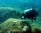
Biological monitoring, mapping, and scientific research are activities to track the condition of populations, communities, and habitat, and to understand the processes, stressors, and ecological interactions that affect that condition.
CMap
CMap Description
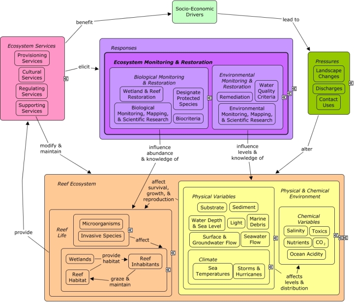
A change in the provision of ecosystem services, or a desire to improve provision of ecosystem services, may elicit responses to directly alter the reef ecosystem. Wetland or reef restoration may include repairing damaged individuals, or replenishing degraded reefs or wetlands with nursery-grown individuals. Remediation activities can be implemented to physical remove sediment, reduce levels of pollution, or remove marine debris. Water quality criteria can be used to set the maximum desirable levels of contaminants in coastal waters; biological criteria described the desired biological condition. Additional responses may need to be enacted to ensure that water quality criteria and biocriteria, once established, are achieved and maintained. Monitoring, mapping, and scientific research can be used to better understand changes in condition, bio-physical processes, and interactions among species, and how they may be impacted by various stressors or potential decisions. A healthy functioning reef ecosystem, beyond its existence or cultural value, is essential for a number of ecosystem goods and services, including shoreline protection, fishing, and recreational opportunities.Citations
| Citation | Year | Study Location | Study Type | Database Topics |
|---|---|---|---|---|
| Anderson, TJ; Nichol, SL; Syms, C; Przeslawski, R; Harris, PT. 2011. Deep-sea bio-physical variables as surrogates for biological assemblages, an example from the Lord Howe Rise. Deep-Sea Research Part II: Topical Studies in Oceanography 58:979-991. | 2011 | US Pacific & Hawaii | GIS & Maps; Decision Support Frameworks & Tools | Biological Monitoring, Mapping, & Scientific Research; Echinoderms; Environmental Monitoring, Mapping, & Scientific Research; Physical Variables; Sediment; Sponges; Water Depth & Sea Level |
| Brodie, JE; Devlin, M; Haynes, D; Waterhouse, J. 2011. Assessment of the eutrophication status of the Great Barrier Reef lagoon (Australia). Biogeochemistry 106:281-302. | 2011 | Australia; Europe | Field Study & Monitoring | Agriculture; Biological Monitoring, Mapping, & Scientific Research; Chemical Use Regulations; Climate; Discharges; Fertilizer & Pesticide Use; Funding & Donations; Funding & Incentives; Nutrients; Octocoral; Plankton; Seagrasses; Seastars; Sediment; Stony Coral; Surface & Groundwater Flow |
| Hitt, S; Pittman, SJ; Nemeth, RS. 2011. Diel movements of fishes linked to benthic seascape structure in a Caribbean coral reef ecosystem. Marine Ecology Progress Series 427:275-291. | 2011 | South & Central America; Caribbean | GIS & Maps; Decision Support Frameworks & Tools | Biological Monitoring, Mapping, & Scientific Research; Fish; Mangroves; Marine Protected Areas; Piscivorous Fish; Seagrasses; Sediment |
| Howell, KL; Holt, R; Endrino, IP; Stewart, H. 2011. When the species is also a habitat: Comparing the predictively modelled distributions of Lophelia pertusa and the reef habitat it forms. Biological Conservation 144:2656-2665. | 2011 | US East Coast (NC, SC, GA) | Model; Index or Indicator; GIS & Maps | Biological Monitoring, Mapping, & Scientific Research; Complex Habitat & Resources; Marine Protected Areas; Octocoral; Substrate |
| Huang, Z; Brooke, BP; Harris, PT. 2011. A new approach to mapping marine benthic habitats using physical environmental data. Continental Shelf Research 31:S4-S16. | 2011 | Australia; Spain | GIS & Maps | Biological Monitoring, Mapping, & Scientific Research; Environmental Monitoring, Mapping, & Scientific Research; Nutrients; Sediment |
| Neto, CCM; Cioffi, MB; Bertollo, LAC; Molina, WF. 2011. Extensive chromosomal homologies and evidence of karyotypic stasis in Atlantic grunts of the genus Haemulon (Perciformes). Journal of Experimental Marine Biology and Ecology 401:75-79. | 2011 | US East Coast (NC, SC, GA) | GIS & Maps | Biological Monitoring, Mapping, & Scientific Research; Fish |
| Oigman-Pszczol, SS; Creed, JC. 2011. Can patterns in benthic communities be explained by an environmental pressure index? Marine Pollution Bulletin 62:2181-2189. | 2011 | US East Coast (NC, SC, GA) | Field Study & Monitoring; Index or Indicator | Biological Monitoring, Mapping, & Scientific Research; Environmental Monitoring, Mapping, & Scientific Research; Stony Coral |
| Plaisance, L; Caley, MJ; Brainard, RE; Knowlton, N. 2011. The Diversity of Coral Reefs: What Are We Missing? PLoS One 6. | 2011 | Global; South & Central America; US Pacific & Hawaii; Caribbean | Field Study & Monitoring | Biological Monitoring, Mapping, & Scientific Research; Climate; Stony Coral |
| Schneider, K; Silverman, J; Woolsey, E; Eriksson, H; Byrne, M; Caldeira, K. 2011. Potential influence of sea cucumbers on coral reef CaCO(3) budget: A case study at One Tree Reef. Journal Of Geophysical Research-biogeosciences 116. | 2011 | Cuba | Field Study & Monitoring | Apex Fish Predators; Biological Monitoring, Mapping, & Scientific Research; Calcium Carbonate Deposition; Climate; Echinoderms; Ocean Acidity; Sediment; Skeletal Coral |
| Storlazzi, CD; Fregoso, TA; Golden, NE; Finlayson, DP. 2011. Sediment dynamics and the burial and exhumation of bedrock reefs along an emergent coastline as elucidated by repetitive sonar surveys: Northern Monterey Bay, CA. Marine Geology 289:46-59. | 2011 | US Pacific & Hawaii; Pacific Ocean | Model; GIS & Maps | Biological Monitoring, Mapping, & Scientific Research; Complex Habitat & Resources; Environmental Monitoring, Mapping, & Scientific Research; Sediment; Storms & Hurricanes; Surface & Groundwater Flow; Water Depth & Sea Level |
| van Rein, H; Brown, CJ; Quinn, R; Breen, J; Schoeman, D. 2011. An evaluation of acoustic seabed classification techniques for marine biotope monitoring over broad-scales (> 1 km(2)) and meso-scales (10 m(2)-1 km(2)). Estuarine Coastal and Shelf Science 93:336-349. | 2011 | Field Study & Monitoring; GIS & Maps; Decision Support Frameworks & Tools | Biological Monitoring, Mapping, & Scientific Research; Seagrasses | |
| Van Rein, H; Brown, CJ; Schoeman, DS; Quinn, R; Breen, J. 2011. Fixed-station monitoring of a harbour wall community: the utility of low-cost photomosaics and scuba on hard-substrata. Aquatic Conservation: Marine and Freshwater Ecosystems 21:690-703. | 2011 | US Pacific & Hawaii; Cuba | Field Study & Monitoring | Algae; Biological Monitoring, Mapping, & Scientific Research; Encrusting Sponges; Sponges |
| Blaustein< R. J. 2010. High-seas biodiversity and genetic resources: science and policy questions. Bioscience 60:408-413. | 2010 | Global | Biochemical & Genetic Resources; Biological Monitoring, Mapping, & Scientific Research; Scientific Research | |
| Callaway, R., N. Desroy, S. F. Dubois, J. Fournier, M. Frost, L. Godet, V. J. Hendrick, and M. Rabaut. 2010. Ephemeral Bio-engineers or Reef-building Polychaetes: How Stable are Aggregations of the Tube Worm Lanice conchilega (Pallas, 1766)? Integrative And Comparative Biology 50:237-250. | 2010 | Europe; France | Field Study & Monitoring | Biological Monitoring, Mapping, & Scientific Research; Environmental Monitoring, Mapping, & Scientific Research; Marine Worms; Sediment |
| Chu, J. W. F. and S. P. Leys. 2010. High resolution mapping of community structure in three glass sponge reefs (Porifera, Hexactinellida). Marine Ecology Progress Series 417:97-U120. | 2010 | US Pacific & Hawaii | GIS & Maps | Biological Monitoring, Mapping, & Scientific Research; Fish; Molluscs; Sponges |
| Comprehensive Everglades Restoration Plan. 2010. Comprehensive Everglades Restoration Plan: 2009 System Status Report. | 2010 | Florida | Field Study & Monitoring; Index or Indicator | Algae; Apex Fish Predators; Biological Monitoring, Mapping, & Scientific Research; Chemical Use Regulations; Climate; Fertilizer & Pesticide Use; Infrastructure; Lobster, Crab, & Shrimp; Non-point Source Runoff; Nutrients; Pathogens; Salinity; Seawater Flow; Sediment; Storms & Hurricanes; Surface & Groundwater Flow; Water Depth & Sea Level; Wetlands |
| de Bello, F., S. Lavorel, S. Diaz, R. Harrington, J. H. C. Cornelissen, R. D. Bardgett, M. P. Berg, P. Cipriotti, C. K. Feld, D. Hering, P. M. da Silva, S. G. Potts, L. Sandin, J. P. Sousa, J. Storkey, D. A. Wardle, and P. A. Harrison. 2010. Towards an assessment of multiple ecosystem processes and services via functional traits. Biodiversity and Conservation 19:2873-2893. | 2010 | Review; Field Study & Monitoring; Index or Indicator | Biological Monitoring, Mapping, & Scientific Research; Invertebrates; Nutrients | |
| Feld, C. K., J. P. Sousa, P. M. da Silva, and T. P. Dawson. 2010. Indicators for biodiversity and ecosystem services: towards an improved framework for ecosystems assessment. Biodiversity and Conservation 19:2895-2919. | 2010 | Global; Europe | Field Study & Monitoring; Index or Indicator; Remote Sensing | Biological Monitoring, Mapping, & Scientific Research; Surface & Groundwater Flow |
| Lauzon-Guay, J. S. and R. E. Scheibling. 2010. Spatial dynamics, ecological thresholds and phase shifts: modelling grazer aggregation and gap formation in kelp beds. Marine Ecology Progress Series 403:29-41. | 2010 | US East Coast (NC, SC, GA) | Field Study & Monitoring; Model; Decision Support Frameworks & Tools | Biological Monitoring, Mapping, & Scientific Research; Sea Urchins |
| Pittman, S. J., C. F. G. Jeffrey, R. Clark, K. Woody, B. D. Herlach, C. Caldow, M. E. Monaco, and R. Appledoorn. 2010. Coral reef ecosystems of Reserva Natural de La Parguera (Puerto Rico): spatial and temporal patterns in fish and benthic communities (2001-2007). National Oceanic and Atmospheric Administration, Silver Spring, MD. | 2010 | South & Central America; Puerto Rico; Caribbean | Field Study & Monitoring | Biological Monitoring, Mapping, & Scientific Research; Boating Activities; Boating Regulations; Collaboration & Partnering; Dive, Snorkeling, & Swimming Tourism; Environmental Monitoring, Mapping, & Scientific Research; Fish; Fishing Sector; Landscape Conservation & Restoration; Mangroves; Marine Debris; Marine Protected Areas; Tourism & Recreation |
| Reopanichkul, P., R. W. Carter, S. Worachananant, and C. J. Crossland. 2010. Wastewater discharge degrades coastal waters and reef communities in southern Thailand. Marine Environmental Research 69:287-296. | 2010 | Study Location; Thailand | Field Study & Monitoring | Biological Monitoring, Mapping, & Scientific Research; Discharges; Non-point Source Runoff; Tourism & Recreation; Wastewater Discharge |
| Reza, M. I. H. and S. A. Abdullah. 2010. Regional Index of ecological integrity: a need for sustainable management of natural resources. Ecological Indicators 11:220-229. | 2010 | Field Study & Monitoring; Index or Indicator | Biological Monitoring, Mapping, & Scientific Research; Landscape Conservation & Restoration | |
| Schittone, J. 2010. Restoration and monitoring of a vessel grounding on a shallow reef in the Florida Keys. Revista de Biologia Tropical 58:151-161. | 2010 | Florida | Field Study & Monitoring; Index or Indicator | Anchoring & Vessel Grounding; Biological Monitoring, Mapping, & Scientific Research; Hydrocoral; Octocoral; Substrate |
| Semmens, B. X., P. J. Auster, M. J. Paddack. 2010. Using ecological null models to assess the potential for marine protected area networks to protect biodiversity. PLoS Biology 5:e8895.doi:10.1371/jourl.pone.0008895. | 2010 | South & Central America; Caribbean | Model; Decision Support Frameworks & Tools | Biological Monitoring, Mapping, & Scientific Research; Fish; Marine Protected Areas |
| Sofonia, J. J. and R. K. F. Unsworth. 2010. Development of water quality thresholds during dredging for the protection of benthic primary producer habitats. Journal of Environmental Monitoring 12:159-163. | 2010 | Field Study & Monitoring; Model | Biological Monitoring, Mapping, & Scientific Research; Dredging, Draining, & Filling; Light; Sediment | |
| U.S. Coral Reef Task Force. 2010. Coral reef local action strategies. Department of the Interior, Washington, DC. | 2010 | Florida | Artificial Habitat; Beaches & Nature Parks; Biological Monitoring, Mapping, & Scientific Research; Boating Activities; Dive, Snorkeling, & Swimming Tourism; Finfish Harvest; Scientific Research; Tourism & Recreation | |
| Vroom, P. S., C. A. Musburger, S. W. Cooper, J. E. Maragos, K. N. Page-Albins, and M. A. V. Timmers. 2010. Marine biological community baselines in unimpacted tropical ecosystems: spatial and temporal analysis of reefs at Howland and Baker Islands. Biodiversity and Conservation 19:797-812. | 2010 | US Pacific & Hawaii; Pacific Ocean; Baker Island; Howland Island | Field Study & Monitoring | Algae; Biological Monitoring, Mapping, & Scientific Research; Fish; Turf Algae |
| Wakefield, C. B., S. J. Newman, and B. W. Molony. 2010. Age-based demography and reproduction of hapuku, Polyprion oxygeneios, from the south coast of Western Australia: implications for management. ICES Journal of Marine Science 67:1164-1174. | 2010 | Australia | Field Study & Monitoring; Model | Biological Monitoring, Mapping, & Scientific Research; Finfish Harvest; Fishing Sector |
| Yasue, M., L. Kaufman, and A. C. J. Vincent. 2010. Assessing ecological changes in and around marine reserves using community perceptions and biological surveys. Aquatic Conservation: Marine and Freshwater Ecosystems 20:407-418. | 2010 | Philippines | Field Study & Monitoring | Biological Monitoring, Mapping, & Scientific Research; Collaboration & Partnering; Finfish Harvest; Fish; Marine Protected Areas |
| Zawada, D. G., G. A. Piniak, and C. J. Hearn. 2010. Topographic complexity and roughness of a tropical benthic seascape. Geophysical Research Letters 37:L14604. | 2010 | Field Study & Monitoring; Model | Biological Monitoring, Mapping, & Scientific Research; Nutrients; Seawater Flow; Stony Coral; Substrate | |
| 2009. Special issue featuring: ocean acidification - from ecological impacts to policy opportunities. Current 25:1-45. | 2009 | Global | Biological Monitoring, Mapping, & Scientific Research; Finfish Harvest; Fishing Sector; Ocean Acidity; Scientific Research | |
| Bradley, P., W. S. Fisher, H. Bell, W. Davis, V. Chan, C. LoBue, and W. Wiltse. 2009. Development and implementation of coral reef biocriteria in US jurisdictions. Environmental Monitoring and Assessment 150:43-51. | 2009 | Global; US Virgin Islands | Review; Field Study & Monitoring | Biocriteria; Biological Monitoring, Mapping, & Scientific Research; Climate; Environmental Monitoring, Mapping, & Scientific Research; Finfish Harvest; Physical & Chemical Water Quality Criteria; Physical Damage; Sea Temperatures; Shoreline Protection; Stony Coral; Tourism & Recreation |
| Bradley, P., W. S. Fisher, H. Bell, W. Davis, V. Chan, C. LoBue, W. Wiltse. 2009. Development and implementation of coral reef biocriteria in U.S. jurisdictions. Environmental Monitoring and Assessment 150:43-51. | 2009 | Global; US Virgin Islands | Review; Field Study & Monitoring | Biocriteria; Biological Monitoring, Mapping, & Scientific Research; Climate; Environmental Monitoring, Mapping, & Scientific Research; Finfish Harvest; Physical & Chemical Water Quality Criteria; Physical Damage; Sea Temperatures; Shoreline Protection; Stony Coral; Tourism & Recreation |
| de Freitas, D. M., S. Kininmonth, and S. Woodley. 2009. Linking science and management in the adoption of sensor network technology in the Great Barrier Reef coast, Australia. Computers, Environment and Urban Systems 33:111-121. | 2009 | Australia | Field Study & Monitoring | Biological Monitoring, Mapping, & Scientific Research; Environmental Monitoring, Mapping, & Scientific Research; Infrastructural Policies; Infrastructure; Light; Surface & Groundwater Flow |
| de Freitas, M. C., R. H. S. D. Vieira, and M. E. de Araujo. 2009. Impact of the Construction of the Harbor at Pecem (Ceara, Brazil) upon Reef Fish Communities in Tide Pools. Brazilian Archives of Biology and Technology 52:187-195. | 2009 | Field Study & Monitoring; Index or Indicator | Biological Monitoring, Mapping, & Scientific Research; Dredging, Draining, & Filling; Environmental Monitoring, Mapping, & Scientific Research; Fish; Ports & Harbors; Small Herbivorous Fish | |
| Diesing, M., R. Coggan, and K. Vanstaen. 2009. Widespread rocky reef occurrence in the central English Channel and the implications for predictive habitat mapping. Estuarine Coastal and Shelf Science 83:647-658. | 2009 | Europe; United Kingdom | Model; GIS & Maps | Biological Monitoring, Mapping, & Scientific Research; Sediment |
| Feld, C. K., R. M. da Silva, J. P. Sousa, F. de Bello, R. Bugter, U. Grandin, D. Hering, S. Lavorel, O. Mountford, I. Pardo, M. Partel, J. Rombke, L. Sandin, K. B. Jones, and P. Harrison. 2009. Indicators of biodiversity and ecosystem services: a synthesis across ecosystems and spatial scales. Oikos 118:1862-1871. | 2009 | Global | Review; Field Study & Monitoring; Index or Indicator | Biological Monitoring, Mapping, & Scientific Research; Supporting Services; Surface & Groundwater Flow; Wetlands |
| Georgiadis, M., G. Papatheodorou, E. Tzanatos, M. Geraga, A. Ramfos, C. Koutsikopoulos, and G. Ferentinos. 2009. Coralligene formations in the eastern Mediterranean Sea: Morphology, distribution, mapping and relation to fisheries in the southern Aegean Sea (Greece) based on high-resolution acoustics. Journal of Experimental Marine Biology and Ecology 368:44-58. | 2009 | GIS & Maps | Algae; Biological Monitoring, Mapping, & Scientific Research; Coralline Algae; Finfish Harvest; Fishing & Harvesting Management; Fishing Sector; Sediment; Special Use Permitting; Substrate; Trawling & Fishing Gear Damage | |
| Le Guilloux, E., K. Olu, J. F. Bourillet, B. Savoye, S. P. Iglesias, and M. Sibuet. 2009. First observations of deep-sea coral reefs along the Angola margin. Deep-Sea Research Part II: Topical Studies in Oceanography 56:2394-2403. | 2009 | GIS & Maps | Biological Monitoring, Mapping, & Scientific Research; Bivalves; Environmental Monitoring, Mapping, & Scientific Research; Fish; Sediment; Stony Coral | |
| Leopold, M., A. Cakacaka, S. Meo, J. Sikolia, and D. Lecchini. 2009. Evaluation of the effectiveness of three underwater reef fish monitoring methods in Fiji. Biodiversity and Conservation 16-Jan. | 2009 | US Pacific & Hawaii; Fiji | Field Study & Monitoring | Biological Monitoring, Mapping, & Scientific Research; Dive, Snorkeling, & Swimming Tourism; Environmental Monitoring, Mapping, & Scientific Research; Fish; Social Organizations |
| Nguyen, H. Y. T., O. Pedersen, K. Ikejima, K. Sunada, and S. Oishi. 2009. Using reefcheck monitoring database to develop the coral reef index of biological integrity. Journal of Fisheries and Aquatic Science 4:90-102. | 2009 | Field Study & Monitoring; Index or Indicator; Decision Support Frameworks & Tools | Algae; Biological Monitoring, Mapping, & Scientific Research; Finfish Harvest; Skeletal Coral; Small Boats; Stony Coral | |
| Notarbartolo-Di-Sciara, G., M. H. Hanafy, M. M. Fouda, A. Afifi, and M. Costa. 2009. Spinner dolphin (Stenella longirostris) resting habitat in Samadai Reef (Egypt, Red Sea) protected through tourism management. Journal of the Marine Biological Association of the United Kingdom 89:211-216. | 2009 | Egypt; United Kingdom | Field Study & Monitoring | Biological Monitoring, Mapping, & Scientific Research; Tourism & Recreation; Whales & Dolphins |
| Nowak, D., M. Florek, J. Nowak, W. Kwiatek, J. Lekki, P. Chevallier, A. Hacura, R. Wrzalik, B. Ben-Nissan, R. Van Grieken, and A. Kuczumow. 2009. Morphology and the chemical make-up of the inorganic components of black corals. Materials Science and Engineering C 29:1029-1038. | 2009 | GIS & Maps | Biological Monitoring, Mapping, & Scientific Research | |
| Pande, A. and J. P. A. Gardner. 2009. A baseline biological survey of the proposed Taputeranga Marine Reserve (Wellington, New Zealand): spatial and temporal variability along a natural environmental gradient. Aquatic Conservation: Marine and Freshwater Ecosystems 19:237-248. | 2009 | Field Study & Monitoring; Index or Indicator | Biological Monitoring, Mapping, & Scientific Research; Environmental Monitoring, Mapping, & Scientific Research; Fish; Fishing Sector; Invertebrates | |
| Pietri, D., P. Christie, R. B. Pollnac, R. Diaz, and A. Sabonsolin. 2009. Information Diffusion in Two Marine Protected Area Networks in the Central Visayas Region, Philippines. Coastal Management 37:331-348. | 2009 | Philippines | Field Study & Monitoring | Biological Monitoring, Mapping, & Scientific Research; Environmental Education & Outreach; Environmental Monitoring, Mapping, & Scientific Research; Fish; Fishing Sector; Infrastructure; Marine Protected Areas |
| Smith, A. M. 2009. Bryozoans as southern sentinels of ocean acidification: A major role for a minor phylum. Marine and Freshwater Research 60:475-482. | 2009 | Global; Australia | Field Study & Monitoring; Model | Biological Monitoring, Mapping, & Scientific Research; CO2; Environmental Monitoring, Mapping, & Scientific Research; Ocean Acidity; Sediment; Surface & Groundwater Flow |
| Sunagawa, S., E. C. Wilson, M. Thaler, M. L. Smith, C. Caruso, J. R. Pringle, V. M. Weis, M. Medina, and J. A. Schwarz. 2009. Generation and analysis of transcriptomic resources for a model system on the rise: the sea anemone Aiptasia pallida and its dinoflagellate endosymbiont. BMC Genomics 10:258. | 2009 | Field Study & Monitoring; Model; Decision Support Frameworks & Tools | Algae; Anemones & Zooanthids; Biological Monitoring, Mapping, & Scientific Research | |
| Teplitski, M. and K. Ritchie. 2009. How feasible is the biological control of coral diseases? Trends in Ecology and Evolution 24:378-385. | 2009 | Field Study & Monitoring; Lab Study; Index or Indicator; Decision Support Frameworks & Tools | Biological Monitoring, Mapping, & Scientific Research; Microorganisms; Pathogens | |
| Alkendi, M. Y. and M. Chandler. 2008. A successful stakeholder partnership - The Dolphin Energy experience coral reef habitats of the Arabian Gulf. Pages 2039-2047 in Society of Petroleum Engineers - 9th International Conference on Health, Safety and Environment in Oil and Gas Exploration and Production 2008 - \In Search of Sustainable Excellence\"". | 2008 | Global; Qatar | GIS & Maps | Biological Monitoring, Mapping, & Scientific Research; Collaboration & Partnering; Complex Habitat & Resources; Cultural Policies; Environmental Monitoring, Mapping, & Scientific Research; Oil & Gas Research & Exploration; Resource Use Management; Whales & Dolphins |
| Balmford, A., A. S. L. Rodrigues, M. Walpole, P. ten Brink, M. Kettunen, L. Braat, and R. de Groot. 2008. The economics of biodiversity and ecosystems: scoping the science. European Commission, Cambridge, UK. | 2008 | Global | Review; GIS & Maps | Aquaculture; Biological Monitoring, Mapping, & Scientific Research; Biomedical Research Policies; Climate; Fishing Sector; Forestry; Monetary Valuation |
| Bell, J. J. 2008. The functional roles of marine sponges. Estuarine Coastal and Shelf Science 79:341-353. | 2008 | Review; Field Study & Monitoring; Decision Support Frameworks & Tools | Biological Monitoring, Mapping, & Scientific Research; Carbon Storage & Cycling; Nutrients; Primary Production; Sponges; Substrate | |
| Bertels, L., T. Vanderstraete, S. Van Coillie, E. Knaeps, S. Sterckx, R. Goossens, and B. Deronde. 2008. Mapping of coral reefs using hyperspectral CASI data; a case study: Fordata, Tanimbar, Indonesia. International Journal of Remote Sensing 29:2359-2391. | 2008 | Indonesia | Field Study & Monitoring; Model; GIS & Maps; Remote Sensing | Biological Monitoring, Mapping, & Scientific Research |
| Bradley, P., W. Davis, W. Fisher, H. Bell, V. Chan, C. LoBue, and W. Wiltse. 2008. Biological criteria for protection of U.S. coral reefs. Pages 1078-1082 in Proceedings of the 11th International Coral Reef Symposium. Ft. Lauderdale, Florida. | 2008 | Field Study & Monitoring; Decision Support Frameworks & Tools | Biocriteria; Biological Monitoring, Mapping, & Scientific Research; Collaboration & Partnering; Designated Uses; Environmental Monitoring, Mapping, & Scientific Research; Physical & Chemical Water Quality Criteria | |
| Brown, C. J. and J. S. Collier. 2008. Mapping benthic habitat in regions of gradational substrata: An automated approach utilising geophysical, geological, and biological relationships. Estuarine Coastal and Shelf Science 78:203-214. | 2008 | Europe | GIS & Maps | Artificial Habitat; Biological Monitoring, Mapping, & Scientific Research; Environmental Monitoring, Mapping, & Scientific Research; Sediment |
| Cardona-Maldonado, M. A. 2008. Assessment of coral reef community structure using water optical properties. Masters Thesis. University of Puerto Rico, Mayaguez (Puerto Rico). | 2008 | Field Study & Monitoring; Model; Index or Indicator; Remote Sensing; Decision Support Frameworks & Tools | Algae; Biological Monitoring, Mapping, & Scientific Research; Complex Habitat & Resources; Environmental Monitoring, Mapping, & Scientific Research; Light; Nutrients; Octocoral; Pathogens; Sediment; Sponges; Substrate | |
| Chancerelle, Y. 2008. Coral reefs of Wallis and Futuna: Biological monitoring, health and future [Les recifs coralliens de Wallis et Futuna: Suivi biologique, etat de sante et perspectives d'avenir]. Revue d'Ecologie (La Terre et la Vie) 63:133-143. | 2008 | US Pacific & Hawaii; Australia; Pacific Ocean; Fiji; Samoa; Europe | Field Study & Monitoring | Biological Monitoring, Mapping, & Scientific Research; Finfish Harvest |
| Isozaki, Y., J. Yao, Z. Ji, M. Saitoh, N. Kobayashi, and H. Sakai. 2008. Rapid sea-level change in the Late Guadalupian (Permian) on the Tethyan side of South China: Litho- and biostratigraphy of the Chaotian section in Sichuan. Pages 344-353 in Proceedings of the Japan Academy Series B: Physical and Biological Sciences. | 2008 | Global; Japan; China | Field Study & Monitoring; GIS & Maps | Biological Monitoring, Mapping, & Scientific Research; Environmental Monitoring, Mapping, & Scientific Research |
| Jianyu, C., M. Zhihua, and H. Xianqiang. 2008. Geomorphological diversity of Dong-Sha Atoll based on spectrum and texture analysis in high resolution remote sensing imagery. Proceedings of SPIE - The International Society for Optical Engineering 7150. | 2008 | China | GIS & Maps; Remote Sensing; Decision Support Frameworks & Tools | Biological Monitoring, Mapping, & Scientific Research; Shoreline Protection |
| Lammers, M. O., R. E. Brainard, W. W. L. Au, T. A. Mooney, and K. B. Wong. 2008. An ecological acoustic recorder (EAR) for long-term monitoring of biological and anthropogenic sounds on coral reefs and other marine habitats. Journal of the Acoustical Society of America 123:1720-1728. | 2008 | Field Study & Monitoring | Biological Monitoring, Mapping, & Scientific Research; Fish; Lobster, Crab, & Shrimp; Whales & Dolphins | |
| Lindenbaum, C., J. D. Bennell, E. I. S. Rees, D. Mcclean, W. Cook, A. J. Wheeler, and W. G. Sanderson. 2008. Small-scale variation within a Modiolus modiolus (Mollusca: Bivalvia) reef in the Irish Sea: I. Seabed mapping and reef morphology. Journal of the Marine Biological Association of the United Kingdom 88:133-141. | 2008 | United Kingdom | Field Study & Monitoring; GIS & Maps | Biological Monitoring, Mapping, & Scientific Research; Molluscs |
| Metian, M. and M. Warnau. 2008. The tropical brown alga Lobophora variegata (Lamouroux) womersley: A prospective bioindicator for Ag contamination in tropical coastal waters. Bulletin of Environmental Contamination and Toxicology 81:455-458. | 2008 | Field Study & Monitoring; Index or Indicator | Biological Monitoring, Mapping, & Scientific Research; Environmental Monitoring, Mapping, & Scientific Research; Fleshy Macroalgae | |
| Mohammed, S. W. C. and S. E. Coppard. 2008. Ecology and distribution of soft-sediment benthic communities off Viti Levu (Fiji). Marine Ecology Progress Series 371:91-107. | 2008 | Australia; New Caledonia; Fiji | Field Study & Monitoring; Index or Indicator | Biological Monitoring, Mapping, & Scientific Research; Climate; Echinoderms; Environmental Monitoring, Mapping, & Scientific Research; Marine Worms; Molluscs; Sediment; Surface & Groundwater Flow |
| Monk, J., D. Ierodiaconou, A. Bellgrove, and L. Laurenson. 2008. Using community-based monitoring with GIS to create habitat maps for a marine protected area in Australia. Journal of the Marine Biological Association of the United Kingdom 88:865-871. | 2008 | Global; Australia; Cuba; United Kingdom | Field Study & Monitoring; GIS & Maps | Biological Monitoring, Mapping, & Scientific Research; Marine Protected Areas; Social Organizations |
| Monteiro-Neto, C., R. A. Tubino, L. E. S. Moraes, J. P. De Mendonca Neto, G. V. Esteves, and W. L. Fortes. 2008. Associations of fishes in the coastal region of Itaipu, Niteroi [Associacões de peixes na região costeira de Itaipu, Niteroi, RJ]. Iheringia - Serie Zoologia 98:50-59. | 2008 | Field Study & Monitoring | Biological Monitoring, Mapping, & Scientific Research; Fish; Fishing Sector | |
| Morley, D. M., R. L. Sherman, L. K. B. Jordan, K. W. Banks, T. P. Quinn, and R. E. Spieler. 2008. Environmental enhancement gone awry: Characterization of an artificial reef constructed from waste vehicle tires. Pages 73-87 in WIT Transactions on the Built Environment. | 2008 | Florida | Field Study & Monitoring | Artificial Habitat; Biological Monitoring, Mapping, & Scientific Research; Environmental Monitoring, Mapping, & Scientific Research; Fish; Substrate |
| National Oceanic and Atmospheric Administration (NOAA). 2008. Detailed methods for characterization and monitoring of coral reef ecosystems and associated biological communities. NOAA Center for Coastal Monitoring and Assessment. | 2008 | Florida; US Virgin Islands | Field Study & Monitoring | Biological Monitoring, Mapping, & Scientific Research; Fish; Fishing Sector; Mangroves |
| Prada, M. C., R. S. Appeldoorn, and J. A. Rivera. 2008. Improving coral reef habitat mapping of the Puerto Rico insular shelf using side scan sonar. Marine Geodesy 31:49-73. | 2008 | Puerto Rico | GIS & Maps | Biological Monitoring, Mapping, & Scientific Research; Complex Habitat & Resources; Environmental Monitoring, Mapping, & Scientific Research; Sediment |
| Reitzel, A. M., J. C. Sullivan, N. Traylor-Knowles, and J. R. Finnerty. 2008. Genomic survey of candidate stress-response genes in the estuarine anemone Nematostella vectensis. Biological Bulletin 214:233-254. | 2008 | Field Study & Monitoring; Lab Study | Anemones & Zooanthids; Biological Monitoring, Mapping, & Scientific Research; Coastal Development; Environmental Monitoring, Mapping, & Scientific Research; Light; Nutrients; Pathogens; Salinity; Stony Coral | |
| Sanderson, W. G., R. H. F. Holt, L. Kay, K. Ramsay, J. Perrins, A. J. Mcmath, and E. I. S. Rees. 2008. Small-scale variation within a Modiolus modiolus (Mollusca: Bivalvia) reef in the Irish Sea. II. Epifauna recorded by divers and cameras. Journal of the Marine Biological Association of the United Kingdom 88:143-149. | 2008 | United Kingdom | Field Study & Monitoring; Index or Indicator | Biological Monitoring, Mapping, & Scientific Research; Environmental Monitoring, Mapping, & Scientific Research; Finfish Harvest; Molluscs; Sediment |
| Torrents, O., E. Tambutte, N. Caminiti, and J. Garrabou. 2008. Upper thermal thresholds of shallow vs. deep populations of the precious Mediterranean red coral Corallium rubrum (L.): Assessing the potential effects of warming in the NW Mediterranean. Journal of Experimental Marine Biology and Ecology 357:19-Jul. | 2008 | Global; France | Field Study & Monitoring; Model; Decision Support Frameworks & Tools | Biological Monitoring, Mapping, & Scientific Research; Climate |
| Wang, Y.-S., Z.-P. Lou, C.-C. Sun, and S. Sun. 2008. Ecological environment changes in Daya Bay, China, from 1982 to 2004. Marine Pollution Bulletin 56:1871-1879. | 2008 | China | Field Study & Monitoring | Biological Monitoring, Mapping, & Scientific Research; Environmental Monitoring, Mapping, & Scientific Research; Mangroves; Plankton; Shoreline Protection |
| Aswani, S., S. Albert, A. Sabetian, and T. Furusawa. 2007. Customary management as precautionary and adaptive principles for protecting coral reefs in Oceania. Coral Reefs 26:1009-1021. | 2007 | Field Study & Monitoring | Biological Monitoring, Mapping, & Scientific Research; Marine Protected Areas; Resource Use Management | |
| Bandyopadhyay, S., A. Bahuguna, and S. Sharma. 2007. Development of neural network algorithm to classify coral reefs through satellite data. Pages 7879-7887 in International Astronautical Federation - 58th International Astronautical Congress 2007. | 2007 | GIS & Maps; Remote Sensing; Decision Support Frameworks & Tools | Biological Monitoring, Mapping, & Scientific Research; Coal Mining | |
| Beaman, R. J. and P. T. Harris. 2007. Geophysical variables as predictors of megabenthos assemblages from the Northern Great Barrier Reef, Australia. Special Paper - Geological Association of Canada 247-263. | 2007 | Australia | Model; GIS & Maps; Decision Support Frameworks & Tools | Biological Monitoring, Mapping, & Scientific Research; Marine Protected Areas; Physical Variables; Sediment; Substrate |
| Bondarenko, O., S. Kininmonth, and M. Kingsford. 2007. Coral reef sensor network deployment for collecting real time 3-D temperature data with correlation to plankton assemblages. Pages 204-209 in 2007 International Conference on Sensor Technologies and Applications, SENSORCOMM 2007, Proceedings. | 2007 | Australia | Field Study & Monitoring | Biological Monitoring, Mapping, & Scientific Research; Nutrients; Plankton |
| Bondarenko, O., S. Kininmonth, and M. Kingsford. 2007. Underwater sensor networks, oceanography and plankton assemblages. Pages 657-662 in Proceedings of the 2007 International Conference on Intelligent Sensors, Sensor Networks and Information Processing, ISSNIP. | 2007 | Australia | Field Study & Monitoring | Biological Monitoring, Mapping, & Scientific Research; Nutrients; Plankton |
| Bryan, T. L. and A. Metaxas. 2007. Predicting suitable habitat for deep-water gorgonian corals on the Atlantic and Pacific Continental Margins of North America. Marine Ecology Progress Series 330:113-126. | 2007 | US Pacific & Hawaii; US East Coast (NC, SC, GA); Columbia | Model; GIS & Maps | Biological Monitoring, Mapping, & Scientific Research; Environmental Monitoring, Mapping, & Scientific Research; Octocoral; Resource Use Management |
| Camilli, R., O. Pizarro, and L. Camilli. 2007. Rapid swath mapping of reef ecology and associated water column chemistry in the Gulf of Chiriqui, Panama. in Oceans Conference Record (IEEE). | 2007 | US Pacific & Hawaii; Panama; Pacific Ocean | GIS & Maps | Biological Monitoring, Mapping, & Scientific Research; Complex Habitat & Resources; Primary Production |
| Clode, P. L., R. A. Stern, and A. T. Marshall. 2007. Subcellular imaging of isotopically labeled carbon compounds in a biological sample by ion microprobe (NanoSIMS). Microscopy Research and Technique 70:220-229. | 2007 | GIS & Maps | Biological Monitoring, Mapping, & Scientific Research | |
| Dambacher, J. M., D. T. Brewer, D. M. Dennis, M. Macintyre, and S. Foale. 2007. Qualitative modelling of gold mine impacts on Lihir Island's socioeconomic system and reef-edge fish community. Environmental Science and Technology 41:555-562. | 2007 | Papua New Guinea | Field Study & Monitoring; Model | Algae; Biological Monitoring, Mapping, & Scientific Research; Finfish Harvest; Fish; Fishing Sector; Mineral, Rock, & Metal Mining; Sediment |
| Fishe, W. S., W. P. Davis, R. L. Quarles, J. Patrick, J. G. Campbell, P. S. Harris, B. L. Hemmer, and M. Parsons. 2007. Characterizing coral condition using estimates of three-dimensional colony surface area. Environmental Monitoring and Assessment 125:347-360. | 2007 | Florida | Field Study & Monitoring | Biological Monitoring, Mapping, & Scientific Research; Calcium Carbonate Deposition; Fishing Sector; Infrastructure; Primary Production; Shoreline Protection; Stony Coral; Tourism & Recreation; Valuation |
| Gupta, L. P., A. Suzuki, and H. Kawahata. 2007. Endolithic aspartic acid as a proxy of fluctuations in coral growth. Journal of Geophysical Research G: Biogeosciences 112. | 2007 | Field Study & Monitoring; Index or Indicator | Biological Monitoring, Mapping, & Scientific Research; Environmental Monitoring, Mapping, & Scientific Research | |
| Kuffner, I. B., J. C. Brock, R. Grober-Dunsmore, V. E. Bonito, T. D. Hickey, and C. W. Wright. 2007. Relationships between reef fish communities and remotely sensed rugosity measurements in Biscayne National Park, Florida, USA. 78:71-82. | 2007 | Florida | Model; GIS & Maps; Remote Sensing; Decision Support Frameworks & Tools | Biological Monitoring, Mapping, & Scientific Research; Complex Habitat & Resources; Fish; Marine Protected Areas; Physical Variables |
| Lin, H.-J., C.-Y. Wu, S.-J. Kao, W.-Y. Kao, and P.-J. Meng. 2007. Mapping anthropogenic nitrogen through point sources in coral reefs using δ15N in macroalgae. Marine Ecology Progress Series 335:95-109. | 2007 | Taiwan | Index or Indicator; GIS & Maps | Algae; Biological Monitoring, Mapping, & Scientific Research; Nutrients; Point Source Discharges; Tourism & Recreation |
| McLeod, I., T. D. Skewes, S. R. Gordon, and C. R. Pitcher. 2007. A method for seabed habitat mapping: Integrating acoustic information with biogeophysical observations: Case study - Scott Reef. Special Paper - Geological Association of Canada 309-317. | 2007 | Australia | Index or Indicator; GIS & Maps | Biological Monitoring, Mapping, & Scientific Research; Substrate; Surface & Groundwater Flow |
| National Oceanic and Atmospheric Administration. 2007. National Artificial Reef Plan: Guidelines for Siting, Construction, Development, and Assessment of Artificial Reefs. US Department of Commerce. | 2007 | Field Study & Monitoring; Decision Support Frameworks & Tools | Artificial Habitat; Banks, Credit, & Securities; Biological Monitoring, Mapping, & Scientific Research; Construction Codes & Projects; Environmental Monitoring, Mapping, & Scientific Research; Finfish Harvest; Fish; Fishing & Harvesting Management; Fishing Sector; Military; Mitigation; Schools & Colleges | |
| Philpott, S. L., J. W. C. James, C. V. L. Poulton, E. J. Bee, C. Graham, and L. Jones. 2007. The use of geological data in developing a framework for the mapping of marine habitats on a national scale in English waters. Special Paper - Geological Association of Canada 211-218. | 2007 | Europe | GIS & Maps | Biological Monitoring, Mapping, & Scientific Research; Environmental Monitoring, Mapping, & Scientific Research; Sediment |
| Shears, N. T. 2007. Biogeography, community structure and biological habitat types of subtidal reefs on the South Island West Coast, New Zealand. Science for Conservation Jan-53. | 2007 | GIS & Maps | Algae; Biological Monitoring, Mapping, & Scientific Research; Complex Habitat & Resources; Environmental Monitoring, Mapping, & Scientific Research; Invertebrates; Marine Protected Areas; Sea Urchins; Sponges | |
| United Nations (UN). 2007. An update on marine genetic resources: scientific research, commercial uses and a database on marine bioprospecting. United Nations informal Consultative Process on Oceans and the Law of the Sea, New York. | 2007 | Biochemical & Genetic Resources; Biological Monitoring, Mapping, & Scientific Research; Marine Protected Areas; Pharmaceuticals & Cosmetics; Pharmaceuticals & Cosmetics Sources; Scientific Research; Special Use Permitting | ||
| Velez-Reyes, M., S. Rosario-Torres, J. A. Goodman, E. M. Alvira, and A. Castrodad. 2007. Hyperspectral image unmixing over benthic habitats. Proceedings of SPIE - The International Society for Optical Engineering 6565. | 2007 | US Pacific & Hawaii | Model; GIS & Maps; Remote Sensing | Algae; Biological Monitoring, Mapping, & Scientific Research; Environmental Monitoring, Mapping, & Scientific Research |
| Wells, S., N. Burgess, and A. Ngusaru. 2007. Towards the 2012 marine protected area targets in Eastern Africa. Ocean and Coastal Management 50:67-83. | 2007 | Global; Kenya; Tanzania; Mozambique | Field Study & Monitoring | Biological Monitoring, Mapping, & Scientific Research; Finfish Harvest; Marine Protected Areas |
| Wheeler, A. J., A. Beyer, A. Freiwald, H. de Haas, V. A. I. Huvenne, M. Kozachenko, K. Olu-Le Roy, and J. Opderbecke. 2007. Morphology and environment of cold-water coral carbonate mounds on the NW European margin. International Journal of Earth Sciences 96:37-56. | 2007 | Europe | GIS & Maps | Biological Monitoring, Mapping, & Scientific Research; Environmental Monitoring, Mapping, & Scientific Research |
| Xu, D.-X. and G.-X. Zhang. 2007. Impact of human activities on coastal wetlands in China. Wetland Science 5:282-298. | 2007 | China | Agriculture; Biological Monitoring, Mapping, & Scientific Research; Environmental Monitoring, Mapping, & Scientific Research; Mangroves; Nutrients; Scientific Research; Surface & Groundwater Flow; Wetlands | |
| Claudet, J., D. Pelletier, J.-Y. Jouvenel, F. Bachet, and R. Galzin. 2006. Assessing the effects of marine protected area (MPA) on a reef fish assemblage in a northwestern Mediterranean marine reserve: Identifying community-based indicators. Biological Conservation 130:349-369. | 2006 | Field Study & Monitoring; Model; Index or Indicator; Decision Support Frameworks & Tools | Biological Monitoring, Mapping, & Scientific Research; Finfish Harvest; Fish; Fishing Sector; Marine Protected Areas | |
| Davies, S. P. and S. K. Jackson. 2006. The biological condtion gradient: a descriptive model for interpreting change in aquatic ecosystems. Ecological Applications 16:1251-1266. | 2006 | Field Study & Monitoring; Model; Index or Indicator | Biological Monitoring, Mapping, & Scientific Research; Environmental Monitoring, Mapping, & Scientific Research; Fish; Invertebrates | |
| Harding, S., J. Comley, and P. Raines. 2006. Baseline data analysis as a tool for predicting the conservation value of tropical coastal habitats in the Indo-Pacific. Ocean and Coastal Management 49:696-705. | 2006 | South & Central America; US Pacific & Hawaii; Caribbean; United Kingdom | Index or Indicator; GIS & Maps; Decision Support Frameworks & Tools | Biological Monitoring, Mapping, & Scientific Research; Environmental Monitoring, Mapping, & Scientific Research; Fish; Marine Protected Areas; Resource Use Management; Social Organizations |
| Kelley, C., R. Moffitt, and J. R. Smith. 2006. Mega- to micro-scale classification and description of bottomfish essential fish habitat on four banks in the Northwestern Hawaiian Islands. Atoll Research Bulletin 319-332. | 2006 | US Pacific & Hawaii | GIS & Maps | Biological Monitoring, Mapping, & Scientific Research; Echinoderms; Finfish Harvest; Fish; Molluscs; Sediment; Sponges; Substrate; Tunicates |
| Kenyon, J. C., P. S. Vroom, K. N. Page, M. J. Dunlap, C. B. Wilkinson, and G. S. Aeby. 2006. Community structure of hermatypic corals at French Frigate Shoals, Northwestern Hawaiian Islands: Capacity for resistance and resilience to selective stressors. Pacific Science 60:153-175. | 2006 | US Pacific & Hawaii | Field Study & Monitoring | Biological Monitoring, Mapping, & Scientific Research; Pathogens; Seastars; Stony Coral |
| Reed, D. C., S. C. Schroeter, D. Huang, T. W. Anderson, and R. F. Ambrose. 2006. Quantitative assessment of different artificial reef designs in mitigating losses to kelp forest fishes. Bulletin of Marine Science 78:133-150. | 2006 | Field Study & Monitoring; Decision Support Frameworks & Tools | Artificial Habitat; Biological Monitoring, Mapping, & Scientific Research; Fish; Substrate | |
| Schleyer, M. H., J. M. Heikoop, and M. J. Risk. 2006. A benthic survey of Aliwal Shoal and assessment of the effects of a wood pulp effluent on the reef. Marine Pollution Bulletin 52:503-514. | 2006 | South Africa | Field Study & Monitoring | Algae; Biological Monitoring, Mapping, & Scientific Research; Discharges; Encrusting Sponges; Sponges |
| Toller, W. 2006. An investigation of anchor damage to the Frederiksted Reef System: Impacts to substrate, benthic communities, and reef fish assemblages. Disivision of Fish and Wildlife, Department of Planning and Natural Resources, Frederiksted, USVI. | 2006 | US Virgin Islands | Index or Indicator; GIS & Maps | Algae; Anchoring & Vessel Grounding; Biological Monitoring, Mapping, & Scientific Research; Calcareous Macroalgae; Commercial Fishing Boats; Complex Habitat & Resources; Fish; Fleshy Macroalgae; Skeletal Coral; Stony Coral; Substrate; Turf Algae |
| Aronson, R. B., W. F. Precht, T. J. T. Murdoch, and M. L. Robbart. 2005. Long-term persistence of coral assemblages on the Flower Garden Banks, Northwestern Gulf of Mexico: Implications for science and management. Gulf of Mexico Science 23:84-94. | 2005 | South & Central America; Florida; Caribbean; Mexico | Field Study & Monitoring | Biological Monitoring, Mapping, & Scientific Research; Environmental Monitoring, Mapping, & Scientific Research; Stony Coral |
| Bosman, C., R. Uken, and A. M. Smith. 2005. The bathymetry of the Aliwal Shoal, Scottburgh, South Africa. South African Journal of Science 101:255-257. | 2005 | South Africa | Model; GIS & Maps; Decision Support Frameworks & Tools | Biological Monitoring, Mapping, & Scientific Research; Construction Codes & Projects; Environmental Monitoring, Mapping, & Scientific Research; Marine Protected Areas |
| Bozec, Y.-M., M. Kulbicki, E. Chassot, and D. Gascuel. 2005. Trophic signature of coral reef fish assemblages: Towards a potential indicator of ecosystem disturbance. Aquatic Living Resource 18:103-109. | 2005 | New Caledonia | Field Study & Monitoring; Index or Indicator | Biological Monitoring, Mapping, & Scientific Research; Discharges; Environmental Monitoring, Mapping, & Scientific Research; Fish |
| Bums, K., J. MacPherson, J. Tierney, M. Stoelting, L. Yelle, and D. Jorissen. 2005. Sediment chemistry studies related to the 1986 Bahia las Minas (Panama) oil spill. Page 7605 in 2005 International Oil Spill Conference, IOSC 2005. | 2005 | South & Central America; Panama; Caribbean | Field Study & Monitoring | Biological Monitoring, Mapping, & Scientific Research; Environmental Monitoring, Mapping, & Scientific Research; Mangroves; Petroleum Spills; Seagrasses; Sediment; Storms & Hurricanes |
| Clua, E., B. Beliaeff, C. Chauvet, G. David, J. Ferraris, M. Kronen, M. Kulbicki, P. Labrosse, Y. Letourneur, D. Pelletier, O. Thebaud, and M. Leopold. 2005. Towards multidisciplinary indicator dashboards for coral reef fisheries management. Aquatic Living Resource 18:199-213. | 2005 | US Pacific & Hawaii; Australia | Field Study & Monitoring; Index or Indicator; Decision Support Frameworks & Tools | Banks, Credit, & Securities; Biological Monitoring, Mapping, & Scientific Research; Collaboration & Partnering; Commercial Fisheries; Finfish Harvest; Fishing & Harvesting Management; Fishing Sector; Recreational Fishing; Tourism & Recreation |
| Collin, R. 2005. Ecological monitoring and biodiversity surveys at the Smithsonian Tropical Research Institute's Boas del Toro Research Station. Caribbean Journal of Science 41:367-373. | 2005 | South & Central America; Panama; Caribbean | Review; Field Study & Monitoring | Biological Monitoring, Mapping, & Scientific Research; Environmental Monitoring, Mapping, & Scientific Research; Mangroves; Seagrasses |
| Crosse, W. 2005. The opportunities and constraints in using cost-effective satellite remote sensing for biodiversity monitoring. in Proceedings of MTS/IEEE OCEANS, 2005. | 2005 | Global | Field Study & Monitoring; Index or Indicator; Remote Sensing; Decision Support Frameworks & Tools | Biological Monitoring, Mapping, & Scientific Research; Collaboration & Partnering; Mangroves |
| Cubit, J. D. and J. L. Connor. 2005. Effects of the 1986 Bahia Las Minas oil spill on reef flat communities. Page 2359 in 2005 International Oil Spill Conference, IOSC 2005. | 2005 | South & Central America; Panama; Caribbean | Field Study & Monitoring | Biological Monitoring, Mapping, & Scientific Research; Environmental Monitoring, Mapping, & Scientific Research; Petroleum Spills; Plankton |
| Fichez, R., M. Adjeroud, Y.-M. Bozec, L. Breau, Y. Chancerelle, C. Chevillon, P. Douillet, J.-M. Fernandez, P. Frouin, M. Kulbicki, B. Moreton, S. Ouillon, C. Payri, T. Perez, P. Sasal, and J. Thebault. 2005. A review of selected indicators of particle, nutrient and metal inputs in coral reef lagoon systems. Aquatic Living Resource 18:125-147. | 2005 | Review; Field Study & Monitoring; Index or Indicator; Decision Support Frameworks & Tools | Biological Monitoring, Mapping, & Scientific Research; Environmental Monitoring, Mapping, & Scientific Research; Nutrients; Sediment | |
| Granek, E. E. and M. A. Brown. 2005. Co-management approach to marine conservation in Moheli, Comoros Islands. Conservation Biology 19:1724-1732. | 2005 | Indian Ocean; Comoros; India | Field Study & Monitoring; Model | Biological Monitoring, Mapping, & Scientific Research; Collaboration & Partnering; Cultural Policies; Cultural Protections; Environmental Monitoring, Mapping, & Scientific Research; Fishing Sector; Funding & Donations; Funding & Incentives; Marine Protected Areas; Resource Use Management; Scientific Research; Sea Turtles; Tourism & Recreation |
| Kaneshiro, K. Y., P. Chinn, K. N. Duin, A. P. Hood, K. Maly, and B. A. Wilcox. 2005. Hawai'i's mountain-to-sea ecosystems: Social-ecological microcosms for sustainability science and practice. EcoHealth 2:349-360. | 2005 | US Pacific & Hawaii | Field Study & Monitoring | Biological Monitoring, Mapping, & Scientific Research; Environmental Monitoring, Mapping, & Scientific Research; Infrastructure; Pathogens |
| Kosmicki, K., L. Ametistova, and I. Sf Jones. 2005. From SeaWiFS to MERIS: Great Barrier Reef Lagoon case study. European Space Agency, (Special Publication) ESA SP 337-343. | 2005 | Australia; Europe | Field Study & Monitoring; Model; GIS & Maps; Remote Sensing | Biological Monitoring, Mapping, & Scientific Research; Discharges; Sediment; Surface & Groundwater Flow |
| Kulbicki, M., Y. M. Bozec, and A. Green. 2005. Implications of biogeography in the use of butterflyfishes (Chaetodontidae) as indicators for Western and Central Pacific areas. Aquatic Conservation: Marine and Freshwater Ecosystems 15. | 2005 | US Pacific & Hawaii | Field Study & Monitoring; Index or Indicator | Algae; Biological Monitoring, Mapping, & Scientific Research; Corallivorous Fish; Fish |
| Moyer, R. P., B. Riegl, K. Banks, and R. E. Dodge. 2005. Assessing the accuracy of acoustic seabed classification for mapping coral reef environments in South Florida (Broward County, USA). Revista de Biologia Tropical 53:175-184. | 2005 | Florida; US East Coast (NC, SC, GA) | Model; GIS & Maps; Remote Sensing | Biological Monitoring, Mapping, & Scientific Research; Environmental Monitoring, Mapping, & Scientific Research; Skeletal Coral |
| Office of Solid Waste and Emergency Response. 2005. Contaminated Sediment Remediation Guidance for Hazardous Waste Sites. EPA-540-R-05-012, US Environmental Protection Agency. | 2005 | India | Review; Field Study & Monitoring; Lab Study; Model | Biological Monitoring, Mapping, & Scientific Research; Dredging Regulations; Dredging, Draining, & Filling; Environmental Monitoring, Mapping, & Scientific Research; Finfish Harvest; Fish; Health Policies; Infrastructural Policies; Infrastructure; Landscape Conservation & Restoration; Remediation; Security Policies; Sediment; Shoreline Protection; Solid Waste Disposal; Surface & Groundwater Flow; Tourism & Recreation; Tourism & Recreation Policies; Waste Management Policies |
| Overfield, M. L. 2005. Corrosion on Deep Gulf Shipwrecks of World War II. Pages 11242-11248 in 2005 International Oil Spill Conference, IOSC 2005. | 2005 | South & Central America; Mexico | Review; Field Study & Monitoring | Artificial Habitat; Biological Monitoring, Mapping, & Scientific Research; Collaboration & Partnering; Environmental Monitoring, Mapping, & Scientific Research; Petroleum Spills |
| Peters, E., M. Barbour, and J. Ewing. 2005. Considerations on classifying coral reefs for diagnostic biological monitoring in the development of biological criteria for coral reefs. | 2005 | Field Study & Monitoring | Biocriteria; Biological Monitoring, Mapping, & Scientific Research | |
| Peterson, C. H. and M. J. Bishop. 2005. Assessing the environmental impacts of beach nourishment. Bioscience 55:887-896. | 2005 | Global | Review; Field Study & Monitoring | Biological Monitoring, Mapping, & Scientific Research; Coastal Development; Dredging, Draining, & Filling; Environmental Monitoring, Mapping, & Scientific Research; Invertebrates; Lobster, Crab, & Shrimp; Marine Birds; Mitigation; Sea Turtles; Water Depth & Sea Level |
| Roberts, C. D., A. L. Stewart, C. D. Paulin, and D. Neale. 2005. Regional diversity and biogeography of coastal fishes on the West Coast South Island of New Zealand. Science for Conservation May-70. | 2005 | Algae; Biological Monitoring, Mapping, & Scientific Research; Fish; Invertebrates | ||
| Sadovy, Y. and M. Domeier. 2005. Are aggregation-fisheries sustainable? Reef fish fisheries as a case study. Coral Reefs 24:254-262. | 2005 | South & Central America; US Pacific & Hawaii; US East Coast (NC, SC, GA); Caribbean | Field Study & Monitoring | Biological Monitoring, Mapping, & Scientific Research; Finfish Harvest; Fish; Fishing Sector; Tourism & Recreation |
| Turner, J. and R. Klaus. 2005. Coral reefs of the Mascarenes, Western Indian Ocean. Philosophical Transactions of the Royal Society A: Mathematical, Physical and Engineering Sciences 363:229-250. | 2005 | Indian Ocean; Mauritius; India | GIS & Maps; Remote Sensing | Biological Monitoring, Mapping, & Scientific Research; Complex Habitat & Resources; Marine Protected Areas; Water Depth & Sea Level |
| Villanueva, R. D., Yap, Helen T., Montano, Marco Nemesio E. 2005. Survivorship of coral juveniles in a fish farm environment. Marine Pollution Bulletin 51:580-589. | 2005 | Philippines | Field Study & Monitoring | Algae; Aquaculture; Biological Monitoring, Mapping, & Scientific Research; Environmental Monitoring, Mapping, & Scientific Research; Nutrients; Sediment; Stony Coral |
| Vroom, P. S., K. N. Page, K. A. Peyton, and J. K. Kukea-Shultz. 2005. Spatial heterogeneity of benthic community assemblages with an emphasis on reef algae at French Frigate Shoals, Northwestern Hawai'ian Islands. Coral Reefs 24:574-581. | 2005 | Field Study & Monitoring | Algae; Biological Monitoring, Mapping, & Scientific Research; Stony Coral | |
| Burke, C. D., T. M. McHenry, W. D. Bischoff, E. S. Huttig, W. Yang, and L. Thorndyke. 2004. Coral mortality, recovery and reef degradation at Mexico Rocks Patch Reef Complex, Northern Belize, Central America: 1995-1997. Hydrobiologia 481-487. | 2004 | South & Central America; Belize; Caribbean; Mexico | GIS & Maps | Biological Monitoring, Mapping, & Scientific Research; Skeletal Coral |
| Chiappone, M., D. W. Swanson, S. L. Miller, and H. Dienes. 2004. Spatial distribution of lost fishing gear on fished and protected offshore reefs in the Florida Keys national marine sanctuary. Caribbean Journal of Science 40:312-326. | 2004 | Florida | Field Study & Monitoring | Biological Monitoring, Mapping, & Scientific Research; Finfish Harvest; Marine Debris; Marine Protected Areas; Trawling & Fishing Gear Damage |
| Claudet, J. and D. Pelletier. 2004. Marine protected areas and artificial reefs: A review of the interactions between management and scientific studies. Aquatic Living Resource 17:129-138. | 2004 | Review; Field Study & Monitoring | Artificial Habitat; Biological Monitoring, Mapping, & Scientific Research; Fishing Sector; Landuse Management; Marine Protected Areas; Scientific Research | |
| Finkl, C. W. 2004. Coastal classification: Systematic approaches to consider in the development of a comprehensive scheme. Journal of Coastal Research 20:166-213. | 2004 | Field Study & Monitoring; GIS & Maps | Biological Monitoring, Mapping, & Scientific Research | |
| Jameson, S. C., R. A. Kelty. 2004. A review of indicators of land-based pollution stress on coral reefs. Honolulu, HI. | 2004 | Review; Field Study & Monitoring; Index or Indicator | Biocriteria; Biological Monitoring, Mapping, & Scientific Research; Environmental Monitoring, Mapping, & Scientific Research; Fertilizer & Pesticide Use; Landscape Conservation & Restoration; Microorganisms; Nutrients; Sediment; Special Use Permitting | |
| Jouvenel, J.-Y., F. Bachet, J.-G. Harmelin, and D. Bellan-Santini. 2004. Biological monitoring of a marine reserve ('Cote bleue' marine park, Marseilles Bay, Mediterranean Sea, France) [Suivi biologique d'une reserve marine de la Cote bleue (golfe de Marseille, Mediterranee, France)]. Revue d'Ecologie (La Terre et la Vie) 59:243-251. | 2004 | France | Field Study & Monitoring | Artificial Habitat; Biological Monitoring, Mapping, & Scientific Research; Finfish Harvest; Fish; Fishing Sector; Marine Protected Areas; Trawling & Fishing Gear Damage |
| Karr, J. R. and C. O. Yoder. 2004. Biological assessment and criteria improve TMDL decision making. Journal of Environmental Engineering [inpress]. | 2004 | Field Study & Monitoring; Model; Index or Indicator | Biocriteria; Biological Monitoring, Mapping, & Scientific Research; Designated Uses; Physical & Chemical Water Quality Criteria; Surface & Groundwater Flow | |
| Kendall, M. S., J. D. Christensen, C. Caldow, M. Coyne, C. Jeffrey, M. E. Monaco, W. Morrison, and Z. Hillis-Starr. 2004. The influence of bottom type and shelf position on biodiversity of tropical fish inside a recently enlarged marine reserve. Aquatic Conservation: Marine and Freshwater Ecosystems 14:113-132. | 2004 | US Virgin Islands | Biological Monitoring, Mapping, & Scientific Research; Fish; Seagrasses | |
| Lunn, K. E. and M.-A. Moreau. 2004. Unmonitored trade in marine ornamental fishes: The case of Indonesia's Banggai cardinalfish (Pterapogon kauderni). Coral Reefs 23:344-351. | 2004 | Indonesia | Field Study & Monitoring | Aquarium & Pet Trade; Aquarium Stock; Biological Monitoring, Mapping, & Scientific Research; Fish; Fishing Sector |
| Munksgaard, N. C., Y. Antwertinger, and D. L. Parry. 2004. Laser ablation ICP-MS analysis of faviidae corals for environmental monitoring of a tropical estuary. Environmental Chemistry 1:188-196. | 2004 | Field Study & Monitoring | Biological Monitoring, Mapping, & Scientific Research; Calcium Carbonate Deposition; Environmental Monitoring, Mapping, & Scientific Research | |
| Shears, N. T., R. C. Babcock, C. A. J. Duffy, and J. W. Walker. 2004. Validation of qualitative habitat descriptors commonly used to classify subtidal reef assemblages in north-eastern New Zealand. New Zealand Journal of Marine and Freshwater Research 38:743-752. | 2004 | GIS & Maps | Algae; Biological Monitoring, Mapping, & Scientific Research; Complex Habitat & Resources; Environmental Monitoring, Mapping, & Scientific Research; Fleshy Macroalgae | |
| Call, K. A., J. T. Hardy, and D. O. Wallin. 2003. Coral reef habitat discrimination using multivariate spectral analysis and satellite remote sensing. International Journal of Remote Sensing 24:2627-2639. | 2003 | Bahamas | Field Study & Monitoring; GIS & Maps; Remote Sensing | Biological Monitoring, Mapping, & Scientific Research; Complex Habitat & Resources; Seagrasses; Substrate |
| Ginsburg, R. N. and J. C. Lang. 2003. Status of coral reefs in the western Atlantic: Results of initial surveys, Atlantic and Gulf Rapid Reef Assessment (AGRRA) program. Atoll Research Bulletin 496:vii-xiii. | 2003 | Global; South & Central America; US East Coast (NC, SC, GA); Atlantic Ocean; Caribbean; Mexico | Field Study & Monitoring | Algae; Biological Monitoring, Mapping, & Scientific Research; Environmental Monitoring, Mapping, & Scientific Research; Fish; Stony Coral |
| Hallock, P., B. H. Lidz, E. M. Cockey-Burkhard, and K. B. Donnelly. 2003. Foraminifera as bioindicators in coral reef assessment and monitoring: the foram index. Environmental Monitoring and Assessment 81:221-238. | 2003 | Field Study & Monitoring; Index or Indicator; Remote Sensing | Biological Monitoring, Mapping, & Scientific Research; Environmental Monitoring, Mapping, & Scientific Research; Sediment; Zooxanthellae | |
| Marchand, Y. and R. Cazoulat. 2003. Biological reef survey using spot satellite data classification by cellular automata method - Bay of Mont Saint-Michel (France). Computers and Geosciences 29:413-421. | 2003 | France | Field Study & Monitoring; GIS & Maps; Remote Sensing | Biological Monitoring, Mapping, & Scientific Research; Environmental Monitoring, Mapping, & Scientific Research |
| Runghen, H., M. Bhuruth, S. D. D. V. Rughooputh, and H. C. S. Rughooputh. 2003. Oil spill information system for mauritius: Oil spill shoreline sensitivity mapping & analysis. Pages 450-455 in Proceedings of the IEEE International Conference on Industrial Technology. | 2003 | Mauritius | Model; GIS & Maps | Biological Monitoring, Mapping, & Scientific Research; Environmental Monitoring, Mapping, & Scientific Research; Petroleum Spills |
| Spurgeon, J. 2003. Economic Issues Relating to Coral Reef Damages From Submarine Fiber Optic Cables Permitted Across the Sovereign Submerged Lands of the State of Florida. Jacobs, Reading (UK). | 2003 | Florida | Field Study & Monitoring | Artificial Habitat; Biological Monitoring, Mapping, & Scientific Research; Construction Codes & Projects; Environmental Monitoring, Mapping, & Scientific Research; Stony Coral |
| The Coral Reef Sub-theme Team, editor. 2003. IGOS Coral Reef Sub-theme Report. Integrated Global Observing Strategy. | 2003 | Global | Field Study & Monitoring; GIS & Maps; Remote Sensing | Biological Monitoring, Mapping, & Scientific Research; Climate; Complex Habitat & Resources; Cultural Protections; Storms & Hurricanes; Tourism & Recreation |
| Berkelmans, R., J. C. Hendee, P. A. Marshall, P. V. Ridd, A. R. Orpin, and D. Irvine. 2002. Automatic weather stations: Tools for managing and monitoring potential impacts to coral reefs. Marine Technology Society Journal 36:29-38. | 2002 | Field Study & Monitoring; Decision Support Frameworks & Tools | Biological Monitoring, Mapping, & Scientific Research; Coastal Development; Discharges; Environmental Monitoring, Mapping, & Scientific Research | |
| Godoy, E. A. S., T. C. M. Almeida, and I. R. Zalmon. 2002. Fish assemblages and environmental variables on an artificial reef north of Rio de Janeiro, Brazil. ICES Journal of Marine Science 59. | 2002 | Field Study & Monitoring | Artificial Habitat; Biological Monitoring, Mapping, & Scientific Research; Environmental Monitoring, Mapping, & Scientific Research; Fish; Salinity; Surface & Groundwater Flow | |
| Bax, N. J. and A. Williams. 2001. Seabed habitat on the south-eastern Australian continental shelf: Context, vulnerability and monitoring. Marine and Freshwater Research 52:491-512. | 2001 | Australia | Field Study & Monitoring; GIS & Maps | Biological Monitoring, Mapping, & Scientific Research; Finfish Harvest |
| CARICOMP. 2001. Caribbean Coastal Marine Productivity (CARICOMP); a cooperative research and monitoring network of marine laboratories, parks, and reserves. University of the West Indies, Kingston, Jamaica. | 2001 | Global; South & Central America; US Virgin Islands; Jamaica; Panama; Caribbean | Field Study & Monitoring; Lab Study | Biological Monitoring, Mapping, & Scientific Research; Climate; Collaboration & Partnering; Infrastructure; Mangroves; Sea Urchins; Seagrasses |
| Diaz, M.C., K. Rutzler. 2001. Sponges: an essential component of caribbean coral reefs. Bulletin of Marine Science 69:535-546. | 2001 | South & Central America; Belize; Caribbean | Field Study & Monitoring | Biological Monitoring, Mapping, & Scientific Research; Nutrients; Primary Production; Sponges |
| McField, M. D., P. Hallock, and W. C. Jaap. 2001. Multivariate analysis of reef community structure in the Belize barrier reef complex. Bulletin of Marine Science 69:745-758. | 2001 | South & Central America; Belize; Caribbean | Field Study & Monitoring | Algae; Biological Monitoring, Mapping, & Scientific Research; Environmental Monitoring, Mapping, & Scientific Research; Stony Coral; Substrate |
| Mikkelsen, P. M. and J. Cracraft. 2001. Marine biodiversity and the need for systematic inventories. Bulletin of Marine Science 69:525-534. | 2001 | Field Study & Monitoring | Algae; Banks, Credit, & Securities; Biological Monitoring, Mapping, & Scientific Research; Climate; Collaboration & Partnering; Echinoderms; Landscape Conservation & Restoration; Marine Worms; Molluscs; Museums, Amusement Parks, Historical Sites; Seastars; Snails & Conch; Sponges | |
| Mumby, P. 2001. Beta and habitat diversity in marine systems: A new approach to measurement, scaling and interpretation. Oecologia 128:274-280. | 2001 | Field Study & Monitoring; Index or Indicator; GIS & Maps; Remote Sensing | Biological Monitoring, Mapping, & Scientific Research; Marine Protected Areas | |
| Torres, R., M. Chiappone, F. Geraldes, Y. Rodriguez, and M. Vega. 2001. Sedimentation as an important environmental influence on Dominican Republic reefs. Bulletin of Marine Science 69:805-818. | 2001 | Dominican Republic | GIS & Maps | Biological Monitoring, Mapping, & Scientific Research; Environmental Monitoring, Mapping, & Scientific Research; Octocoral; Sediment; Shoreline Protection; Stony Coral; Tourism & Recreation |
| West, K. and R. Van Woesik. 2001. Spatial and temporal variance of river discharge on Okinawa (Japan): Inferring the temporal impact on adjacent coral reefs. Marine Pollution Bulletin 42:864-872. | 2001 | Global; Japan | Field Study & Monitoring; Model; Decision Support Frameworks & Tools | Biological Monitoring, Mapping, & Scientific Research; Discharges; Environmental Monitoring, Mapping, & Scientific Research; Surface & Groundwater Flow |
| Wheaton, J., W.C. Japp, J.W. Porter, V. Kosminyn, K. Hackett, M. Lybolt, M.K. Callahan, J. Kidney, S. Kupfner, C. Tsokos, G. Yanev. 2001. EPA/FKNMS Coral Reef Monitoring Project. | 2001 | Global; South & Central America; Florida; Caribbean | Field Study & Monitoring; Model | Biological Monitoring, Mapping, & Scientific Research; Environmental Monitoring, Mapping, & Scientific Research; Pathogens; Seagrasses; Sediment; Stony Coral; Surface & Groundwater Flow |
| Edgar, G. J. and N. S. Barrett. 2000. Impact of the Iron Baron oil spill on subtidal reef assemblages in Tasmania. Marine Pollution Bulletin 40:36-49. | 2000 | Field Study & Monitoring | Algae; Anchoring & Vessel Grounding; Biological Monitoring, Mapping, & Scientific Research; Fish; Invertebrates; Petroleum Spills | |
| Huber, M. E. and G. B. K. Baines. 2000. The Coral, Solomon and Bismarck Seas Region. Seas at the millennium - an environmental evaluation - Volume 2 425-446. | 2000 | Global; US Pacific & Hawaii; Australia; Solomon Islands; Vanuatu; New Caledonia; Papua New Guinea | Field Study & Monitoring | Agriculture; Biological Monitoring, Mapping, & Scientific Research; Discharges; Echinoderms; Environmental Monitoring, Mapping, & Scientific Research; Finfish Harvest; Fish; Fishing & Harvesting Management; Forestry; Mangroves; Molluscs; Point Source Discharges; Primary Production; Resource Use Management; Seagrasses; Sediment; Wetlands |
| Jaap, W. C. 2000. Coral reef restoration. Ecological Engineering 15:345-364. | 2000 | Florida | Review; Field Study & Monitoring | Biological Monitoring, Mapping, & Scientific Research; Dredging, Draining, & Filling; Fish; Fishing Sector; Pathogens; Sediment; Shoreline Protection; Skeletal Coral; Sponges; Tourism & Recreation; Wetland & Reef Restoration |
| Kobayashi, K. 2000. Horizontally-moving subducted slab may generate enigmatic features of the Palau and Yap Trench-Arcs. Pages 133-138 in Proceedings of the Japan Academy Series B: Physical and Biological Sciences. | 2000 | US Pacific & Hawaii; Pacific Ocean; Japan; Palau | Model; GIS & Maps | Biological Monitoring, Mapping, & Scientific Research; Water Depth & Sea Level |
| Mumby, P. J. 2000. Remote sensing of tropical coastal resources: Progress and fresh challenges for the new millennium. Pages 283-291 Seas at the millennium - an environmental evaluation - Volume 3. | 2000 | Field Study & Monitoring; Model; Index or Indicator; GIS & Maps; Remote Sensing | Biological Monitoring, Mapping, & Scientific Research; Complex Habitat & Resources; Environmental Monitoring, Mapping, & Scientific Research; Finfish Harvest; Mangroves; Seagrasses | |
| Rayment, G. E. and G. A. Barry. 2000. Indicator tissues for heavy metal monitoring - Additional attributes. Marine Pollution Bulletin 41:353-358. | 2000 | Australia | Field Study & Monitoring; Index or Indicator | Biological Monitoring, Mapping, & Scientific Research; Fish |
| U.S. Coral Reef Task Force. 2000. The National Action Plan to Conserve Coral Reefs. Washington, D.C. | 2000 | Global | Field Study & Monitoring; GIS & Maps | Agriculture; Anchoring & Vessel Grounding; Biological Monitoring, Mapping, & Scientific Research; Climate; Collaboration & Partnering; Complex Habitat & Resources; Cultural Policies; Cultural Protections; Environmental Monitoring, Mapping, & Scientific Research; Finfish Harvest; Landscape Conservation & Restoration; Landuse Management; Marine Protected Areas; Non-point Source Runoff; Pathogens; Pharmaceuticals & Cosmetics; Pharmaceuticals & Cosmetics Sources; Shoreline Protection; Tourism & Recreation |
| Bernecker, M., O. Weidlich, and E. Flugel. 1999. Response of Triassic reef coral communities to sea-level fluctuations, storms and sedimentation: Evidence from a spectacular outcrop (Adnet, Austria). Facies 229-280. | 1999 | Field Study & Monitoring; Model; GIS & Maps | Biocriteria; Biological Monitoring, Mapping, & Scientific Research; Sediment; Storms & Hurricanes; Substrate; Water Depth & Sea Level | |
| Haynes, J. M., T. W. Stewart, and G. E. Cook. 1999. Benthic macroinvertebrate communities in southwestern Lake Ontario following invasion of Dreissena: Continuing change. Journal of Great Lakes Research 25:828-838. | 1999 | Field Study & Monitoring | Artificial Habitat; Biological Monitoring, Mapping, & Scientific Research; Environmental Monitoring, Mapping, & Scientific Research; Invasive Species; Invertebrates | |
| Morrison, R. J. and M. R. Naqasima. 1999. Fiji's Great Astrolabe Lagoon: Baseline study and management issues for a pristine marine environment. Ocean and Coastal Management 42:617-636. | 1999 | Fiji | Field Study & Monitoring | Biological Monitoring, Mapping, & Scientific Research; Bivalves; Calcium Carbonate Deposition; Environmental Monitoring, Mapping, & Scientific Research; Finfish Harvest; Nutrients; Salinity; Sediment; Stony Coral; Substrate; Tourism & Recreation |
| Rezai, H., H. M. Ibrahim, B. A. G. Idris, and M. R. M. Kushairi. 1999. Some effects of submarine pipeline construction on the sessile zoobenthic community of Redang Island. Hydrobiologia 405:163-167. | 1999 | Malaysia | Field Study & Monitoring; Decision Support Frameworks & Tools | Biological Monitoring, Mapping, & Scientific Research; Pipelines |
| Culbertson, J. C. and D. D. Peter. 1998. Development of tagging techniques for monitoring fish populations at Texas artificial reefs. Gulf of Mexico Science 16:46-53. | 1998 | South & Central America; Mexico | Field Study & Monitoring; Decision Support Frameworks & Tools | Artificial Habitat; Biological Monitoring, Mapping, & Scientific Research; Fish; Piscivorous Fish |
| Jameson S. C., M. V. Erdmann, G. R. Gibson Jr., and K. W. Potts. 1998. Development of biological criteria for coral reef ecosystem assessment. Atoll Research Bulletin 450:1-102. | 1998 | Field Study & Monitoring; Lab Study | Biocriteria; Biological Monitoring, Mapping, & Scientific Research; Environmental Monitoring, Mapping, & Scientific Research; Special Use Permitting | |
| Dickman, M. and F. Johnson. 1997. Deployment of a threshold activated pump sampler in an industrial shock load impact study. Hydrobiologia 344:181-193. | 1997 | Field Study & Monitoring; Index or Indicator | Biological Monitoring, Mapping, & Scientific Research; Discharges; Sediment; Storms & Hurricanes; Surface & Groundwater Flow; Wetlands | |
| Edgar, G. J., J. Moverley, N. S. Barrett, D. Peters, and C. Reed. 1997. The conservation-related benefits of a systematic marine biological sampling programme: The Tasmanian reef bioregionalisation as a case study. Biological Conservation 79:227-240. | 1997 | Field Study & Monitoring | Biological Monitoring, Mapping, & Scientific Research; Climate; Marine Protected Areas; Petroleum Spills; Seagrasses | |
| Holden, HE AT HE R and EL LS WO RT H LeDrew. 1997. Spectral identification of coral biological vigour. Pages 610-612 in International Geoscience and Remote Sensing Symposium (IGARSS). | 1997 | Field Study & Monitoring; Index or Indicator; Remote Sensing | Biological Monitoring, Mapping, & Scientific Research | |
| Littler, D. S. and M. M. Littler. 1997. An illustrated marine flora of the Pelican Cays, Belize. Bulletin - Biological Society of Washington 9:149. | 1997 | South & Central America; Belize; Caribbean | Algae; Biological Monitoring, Mapping, & Scientific Research; Environmental Monitoring, Mapping, & Scientific Research; Mangroves; Nutrients; Physical Damage | |
| Peters, E.C., N.J. Gassman, J.C. Firman, R.H. Richmonds, E.A. Power. 1997. Ecotoxicology of Tropical Marine Ecosystems. Environmental Toxicology and Chemistry 16:12-40. | 1997 | Field Study & Monitoring; Index or Indicator | Agriculture; Biological Monitoring, Mapping, & Scientific Research; Chemical Use Regulations; Fertilizer & Pesticide Use; Mangroves; Petroleum Spills; Seagrasses; Surface & Groundwater Flow; Toxics | |
| Aabel, J. P., S. J. Cripps, and G. Kjeilen. 1996. Offshore petroleum installations in the North Sea used as fish aggregating devices - potential and suggestions for preparation, management and monitoring. Pages 295-303 in International Conference on Health, Safety and Environment in Oil and Gas Exploration and Production. | 1996 | Review; Field Study & Monitoring | Artificial Habitat; Biological Monitoring, Mapping, & Scientific Research; Environmental Monitoring, Mapping, & Scientific Research; Fish; Oil & Gas Research & Exploration | |
| Gravier-Bonnet, N. and D. Mioche. 1996. Annual survey of hydroids (Cnidaria, Hydrozoa) cohabiting in shrimp-crevices on a reef flat of La Reunion (Indian Ocean). Scientia Marina 60:165-181. | 1996 | Indian Ocean; Reunion; India | Lab Study; GIS & Maps | Algae; Biological Monitoring, Mapping, & Scientific Research; Environmental Monitoring, Mapping, & Scientific Research; Lobster, Crab, & Shrimp; Marine Worms; Sea Urchins |
| Harris Lee, E., J. Mostkoff Benjamin, and GE RA LD Zadikoff. 1996. Artificial reefs: from waste to resources. Pages 754-759 in Oceans Conference Record (IEEE). | 1996 | Field Study & Monitoring | Artificial Habitat; Biological Monitoring, Mapping, & Scientific Research; Complex Habitat & Resources; Environmental Monitoring, Mapping, & Scientific Research; Finfish Harvest; Housing; Shoreline Armoring; Tourism & Recreation | |
| Markham, A. 1996. Potential impacts of climate change on ecosystems: A review of implications for policymakers and conservation biologists. Climate Research 6:179-191. | 1996 | Global | Review; Field Study & Monitoring; Model | Biological Monitoring, Mapping, & Scientific Research; Climate; Collaboration & Partnering; Wetlands |
| O'Riordan, T., A. Jordan, and S. Bragdon. 1996. Institutions for global environmental change. Global Environmental Change 6:177-179. | 1996 | Global | Review; Field Study & Monitoring | Biological Monitoring, Mapping, & Scientific Research; Climate; Environmental Monitoring, Mapping, & Scientific Research |
| Ashton, P. H. and B. J. Richardson. 1995. Biological monitoring of the marine ocean outfall at Black Rock, Victoria, Australia. Marine Pollution Bulletin 31:334-340. | 1995 | Australia | Field Study & Monitoring | Biological Monitoring, Mapping, & Scientific Research; Discharges; Sediment |
| Wiebe William, J. 1995. CARICOMP: a regional research and monitoring program for the Caribbean coastal zone. Pages 508-509 in Coastal Zone: Proceedings of the Symposium on Coastal and Ocean Management. | 1995 | South & Central America; Caribbean | Field Study & Monitoring | Biological Monitoring, Mapping, & Scientific Research; Environmental Monitoring, Mapping, & Scientific Research; Mangroves; Seagrasses |
| Blair, S.M., T.L. McIntosh, and B.J. Mostkoff. 1994. Impacts of Hurricane Andrew on the offshore reef systems of central and northern Dade County, Florida. Bulletin of Marine Science 54:961-973. | 1994 | Florida | Field Study & Monitoring | Algae; Artificial Habitat; Biological Monitoring, Mapping, & Scientific Research; Octocoral; Sponges; Stony Coral; Storms & Hurricanes |
| Foster, K. L., F. W. Steimle, W. C. Muir, R. K. Kropp, and B. E. Conlin. 1994. Mitigation potential of habitat replacement: concrete artificial reef in Delaware Bay - preliminary results. Bulletin of Marine Science 55:783-795. | 1994 | Field Study & Monitoring | Artificial Habitat; Biological Monitoring, Mapping, & Scientific Research; Mitigation | |
| Green, R. H. 1993. Application of repeated measures designs in environmental impact and monitoring studies. Australian Journal of Ecology 18:81-98. | 1993 | Field Study & Monitoring; Model | Biological Monitoring, Mapping, & Scientific Research; Environmental Monitoring, Mapping, & Scientific Research; Petroleum Spills | |
| Thomas, J. D. 1993. Biological monitoring and tropical biodiversity in marine environments: a critique with recommendations, and comments on the use of amphipods as bioindicators. Journal of Natural History 27:795-806. | 1993 | Field Study & Monitoring; Index or Indicator | Biological Monitoring, Mapping, & Scientific Research; Environmental Monitoring, Mapping, & Scientific Research | |
| Stoffle Richard, W., B. Halmo David, W. Wagner Thomas, J. Luczkovich Joseph, and RA YM ON D Laurin. 1992. Monitoring coastal impacts of global warming: A Dominican Republic case study. Proceedings of SPIE - The International Society for Optical Engineering 1930:845-853. | 1992 | Global; Dominican Republic | Field Study & Monitoring; GIS & Maps; Remote Sensing | Biological Monitoring, Mapping, & Scientific Research; Environmental Monitoring, Mapping, & Scientific Research; Finfish Harvest; Fishing Sector; Storms & Hurricanes; Water Depth & Sea Level |
| Karr, J. R. 1991. Biological integrity: a long-neglected aspect of water resource management. Ecological Applications 1:66-84. | 1991 | Field Study & Monitoring; Index or Indicator; Decision Support Frameworks & Tools | Biological Monitoring, Mapping, & Scientific Research; Fish; Resource Use Management; Waterborne Discharges | |
| Caddy, J. F. and C. Stamatopoulos. 1990. Mapping growth and mortality rates of crevice-dwelling organisms onto a perforated surface: The relevance of 'cover' to the carrying capacity of natural and artificial habitats. Estuarine Coastal and Shelf Science 31:87-106. | 1990 | Field Study & Monitoring; GIS & Maps | Artificial Habitat; Biological Monitoring, Mapping, & Scientific Research; Fish; Lobster, Crab, & Shrimp; Substrate | |
| Darnell, R. M. 1990. Mapping of the biological resources of the continental shelf. American Zoologist 30:15-21. | 1990 | South & Central America; Mexico | GIS & Maps | Algae; Biological Monitoring, Mapping, & Scientific Research; Fish; Lobster, Crab, & Shrimp; Mangroves; Plankton; Seagrasses; Skeletal Coral; Surface & Groundwater Flow |
| Clark, D., T. J. Fredette, and U. S. Army Engr. Dist. Mobile. 1988. Creation of offshore topographic features with dredged material. ENVIRON. EFFECTS DREDGING. | 1988 | South & Central America; Mexico; England | Field Study & Monitoring | Biological Monitoring, Mapping, & Scientific Research; Dredging, Draining, & Filling; Environmental Monitoring, Mapping, & Scientific Research; Fish |
| Craik, WE ND Y. 1986. Monitoring In The Great Barrier Reef Marine Park. Pages 785-790 in Oceans Conference Record (IEEE). | 1986 | Australia | Field Study & Monitoring | Biological Monitoring, Mapping, & Scientific Research; Landuse Management; Marine Protected Areas |
| Buckley, R. M. and G. J. Hueckel. 1985. Biological processes and ecological development on an artificial reef in Puget Sound, Washington. Bulletin of Marine Science 37:50-69. | 1985 | Field Study & Monitoring | Algae; Artificial Habitat; Biological Monitoring, Mapping, & Scientific Research; Environmental Monitoring, Mapping, & Scientific Research; Finfish Harvest; Fishing Sector; Invertebrates; Seastars | |
| Hornibrook, C. A. and J. H. Parker. 1985. Technical Review Of The Energy Authority Coal Waste Artificial Reef Program (C-Warp). Pages 249-268 in Materials Research Society Symposia Proceedings. | 1985 | US East Coast (NC, SC, GA); Atlantic Ocean | Review; Field Study & Monitoring | Artificial Habitat; Biological Monitoring, Mapping, & Scientific Research; Coal Mining; Environmental Monitoring, Mapping, & Scientific Research |
| Dicks, B. 1984. Oil pollution in the Red Sea - Environmental monitoring of an oilfield in a coral area, Gulf of Suez. Deep Sea Research Part A, Oceanographic Research Papers 31:833-854. | 1984 | Egypt | Field Study & Monitoring | Beaches & Nature Parks; Biological Monitoring, Mapping, & Scientific Research; Environmental Monitoring, Mapping, & Scientific Research; Petroleum Spills; Recreational Opportunities; Seagrasses; Sediment; Tourism & Recreation; Valuation |
| Bakus, G. J. 1983. The selection and management of coral reef preserves. Ocean Management 8:305-316. | 1983 | Field Study & Monitoring | Biological Monitoring, Mapping, & Scientific Research; Coastal Development; Finfish Harvest; Monetary Valuation; Tourism & Recreation | |
| Trefry, J. H., R. P. Trocine, and K. C. Yhip. 1983. Drilling mud discharges: minimizing environmental mismatches. Pages Am.Soc.Civ.Engrs.-1983 in IN: COASTAL ZONE'83, PROC. THIRD SYMP. ON COASTAL AND OCEAN MANAGEMENT, (SAN DIEGO, U.S.A.: JUN. 1-4, 1983), O.T. MAGOON; H. | 1983 | South & Central America; Mexico | Field Study & Monitoring | Biological Monitoring, Mapping, & Scientific Research; Discharges; Environmental Monitoring, Mapping, & Scientific Research; Salinity; Sediment |
| Rutzler, K. 1975. The role of burrowing sponges in bioerosion. Oecologia 19:203-216. | 1975 | Bermuda | Field Study & Monitoring | Biological Monitoring, Mapping, & Scientific Research; Boring Sponges; Calcium Carbonate Deposition; Environmental Monitoring, Mapping, & Scientific Research; Sediment; Sponges; Substrate |
| Le Guilloux, E., K. Olu, J. F. Bourillet, B. Savoye, S. P. Iglesias, and M. Sibuet. First observations of deep-sea coral reefs along the Angola margin. Deep-Sea Research Part II: Topical Studies in Oceanography | GIS & Maps | Biological Monitoring, Mapping, & Scientific Research; Bivalves; Environmental Monitoring, Mapping, & Scientific Research; Fish; Sediment; Stony Coral |
Management Options
| Management Option | Description | Sources | Database Topics |
|---|---|---|---|
| Administrative & Interagency Policy: Develop a site database | Local managers could maintain a central database containing information about local shipwrecks. This data can be incorporated with geological, biological, and census data into GIS in order to interpret relationships. | NOAA Marine Sanctuary Program. 2007. Florida Keys National Marine Sanctuary revised management plan. National Ocean Service, Key West, FL. |
Biological Monitoring & Restoration; Biological Monitoring, Mapping, & Scientific Research; Collaboration & Partnering; Cultural Policies; Ecosystem Monitoring & Restoration; Environmental Monitoring & Restoration; Environmental Monitoring, Mapping, & Scientific Research; Resource Use Management; Responses; Security & Public Administration Policies |
| Administrative & Interagency Policy: Participate in Technical Advisory Committees | The technical advisory committee can meet once or twice a year with reef managers to help develop agendas on the design and prioritization of water quality and ecological research and monitoring. This provides managers the opportunity to list research/monitoring priorities to federal, state, and local government entities. | NOAA Marine Sanctuary Program. 2007. Florida Keys National Marine Sanctuary revised management plan. National Ocean Service, Key West, FL. |
Biological Monitoring, Mapping, & Scientific Research; Chemical Variables; Collaboration & Partnering; Ecosystem Monitoring & Restoration; Environmental Education & Outreach; Environmental Monitoring, Mapping, & Scientific Research; Physical & Chemical Water Quality Criteria; Physical Variables; Political Pressure; Public Administration; Scientific Research; Security & Public Administration Policies |
| Damage Assessment, Documentation & Response: Respond to Natural Resource Injuries from Natural Physical Disturbance | There are currently no standardized or uniform protocols to follow after natural or catastrophic events (such as hurricanes). Such protocols need to be developed in order to respond to specific issues that follow catastrophic natural events. | NOAA Marine Sanctuary Program. 2007. Florida Keys National Marine Sanctuary revised management plan. National Ocean Service, Key West, FL. |
Biological Monitoring & Restoration; Biological Monitoring, Mapping, & Scientific Research; Climate; Dredging Regulations; Ecosystem Monitoring & Restoration; Environmental Monitoring & Restoration; Environmental Monitoring, Mapping, & Scientific Research; Physical & Chemical Environment; Physical Damage; Physical Variables; Resource Use Management; Special Use Permitting; Storms & Hurricanes; Wetland & Reef Restoration |
| Damage Assessment, Documentation & Response: Respond to Natural Resource Injuries from Large Vessel Achoring | Damage from freighter anchor is extreme due to the mere weight and size of the anchor and chain. The chain can even be more damaging as it drags along the benthic environment leaving behind catastrophic ruin. This management response would encourage the creation of restoration and monitoring methodologies in shallow reef areas as well as at greater depths. If unacceptable damages are occurring restrictions and regulations prohibiting the use of anchors in high risk areas should be instituted. | NOAA Marine Sanctuary Program. 2007. Florida Keys National Marine Sanctuary revised management plan. National Ocean Service, Key West, FL. Collier, C., Dodge, R., Gilliiam, Gracie, K., Gregg, L., Jaap, W., Mastry, M., and Poulos, N. 2007. Rapid Response and Restoration for coral reef injuries in the southeest Florida. Southeast Florida Coral Reef Initiative. |
Anchoring & Vessel Grounding; Biological Monitoring & Restoration; Biological Monitoring, Mapping, & Scientific Research; Boating Activities; Boating Regulations; Cruise Ships; Ecosystem Monitoring & Restoration; Large Ships; Physical Damage; Resource Use Management; Transportation; Water Depth & Sea Level; Water Resources; Water Transportation; Wetland & Reef Restoration |
| Damage Assessment, Documentation & Response: Respond to Mass Coral Bleaching Events | There are several actions managers can take to prepare for and respond to bleaching events. These strategies typically focus on developing and communicating reliable information about the bleaching event and its impacts, rather than providing a "cure." Developing a Bleaching response plan in advance allows managers to respond more effectively during these rapid onset events. Predicting the risk and severity of bleaching events can allow for more timely yet credible information for decision makers. After the bleaching event it is important to quickly access the ecological impacts for further management decisions. Bleached coral are in a vulnerable state, and are therefore less resilient to degraded water quality, physical damage from recreation, or pressure from fishing activities. This heightened sensitivity means that current protections may need to be increased temporarily following a bleaching event. | Marshall, P. and H. Schuttenberg. 2006. A reef manager's guide to coral bleaching. |
Atmospheric Emissions; Biological Monitoring & Restoration; Biological Monitoring, Mapping, & Scientific Research; Climate; Climate Regulation; Coral; Decision Support; Ecosystem Monitoring & Restoration; Environmental Education & Outreach; Environmental Monitoring & Restoration; Funding & Incentives; Greenhouse Gas Emissions; Sea Temperatures |
| Data Management & Decision Tools: Develop a Geographic Information System Incorporating Satellite and Aerial Images | This option involves the acquisition of high-resolution, low altitude photos of management areas and grounding hotspots. These photos can then be used for baseline documentation for natural resource litigation, research, and management decisions. If these images are to be incorporated into larger geodatabase, such as that proposed in # 166, a standardized protocol should be developed in advance, as suggested in management option #166. | NOAA Marine Sanctuary Program. 2007. Florida Keys National Marine Sanctuary revised management plan. National Ocean Service, Key West, FL. |
Biological Monitoring & Restoration; Biological Monitoring, Mapping, & Scientific Research; Cultural Services; Decision Support; Discharges; Ecosystem Monitoring & Restoration; Ecosystem Services; Educational & Research Opportunities; Landscape Changes; Landscape Conservation & Restoration; Physical Damage; Resource Use Management; Security & Public Administration Policies |
| Data Management & Decision Tools: Develop a Resource Site Database | Local managers could maintain a central database containing information about geological, biological and cultural marine resources. Standardized meta-data should be included for each entry site such as name, position, age, integrity, historical and cultural significance, sensitivity, and recreational value. This data can be incorporated with other data, such as census data or landuse data, into GIS in order to interpret relationships #166. This would combine efforts of multiple management options such as #164, and #81 into one consolidated place. Management options such as #76 & #75 could be incorporated to track changes to these sites over time. | NOAA Marine Sanctuary Program. 2007. Florida Keys National Marine Sanctuary revised management plan. National Ocean Service, Key West, FL. |
Biological Monitoring, Mapping, & Scientific Research; Decision Support; Ecosystem Monitoring & Restoration; Environmental Monitoring, Mapping, & Scientific Research; Resource Use Management |
| Data Management & Decision Tools: Develop a Geodatabase | A Geodatabase combines several GIS layers into one singular geospatial database. This allows for different resources and uses to be compared spatially and temporally. A standardized protocol, such as #165, is necessary when combined different types of data from different sources. Attention to and record keeping of meta-data if very important. | NOAA Marine Sanctuary Program. 2007. Florida Keys National Marine Sanctuary revised management plan. National Ocean Service, Key West, FL. |
Biological Monitoring & Restoration; Biological Monitoring, Mapping, & Scientific Research; Decision Support; Ecosystem Monitoring & Restoration; Reef Habitat; Reef Life |
| Data Management & Decision Tools: Research and Model Causal Linkage Between Pollutants and Ecological Impact | This involves conducting research to identify and document causal linkages between discharge water pollutants and specific, quantifiable ecological problems. The natural environment naturally assimilates some pollutants, but has thresholds for this type of contaminant processing. Different hydrology, biology and spatial/temporal factors are all going to play a roll in the linkage between pollutants and ecological problems, meaning modeling and risk assessment can be beneficial. | NOAA Marine Sanctuary Program. 2007. Florida Keys National Marine Sanctuary revised management plan. National Ocean Service, Key West, FL. |
Applied Chemicals; Biological Monitoring & Restoration; Biological Monitoring, Mapping, & Scientific Research; Chemical Variables; Cleaner & Solvent Use; Decision Support; Discharge Limitations; Discharges; Ecosystem Monitoring & Restoration; Environmental Monitoring & Restoration; Environmental Monitoring, Mapping, & Scientific Research; Fertilizer & Pesticide Use; Non-point Source Controls; Non-point Source Runoff; Nutrient & Contaminant Processing; Petroleum Spills; Physical & Chemical Water Quality Criteria; Point & Mobile Source Controls; Point Source Discharges; Reef Inhabitants; Regulating Services; Sewage Treatment; Stormwater Management; Sunscreen Use; Supporting Services; Toxics; Wastewater Discharge; Water; Waterborne Discharges; Wetlands |
| Data Management & Decision Tools: Develop and Maintain Database for Tracking Restoration, Repairs, and Monitoring Activities | This response involves adapting NOAA�s Damage Assessment Center�s seagrass injury assessment team component to local management areas. If previously established, the management option # 165, will allow this data to be compared to previously collected baseline data such as that collected with management option #164. This would also allow for comparisons across different types of data, such as use changes, that would be contained in a #166. | NOAA Marine Sanctuary Program. 2007. Florida Keys National Marine Sanctuary revised management plan. National Ocean Service, Key West, FL. |
Artificial Habitat; Biological Addition; Biological Monitoring & Restoration; Biological Monitoring, Mapping, & Scientific Research; Boating Activities; Collaboration & Partnering; Contact Uses; Cultural Policies; Ecosystem Monitoring & Restoration; Environmental Monitoring & Restoration; Environmental Monitoring, Mapping, & Scientific Research; Physical Damage; Pressures; Remediation; Security & Public Administration Policies; Wetland & Reef Restoration |
| Data Management & Decision Tools: Develop an Ecological Information System | Spatial and temporal information about ecological resources should be incorporated into an existing local GIS or database. Information should include benthic habitats, species distributions and life histories, water quality, etc. These will act as baseline data for ecological monitoring. If previously established, the management option #165, will allow this data to be combined with updated data from other inventory management options such as #76, and future integration into larger databases, such as that in the management option #85 or 165. | NOAA Marine Sanctuary Program. 2007. Florida Keys National Marine Sanctuary revised management plan. National Ocean Service, Key West, FL. U.S. Coral Reef Task Force. 2000. The National Action Plan to Conserve Coral Reefs. Washington, D.C. |
Biological Monitoring & Restoration; Biological Monitoring, Mapping, & Scientific Research; Chemical Variables; Climate; Decision Support; Ecosystem Monitoring & Restoration; Environmental Monitoring & Restoration; Environmental Monitoring, Mapping, & Scientific Research; Physical & Chemical Water Quality Criteria; Physical Variables; Reef Habitat; Reef Life |
| Dissemination of Findings: Distribute Periodic Sanctuary Health Reports | The management option involves creating monitoring/condition reports on the health of the sanctuary and reef that is released for the public. The findings can be released through newsletters, presentations, reports, publications, and other written and oral methods. Criteria reported on typically include water quality, critical habitats, and species of particular interest. These reports will ultimately help reveal the effectiveness of marine protections and policies based on the conditions researched. | NOAA Marine Sanctuary Program. 2007. Florida Keys National Marine Sanctuary revised management plan. National Ocean Service, Key West, FL. |
Biological Monitoring, Mapping, & Scientific Research; Chemical Variables; Collaboration & Partnering; Cultural Protections; Decision Support; Designate Protected Species; Ecosystem Monitoring & Restoration; Education & Information; Educational & Research Opportunities; Environmental Education & Outreach; Environmental Monitoring, Mapping, & Scientific Research; Landscape Conservation & Restoration; Marine Protected Areas; Physical & Chemical Water Quality Criteria; Physical Variables; Provisioning Services; Resource Use Management; Socio-Economic Drivers; Tourism & Recreation |
| Dissemination of Findings: Report Monitoring and Research Results | It is important to disseminate data and information gathered to collaborators and the wider scientific community. This can be accomplished through publication, such as journals (#161) or other networks (#159). It is important to share this data with other government agencies as well (#92). | NOAA Marine Sanctuary Program. 2007. Florida Keys National Marine Sanctuary revised management plan. National Ocean Service, Key West, FL. |
Biological Monitoring & Restoration; Biological Monitoring, Mapping, & Scientific Research; Broadcasting, Publishing, & Libraries; Collaboration & Partnering; Cultural Policies; Decision Support; Ecosystem Monitoring & Restoration; Education & Information; Educational & Research Opportunities; Environmental Education & Outreach; Environmental Monitoring & Restoration; Environmental Monitoring, Mapping, & Scientific Research; Scientific Research; Security & Public Administration Policies |
| Economic Markets & Policy: Regulate International Trade of Reef Species | Many coral reef species are harvested internationally for a variety of markets including the aquarium trade, food, curios, jewelry and pharmaceuticals. The US is the largest importer for many of these markets. The US strictly limits extraction of stony coral and many reef species in its waters; but as a major importer and consumer of coral reef species, more actions can be taken to decrease the demand on international imports. Setting and enforcing regulations on what can be imported (such as Convention on International Trade in Endangered Species CITES) is one approach that has been taken. More information is needed, leaving room to collect trade data and assess the impacts of extraction techniques to find sustainable methods. Demand for species collected this way will be increased with greater transparency to consumers, which can be accomplished through certifications for environmentally cognoscente collectors and those using alternatives like aquaculture and coral farming. Continued participation in Asia Pacific Economic Cooperation (APEC) and International Coral Reef Initiative (ICRI) is also beneficial. | U.S. Coral Reef Task Force. 2000. International Trade in Coral and Coral Reef Species: The Role of the United States. Report of the Trade Subgroup of the International Working Group to the U.S. Coral Reef Task Force, Washington, D.C. World Resource Institute International Marinelife Alliance, editor. 1997. Sullied Seas. WRI, Washington D.C. U.S. Coral Reef Task Force. 2000. The National Action Plan to Conserve Coral Reefs. Washington, D.C. |
Accidental & Illegal Harvest; Aquaculture; Aquarium & Pet Trade; Aquarium Stock; Biological Harvest; Biological Monitoring, Mapping, & Scientific Research; Collaboration & Partnering; Coral; Corporate Responses; Cultural Policies; Designate Protected Species; Economic Markets & Policies; Environmental Education & Outreach; Invertebrate Harvest; Invertebrates; Live Collection; Manufacturing & Trade; Manufacturing & Trade Policies; Marine Products; Ornamental Jewelry & Art; Pharmaceuticals & Cosmetics; Pharmaceuticals & Cosmetics Sources; Political Pressure; Souvenir & Decorative Trade; Sponges; Stony Coral; Toxics; Wholesale & Retail Trade |
| Evaluating Fishing Gear/Method Impacts: Conduct research on the ecological impacts on sanctuary preservation areas of baiting fishing and catch-and-release fishing by trolling | It is necessary to asses the ecological effects of catch�and-release fishing by trolling and bait-fishing in order to make informed decisions regarding their provisions in protected areas. | NOAA Marine Sanctuary Program. 2007. Florida Keys National Marine Sanctuary revised management plan. National Ocean Service, Key West, FL. |
Accidental & Illegal Harvest; Anchoring & Vessel Grounding; Aquaculture; Biological Harvest; Biological Monitoring & Restoration; Biological Monitoring, Mapping, & Scientific Research; Boating Activities; Commercial Fisheries; Contact Uses; Coral; Culture; Ecosystem Monitoring & Restoration; Finfish Harvest; Fishing & Harvesting Management; Fishing Sector; Food & Energy Policies; Food & Raw Materials; Invertebrate Harvest; Live Collection; Physical Damage; Pressures; Recreational Fishing; Reef Habitat; Reef Life; Resource Use Management; Responses; Sectors Filling Human Needs; Socio-Economic Drivers; Tourism & Recreation; Trawling & Fishing Gear Damage |
| Marine Zoning: Develop Baseline Data | Baseline surveys of existing resources need to be conducted before monitoring can begin. The surveys must be conducted in Ecological Reserves, Sanctuary Preservation Areas, and Special-Use Areas to characterize the status of important marine species and their habitats. Establishing baseline data allows for later comparisons to monitoring data to gauge changes over time and revaluate current management actions being taken. | NOAA Marine Sanctuary Program. 2007. Florida Keys National Marine Sanctuary revised management plan. National Ocean Service, Key West, FL. |
Biological Monitoring & Restoration; Biological Monitoring, Mapping, & Scientific Research; Chemical Variables; Cultural Services; Decision Support; Ecosystem Monitoring & Restoration; Environmental Monitoring & Restoration; Environmental Monitoring, Mapping, & Scientific Research; Funding & Donations; Physical Variables; Provisioning Services; Reef Habitat; Reef Inhabitants; Reef Life; Regulating Services; Scientific Research; Security & Public Administration Policies; Supporting Services; Wetlands |
| Marine Zoning: Utilize Marine Protected Areas for Research and Monitoring | Research and monitoring of marine protected areas determine the degree to which the zones meet goals and objectives for protecting natural resources, as well as human-use patterns, attitudes and compliance. Once data is gathered from within the protected zone it can than be compared to comprable data from outside the protected zone, as a control. It is necessary to compile and review data on use patterns to determine where additional Special-Use Areas would be appropriate. Research in the protected area should be non-invasive. It is important to make the protected area available for external research as well. | NOAA Marine Sanctuary Program. 2007. Florida Keys National Marine Sanctuary revised management plan. National Ocean Service, Key West, FL. |
Biological Harvest; Biological Monitoring & Restoration; Biological Monitoring, Mapping, & Scientific Research; Collaboration & Partnering; Contact Uses; Decision Support; Designated Uses; Discharges; Ecosystem Monitoring & Restoration; Educational & Research Opportunities; Environmental Monitoring & Restoration; Fish; Invasive Species; Invertebrates; Landscape Changes; Marine Protected Areas; Marine Vertebrates; Permitting & Zoning; Physical Damage; Resource Use Management; Special Use Permitting; Wetlands |
| Marine Zoning: Special Use Areas | Special use areas are set aside for specific scientific or educational purposes. This is in order to encourage the recovery or restoration of injured or degraded resources. Also, the areas may be designated to facilitate access to, or use of, resources, and prevent other user conflicts. Special-use areas are achieved through a variety of methods such as: placing/maintaining buoys along zone boundaries; adjusting boundaries if necessary; evaluating allowable activities within zone boundaries; identifying potential areas that need additional zoning; reviewing the effectiveness of the zoning; and revising NOAA and GIS charts; and determining/establishing appropriate zones for high-impact or user-conflict activities. | NOAA Marine Sanctuary Program. 2007. Florida Keys National Marine Sanctuary revised management plan. National Ocean Service, Key West, FL. |
Biological Addition; Biological Harvest; Biological Monitoring & Restoration; Biological Monitoring, Mapping, & Scientific Research; Biomedical Research Policies; Complex Habitat & Resources; Contact Uses; Cultural Services; Decision Support; Designated Uses; Ecosystem Monitoring & Restoration; Education & Information; Educational & Research Opportunities; Environmental Education & Outreach; Environmental Monitoring & Restoration; Environmental Monitoring, Mapping, & Scientific Research; Health Policies; Marine Protected Areas; Permitting & Zoning; Physical Damage; Provisioning Services; Resource Use Management; Scientific Research; Social Organizations; Special Use Permitting; Supporting Services; Wetland & Reef Restoration |
| Monitor & Research: Develop Scientific Research Study Program | Management areas can encourage scientific studies by coordinating efforts of research groups and institutions. Collaboration and integration of these scientific studies can be beneficial to both the research groups and the management area. For example, data from monitoring of restoration projects could be analyzed by an academic institution, helping to reduce the burden on funds and perhaps using data in ways outside the scope of management objectives. | NOAA Marine Sanctuary Program. 2007. Florida Keys National Marine Sanctuary revised management plan. National Ocean Service, Key West, FL. |
Biological Monitoring & Restoration; Biological Monitoring, Mapping, & Scientific Research; Biomedical Research Policies; Collaboration & Partnering; Cultural Policies; Cultural Services; Decision Support; Ecosystem Monitoring & Restoration; Ecosystem Services; Education & Information; Educational & Research Opportunities; Environmental Education & Outreach; Environmental Monitoring & Restoration; Environmental Monitoring, Mapping, & Scientific Research; Resource Use Management; Schools & Colleges; Scientific Research; Security & Public Administration Policies; Special Use Permitting |
| Monitor & Research: Adaptive Management | By definition, adaptive management is a structured management approach that links science to decision-making, thereby improving the probability of restoration success. It provides an efficient process to address risk and uncertainty inherent within ecosystem restoration by encouraging flexible plans and designs. Monitoring (#) is an important component of adaptive management. The affect of different restoration alternatives can be seen using monitoring data, and compared against other environmental variables to determine what the best future actions are based on results of previous projects. | CERP Committee. 2006. Comprehensive Everglades Restoration Plan Adaptive Management Strategy. |
Artificial Habitat; Biological Addition; Biological Monitoring & Restoration; Biological Monitoring, Mapping, & Scientific Research; Chemical Variables; Decision Support; Ecosystem Monitoring & Restoration; Educational & Research Opportunities; Environmental Monitoring & Restoration; Environmental Monitoring, Mapping, & Scientific Research; Landscape Changes; Landscape Conservation & Restoration; Landuse Management; Physical Variables; Public Administration; Regulating Services; Remediation; Scientific Research; Supporting Services |
| Monitor & Research: Detect and Respond to Episodic Events | Sanctuaries should have centralized information about algal blooms, fish kills, large patches of discolored water, and other unusual episodes to determine whether a management action would be appropriate. For such decisions to be made in a timely fashion, monitoring data must be consistently collected and updated in the information system #203. This monitoring information can than be added to a #166, where models like those planned out in #207 can determine the degree of threat and where it may spread. | NOAA Marine Sanctuary Program. 2007. Florida Keys National Marine Sanctuary revised management plan. National Ocean Service, Key West, FL. |
Algae; Biological Monitoring & Restoration; Biological Monitoring, Mapping, & Scientific Research; Chemical Variables; Decision Support; Ecosystem Monitoring & Restoration; Fish; Physical Variables |
| Monitor & Research: Fisheries Sampling | Improved fisheries sampling programs require improving the spatial resolution of commercial and recreation fisheries-dependent and fisheries-independent sampling programs to provide statistics on catch and effort. Improved sampling can be achieved through evaluating and enhancing census programs by using smaller sampling areas. Also, fishery pre-recruitment monitoring efforts should be continued for long-term prediction of fishery stocks. Last, investigating life histories of fishery species needs to be conducted because it is currently a gap. | NOAA Marine Sanctuary Program. 2007. Florida Keys National Marine Sanctuary revised management plan. National Ocean Service, Key West, FL. |
Apex Fish Predators; Biological Harvest; Biological Monitoring & Restoration; Biological Monitoring, Mapping, & Scientific Research; Corallivorous Fish; Decision Support; Ecosystem Monitoring & Restoration; Finfish & Shellfish Stock; Fish; Fishing & Harvesting Management; Fishing Sector; Invertivorous Fish; Large Herbivorous Fish; Piscivorous Fish; Planktivorous Fish; Provisioning Services; Reef Inhabitants; Reef Life; Security & Public Administration Policies; Small Herbivorous Fish |
| Monitor & Research: Integrate Volunteer Monitoring Program | Monitoring by trained volunteers yields useful, cost-effective data that provides positive engagement for a variety of stakeholders. Such existing programs include The Ocean Conservancy, Atlantic Gulf Rapid Reef Assessment, and the Dolphin Ecology Project. | NOAA Marine Sanctuary Program. 2007. Florida Keys National Marine Sanctuary revised management plan. National Ocean Service, Key West, FL. |
Biological Monitoring & Restoration; Biological Monitoring, Mapping, & Scientific Research; Collaboration & Partnering; Dive, Snorkeling, & Swimming Tourism; Ecosystem Monitoring & Restoration; Education & Information; Reef Life; Scientific Research; Social Organizations |
| Monitor & Research: Biological Status and Trends Monitoring | This activity produces long-term comprehensive information on sanctuary-wide status and trends of biological resources. Data that could be collected on coral reef communities includes but is not limited to species abundance and density, biodiversity, benthic cover, coral condition, growth, recruitment, predation, and grazing. Mangroves and seagrasses should also be monitored. With adequate baseline data, changes in community structure and biocriteria can be identified and restoration or protection efforts can be taken. | NOAA Marine Sanctuary Program. 2007. Florida Keys National Marine Sanctuary revised management plan. National Ocean Service, Key West, FL. |
Algae; Anemones & Zooanthids; Apex Fish Predators; Aquaculture; Aquarium Stock; Biochemical & Genetic Resources; Biocriteria; Biological Harvest; Biological Monitoring & Restoration; Biological Monitoring, Mapping, & Scientific Research; Bivalves; Calcareous Macroalgae; Contact Uses; Coral; Coralline Algae; Cyanobacteria; Decision Support; Echinoderms; Ecosystem Monitoring & Restoration; Finfish & Shellfish Stock; Fish; Fishing Sector; Food & Energy Policies; Hydrocoral; Invasive Species; Invertebrates; Large Herbivorous Fish; Lobster, Crab, & Shrimp; Mangroves; Marine Birds; Marine Products; Marine Vertebrates; Marine Worms; Microorganisms; Molluscs; Octocoral; Octopus & Squid; Ornamental Jewelry & Art; Pathogens; Pharmaceuticals & Cosmetics Sources; Physical Damage; Primary Production; Provisioning Services; Resource Use Management; Sea Turtles; Sea Urchins; Seagrasses; Seastars; Skeletal Coral; Small Herbivorous Fish; Snails & Conch; Sponges; Stony Coral; Tunicates; Wetlands; Whales & Dolphins |
| Monitor & Research: Research and Monitor Wetlands | This management option involves monitoring and research of mangroves, both for biotic and abiotic factors. Some biotic factors include disease, species, invasive species, abundance, age and leaf litter. Important abiotic factors include sedimentation rates, types and causes of turbidity, and soil chemistry. The activity would document changes to the extent of mangrove vegetation by using historical aerial photography and other records. Wetland nutrient and contaminant processing productivity depends on maintaining a balance and not exceeding thresholds. There remain many unknowns in wetland restoration as to optimal capacity and how to achieve this. | NOAA Marine Sanctuary Program. 2007. Florida Keys National Marine Sanctuary revised management plan. National Ocean Service, Key West, FL. |
Biological Monitoring & Restoration; Biological Monitoring, Mapping, & Scientific Research; Carbon Storage & Cycling; Chemical Variables; Climate Regulation; Complex Habitat & Resources; Deforestation & Devegetation; Discharges; Ecosystem Monitoring & Restoration; Educational & Research Opportunities; Environmental Monitoring & Restoration; Environmental Monitoring, Mapping, & Scientific Research; Invasive Species; Mangroves; Nutrient & Contaminant Processing; Nutrients; Physical & Chemical Water Quality Criteria; Physical Variables; Primary Production; Regulating Services; Scientific Research; Seawater Flow; Sediment; Shoreline Protection; Substrate; Supporting Services; Surface & Groundwater Flow; Wetland & Reef Restoration; Wetlands |
| Monitor & Research: Research Artificial Reef Siting, Size, and Materials Impact for Future Management Decisions | The effects of artificial reefs on fish and invertebrate abundance and community composition and on other sanctuary resources need to be assessed. Siting and size considerations should include spatial components such as nearest natural reef, species connectivity, currents, distance to shore, expected use, hurricane occurances, etc. The longevity of artificial reefs composed of different materials needs to be evaluated and considered heavily. | National Oceanic and Atmospheric Administration. 2007. National Artificial Reef Plan: Guidelines for Siting, Construction, Development, and Assessment of Artificial Reefs. US Department of Commerce. NOAA Marine Sanctuary Program. 2007. Florida Keys National Marine Sanctuary revised management plan. National Ocean Service, Key West, FL. |
Artificial Habitat; Biological Addition; Biological Monitoring & Restoration; Biological Monitoring, Mapping, & Scientific Research; Chemical Variables; Complex Habitat & Resources; Coral; Cultural Services; Decision Support; Ecosystem Monitoring & Restoration; Educational & Research Opportunities; Environmental Monitoring & Restoration; Finfish & Shellfish Stock; Fish; Invertebrates; Marine Debris; Physical Variables; Provisioning Services; Public Administration; Recreational Opportunities; Reef Habitat; Reef Inhabitants; Reef Life; Regulating Services; Seawater Flow; Security & Public Administration Policies; Shoreline Protection; Sponges; Storms & Hurricanes; Substrate; Tourism & Recreation Policies; Toxics; Water Resources; Wetland & Reef Restoration |
| Monitor & Research: Research Queen Conch Reproduction and Restoration | Inshore Queen Conch may be experiencing reproductive failure. Research on various snails in other parts of the world has shown that snails are susceptible to endocrine disruption caused by various anthropogenic contaminants. This activity will determine the cause of reproductive failure, possibly by endocrine disruption, of queen conch in reef areas. | NOAA Marine Sanctuary Program. 2007. Florida Keys National Marine Sanctuary revised management plan. National Ocean Service, Key West, FL. |
Accidental & Illegal Harvest; Applied Chemicals; Artisanal Fishing; Biological Harvest; Biological Monitoring & Restoration; Biological Monitoring, Mapping, & Scientific Research; Commercial Fisheries; Designate Protected Species; Discharges; Ecosystem Monitoring & Restoration; Environmental Monitoring & Restoration; Environmental Monitoring, Mapping, & Scientific Research; Finfish & Shellfish Stock; Fishing Sector; Invertebrates; Molluscs; Recreational Fishing; Reef Inhabitants; Snails & Conch; Waterborne Discharges |
| Public Participation: Assist Sea Turtle Activities | Sea turtles are protected under the Endangered Species Act. Volunteers protect and preserve sea turtles and their habitats. Volunteers will do an array of tasks including monitoring known and potential nesting beaches, marking and recording the location of nests, and documenting nest success. | NOAA Marine Sanctuary Program. 2007. Florida Keys National Marine Sanctuary revised management plan. National Ocean Service, Key West, FL. |
Biological Monitoring & Restoration; Biological Monitoring, Mapping, & Scientific Research; Collaboration & Partnering; Ecosystem Monitoring & Restoration; Education & Information; Environmental Education & Outreach; Marine Vertebrates; Reef Inhabitants; Reef Life; Sea Turtles |
| Public Participation: Assist Reef Environmental Education Foundation REEF | This program uses recreation divers who conduct fish biodiversity and abundance survey in the Keys and the Caribbean. This surveys work towards contributing to The Great Annual Fish Count. | NOAA Marine Sanctuary Program. 2007. Florida Keys National Marine Sanctuary revised management plan. National Ocean Service, Key West, FL. |
Biological Monitoring & Restoration; Biological Monitoring, Mapping, & Scientific Research; Collaboration & Partnering; Dive, Snorkeling, & Swimming Tourism; Ecosystem Monitoring & Restoration; Environmental Education & Outreach; Fish; Scientific Research; Social Organizations |
| Public Participation: Assist Queen Conch Restoration Activities | Volunteers assist with raising juvenile queen conchs at a hatchery located at Keys Marine Lab through this volunteer program. They also locate and tag wild, adult conchs for population and reproduction studies. | NOAA Marine Sanctuary Program. 2007. Florida Keys National Marine Sanctuary revised management plan. National Ocean Service, Key West, FL. |
Biological Monitoring & Restoration; Biological Monitoring, Mapping, & Scientific Research; Collaboration & Partnering; Education & Information; Environmental Education & Outreach; Molluscs; Snails & Conch; Social Organizations |
| Public Participation: Assist Marine Ecosystem Event Response and Assessment MEERA | This volunteer program seeks to provide early detection and assessment of biological events occurring in sanctuaries and surrounding waters. | NOAA Marine Sanctuary Program. 2007. Florida Keys National Marine Sanctuary revised management plan. National Ocean Service, Key West, FL. |
Biological Monitoring & Restoration; Biological Monitoring, Mapping, & Scientific Research; Collaboration & Partnering; Ecosystem Monitoring & Restoration; Environmental Education & Outreach |
| Public Participation: Integrate Volunteer Support For GIS | Volunteers work with sanctuary management staff using GIS software to provide managers with information and photographs. Often such volunteers will come from educational institutions, as these projects require an existing knowledge and familiarity with GIS. Such projects are well suited for such volunteers or internships as they can often be seen to completion and provide the participant with real world application of their skills, often fulfilling requirements of their institution. | NOAA Marine Sanctuary Program. 2007. Florida Keys National Marine Sanctuary revised management plan. National Ocean Service, Key West, FL. |
Biological Monitoring, Mapping, & Scientific Research; Collaboration & Partnering; Cultural Policies; Environmental Education & Outreach; Environmental Monitoring, Mapping, & Scientific Research; Security & Public Administration Policies |
| Regulatory Review and Development: Consider Regulations for Catch & Release Trolling | This plan seeks to reduce or eliminate catch-and-release fishing in many fragile areas. First an assessment must be conducted to measure the effects of catch-and -release trolling. | NOAA Marine Sanctuary Program. 2007. Florida Keys National Marine Sanctuary revised management plan. National Ocean Service, Key West, FL. |
Biological Harvest; Biological Monitoring, Mapping, & Scientific Research; Contact Uses; Finfish & Shellfish Stock; Finfish Harvest; Fisheries & Hunting Policies; Fishing & Harvesting Management; Fishing Sector; Recreational Fishing; Resource Use Management; Scientific Research; Tourism & Recreation; Tourism & Recreation Policies |
| Regulatory Review and Development: Evaluate Fish Feeding Regulations | Divers in FL are already prohibited from fish feeding. Further review may show a need to prohibited anyone in state water from feeding fish. There will need to be investigations on the biological and behavioral impacts of fish feeding. This investigation can be used to keep the status quo, or may encourage further regulations. | NOAA Marine Sanctuary Program. 2007. Florida Keys National Marine Sanctuary revised management plan. National Ocean Service, Key West, FL. |
Biological Addition; Biological Monitoring, Mapping, & Scientific Research; Contact Uses; Cultural Policies; Cultural Services; Culture; Ecosystem Monitoring & Restoration; Education & Information; Educational & Research Opportunities; Fishing & Harvesting Management; Recreational Fishing; Scientific Research; Supplemental Feeding; Tourism & Recreation; Tourism & Recreation Policies |
| Regulatory Review and Development: Evaluate Bait Fishing and/or Catch & Release Trolling Regulations | This option seeks to reduce or eliminate bait fishing, and catch & release trolling in fragile areas. First assessments must be conducted to measure the effects of bait fishing and catch & release trolling. | NOAA Marine Sanctuary Program. 2007. Florida Keys National Marine Sanctuary revised management plan. National Ocean Service, Key West, FL. |
Biological Harvest; Biological Monitoring, Mapping, & Scientific Research; Contact Uses; Finfish & Shellfish Stock; Finfish Harvest; Fisheries & Hunting Policies; Fishing & Harvesting Management; Fishing Sector; Recreational Fishing; Resource Use Management; Scientific Research; Tourism & Recreation; Tourism & Recreation Policies |
| Regulatory Review and Development: Evaluate Spearfishing Regulations | Spearfishing is already prohibited in ecological reserves, sanctuary preservation areas, management areas, and special-use areas. There are additional considerations to be made to see if restrictions need to be extended in high priority areas. There may also be need to be further scientific study on the impacts of spearfishing. | NOAA Marine Sanctuary Program. 2007. Florida Keys National Marine Sanctuary revised management plan. National Ocean Service, Key West, FL. Cochrane, K.L., editor. 2002. A Fishery Manager's Guidebook. Management Measures and their application. Fisheries Technical Paper 424, FAO, Rome. Seas At Risk. 2009. Moving Towards Low Impact Fisheries In Europe Policy Hurdles & Actions. |
Biological Harvest; Biological Monitoring, Mapping, & Scientific Research; Contact Uses; Cultural Services; Culture; Finfish & Shellfish Stock; Finfish Harvest; Fisheries & Hunting Policies; Fishing & Harvesting Management; Fishing Sector; Food & Raw Materials; Recreational Fishing; Resource Use Management; Sectors Filling Human Needs; Tourism & Recreation; Tourism & Recreation Policies |
| Researching Impacts from Artificial Reefs: Monitor and evaluate habitat modification caused by the installation of artificial reefs | Information on habitat modifications caused by artificial reefs is a necessary element of evaluating consistency of artificial reefs with the sanctuary goals and objectives. | NOAA Marine Sanctuary Program. 2007. Florida Keys National Marine Sanctuary revised management plan. National Ocean Service, Key West, FL. |
Biological Monitoring & Restoration; Biological Monitoring, Mapping, & Scientific Research; Coral; Ecosystem Monitoring & Restoration; Reef Habitat; Reef Life; Responses |
| Researching Impacts from Artificial Reefs: Evaluate Artificial Reef Regulations | Assess and develop regulations for artificial reef construction and evaluate habitat suitability for artificial reefs | NOAA Marine Sanctuary Program. 2007. Florida Keys National Marine Sanctuary revised management plan. National Ocean Service, Key West, FL. |
Biological Monitoring & Restoration; Biological Monitoring, Mapping, & Scientific Research; Coral; Ecosystem Monitoring & Restoration; Reef Habitat; Reef Life; Responses |
| Resource Use Management: Develop Live Collection Regulations | Live collection is often more destructive than capture of food fishes because of the destructive methods used to remove live fish and invertebrates from the reef habitat. These methods include use of cyanide and explosives. Current methods should be assessed and alternatives should be developed or collection prohibited. | World Resource Institute International Marinelife Alliance, editor. 1997. Sullied Seas. WRI, Washington D.C. |
Accidental & Illegal Harvest; Aquarium & Pet Trade; Biochemical & Genetic Resources; Biological Harvest; Biological Monitoring, Mapping, & Scientific Research; Commercial Fisheries; Contact Uses; Educational & Research Opportunities; Finfish Harvest; Fisheries & Hunting Policies; Fishing & Harvesting Management; Fishing Sector; Invertebrate Harvest; Live Collection; Marine Products; Pharmaceuticals & Cosmetics Sources; Physical Damage; Resource Use Management; Scientific Research; Sponges; Toxics; Trawling & Fishing Gear Damage; Wholesale & Retail Trade |
| Resource Use Management: Develop Regulations for Sponge Fisheries | Sponges play a vital role on reefs, providing structure, food and filtration. Depending on the method of removal, this process can be very destructive to other reef fauna and habitat. Research is needed to compare impacts of different sponge fishing methods in different areas. | NOAA Marine Sanctuary Program. 2007. Florida Keys National Marine Sanctuary revised management plan. National Ocean Service, Key West, FL. |
Accidental & Illegal Harvest; Biochemical & Genetic Resources; Biological Harvest; Biological Monitoring, Mapping, & Scientific Research; Boring Sponges; Commercial Fisheries; Contact Uses; Culture; Cyanobacteria; Educational & Research Opportunities; Encrusting Sponges; Finfish Harvest; Fisheries & Hunting Policies; Fishing & Harvesting Management; Fishing Sector; Invertebrate Harvest; Live Collection; Marine Products; Microorganisms; Nutrient & Contaminant Processing; Pharmaceuticals & Cosmetics Sources; Physical Damage; Resource Use Management; Scientific Research; Sponges; Tourism & Recreation; Tourism & Recreation Policies; Trawling & Fishing Gear Damage; Tube, Barrel, & Finger Sponges |
| Restoration: Monitor Restoration | Resource management staff should make regular field visits to restoration sites in order to monitor restoration progress. Data gathered through monitoring restoration sites will help create a scientific evaluation of restoration methodologies. Knowing the length of time required and costs accrued to restore the original ecological functionality of a reef system is essential for estimating costs for mitigation and remediation. | NOAA Marine Sanctuary Program. 2007. Florida Keys National Marine Sanctuary revised management plan. National Ocean Service, Key West, FL. |
Biological Monitoring & Restoration; Biological Monitoring, Mapping, & Scientific Research; Cultural Services; Ecosystem Monitoring & Restoration; Educational & Research Opportunities; Environmental Monitoring & Restoration; Existence Value & Sense of Place; Mitigation; Remediation; Valuation; Wetland & Reef Restoration |
| Restoration: Reintroduce Indigenous Living Corals | The approach reviews the policies and regulation regarding the re-introduction of living corals indigenous to a specific geographic location that were propagated in the lab. The concern about reintroduction of organisms from the lab and aquaria revolves around the possibility of introducing exotic or foreign strains of diseases to natural coral. Also, there is concern about introducing defective genetic material as well. One viable solution may be to reintroduce corals reared in in-situ coral nurseries. | NOAA Marine Sanctuary Program. 2007. Florida Keys National Marine Sanctuary revised management plan. National Ocean Service, Key West, FL. |
Biological Addition; Biological Monitoring & Restoration; Biological Monitoring, Mapping, & Scientific Research; Coral; Decision Support; Ecosystem Monitoring & Restoration; Microorganisms; Reef Habitat; Security & Public Administration Policies; Special Use Permitting; Stony Coral; Wetland & Reef Restoration |
| Restoration: Removal of Invasive Algae | Benthic organisms on reefs maintain a delicate balance competing for space. In many areas, the competition between coral and algae has fallen out of balance due to confounding factors. Factors such as decreased herbivorous fish and invertebrates, and invasive algae species have allowed faster growing algae to take over many reefs, often growing into smothering mats that cover and kill coral. In Hawaii, there has been some success physically removing invasive algae such as Kappaphycus using underwater vacuums extended down from barges or volunteer events in shallower areas. | The Nature Conservancy. 2010.Two Million Pounds of Invasive Algae Removed From Maunalua Bay. (not cited) |
Algae; Aquaculture; Biological Addition; Biological Harvest; Biological Monitoring & Restoration; Biological Monitoring, Mapping, & Scientific Research; Calcareous Macroalgae; Collaboration & Partnering; Coral; Coralline Algae; Decision Support; Ecosystem Monitoring & Restoration; Escape & Release of Non-natives; Fishing & Harvesting Management; Fishing Sector; Fleshy Macroalgae; Hydrocoral; Invasive Species; Large Herbivorous Fish; Octocoral; Reef Habitat; Skeletal Coral; Small Herbivorous Fish; Stony Coral; Turf Algae; Wetland & Reef Restoration; Zooxanthellae |
| Restoration: Restore Reef Habitat and Salvage Benthic Inhabitants Injured by Physical Damage | This management approach involves salvaging, maintenance, and re-stabilization or injured resources by management staff and private contractors in order to rescue and provide first aid following physical damage such as vessel groundings. This can be achieved using Reef Medics and other volunteer programs because these groups have experience with vessel navigation and operation, snorkeling, and SCUBA diving. Also, it allows for researchers to collect living coral material when relocation of such organisms is not possible. Salvage and re-stabilization is not limited to the living coral; octocorals, seagrasses, and the non-living framework may all be damaged of destabilized from groundings or other physical impacts. In addition to the habitat's structural integrity, it is important to re-establish aesthetics and ecological functionality. Funds from mitigation and case settlements should be used for this work, as long term costs of restoration and monitoring can be extensive. | NOAA Marine Sanctuary Program. 2007. Florida Keys National Marine Sanctuary revised management plan. National Ocean Service, Key West, FL. Collier, C., Dodge, R., Gilliiam, Gracie, K., Gregg, L., Jaap, W., Mastry, M., and Poulos, N. 2007. Rapid Response and Restoration for coral reef injuries in the southeest Florida. Southeast Florida Coral Reef Initiative. |
Anchoring & Vessel Grounding; Biological Monitoring & Restoration; Biological Monitoring, Mapping, & Scientific Research; Boating Activities; Coastal Engineering; Collaboration & Partnering; Contact Uses; Coral; Cultural Policies; Cultural Services; Culture; Dredging Regulations; Dredging, Draining, & Filling; Ecosystem Monitoring & Restoration; Educational & Research Opportunities; Octocoral; Physical Damage; Reef Habitat; Reef Life; Resource Use Management; Seagrasses; Security & Public Administration Policies; Skeletal Coral; Stony Coral; Trawling & Fishing Gear Damage; Water Transportation; Wetland & Reef Restoration; Wetlands |
| Restoration: Transplant Queen Conch from inshore to offshore environments | Scientists have determined that moving queen conch from non-reproductive, inshore environments to reproductive, offshore environments is a cost-effective method for increasing reproductive output. | NOAA Marine Sanctuary Program. 2007. Florida Keys National Marine Sanctuary revised management plan. National Ocean Service, Key West, FL. |
Biological Monitoring & Restoration; Biological Monitoring, Mapping, & Scientific Research; Ecosystem Monitoring & Restoration; Invertebrates; Molluscs; Reef Inhabitants; Reef Life; Responses; Snails & Conch |
| Water Quality Management: Biocriteria | The President�s Ocean Action Plan directed the U.S. Environmental Protection Agency (EPA) to develop biological assessment methods and tools for evaluating the health of coral reefs so that States and Territories could more easily establish biological water quality standards, including descriptions for designated waterbody uses and biological criteria (biocriteria). Biocriteria are qualitative or quantitative thresholds of biological condition necessary to sustain the designated uses. Rigorous biological assessments are needed to identify metrics that reflect biological characteristics and are responsive to a gradient of human disturbance, and to generate defensible long-term monitoring programs. Implementation of biocriteria for freshwater ecosystems has forged a process that can be adopted for coral reefs. | Bradley, P., L. Fore, W. Fisher, and W. Davis. 2010. Coral reef biological criteria: using the clean water act to protect a national treasure. U.S. Environmental Protection Agency, Office of Research and Development, Narragansett, RI. |
Biocriteria; Biological Monitoring & Restoration; Biological Monitoring, Mapping, & Scientific Research; Designated Uses; Ecosystem Monitoring & Restoration; Resource Use Management |
Laws
| Legal Citation | Purpose of Law | Management Organization | Database Topics |
|---|---|---|---|
| Amendment to the U.S. Caribbean Fishery Management Plans, Code of Federal Regulations § 600 and 622. | NMFS issues this final rule to implement a comprehensive amendment prepared by the Caribbean Fishery Management Council (Council) to amend its Reef Fish, Spiny Lobster, Queen Conch, and Coral Fishery Management Plans (FMPs). The comprehensive amendment is designed to ensure the FMPs are fully compliant with the provisions of the Magnuson-Stevens Fishery Conservation and Management Act (Magnuson-Stevens Act). This final rule redefines the fishery management units for the FMPs; establishes seasonal closures; imposes gear restrictions and requirements; revises requirements for marking pots and traps; and prohibits the filleting of fish at sea. In addition, the comprehensive amendment establishes biological reference points and stock status criteria; establishes rebuilding schedules and strategies to end overfishing and rebuild overfished stocks; provides for standardized collection of bycatch data; minimizes bycatch and bycatch mortality to the extent practicable; designates essential fish habitat (EFH) and EFH habitat areas of particular concern (HAPCs); and minimizes adverse impacts on such habitat to the extent practicable. The intended effect of this final rule is to achieve optimum yield in the fisheries and provide social and economic benefits associated with maintaining healthy stocks. Application to Coral Reefs:Protects coral reefs in the USVI and Puerto Rico from overfishing reef resources, specifically reef fish, lobster, and queen conch taking. It establishs seasonal closures, restrictions on the gear used, lists areas of specific biological reference points, and has a schedule and strategy for restocking fishery resources. Legislative Actions: Comments: |
National Marine Fisheries Service Jurisdiction: US Virgin Islands; Puerto Rico |
Accidental & Illegal Harvest; Biological Monitoring, Mapping, & Scientific Research; Commercial Fisheries; Ecosystem Monitoring & Restoration; Finfish & Shellfish Stock; Finfish Harvest; Fish; Fishing & Harvesting Management; Invertebrate Harvest; Invertebrates; Recreational Fishing; Reef Inhabitants |
| Coral Reef Conservation Act of 2000, 16 United States Code § 6401 (2000). | To preserve, sustain, and restore the condition of coral reef ecosystems, to promote the wise management and sustainable use of coral reef ecosystems, to benefit local communities and the Nation, to develop sound scientific information on the condition of coral reef ecosystems and threats to the ecosystems, to assist in the preservation of coral reefs by supporting and financing conservation programs including local and non-governmental programs, establish a formal mechanism for collecting and allocating monetary donations from the private sector to be used for coral reef conservation projects Application to Coral Reefs:Allowed the development of programs and projects, and provided financing for developing sound scientific data to preserve and restore coral reefs. Continued the Coral Reef Task Force and Coral Reef Initiative started under Executive Order 13089 (1998). Legislative Actions:Provided funding for matching grants, encouraged education and outreach, encouaged cooperative conservation and management through partnerships with other federal, state, regional and local partners including citizen groups. Comments:The Act is administrative, not regulatory. It established four major programs; (1) The National Coral Reef Action Strategy established goals for research, monitoring and conservation, (2, 3) The Coral Reef Conservation Program and Coral Reef Conservation Fund provided financial assistance for coral reef projects, (4) the National Program facilitated cooperative work between federal, state and regional efforts that work to improve coral reef ecosystems. The National Program also enhanced the public awareness of coral reefs through educational programs. The Act incorporated Executive Order 13,089 and provided coordinated funding activities through twelve federal agencies and seven states. |
National Oceanic and Atmospheric Administration Jurisdiction: United States; US Coral Reefs |
Biocriteria; Biological Monitoring, Mapping, & Scientific Research; Corporate Responses; Education & Information; Environmental Education & Outreach; Environmental Monitoring, Mapping, & Scientific Research; Fishing & Harvesting Management; Food & Raw Materials; Funding & Incentives; Marine Debris; Marine Protected Areas; Microorganisms; Public Administration; Remediation; Utilities |
| Endangered Species Act of 1973, 16 United States Code §§ 1531-1544, 1361-1407. | To protect animal and plant species currently in danger of extinction (endangered) and those that may become endangered in the foreseeable future (threatened). Authorized the determination and listing of species as endangered and threatened; Prohibited unauthorized taking, possession, sale, and transport of endangered species; Provided authority to acquire land for the conservation of listed species, using land and water conservation funds; Authorized establishment of cooperative agreements and grants-in-aid to states that establish and maintain active and adequate programs for endangered and threatened wildlife and plants; Authorized the assessment of civil and criminal penalties for violating the act or regulations; and Authorized the payment of rewards to anyone furnishing information leading to arrest and conviction for any violation of the act. Application to Coral Reefs:Two species of coral are listed as threatened; elkhorn coral (Acropora palmata) and staghorn coral (Acropora cervicornis). They were placed on the list in 2006.Their habitat was listed as "critical habitat" in 2008. Legislative Actions:The Act provided for criminal and civil penalties dependent on the sections of the Act under which violations occured. Criminal penalties may be imposed up to a maximum of $50,000 and not more than one year in prison. Civil penalties may be imposed up to a maximum of $25,000. The Act provided for rewards to citizens that report violations leading to sucessful prosecution. The rewards are paid from the fine received. Comments:Listed species and critical habitats can be found in the Federal Register. The habitats for staghohn (73FR72210) and elkhorn (73FR72210) corals were declared critical in 2008. Since the entire coral reef is habitat for the species, critical designation could offer a method of protecting and conserving the reef. In this instance, by protecting individual species and their habitat, the entire reef is protected. |
National Oceanic and Atmospheric Administration /National Marine Fisheries Service/USFish and Wildlife Service (consultations with all federal agncies responsible for section 7(a)(1) compliance Jurisdiction: United States |
Biological Monitoring, Mapping, & Scientific Research; Coral; Designate Protected Species; Designated Uses; Environmental Monitoring, Mapping, & Scientific Research; Fishing & Harvesting Management; Public Administration; Resource Use Management |
| Exec. Order No. 13158, Marine Protected Areas, 65 Federal Register 34909 (2000). | This Executive Order is meant to help protect the significant natural and cultural resources within the marine environment for the benefit of present and future generations by strengthening and expanding the Nation�s system of marine protected areas. Application to Coral Reefs:Benefits to coral reefs within MPA's. Legislative Actions:One of the provisions of the Act requires that the Secretary develop a scientifically based, comprehensive system of MPA's representing diverse US marine ecosystems, and the Nation's natural and cultural resources. Comments: |
Department of Interior, National Oceanic and Atmospheric Administration Jurisdiction: United States |
Biocriteria; Biological Monitoring, Mapping, & Scientific Research; Collaboration & Partnering; Complex Habitat & Resources; Educational & Research Opportunities; Environmental Education & Outreach; Environmental Monitoring, Mapping, & Scientific Research; Existence Value & Sense of Place; Fishing & Harvesting Management; Marine Protected Areas; Recreational Opportunities; Resource Use Management; Tourism & Recreation Policies |
| Fish and Wildlife Conservation Act of 1980, 16 United States Code §§ 2901-2911. | Required the Service to monitor non-game bird and fish species, identify species of management concerns, and implement conservation measures to preclude the need for listing under the Endangered Species Act. Application to Coral Reefs: Legislative Actions: Comments: |
US Fish and Wildlife Service Jurisdiction: United States |
Biological Monitoring, Mapping, & Scientific Research; Designate Protected Species; Finfish Harvest; Fish; Fishing & Harvesting Management; Funding & Incentives; Marine Birds; Marine Protected Areas; Public Administration; Resource Use Management |
| Florida Keys National Marine Sanctuary Regulations; Final Rule, Code of Federal Regulations § Parts 922, 929, 937 (1997). | NOAA developed the comprehensive Final Management Plan for the FKNMS and issued the Plan on January 30, 1997. Congress and the Governer of Florida were provided a 45-day period to provide certification of unacceptable regulations that needed amendments. NOAA incorporated the certified changes provided and issued the final regulations and management plan for the Sanctuary that went into effect with the publication of the final rule, including waters within the State of Florida in the Sanctuary. Application to Coral Reefs:The Sanctuary sets aside the coral reef system that is the third largest barrier coral reef in the world. Included in the FKNMS are the Key Largo Marine Sanctuary containing 103 square nautical miles of coral reefs and Looe Key National Marine Sanctuary containing 5.32 square nautical miles of coral reefs. The Act protects the reefs from anchoring directly into the coral formation and taking coral dead or alive. The Act protects mangrove islands and submerged aquatic vegetation, both potential buffers for the reef system against eutrophication and sediment deposition. The Act prohibits oil and hydrocarbon exploration, mining or altering the seabed, restricts large shipping traffic, and restricts the discharge of pollutants, further protecting coral, mangroves, and submerged aquatic vegetation. Legislative Actions:The Act requires the preparation of a comprehensive management plan and implementing regulations to protect Sanctuary resources. Comments:The final rule codifies the Act and further defines boundaries of the Sanctuary as well as providing a list of species protected in the Sanctuary. |
National Oceanic and Atmospheric and Administration Jurisdiction: US Coral Reefs; US Territorial Waters; State Coastal Waters; US State Waters; Designated Marine Areas |
Ballast Discharge; Biological Monitoring, Mapping, & Scientific Research; Boating Regulations; Collaboration & Partnering; Commercial Fishing Boats; Cruise Ships; Cultural Protections; Designate Protected Species; Dive, Snorkeling, & Swimming Tourism; Educational & Research Opportunities; Environmental Education & Outreach; Finfish & Shellfish Stock; Finfish Harvest; Fishing & Harvesting Management; Invertebrate Harvest; Invertebrates; Large Ships; Live Collection; Mangroves; Marine Debris; Nutrient & Contaminant Processing; Oil & Gas Tankers; Point & Mobile Source Controls; Recreational Fishing; Recreational Opportunities; Reef Inhabitants; Resource Use Management; Seagrasses; Sediment; Shoreline Protection; Small Boats; Tourism & Recreation; Tourism & Recreation Policies; Transportation Policies; Waste Management Policies; Wetlands |
| National Environmental Policy Act of 1969, 42 United States Code §§ 4321-4377. | Requires analysis, public comment, and reporting for environmental impacts of federal actions. It stipulates the factors to be considered in environmental impact statements, and requires that federal agencies employ an interdisciplinary approach in related decision-making and develop means to ensure unqualified environmental values are given appropriate consideration, along with economic and technical considerations. Application to Coral Reefs:Requires an Environmental Assessment(EA), and potentially an Environmental Impact Statement (EIS) if the project review finds there will be a significant impact. The EIS must detail the environmental impacts of the proposed action, unavoidable adverse environmental impacts, and alternatives to the proposed action. The resulting studies could protect sensitive environmental ecosystems, including coral reefs. Legislative Actions:The Act potentially could protect coral reefs if the proposed federal project could have a significant impact on the reef. Comments:The Act is completely procedural; it does not include specific regulations. The Council on Environmental Quality (CEQ) was created by the Act. CEQ is part of the Executive Office of the President and one of the CEQ directives is to ensure that federal programs comply with NEPA. The puprose of the EIS is to disclose to the public and resource managers the probable long- and short-term impacts of the proposed project as well as consideration of less environmentally damaging alternatives to the recommended course of action. |
Federal agencies Jurisdiction: United States |
Agriculture, Aquaculture, & Forestry Policies; Biocriteria; Biological Monitoring, Mapping, & Scientific Research; Boating Regulations; Construction Codes & Projects; Decision Support; Designated Uses; Economic Markets & Policies; Energy Policy & Development; Environmental Monitoring, Mapping, & Scientific Research; Fishing & Harvesting Management; Landuse Management; Marine Debris; Microorganisms; Non-point Source Controls; Permitting & Zoning; Physical & Chemical Environment; Physical Variables; Point & Mobile Source Controls; Political Pressure; Public Administration; Reef Habitat; Reef Inhabitants; Reef Life; Remediation; Resource Use Management; Sectors Filling Human Needs; Security; Socio-Economic Drivers; Transportation Policies; Waste Management Policies; Wetlands |
| National Marine Sanctuaries Act of 1972, 16 United States Code §§ 1431-1445. | Authorizes the Secretary of Commerce to designate and manage areas of the marine environment with special national significance due to their conservation, recreational, ecological, historical, scientific, cultural, archeological, educational, or esthetic qualities as National Marine Sanctuaries. Application to Coral Reefs:Protects marine resources, such as coral reefs, sunken historical vessels, or unique habitats. Legislative Actions:NOAA may impose civil penalties up tp $130,000 per day per violation. Criminal penalties were added in the 2000 amendments for interfering or resisting with any enforcement of the NMSA, or providing false information to the Secretary or any officer authorized to enforce NMSA. The 2000 amendments made it illegal to offer for sale, purchase, import, or export, any sanctuary resource and increased enforcement authority. Comments:There are 13 marine sanctuaries in the National Marine Sactuary System, six of which were created after 1990. Each sanctuary has a separarte staff and program in its local region. |
National Oceanic Aatmospheric Administration Jurisdiction: Designated Marine Areas |
Apex Fish Predators; Biological Monitoring, Mapping, & Scientific Research; Boating Regulations; CO2; Coastal Development; Commercial Fishing Boats; Coral; Corporate Responses; Designate Protected Species; Designated Uses; Dive, Snorkeling, & Swimming Tourism; Dredging, Draining, & Filling; Educational & Research Opportunities; Environmental Education & Outreach; Environmental Monitoring, Mapping, & Scientific Research; Existence Value & Sense of Place; Fishing & Harvesting Management; Large Ships; Marine Birds; Marine Protected Areas; Nutrients; Ocean Acidity; Oil & Gas Research & Exploration; Political Pressure; Recreational Opportunities; Remediation; Resource Use Management; Seagrasses; Sediment; Tourism & Recreation Policies; Wetlands |
| National Park Service General Partnership Authorities of 1970, 16 United States Code § 1. | The Act supplemented and clarified the National Park Service's mandate with respect to the management of the National Park System. Application to Coral Reefs: Legislative Actions: Comments: |
National Park Service Jurisdiction: United States |
Biological Monitoring, Mapping, & Scientific Research; Boating Regulations; Designated Uses; Educational & Research Opportunities; Environmental Education & Outreach; Environmental Monitoring, Mapping, & Scientific Research; Existence Value & Sense of Place; Fishing & Harvesting Management; Marine Protected Areas; Recreational Opportunities; Remediation; Resource Use Management; Tourism & Recreation Policies |
| National Park Service, Department of Interior,. | To conserve the scenery, natural and historic objects, and wildlife of the National Parks; and to provide for the enjoyment of those resources in a sustainable manner. Regulations provide for the proper use, management, government, and protection of persons, property, and natural and cultural resources within areas under the jurisdiction of the National Park Service. Application to Coral Reefs: Legislative Actions: Comments: |
National Park Service Jurisdiction: United States |
Biological Monitoring, Mapping, & Scientific Research; Boating Regulations; Construction Codes & Projects; Deforestation & Devegetation; Designated Uses; Economic Markets & Policies; Educational & Research Opportunities; Environmental Education & Outreach; Environmental Monitoring, Mapping, & Scientific Research; Existence Value & Sense of Place; Fishing & Harvesting Management; Landuse Management; Mangroves; Marine Debris; Marine Protected Areas; Permitting & Zoning; Political Pressure; Public Administration; Recreational Opportunities; Resource Use Management; Seagrasses; Tourism & Recreation; Tourism & Recreation Policies; Transportation Policies |
| National Wildlife Refuge System Administration Act of 1966, 16 United States Code § 66. | The Act defines the National Wildlife Refuge System and authorizes the Secretary of Interior to permit any use of a refuge provided such use is compatible with the major purpose for which the refuge was established. Application to Coral Reefs: Legislative Actions: Comments: |
US Fish and Wildlife Serice Jurisdiction: United States |
Biological Monitoring, Mapping, & Scientific Research; Construction Codes & Projects; Designate Protected Species; Designated Uses; Environmental Education & Outreach; Environmental Monitoring, Mapping, & Scientific Research; Fishing & Harvesting Management; Funding & Donations; Landuse Management; Physical & Chemical Water Quality Criteria; Political Pressure; Remediation; Resource Use Management; Tourism & Recreation Policies; Transportation Policies |
| Proclamation No. 7392, The Buck Island Reef National Park, 66 Federal Register 7335-7336 (2001). | 18,000 acres in the US Virgin Islands Application to Coral Reefs:The Proclamation expanded the original momument thus protecting additional coral reefs within the monument boundaries. Legislative Actions: Comments:Together, Proclamation 7399 and 7392 designated a total of 30,843 marine acres in the United States Virgin Isalnds as monuments. |
US Virgin Islands, Department of Planning and Natural Resources, Division of Environmental Protection Jurisdiction: US Virgin Islands |
Accidental & Illegal Harvest; Biological Monitoring, Mapping, & Scientific Research; Commercial Fishing Boats; Cruise Ships; Dive, Snorkeling, & Swimming Tourism; Economic Markets & Policies; Educational & Research Opportunities; Environmental Education & Outreach; Existence Value & Sense of Place; Finfish & Shellfish Stock; Invertebrate Harvest; Mangroves; Marine Protected Areas; Recreational Fishing; Recreational Opportunities; Resource Use Management; Seagrasses; Small Boats; Tourism & Recreation; Tourism & Recreation Policies |
| Sikes Act of 1960, 16 United States Code § 670. | Promote effectual planning, development, maintenance, and coordination of wildlife, fish, and game conservation and rehabilitation in military reservations. Application to Coral Reefs:The Integrated Natural Resources Management Plan (INRMP) required by the Sikes Act integrate many different aspects of natural resource management including endangered species, fisheries, wetlands and environmental contaminants. Protection of wetlands and regulation of the discharge of environmental contaminants on military installations can indirectly protect coral reefs by decreasing runoff to nearshore waters. Legislative Actions:DoD must develop and implement Integrated Natural Resources Management Plans (INRMP) for nearly 380 military installations across the US. The development of the INRMP is a voluntary, cooperative effort between participating agencies. Comments:The preparation of the INRMP between DoD, USFWS and State FWS ensures proper consideration of fish, wildlife and habitat needs. The amendments also require the control of invasive species, migratory birds, and law enforcement issues. |
Department of Defense/Department of Interior (US Fish and Wildlife Service)/State Fish and Wildlife Agencies Jurisdiction: US Military Installments |
Biological Monitoring, Mapping, & Scientific Research; Environmental Monitoring, Mapping, & Scientific Research; Finfish & Shellfish Stock; Finfish Harvest; Invasive Species; Marine Birds; Non-point Source Controls; Point & Mobile Source Controls; Public Administration; Resource Use Management; Waste Management Policies; Wetlands |
| Surface water quality standards, 62-302 Florida Administrative Code Annotated (2008). | The Chapter establishes the minimum concentrations of contamination that are allowable to protect the designated uses of a waterbody. Designated uses include public drinking water supplies, propagation of fish and wildlife, agricultural, recreation, industrial, and navigation. Application to Coral Reefs:Protecting surface waters by limiting the concentration of pollutants that can be present will control the concentrations of those pollutants that will reach estuarine and marine environments, thus protecting the associated ecosystems, including coral reefs. Legislative Actions:Penalties are not presented in the Rule. Specific requirements and penalties are addrressed in individual permits. The Rule relies heavily on biocriteria including acute toxicity, chronic toxicity, Shannon-Weaver Diversity Index. Section 400 presents the classes of Florida waters; Class I potable water supplies, Class II shellfish propagation or harvesting, Class III recreation, propagation and maintenance of a healthy, well-balanced population of fish and wildlife, Class IV agricultural water supplies, Class V navigation, utility and industrial use. Comments: |
Florida Department of Environmental Protection Jurisdiction: State Coastal Waters; US State Waters; Designated Marine Areas |
Biocriteria; Biological Monitoring, Mapping, & Scientific Research; Civil Engineering & Construction; Coastal Development; Commercial Fisheries; Complex Habitat & Resources; Dam Construction & Maintenance; Deforestation & Devegetation; Designate Protected Species; Discharge Limitations; Dive, Snorkeling, & Swimming Tourism; Docks & Marinas; Dredging Regulations; Dredging, Draining, & Filling; Drinking Water Supply; Fertilizer & Pesticide Use; Finfish & Shellfish Stock; Fish; Fishing & Harvesting Management; Impervious Surfaces; Invertebrates; Irrigation; Landuse Management; Molluscs; Non-point Source Controls; Non-point Source Runoff; Nutrient & Contaminant Processing; Nutrients; Physical & Chemical Water Quality Criteria; Pipelines; Point & Mobile Source Controls; Point Source Discharges; Ports & Harbors; Recreational Fishing; Sediment; Sewage Treatment; Shoreline Armoring; Small Boats; Tourism & Recreation Policies; Toxics; Waste Management Policies |