ReefLink Database
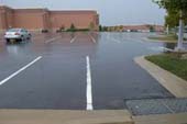
Impervious Surfaces
Impervious surfaces are surfaces, such as asphalt roads and concrete sidewalks. Impervious surfaces prevent rain from soaking into the ground, thus increasing flows during storms and reducing stream flows during dry periods. This leads to runoff that brings sediment, nutrients, and contaminants into bodies of water.
CMap

CMap Description
Coastal development is driven by population growth and the need for housing and infrastructure that depend on civil engineering & construction, as well as transportation projects. Coastal development contributes to landscape changes, including impervious surfaces that can alter patterns of water flow and lead to pollutant runoff, including sediment, toxic chemicals, nutrients, and freshwater, which can impact reef life. Many of the same socio-economic sectors, such as tourism & recreation, which drive coastal development also benefit from reef ecosystem services, including aesthetic value, seafood, and shoreline protection. Construction codes & regulations, transportation policies, and landuse management through planning, permitting, and zoning can influence intensity and distribution of impervious surfaces. Landuse restoration, such as hydroseeding along roads, can reduce runoff from impervious surfaces.Citations
| Citation | Year | Study Location | Study Type | Database Topics |
|---|---|---|---|---|
| 2011. Nonpoint Source Management Program 2010 Annual Report. Document # DEPLW-1205, Maine Department of Environmental Protection, Augusta, (Maine, USA). | 2011 | Field Study & Monitoring | Agriculture; Banks, Credit, & Securities; Chemical Use Regulations; Domestic Animal Waste; Fertilizer & Pesticide Use; Forestry; Housing; Impervious Surfaces; Microorganisms; Non-point Source Runoff; Nutrients; Physical & Chemical Water Quality Criteria; Point Source Discharges; Surface & Groundwater Flow; Wetlands | |
| Oliver, LM; Lehrter, JC; Fisher, WS. 2011. Relating landscape development intensity to coral reef condition in the watersheds of St. Croix, US Virgin Islands. Marine Ecology Progress Series 427:293-302. | 2011 | US Virgin Islands | Index or Indicator; Decision Support Frameworks & Tools | Climate; Impervious Surfaces; Landscape Changes; Sediment; Stony Coral |
| Choate, A., J. Cohen, P. Groth, D. M. Theobald, B. Bierwagen, J. Thomas, and C. Pyke. 2008. Preliminary Steps towards Integrating Climate and Land Use: The Development of Land-Use Scenarios Consistent with Climate Change Emissions Storylines. Global Change Research Program, National Center for Environmental Assessment, U.S. Environmental Protection Agency; EPA/600/R-08/076A, Washington DC. | 2008 | Global | Model; GIS & Maps | Climate; Housing; Impervious Surfaces; Landscape Changes |
| Board, M.S. 2001. Vortechnics Treatment of Parking Lot Runoff, Thesis. | 2001 | Impervious Surfaces; Non-point Source Runoff | ||
| Comings, K.J., Booth, D.B., and R.R. Horner. 2000. Storm Water Pollutant Removal by Two Wet Ponds in Bellevue, Washington, April. Journal of Environmental Engineering | 2000 | Impervious Surfaces; Non-point Source Runoff; Storms & Hurricanes; Surface & Groundwater Flow | ||
| Corsi, S.R., Breb, S.R., R.T. Bannerman and R.e. Pitt. 1999. Evaluation of the Multi-chambered Treatment Train, a Retrofit Water Quality Management Practice, USGS Open File Report 99-270, Middleton, WI. | 1999 | Field Study & Monitoring; Lab Study; GIS & Maps | Environmental Monitoring, Mapping, & Scientific Research; Impervious Surfaces; Non-point Source Runoff; Sediment; Storms & Hurricanes; Surface & Groundwater Flow | |
| Pitt, R.; Robertson, B.; and Field, R. 1998. Innovative Multi-Chambered Stormwater Control Device for Critical Source Areas. Proc. Adv. in Urban Wet Weather Pollut. Reduction , Cleveland, Ohio, WEF (CP3805), 141. | 1998 | Field Study & Monitoring; Lab Study | Discharges; Environmental Monitoring, Mapping, & Scientific Research; Impervious Surfaces; Non-point Source Runoff; Nutrients; Sediment; Surface & Groundwater Flow; Transportation Policies | |
| Pitt, R., Robertson, B. Barron, P., Ayyoubi, A. and S. Clark . 1997. Stormwater Treatment At Critical Areas Vol. 1: The Multi-Chambered Treatment Train (MCTT), USEPA Cooperative Agreement No. CR 819573 . | 1997 | Field Study & Monitoring; Lab Study | Dredging, Draining, & Filling; Environmental Monitoring, Mapping, & Scientific Research; Impervious Surfaces; Non-point Source Runoff; Sediment; Surface & Groundwater Flow | |
| Bannerman, R.; Baun, K.; Bohn, M.; Hughes, P.; Graczyk, D. 1983. Nationwide Urban Runoff Program, Milwaukee, Wisconsin. Evaluation of Urban Nonpoint Source Pollution Management in Milwaukee County, Wisconsin. Volume 2. Feasibility and Application of Urban Nonpoint Source Pollution. | 1983 | Field Study & Monitoring | Civil Engineering & Construction; Climate; Environmental Monitoring, Mapping, & Scientific Research; Impervious Surfaces; Land-Based Civil Engineering; Non-point Source Controls; Non-point Source Runoff; Point & Mobile Source Controls; Point Source Discharges; Storms & Hurricanes; Surface & Groundwater Flow; Waterborne Discharges | |
| Goforth, GF; Diniz, EV; Rauhut, JB. 1983. Stormwater hydrological characteristics of porous and conventional paving systems., NTIS, SPRINGFIELD, VA (USA), 1983., 302 pp. | 1983 | Review | Impervious Surfaces; Littering; Non-point Source Runoff; Surface & Groundwater Flow |
Management Options
| Management Option | Description | Sources | Database Topics |
|---|---|---|---|
| Damage Assessment, Documentation & Response: Respond to Natural Resource Injuries from Coastal Construction & Development | This involves assessing coral, seagrass, and hard bottom substrate that is impacted during coastal construction repair or alternation. If unacceptable damages are occurring this information will be useful in future permit decision making. If infringements have occurred, this information may be useful for compensatory mitigation and liability for restoration of those natural resources injured. | NOAA Marine Sanctuary Program. 2007. Florida Keys National Marine Sanctuary revised management plan. National Ocean Service, Key West, FL. |
Biological Monitoring & Restoration; Civil Engineering & Construction; Coastal Development; Coastal Engineering; Construction Codes & Projects; Docks & Marinas; Dredging Regulations; Dredging, Draining, & Filling; Ecosystem Monitoring & Restoration; Environmental Monitoring & Restoration; Impervious Surfaces; Infrastructural Policies; Infrastructure; Land-Based Civil Engineering; Landscape Changes; Mangroves; Mitigation; Permitting & Zoning; Physical Damage; Physical Variables; Ports & Harbors; Reef Habitat; Remediation; Resource Use Management; Seagrasses; Shoreline Armoring; Special Use Permitting; Utilities; Utility Line Construction & Maintenance; Wetland & Reef Restoration; Wetlands |
| Forestry Policy: Forestry Streamside Management Areas | There are often surface waters, such as streams and lakes, within forestry areas that require special protection. This management option involves establishing and maintaining management areas (35 to 50 feet) around these surface waters to buffer against changes in temperature, increases in sediments and nutrients, and to provide bank stability. Canopy species in these areas also provide woody debris needed for instream channel structure and aquatic species habitat. | Environmental Protection Agency Office of Water. 1993. Guidance Specifying Management Measures For Sources Of Nonpoint Pollution In Coastal Waters. EPA/840/B-92/002, US EPA, Washington, DC. Natural Resources Conservation Service. 2011. National Handbook of Conservation Practices. U.S. Department of Agriculture. |
Agriculture, Aquaculture, & Forestry Policies; Carbon Storage & Cycling; Civil Engineering & Construction; Construction Codes & Projects; Deforestation & Devegetation; Discharges; Ditching & Soil Disturbance; Food & Raw Materials; Forestry; Impervious Surfaces; Infrastructural Policies; Landscape Changes; Landscape Conservation & Restoration; Landuse Management; Non-point Source Runoff; Point & Mobile Source Controls; Primary Production; Sediment; Surface & Groundwater Flow; Waterborne Discharges; Wood, Plastics, & Chemical Products |
| Landuse Management: Temporary Road Planning and Construction | This management option involves minimizing sediment discharges from forestry and other temporary roads through their planning and construction. Since these roads are seasonal or temporary, less time and effort is normally invested in construction. Road construction has four main phases, clearing, leveling, construction and surfacing. Construction timing should be targeted to avoid sensitive spawning periods and during low stream flow at water passes. Road surface drainage shaping requires proper moisture content, surfacing, and grading. Drainage should be installed to reduce the volume and velocity of runoff water passing over sensitive areas. Methods for road surface drainage include: broad-based dip construction, pole culverts, ditch relief culverts, road outsloping and grading, ditch and turnout construction. Roadway runoff should be prevented from flowing directly into watercourses by using turnouts, wing ditches and dips. Brush barriers, silt fences, riprap and filter strips can be used to trap sediment in runoff water. Where roads cross streams it is important to guard against erosion, as such erosion may necessitate road repairs. | Environmental Protection Agency Office of Water. 1993. Guidance Specifying Management Measures For Sources Of Nonpoint Pollution In Coastal Waters. EPA/840/B-92/002, US EPA, Washington, DC. |
Agriculture, Aquaculture, & Forestry Policies; Civil Engineering & Construction; Construction Codes & Projects; Decision Support; Deforestation & Devegetation; Discharge Limitations; Discharges; Ecosystem Monitoring & Restoration; Environmental Monitoring & Restoration; Food & Raw Materials; Forestry; Hydrologic Management; Impervious Surfaces; Infrastructural Policies; Infrastructure; Land & Air Transportation; Land-Based Civil Engineering; Landscape Changes; Landscape Conservation & Restoration; Landuse Management; Mining; Mining Policies; Non-point Source Controls; Non-point Source Runoff; Nutrients; Road Construction & Maintenance; Sediment; Transportation; Transportation Policies |
| Landuse Management: Mine Reclamation | Lands disturbed by mining must be reclaimed to their Approximate Original Contour (AOC). Mine operators must backfill, compact, and grade in order to restore the AOC of the land with all highwalls, spoil piles, and depressions eliminated. Spoil material is prone to erosion, and may carry various disturbed toxics into groundwater if not properly managed. Temporary roads and impervious surfaces may have also been constructed for mining purposes. | Natural Resources Conservation Service. 2011. National Handbook of Conservation Practices. U.S. Department of Agriculture. Office of Surface Mining Reclamation and Enforcement. POSTMINING LAND USE: Exceptions to Approximate Original Contour Requirements for Mountaintop Removal Operations and steep Slope Mining Operations. Washington, DC. |
Chemical Use Regulations; Civil Engineering & Construction; Coal Mining; Construction Codes & Projects; Decision Support; Deforestation & Devegetation; Discharge Limitations; Discharges; Ditching & Soil Disturbance; Ecosystem Monitoring & Restoration; Environmental Monitoring & Restoration; Environmental Monitoring, Mapping, & Scientific Research; Food & Raw Materials; Hydrologic Management; Impervious Surfaces; Infrastructural Policies; Land-Based Civil Engineering; Landscape Changes; Landscape Conservation & Restoration; Landuse Management; Manufacturing & Trade; Manufacturing & Trade Policies; Mineral, Rock, & Metal Mining; Mining; Mining Policies; Mitigation; Non-point Source Controls; Non-point Source Runoff; Physical & Chemical Water Quality Criteria; Political Pressure; Remediation; Resource Use Management; Sediment; Surface & Groundwater Flow; Toxics; Valuation; Waterborne Discharges |
| Landuse Management: Household Landscaping Best Management Practices | Homeowners manipulate the visible features of the land surrounding their home through landscaping. This includes flora, fauna, and terrain. Best Management Practices (BMPs) for landscaping include selection of indigenous flora and fauna, landscape irrigation (sprinkler systems etc), stormwater runoff BMPs, reducing water use, integrated pest management, composting, and incorporation of permeable surfaces. | Natural Resources Conservation Service. 2011. National Handbook of Conservation Practices. U.S. Department of Agriculture. Irrigation Association. 2010. Turf and Landscape Irrigation Best Management Practices. |
Applied Chemicals; Biological Addition; Building & Home Construction; Chemical Variables; City Planning; Discharge Limitations; Environmental Education & Outreach; Escape & Release of Non-natives; Existence Value & Sense of Place; Fertilizer & Pesticide Use; Impervious Surfaces; Landscape Conservation & Restoration; Landscaping & Household Services; Landuse Management; Non-point Source Controls; Non-point Source Runoff; Nutrients; Sediment; Shelter; Supplemental Feeding; Toxics; Waterborne Discharges |
| Marine Zoning: Permitting Application & Award | This management approach is important because permits assure protection and conservation of coral resources from harmful activities and practices. Within sanctuary waters, special use permits (#157) can be used to allow scientists and others to conduct necessary work while following permitting regulations to reduce the impact of that work. General permits are often required for altering land-use, construction projects and certain discharges. To be eligible for a permit, the operator may be required to conduct impact assessments, institute best management practices and conduct monitoring of the project. Though permits are a necessary precaution, the process can be streamlined through ensuring clear submittal requirements, and reducing redundancy. Redundancy often occurs when multiple agencies must approve a permit, a single point of contact and standard, inter-agency protocols can reduce unnecessary redundancy. | NOAA Marine Sanctuary Program. 2007. Florida Keys National Marine Sanctuary revised management plan. National Ocean Service, Key West, FL. |
Biological Addition; Biological Harvest; Building & Home Construction; Coastal Development; Collaboration & Partnering; Cultural Policies; Discharges; Dredging, Draining, & Filling; Impervious Surfaces; Land-Based Civil Engineering; Landscape Changes; Landuse Management; Permitting & Zoning; Physical Damage; Point Source Discharges; Public Administration; Resource Use Management; Scientific Research; Security & Public Administration Policies; Special Use Permitting |
| Monitor & Research: Research Historical Hydrology | This activity involves a historical assessment of the hydrology of the surrounding water area around the sanctuary as it has affected water quality and biological communities within the sanctuary. It will clarify the role of freshwater inflows and water quality from local freshwater bodies. Also, this activity will examine the effects of structural modification and changes in quality, quantity, timing and distribution of freshwater releases from existing structures and will examine land-based practices affecting the water quality of runoff. | NOAA Marine Sanctuary Program. 2007. Florida Keys National Marine Sanctuary revised management plan. National Ocean Service, Key West, FL. |
Applied Chemicals; Chemical Variables; Coastal Development; Coastal Engineering; Dam Construction & Maintenance; Deforestation & Devegetation; Discharge Limitations; Discharges; Ditching & Soil Disturbance; Dredging, Draining, & Filling; Ecosystem Monitoring & Restoration; Environmental Monitoring & Restoration; Environmental Monitoring, Mapping, & Scientific Research; Hydrologic Management; Impervious Surfaces; Infrastructural Policies; Landscape Changes; Landuse Management; Physical Variables; Salinity; Seawater Flow; Shoreline Armoring; Stormwater Management; Surface & Groundwater Flow; Water; Water Depth & Sea Level; Water Transportation; Waterborne Discharges |
| Stormwater BMPs: Structural Stormwater Retention/Detention | This method attempts to reduce the negative impacts of stormwater runoff through implementation of engineering structures that retain runoff water for further treatment or controlled release. Water collection can be selective, targeting the first flush of water, which is typically the most polluted. Water retention has the additional benefit of later release at a place and time when the water is needed (e.g. for irrigation). Rainwater Collection Systems (#11) can be an important water resource in areas where freshwater is limited. | Natural Resources Conservation Service. 2011. National Handbook of Conservation Practices. U.S. Department of Agriculture. Natural Resources Conservation Service. Combined Infiltration/Detention Basin. Urban BMP's - Water Runoff Management Accessed 3/23/2011. Natural Resources Conservation Service. Detention Devices for Dry/Wet Ponds. Urban BMP's - Water Runoff Management Accessed 3/23/2011. Natural Resources Conservation Service. Dry Extended Detention Ponds. Urban BMP's - Water Runoff Management Accessed 3/23/2011. Leisenring, M., Clary, J., Stephenson, J., and Hobson, P. 2010. International Stormwater Best Management Practices (BMP) Database Pollutant Category Summary: Nutrients. Geosyntec Consultants, Inc. Poresky, A., Clary, J., Strecker, E., and Earles, A. 2011. International Stormwater Best Management Practices (BMP) Database. Technical Summary: Volume Reduction. Geosyntec Consultants. Natural Resources Conservation Service. 2010. Stormwater Runoff Controls. U.S. Depatrment of Agriculture. Natural Resources Conservation Service. 2008. Water and Sediment Control Basin. CODE 638. U.S. Depatrment of Agriculture. Natural Resources Conservation Service. Water Volume Management. Urban BMP's - Water Runoff Management Accessed 3/25/2011. |
Agriculture, Aquaculture, & Forestry Policies; Applied Chemicals; Chemical Variables; City Planning; Civil Engineering & Construction; Climate; Coastal Development; Construction Codes & Projects; Deforestation & Devegetation; Discharge Limitations; Discharges; Ditching & Soil Disturbance; Hydrologic Management; Impervious Surfaces; Infrastructural Policies; Infrastructure; Land-Based Civil Engineering; Landscape Changes; Landuse Management; Non-point Source Controls; Non-point Source Runoff; Physical Variables; Point Source Discharges; Sediment; Shoreline Armoring; Storms & Hurricanes; Stormwater Management; Substrate; Surface & Groundwater Flow; Utilities; Utility Policies; Waste Management; Waste Management Policies; Wastewater Discharge; Water; Waterborne Discharges |
| Stormwater BMPs: Structural Stormwater Infiltration | This management option attempts to reduce the negative impacts of stormwater runoff through implementation of engineering structures that control the volume of surface water, facilitating faster absorption of the stormwater into the ground. Often these structures are able to infiltrate larger amounts of water faster while reducing exposure to surface sediments and pollutants. | Natural Resources Conservation Service. Combined Infiltration/Detention Basin. Urban BMP's - Water Runoff Management Accessed 3/23/2011. Leisenring, M., Clary, J., Stephenson, J., and Hobson, P. 2010. International Stormwater Best Management Practices (BMP) Database Pollutant Category Summary: Nutrients. Geosyntec Consultants, Inc. Poresky, A., Clary, J., Strecker, E., and Earles, A. 2011. International Stormwater Best Management Practices (BMP) Database. Technical Summary: Volume Reduction. Geosyntec Consultants. US EPA. EPA Infiltration BMPs. National Pollutant Discharge Elimination System Menu of BMPs Accessed 3/25/2011. |
Applied Chemicals; Chemical Variables; City Planning; Civil Engineering & Construction; Climate; Coastal Development; Construction Codes & Projects; Deforestation & Devegetation; Discharge Limitations; Discharges; Ditching & Soil Disturbance; Drinking Water Supply; Fertilizer & Pesticide Use; Hydrologic Management; Impervious Surfaces; Infrastructural Policies; Irrigation; Land-Based Civil Engineering; Landscape Changes; Landuse Management; Non-point Source Controls; Non-point Source Runoff; Point Source Discharges; Sediment; Storms & Hurricanes; Stormwater Management; Substrate; Supporting Services; Surface & Groundwater Flow; Waste Management Policies; Wastewater Discharge; Water; Waterborne Discharges |
| Stormwater BMPs: Structural Stormwater Filtration | This method attempts to reduce the negative impacts of stormwater runoff through implementation of engineering structures that trap or filter impurities out of runoff water. These include but are not limited to, using swales, filter strips, oil/water separators, oil/grit separators, and sand filters. Often structural retrofitting is coupled with biological filters/controls to direct water as desired and to fully reap the benefits of both systems. Structural filters are often incorporated into retention/detention and infiltration systems as well. One disadvantage of structural filters is that they are often higher maintenance as sand and chambers fill and clog with pollutants over time. | NOAA Marine Sanctuary Program. 2007. Florida Keys National Marine Sanctuary revised management plan. National Ocean Service, Key West, FL. Natural Resources Conservation Service. Compost Filter System. Urban BMP's - Water Runoff Management Accessed 3/23/2011. Natural Resources Conservation Service. Dry Swale. Urban BMP's - Water Runoff Management Accessed 3/23/2011. Natural Resources Conservation Service. Median Strip Infiltration Trench. Urban BMP's - Water Runoff Management Accessed 3/23/2011. Natural Resources Conservation Service. Montgomery County Water Quality Inlet. Urban BMP's - Water Runoff Management Accessed 3/23/2011. Natural Resources Conservation Service. Off-Line Infiltration Basin. Urban BMP's - Water Runoff Management Accessed 3/23/2011. Natural Resources Conservation Service. Oil/Water Separators. Urban BMP's - Water Runoff Management Accessed 3/23/2011. Natural Resources Conservation Service. Organic Sand Filter. Urban BMP's - Water Runoff Management Accessed 3/23/2011. Natural Resources Conservation Service. Peat Sand Filter. Urban BMP's - Water Runoff Management Accessed 3/23/2011. Natural Resources Conservation Service. Perimeter Sand Filter. Urban BMP's - Water Runoff Management Accessed 3/23/2011. Natural Resources Conservation Service. Pocket Sand Filter. Urban BMP's - Water Runoff Management Accessed 3/23/2011. Natural Resources Conservation Service. Rockville Water Quality Inlet. Urban BMP's - Water Runoff Management Accessed 3/23/2011. Natural Resources Conservation Service. Sediment Basin (Water Quality Enhancement). Urban BMP's - Water Runoff Management Accessed 3/23/2011. Natural Resources Conservation Service. Side-by-Side Infiltration Basin. Urban BMP's - Water Runoff Management Accessed 3/23/2011. Natural Resources Conservation Service. Surface Sand Filter. Urban BMP's - Water Runoff Management Accessed 3/23/2011. Natural Resources Conservation Service. Underground Sand Filter. Urban BMP's - Water Runoff Management Accessed 3/23/2011. Natural Resources Conservation Service. Underground Trench with Oil/Grit Chamber. Urban BMP's - Water Runoff Management Accessed 3/23/2011. Natural Resources Conservation Service. Under-the-Swale Infiltration Trench. Urban BMP's - Water Runoff Management Accessed 3/23/2011. Natural Resources Conservation Service. Water Quality Volume (WQV) Storage Tank. Urban BMP's - Water Runoff Management Accessed 3/23/2011. Water Environment Research Foundation, American Society of Civil Engineers, U.S. Environmental Protection Agency, Federal Highway Administration, American Public Works Association, editor. 2008. Overview of Performance by BMP Category and Common Pollutant Type. International Stormwater Best Management Practices (BMP) Database [1999-2008]. Leisenring, M., Clary, J., Stephenson, J., and Hobson, P. 2010. International Stormwater Best Management Practices (BMP) Database Pollutant Category Summary: Nutrients. Geosyntec Consultants, Inc. US EPA. EPA Filtration BMPs. National Pollutant Discharge Elimination System Menu of BMPs Accessed 3/25/2011. US EPA. Manufactured Products for Stormwater Inlets. National Pollutant Discharge Elimination System Menu of BMPs Accessed 3/25/2011. US EPA. Alum Injection. National Pollutant Discharge Elimination System Menu of BMPs Accessed 3/25/2011. Natural Resources Conservation Service. 2010. Stormwater Runoff Controls. U.S. Depatrment of Agriculture. Natural Resources Conservation Service. 2005. Solid/liquid Waste Separation Facility. U.S. Depatrment of Agriculture. |
Applied Chemicals; Chemical Variables; City Planning; Civil Engineering & Construction; Coastal Engineering; Construction Codes & Projects; Dam Construction & Maintenance; Discharge Limitations; Discharges; Ditching & Soil Disturbance; Food & Energy Policies; Hydrologic Management; Impervious Surfaces; Improved Technology; Infrastructural Policies; Infrastructure; Land-Based Civil Engineering; Landscape Changes; Landscape Conservation & Restoration; Landuse Management; Non-point Source Controls; Non-point Source Runoff; Physical Variables; Point & Mobile Source Controls; Point Source Discharges; Road Construction & Maintenance; Sediment; Storms & Hurricanes; Stormwater Management; Surface & Groundwater Flow; Toxics; Utilities; Utility Policies; Waste Management; Waste Management Policies; Wastewater Discharge; Waterborne Discharges |
| Stormwater BMPs: Rainwater Collection Systems | Creating a rainwater collection system (either through policy change or the initiative of homeowners) would help in many ways. These systems would utilize water in an efficient manner. It would reduce the pressure of water as a finite resource. Water would be collected and utilized before it reaches the ground. Once rain falls to the ground, it picks up nutrients, chemicals, and pathogens on the ground and transports them in the form of runoff. Eventually this contaminated stormwater runoff enters water resources through the drainage basin. Collecting a considerable amount of water would prevent contamination of that water, and allow for it to be usable. Also, it would reduce the amount of water that is lost when it is contaminated as runoff. An overall reduced amount of stormwater runoff would reduce the amount of contaminants that would harm corals. | Center for Watershed Protection. 2008. Guanica Bay watershed management plan. Natural Resources Conservation Service. Cisterns used for water harvesting. Urban BMP's - Water Runoff Management Accessed 3/18/2011. Leisenring, M., Clary, J., Stephenson, J., and Hobson, P. 2010. International Stormwater Best Management Practices (BMP) Database Pollutant Category Summary: Nutrients. Geosyntec Consultants, Inc. |
Applied Chemicals; Building & Home Construction; Chemical Variables; City Planning; Civil Engineering & Construction; Cleaner & Solvent Use; Climate; Construction Codes & Projects; Deforestation & Devegetation; Discharge Limitations; Discharges; Ditching & Soil Disturbance; Drinking Water Supply; Fertilizer & Pesticide Use; Food & Energy Policies; Impervious Surfaces; Infrastructural Policies; Infrastructure; Irrigation; Land-Based Civil Engineering; Landscape Changes; Landscaping & Household Services; Landuse Management; Non-point Source Controls; Non-point Source Runoff; Physical Variables; Point & Mobile Source Controls; Point Source Discharges; Sediment; Shelter; Storms & Hurricanes; Stormwater Management; Substrate; Surface & Groundwater Flow; Toxics; Utilities; Utility Policies; Waste Management; Waste Management Policies; Wastewater Discharge; Water; Water Utilities Policies; Waterborne Discharges |
| Stormwater BMPs: Biological Stormwater Filtration | This method attempts to reduce the negative impacts of stormwater runoff through implementing engineering techniques that allow natural processes and plants to act as filters. Such techniques would include using grass parking and turf covered swales. Many of these techniques, such as reversed elevations for planted areas in parking lots, can demonstrate benefits both as natural filters and for the vegetation that are used since it eliminates the need to water them with irrigation systems. | NOAA Marine Sanctuary Program. 2007. Florida Keys National Marine Sanctuary revised management plan. National Ocean Service, Key West, FL. Natural Resources Conservation Service. 2011. National Handbook of Conservation Practices. U.S. Department of Agriculture. Natural Resources Conservation Service. Basic Biofiltration Swale. Urban BMP's - Water Runoff Management Accessed 3/23/2011. Natural Resources Conservation Service. Bioretention System. Urban BMP's - Water Runoff Management Accessed 3/23/2011. Natural Resources Conservation Service. Constructed Wetland. Urban BMP's - Water Runoff Management Accessed 3/23/2011. Natural Resources Conservation Service. Filter Strips. Urban BMP's - Water Runoff Management Accessed 3/23/2011. Natural Resources Conservation Service. Reversed Elevations System for Parking Lots and Planting Areas. Urban BMP's - Water Runoff Management Accessed 3/23/2011. Natural Resources Conservation Service. Riparian Forest Buffer. Urban BMP's - Water Runoff Management Accessed 3/23/2011. Natural Resources Conservation Service. Roadway Landscape Treatment System. Urban BMP's - Water Runoff Management Accessed 3/23/2011. Natural Resources Conservation Service. Wet Biofiltration Swale. Urban BMP's - Water Runoff Management Accessed 3/23/2011. Natural Resources Conservation Service. Wet Pond Design. Urban BMP's - Water Runoff Management Accessed 3/23/2011. Natural Resources Conservation Service. Wet Swale. Urban BMP's - Water Runoff Management Accessed 3/23/2011. Water Environment Research Foundation, American Society of Civil Engineers, U.S. Environmental Protection Agency, Federal Highway Administration, American Public Works Association, editor. 2008. Overview of Performance by BMP Category and Common Pollutant Type. International Stormwater Best Management Practices (BMP) Database [1999-2008]. Leisenring, M., Clary, J., Stephenson, J., and Hobson, P. 2010. International Stormwater Best Management Practices (BMP) Database Pollutant Category Summary: Nutrients. Geosyntec Consultants, Inc. |
Applied Chemicals; Building & Home Construction; Chemical Variables; City Planning; Civil Engineering & Construction; Climate; Construction Codes & Projects; Deforestation & Devegetation; Discharge Limitations; Discharges; Ditching & Soil Disturbance; Fertilizer & Pesticide Use; Golf Course Operations; Impervious Surfaces; Infrastructure; Irrigation; Land-Based Civil Engineering; Landscape Changes; Landscape Conservation & Restoration; Landscaping & Household Services; Landuse Management; Non-point Source Controls; Non-point Source Runoff; Nutrient & Contaminant Processing; Physical Variables; Point & Mobile Source Controls; Point Source Discharges; Primary Production; Road Construction & Maintenance; Sediment; Storms & Hurricanes; Stormwater Management; Substrate; Supporting Services; Surface & Groundwater Flow; Toxics; Utilities; Waste Management; Waste Management Policies; Wastewater Discharge; Water; Waterborne Discharges |
| Transportation Policy: Dust Control Application | This action is taken to control dust from unpaved roads and other surfaces, which is generated by traffic and/or wind. Some dust control products (palliatives) for application include: water, hydroscopic palliatives, adhesive, petroleum emulsion, polymer emulsion, clay additive, and bituminous. There are specific considerations for application of each, including seasons and when to use which. For example, hygroscopic palliatives (control dust by absorbing water from the air) shall not be used in arid and semi-arid environments. Calcium chloride and magnesium chloride shall not be used in locations where the daily summertime relative humidity averages below 30%. | Natural Resources Conservation Service. 2011. National Handbook of Conservation Practices. U.S. Department of Agriculture. |
Agriculture; Construction Codes & Projects; Discharge Limitations; Discharges; Food & Raw Materials; Forestry; Impervious Surfaces; Infrastructural Policies; Land & Air Transportation; Mining; Non-point Source Controls; Non-point Source Runoff; Sediment; Transportation; Transportation Policies |
| Waterway Management: Remove Previous Canal and Irrigation Infrastructure | Canal and irrigation infrastructure typically includes concrete structures to control the flow of water. These low head dams, bulkheads, concrete footers, and other structures act as constricting forces in channels. This constriction leads to debris becoming lodged and thus changing the erosive forces. In turn, banks become destabilized. Channel erosion then increases along with bed scour and sediment transport. Removing these structures and making banks more gradual has the added benefit of allowing for riparian vegetation to be planted, which acts as a natural buffer. | Center for Watershed Protection. 2008. Guanica Bay watershed management plan. |
Agriculture; Agriculture, Aquaculture, & Forestry Policies; Boat Movement; Boating Activities; City Planning; Civil Engineering & Construction; Coastal Engineering; Construction Codes & Projects; Dam Construction & Maintenance; Deforestation & Devegetation; Discharge Limitations; Discharges; Ditching & Soil Disturbance; Ecosystem Monitoring & Restoration; Environmental Monitoring & Restoration; Food & Raw Materials; Hydrologic Management; Impervious Surfaces; Infrastructural Policies; Irrigation; Land-Based Civil Engineering; Landscape Changes; Landscape Conservation & Restoration; Landuse Management; Non-point Source Controls; Physical Damage; Sediment; Shoreline Protection; Small Boats; Substrate; Surface & Groundwater Flow; Transportation; Water; Water Resources; Water Transportation; Waterborne Discharges |
Laws
| Legal Citation | Purpose of Law | Management Organization | Database Topics |
|---|---|---|---|
| Regulation of stormwater discharge, 62-25 Florida Administrative Code Annotated (1988). | The discharge of untreated stormwater may reasonably be expected to be a source of pollution of waters of the state and is, therefore, subject to Department regulation. The Departmnet shall prevent pollution of waters of the state by discharges of stormwater, to ensure that the designated most beneficial uses of waters, as prescribed by Chapter 62-302, F.A.C., are protected. A permit under this chapter will be required only for new stormwater discharge facilities as defined herein. This provision shall not affect the Department's authority to require appropriate corrective action, pursuant to Sections 403.121-.161.F.S., whenever existing facilities cause or contribute to violations of state water quality standards. Stormwater discharges to groundwaters shall be regulated under the provisions of Chapters 62-520 and 62-522, F.A.C., and other applicable rules of the Department. The Department intends that, to the greatest extent practicable, the provisions of this chapter be delegated to either local governments or water management districts seeking such delegation. Application to Coral Reefs:Limiting the contaminants and their concentrations in stormwater discharge will reduce the contamination reaching various habitats, including coral reefs. Legislative Actions: Comments: |
Floridfa Department of Environmental Protection Jurisdiction: US State Waters |
Agriculture, Aquaculture, & Forestry Policies; Building & Home Construction; Construction Codes & Projects; Dredging, Draining, & Filling; Impervious Surfaces; Landuse Management; Nutrient & Contaminant Processing; Nutrients; Sediment; Waste Management Policies; Wastewater Discharge |
| Surface water quality standards, 62-302 Florida Administrative Code Annotated (2008). | The Chapter establishes the minimum concentrations of contamination that are allowable to protect the designated uses of a waterbody. Designated uses include public drinking water supplies, propagation of fish and wildlife, agricultural, recreation, industrial, and navigation. Application to Coral Reefs:Protecting surface waters by limiting the concentration of pollutants that can be present will control the concentrations of those pollutants that will reach estuarine and marine environments, thus protecting the associated ecosystems, including coral reefs. Legislative Actions:Penalties are not presented in the Rule. Specific requirements and penalties are addrressed in individual permits. The Rule relies heavily on biocriteria including acute toxicity, chronic toxicity, Shannon-Weaver Diversity Index. Section 400 presents the classes of Florida waters; Class I potable water supplies, Class II shellfish propagation or harvesting, Class III recreation, propagation and maintenance of a healthy, well-balanced population of fish and wildlife, Class IV agricultural water supplies, Class V navigation, utility and industrial use. Comments: |
Florida Department of Environmental Protection Jurisdiction: State Coastal Waters; US State Waters; Designated Marine Areas |
Biocriteria; Biological Monitoring, Mapping, & Scientific Research; Civil Engineering & Construction; Coastal Development; Commercial Fisheries; Complex Habitat & Resources; Dam Construction & Maintenance; Deforestation & Devegetation; Designate Protected Species; Discharge Limitations; Dive, Snorkeling, & Swimming Tourism; Docks & Marinas; Dredging Regulations; Dredging, Draining, & Filling; Drinking Water Supply; Fertilizer & Pesticide Use; Finfish & Shellfish Stock; Fish; Fishing & Harvesting Management; Impervious Surfaces; Invertebrates; Irrigation; Landuse Management; Molluscs; Non-point Source Controls; Non-point Source Runoff; Nutrient & Contaminant Processing; Nutrients; Physical & Chemical Water Quality Criteria; Pipelines; Point & Mobile Source Controls; Point Source Discharges; Ports & Harbors; Recreational Fishing; Sediment; Sewage Treatment; Shoreline Armoring; Small Boats; Tourism & Recreation Policies; Toxics; Waste Management Policies |
| Total maximum daily loads, 62-304 Florida Administrative Code Annotated (2006). | The Chapter establishes Total Maximum Daily Loads (TMDLs), and their allocations, for waters that have been verified to be impaired by a pollutant pursuant to Chapter 62-303. F.A.C. Application to Coral Reefs:By regulating the amount of pollutants that will be allowed to be discharged into major waterbodies of the state, the amount of pollutants reaching estuarine and then marine environments, and eventually coral reefs, will assist in protecting the reefs and other habitats. Legislative Actions:The planning list of impaired water bodies has been completed. Data on each water bodies has been collected. DEP is in the process of calculating TMDLs for each water body. Comments: |
Florida Department of Envitonmental Protection Jurisdiction: United States; State Coastal Waters |
Agriculture, Aquaculture, & Forestry Policies; Aquaculture; Ballast Discharge; Biomedical Research Policies; Coastal Development; Deforestation & Devegetation; Ditching & Soil Disturbance; Dredging Regulations; Finfish & Shellfish Stock; Impervious Surfaces; Irrigation; Landuse Management; Metals, Electronics, & Machinery Products; Nutrient & Contaminant Processing; Nutrients; Physical & Chemical Water Quality Criteria; Point Source Discharges; Resource Use Management; Sediment; Sewage Treatment; Shoreline Armoring; Solid Waste Disposal; Waste Management Policies; Wastewater Discharge; Wetland & Reef Restoration; Wood, Plastics, & Chemical Products |