Use C-FERST with EPA's Community Action for a Renewed Environment Roadmap
What is the CARE Roadmap?
The EPA CARE Roadmap provides a structured process to
- Learn about local environmental and environmental health risks and impacts
- Build the community consensus necessary to take effective action
- Mobilize a community partnership to take action to reduce impacts and risks
- Build long-term capacity within your community to understand and reduce environmental impacts and risks
The EPA CARE Resource Guide, a key resource developed by EPA's former CARE program, helps users find online resources that can help communities through every step of the process as they move from getting organized to becoming stewards of their own environment.
Use C-FERST with the EPA's CARE Roadmap
C-FERST has tools and information that can help you with some steps of the CARE Roadmap. EPA’s former CARE Program was a key partner in the development of C-FERST.
CARE Roadmap Steps
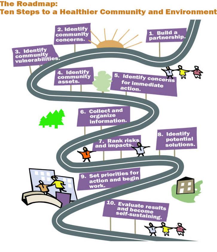
10 Steps of the CARE Roadmap
Step 1: Build a Partnership
"Build a collaborative partnership representing a broad range of interest that is able to identify environmental risks and impacts, build consensus and mobilize all the resources necessary to achieve community goals."
C-FERST Resources for this step:
- Partners Table
Use the Partners Table to enter and save information on the people and organizations involved in your partnership.
Step 2: Identify Community Concerns
"Identify the environmental, health, and related social and economic concerns of the community."
C-FERST Resources for this step:
- Maps
C-FERST Maps contain environmental and social conditions that your community may be concerned about, such as sources and concentrations of pollution in the environment. - Community Data Table
The Community Data Table has environmental and demographic information that you can compare at the county and state level.
Step 3: Identify Community Vulnerabilities
"Identify community vulnerabilities that may increase risks from environmental stressors."
C-FERST Resources for this step:
- Maps
C-FERST Maps contain environmental and social conditions that your community may be concerned about, such as sources and concentrations of pollution in the environment. - Community Data Table
The Community Data Table has environmental and demographic information that you can compare at the county and state level.
Step 4: Identify Community Assets
"Develop a list of community assets in order to build on the existing strengths of the community."
C-FERST Resources for this step:
- Partners Table
Use the Partners table to enter and save information on the people and organizations involved in your partnership.
Other Resources for this step:
- EPA EnviroAtlas
EnviroAtlas provides information about access to “green space” and other ecosystem services which may be community assets in reducing pollutant levels and their effects.
Step 5: Identify Concerns for Immediate Action
"Identify and begin to address immediate concerns and vulnerabilities."
C-FERST Resources for this step:
- Exposure and Risk Reduction Options
C-FERST has links to exposure and risk reduction options for several issues that you can explore if your community has immediate concerns about one of these issues.
*C-FERST is a screening-level tool. We do not recommend taking action solely on the basis of the information in C-FERST.
Step 6: Collect and Organize Information
"Collect and summarize available information on stressors, concerns and vulnerabilities, and identify gaps where the information on stressors, concerns and vulnerabilities is missing or inadequate."
C-FERST Resources for this step:
- Maps
C-FERST Maps contain environmental and social conditions that your community may be concerned about, such as sources and concentrations of pollution in the environment. - Community Data Table
The Community Data Table has environmental and demographic information that you can compare at the county and state level. - Environmental Issue Profiles
Gather information on stressors and concerns for your community. - Environmental Measurement Methods
Explore methods for collecting information on environmental conditions such as air quality and indoor pollutants.
Step 7: Rank Risks and Impacts
"Compare and rank community concerns to help identify those with the greatest impact."
C-FERST Resources for this step:
- Community Data Table
The Community Data Table has environmental and demographic information that you can compare at the county, state and national level.
Step 8: Identify Potential Solutions
"Identify and analyze options for reducing priority concerns and vulnerabilities and filling information gaps."
C-FERST Resources for this step:
- Exposure and Risk Reduction Options and Community Projects
Explore links on exposure and risk reduction options. View information on how other communities have addressed environmental issues. - Environmental Measurement Methods
See methods for collecting information on environmental conditions such as air quality and indoor pollutants.
Step 9: Set Priorities for Action and Begin Work
"Decide on an action plan to address concerns, fill information gaps, and mobilize the community and its partners to carry out the plan."
Resources for this step:
- PACE-EH Workbook
The Priority Setting Worksheet on page 57 of the PACE-EH Guidebook may be a useful resource for setting priorities for an action plan to address concerns.
Step 10: Evaluate Results & Become Self-Sustaining
"Evaluate the results of community action, analyze new information and develop a plan to restart the Roadmap process. You can restart the process as needed to reestablish priorities, develop new plans for action, collect information and make your partnership self-sustaining."
C-FERST Resources for this step:
- Maps
C-FERST Maps contain environmental and social conditions that your community may be concerned about, such as sources and concentrations of pollution in the environment. Data on community environmental health concerns can be revisited over time to evaluate progress. - Community Data Table
The Community Data Table has environmental and demographic information that you can compare at the county and state level.