Geographic Information Systems (GIS)
National Information
- EPA Environmental Dataset Gateway
- BASINS Water Quality Tools & Models
- EnviroMapper
- Envirofacts Data Warehouse
- Environmental Justice Geographic Assessment Tool
- Geospatial Data Download Service
- Surf Your Watershed
- Multi-Resolution Landscape Characteristics Consortium
- National Geospatial Program
- Federal Emergency Mgmt. Agency - Mapper
- Federal Geographic Data Committee
- Data.Gov
- National Atlas
- National Geophysical Data Center
- US Army Corps of Engineers - Maps and Charts
- US Census Bureau Data Tools and Apps
- US Dept. of Agriculture - Geospatial Data
- US Fish & Wildlife Service - National Wetlands Inventory
- US Geological Survey - National Geospatial Program
- US Geological Survey - The National Map
- Water Data Downloads
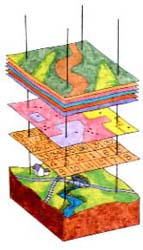
GIS Layers
Credit: Bureau of Land Management
Mid-Atlantic Information 
- Delaware Geospatial Data Exchange
- District of Columbia Geographic Information System Program
- Maryland State Geographic Information Committee
- Pennsylvania Dept. of Env'l Protection - GIS & Mapping Tools
- Pennsylvania Spatial Data Access
- University of Virginia Library - Scholars’ Lab Geospatial Data Portal
- Virginia Department of Forestry - GIS
- Virginia GIS Data Layers
- West Virginia GIS Technical Center
- West Virginia - Map West Virginia
On this page
What is GIS?
A Geographic Information System or GIS is a computer system that allows you to map, model, query, and analyze large quantities of data within a single database according to their location. GIS gives you the power to:
- create maps
- integrate information
- visualize scenarios
- present powerful ideas, and
- develop effective solutions
GIS is a tool used by individuals and organizations, schools, governments, and businesses seeking innovative ways to solve their problems. GIS stores information about the world as a collection of layers that can be linked together by a common locational component such as latitude and longitude, a postal zip code, census tract name, or road name. These geographic references allow you to locate features on the earth's surface for analysis of patterns and trends. Dozens of map layers can be arrayed to display information about transportation networks, hydrography, population characteristics, economic activity, and political jurisdictions.
How Do We Use It?
Geographic or spatial information can assist in understanding the complex interrelationships of natural resources and human population as they relate to potential or known pollution sources. This additional information is beneficial to us in accomplishing our mission of protecting human health and the environment. The EPA Mid-Atlantic Region has a GIS Team which provides the necessary spatial data to our Regional staff to assist in environmental decision-making. This involves:
- acquiring and maintaining accurate locational data of regulated facilities, pollutant sources and environmental resources,
- providing appropriate access to data
- developing customized GIS maps, tools and applications, and
- providing technical assistance to support GIS needs
Contact
Don Evans (evans.don@epa.gov)
Geographic Information Systems (GIS) Team Leader
Office of Environmental Information & Analysis (3EA10)
Environmental Assessment & Innovation Division
US EPA Region 3
1650 Arch St.
Philadelphia, PA 19103-2029
215-814-5370