 Northern
California Metric Maps Northern
California Metric Maps
HUCs
- 10 digit
U_INDEX
Human Land Use
RHUM0
Stream Corridor
RHUM30
30 Meter
RHUM90
90 Meter
N_INDEX
Natural Land Use
RNAT0
Stream Corridor
RNAT30
30 Meter
RNAT90
90 Meter
PBAR
Barren
RBAR0
Stream Corridor
RBAR30
30 Meter
RBAR90
90 Meter
PAGT
Agriculture
 RAGT0
Stream Corridor RAGT0
Stream Corridor 
RAGT30
30 Meter
RAGT90
90 Meter
PAGC
Cropland
RAGC0
Stream Corridor
RAGC30
30 Meter
RAGC90
90 Meter
PAGP
Pasture
RAGP0
Stream Corridor
RAGP30
30 Meter
RAGP90
90 Meter
PURB
Urban
RURB0
Stream Corridor
RURB30
30 Meter
RURB90
90 Meter
PWETL
Wetland
RWETL0
Stream Corridor
RWETL30
30 Meter
RWETL90 90 Meters
PFOR
Forest
RFOR0
Stream Corridor
RFOR30
30 Meter
RFOR90
90 Meter
AGTSL5
- Steep Slopes
STRMLEN
Stream Length
STRMDENS
Stream Density
RDLEN
Road Length
RDLENCINTE
Interstates
RDLENCHIGH
Highways
RDLENCROAD
Surface Road
RDDENS
Road Density
RDDENSCINT
Interstates
RDDENSCHIG
Highways
RDDENSCROA
Surface Road
FNUMBER
Forest Patches
FPATDENS
Forest Density
FLARGEST
Largest Forest
FAVGSIZE
Average Forest
PLGP
Proportion of Forest
FEDGE210
Forest Edge
FCORE210
Forest Interior
FEA210
Forest Edge/Total
PFF9
Forest Cell
PFPTCH9
Watershed/Patch Forest
PFTRAN9
Watershed/Transitional
PFEDGE9
Watershed/Edge Forest
PFPERF9
Watershed/Perforated
PFINTR9
Watershed/Interior
REGFAC_COUNT
Regulated Facilities
MINES_COUNT
Mines
POPDENS
Population Density
|
 Larger
Image Larger
Image
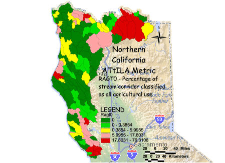
RAGT0 - Percentage of stream corridor classified as all agricultural use
The percentage of all agricultural land cover adjacent to streams is calculated
by summing the total number of pasture, crop and orchard land cover cells
underneath stream segments in the watershed and dividing by the stream
corridor's total land area (total number cells underneath stream segments
minus those classified as water). Agricultural practices typically employ
fertilizers, pesticides and other chemicals that may be transported to streams
in water runoff. The closer agriculture is to a stream the more likely related
pollutants will enter the stream. Concentrations of pollutants transported into
streams are also more likely to be higher when agriculture is closer to streams.
Animals grazing in pasture land may decrease vegetation cover possibly
leading to increased runoff. Livestock may also impair stream banks by
trampling riparian vegetation, which may cause increased sedimentation in the
stream.
|