|
|
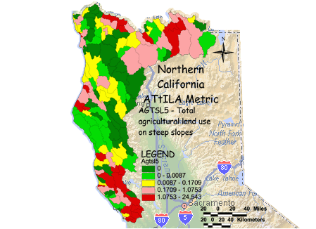
AGTSL5 - Total agricultural land use on steep slopes The proportion of each watershed that has agriculture land cover on slopes greater then 5 percent was calculated by overlaying maps of percent slope and agricultural land cover, which included crops, pasture and orchards. The area of agriculture on steep slopes was then divided by the total land area of the watershed. The total agricultural land use on steep slopes can be a measure of increased soil erosion which could also cause sediment in streams and lakes. The potential soil erosion from agricultural lands is related to the steepness of slopes being cultivated, soil type and the farming methods used. Agriculture on slopes greater than 5% ranged from 0% to a little under 5% of total area in the watersheds. The proportions are lower in remote mountainous areas since less agriculture can be found there, agriculture in this area tends to be located in the flatter river valleys. The values seen here in the Northern California Mountain area are generally lower when compared to the central and eastern United States. |
Environmental Sciences: Northern California
- You are here: EPA Home
- Environmental Sciences
- Northern California
- ATtILA (Metric Maps)
- Agricultural Land Use on Steep Slopes