 Northern
California Metric Maps Northern
California Metric Maps
HUCs
- 10 digit
U_INDEX
Human Land Use
RHUM0
Stream Corridor
RHUM30
30 Meter
RHUM90
90 Meter
N_INDEX
Natural Land Use
RNAT0
Stream Corridor
RNAT30
30 Meter
RNAT90
90 Meter
PBAR
Barren
RBAR0
Stream Corridor
RBAR30
30 Meter
RBAR90
90 Meter
PAGT
Agriculture
RAGT0
Stream Corridor
RAGT30
30 Meter
RAGT90
90 Meter
PAGC
Cropland
RAGC0
Stream Corridor
RAGC30
30 Meter
RAGC90
90 Meter
PAGP
Pasture
RAGP0
Stream Corridor
RAGP30
30 Meter
RAGP90
90 Meter
PURB
Urban
RURB0
Stream Corridor
RURB30
30 Meter
RURB90
90 Meter
PWETL
Wetland
RWETL0
Stream Corridor
RWETL30
30 Meter
RWETL90
90 Meter
PFOR
Forest
RFOR0
Stream Corridor
RFOR30
30 Meter
RFOR90
90 Meter
AGTSL5
- Steep Slopes
STRMLEN
Stream Length
STRMDENS
Stream Density
RDLEN
Road Length
RDLENCINTE
Interstates
RDLENCHIGH
Highways
RDLENCROAD
Surface Road
RDDENS
Road Density
RDDENSCINT
Interstates
RDDENSCHIG
Highways
RDDENSCROA
Surface Road
FNUMBER
Forest Patches
FPATDENS
Forest Density
FLARGEST
Largest Forest
FAVGSIZE
Average Forest
PLGP
Proportion of Forest
FEDGE210
Forest Edge
FCORE210
Forest Interior
FEA210
Forest Edge/Total
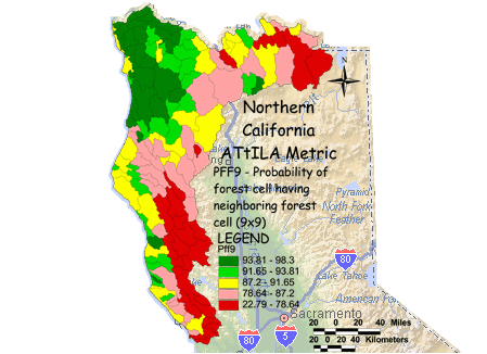
 PFF9
Forest Cell PFF9
Forest Cell 
PFPTCH9
Watershed/Patch Forest
PFTRAN9
Watershed/Transitional
PFEDGE9
Watershed/Edge Forest
PFPERF9
Watershed/Perforated
PFINTR9
Watershed/Interior
REGFAC_COUNT
Regulated Facilities
MINES_COUNT
Mines
POPDENS
Population Density
|
 Larger
Image Larger
Image
PFF9 - Probability of forest cell having neighboring forest cell (9x9)
Probability of a forest cell having a neighboring forest cell is calculated using a
moving 270 meter square window (9 pixels x 9 pixels) across the land cover.
The boundaries between all pixel pairs where at least one pixel was forest
were examined in the window. The metric is the number of boundaries where
both pixels were forest divided by the total number of forest boundaries
(regardless of neighbor land cover type). This metric gives a measure of how
well the forest is connected within the window, with high values being better
connected than low values.
|