|
|
Methodology and Interpretation
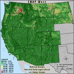
AGTSL3 - Percent total agricultural on steep slopes
The proportion of each 3 km grid cell reporting unit that has agriculture land
cover on slopes greater then 3 percent was calculated by overlaying maps of percent
slope and agricultural land cover, which included crops, pasture and orchards. The
area of agriculture on steep slopes was then divided by the total land area of the
grid cell boundary. The total agricultural land use on steep slopes can be a measure of
increased soil erosion which could also cause sediment in streams and lakes. The
potential soil erosion from agricultural lands is related to the steepness of
slopes being cultivated, soil type and the farming methods used. Agriculture on
slopes greater than 3% ranged from 0% to a little under 3% of total area in the
grid cell boundary. The proportions are lower in remote mountainous areas since less
agriculture can be found there, agriculture in this area tends to be located in
the flatter river valleys. The values seen here in the mountain
area are generally lower when compared to the central and eastern United States.
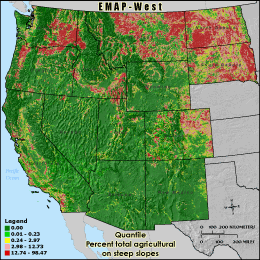
Quantile: Each class contains an approximately equal number (count) of features. A quantile
classification is well-suited to linearly distributed data. Because features are grouped by the number
within each class, the resulting map can be misleading, in that similar features can be separated into
adjacent classes, or features with widely different values can be lumped into the same class. This
distortion can be minimized by increasing the number of classes.
Natural Breaks: Classes are based on natural groupings of data values. Natural break points
are identified by looking for groupings and patterns inherent in the data. The features are divided
into classes whose boundaries are set where there are relatively large jumps in the distribution of
data values.
* EMAP-West Landscape Metrics Metadata (FGDC)
|
|