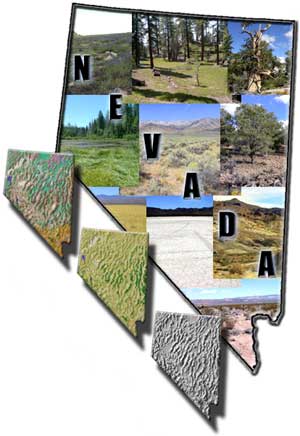
Overview
The Nevada Data Browser was developed by the Landscape Ecology Branch of the U.S. Environmental Protection Agency (Las Vegas, NV) with the assistance and collaboration of the Lockheed-Martin Environmental Services Office (Las Vegas, NV). Its purpose is to centralize and distribute the geospatial data used to create the land cover, vertebrate habitat models and land stewardship data produced for the Nevada eco-regional component of the Southwest Regional GAP Analysis Project (SW ReGAP).
The Gap Analysis Program (GAP) is a national program of the U.S. Geological Survey (USGS) Biological Resources Division that maps the distribution of plant communities and selected animal species and compares these distributions with land stewardship to identify biotic elements at potential risk of endangerment. GAP uses Geographic Information System (GIS) technology to analyze biological and land management data to identify areas (gaps) where conservation efforts may not be sufficient to maintain diversity of living natural resources.
Previous GAP projects were conducted by individual states. Differences among adjacent states in the methodologies and data used for land cover mapping commonly yielded surprisingly inconsistent vegetation and animal habitat maps. In response to these limitations, GAP is embarking on a second- generation effort to conduct the program at a regional scale, using a vegetation classification scheme applicable across the U.S., and using eco-regional units as the basis for classifying imagery. The program's first formalized multi-state regional effort includes the five states (Arizona, Colorado, Nevada, New Mexico, and Utah) comprising the Southwest Regional Gap Analysis Project.
The three basic elements of the SW ReGAP project are:
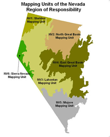
Land Cover Mapping: The SW ReGAP project used contemporary (1999-2001) Landsat 7 Enhanced Thematic Mapper imagery from three seasons, i.e. spring (leaf-on), summer (peak greenness), and fall (leaf-off). The information comprised 63 triplicate scenes for the state of Nevada and they were composited into biogeographically unique mapping units that span political boundaries of the adjacent states. Vegetation mapping was conducted at the "ecological systems" level of the National Vegetation Classification provided by NatureServe (Comer et al 2003).
Land Stewardship: The project will produce a land stewardship map of the state that indicates individual management units of public land and for private conservation lands when voluntarily provided. Each tract will be attributed for land ownership, managing institution, and management status.
Wildlife Habitat Relationships: The project will model the predicted distribution of each vertebrate species that resides, breeds, or uses habitat in each state for a substantial part of its life history, including important migration stopovers. The distribution maps will indicate predicted species presence for known, probable, and possible areas of its geographic range.
Timeline of the Nevada Eco-regional component
Sep. 2000 Nevada eco-regional component assigned to NERL-ESD-Las Vegas scientists
Feb. 2002 Land cover training data collection initiated
Aug. 2002 Literature search commences for vertebrate habitat models
Aug. 2004 Provisional land cover maps completed
Mar. 2005 Provisional vertebrate habitat models completed
Dec. 2005 GAP analysis completed; final land cover maps, vertebrate habitat models and land stewardship data released
Using the Nevada Geospatial Data Browser
For best viewing of the Nevada Geospatial Data Browser web site, the Windows desktop viewing area should be set to 1024 by 768 pixels or higher. Some 15-inch monitors may require adjustments to the desktop viewing area. If adjustment is required, do the following:
-
1. Open your Windows Control Panel
-
2. Double click on the Display icon
-
3. Select the Settings folder tab
-
4. Adjust the Desktop/Screen Area to 1024 by 768 pixels or higher
-
5. Select Apply/OK
GIS download datasets
This website contains 37 downloadable geospatial datasets of Nevada with
complete metadata. The terrestrial wildlife habitat models for 819 species
from the entire 5-state Southwest Regional GAP Analysis Project can be directly
downloaded from http://fws-nmcfwru.nmsu.edu/swregap/HabitatModels/default.htm ![]() (USGS
National Gap Analysis Program. 2005. Provisional Digital Animal-Habitat Models
for the Southwestern United States. Version 1.0. Center for Applied Spatial
Ecology, New Mexico Cooperative Fish and Wildlife Research Unit, New Mexico
State University). Approximately 520 species are estimated to occur in Nevada.
(USGS
National Gap Analysis Program. 2005. Provisional Digital Animal-Habitat Models
for the Southwestern United States. Version 1.0. Center for Applied Spatial
Ecology, New Mexico Cooperative Fish and Wildlife Research Unit, New Mexico
State University). Approximately 520 species are estimated to occur in Nevada.
All GIS Data is in the following
projection:
Projected Coordinate System: NAD_1983_Albers
Projection: Albers
False_Easting: 0.00
False_Northing: 0.00
Central_Meridian: -96.00
Standard_Parallel_1: 29.50
Standard_Parallel_2: 45.50
Latitude_Of_Origin: 23.00
Disclaimer
Users are advised that the majority of coverages within the database have been provided by a number of other agencies. Verification of the quality and use of any data supplied via this product are the responsibility of the user.
Citation
Kepner, W. G., T.D. Sajwaj, D. F. Bradford, and E. J. Evanson. 2005. Nevada Geospatial Data Browser. EPA/600/C-05/005. U.S. Environmental Protection Agency, Office of Research and Development, Las Vegas, NV (https://www.epa.gov/nerlesd1/land-sci/gap.htm).