Rangelands Information
 EMAP defined rangelands as terrestrial systems characterized by a climate regime where the potential evapotranspiration exceeds precipitation, annual precipitation ranges from less than 5 to 60 centimeters, and air temperatures range from -40 to 50 degrees centigrade. The vegetation is dominated by woody shrubs, grasses, cacti and leaf succulents, and drought resistant trees.
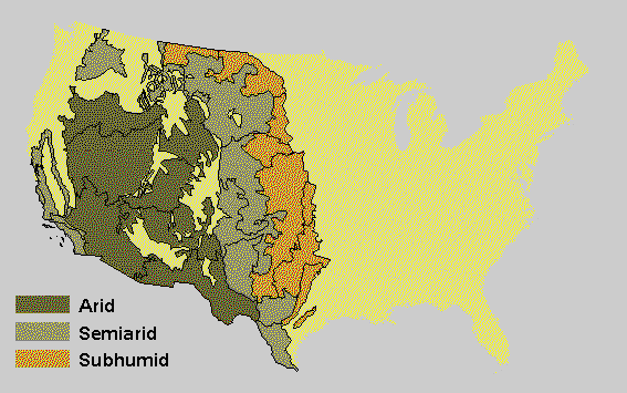
The target population for rangeland sampling included the arid, semi-arid, and subhumid regions of the conterminous United States. Rangelands include desert scrub, prairies, grasslands, chaparral, open woodland, alpine tundra, arctic desert, and riparian communities but excluded intensively managed agriculture such as irrigated farmlands.
Many individuals think of rangelands only as deserts. As noted above, however, rangelands include a diverse set of resource classes. Rangelands once comprised nearly 40% of the United States (Figure Above). As with wetlands, rangelands have been converted into other land uses such as agriculture, especially in the subhumid region. Rangelands are now estimated to comprise approximately 25% of the land in the United States. Although there has been a decline in the proportion of rangelands, they still comprise a significant portion of the landscape, particularly in the West, where almost 65% of the area is under state and federal management.
In monitoring rangelands, EMAP used a hierarchical biogeographic classification system that allowed interpretations at multiple levels of biological organization. EMAP's Rangelands Group planned to collect data using both sample-based and remotely sensed information (for example, satellite imagery) as part of their indicator research and monitoring strategy. Rangelands are predominately managed by State and Federal agencies; the U.S. Bureau of Land Management, U.S. Soil Conservation Service, U.S. Department of Agriculture Forest Service, U.S. Fish and Wildlife Service, National Park Service, and EPA cooperate in the research development, monitoring, and assessment of rangelands.