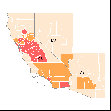
Area Designations for 1997 Ground-level Ozone Standards
Region 9: State Designations for the 1997 8-Hour Ozone Standard
Boundary Designations for the 1997 8-Hour Ozone Standard
- EPA Region 9
(as of September 18, 2009)
You will need Adobe Reader to view some of the files on this page. See EPA's PDF page to learn more.
This table identifies all counties EPA has designated as nonattainment.
In some cases EPA designated partial counties. These are identified by
a (P). If a county is not listed below, EPA has
designated it as unclassifiable/attainment. See also the table of redesignated areas.
|
State |
Nonattainment Area Name |
Counties |
April 15, 2004 Classification |
Maximum Attainment Date (from June 15, 2004) |
Current/Proposed Classification | Resdesignation Effective Date |
|---|---|---|---|---|---|---|
| Arizona 1 |
Phoenix -Mesa Map (PDF) (2 pp, 55KB) |
Maricopa (P) Pinal (P) |
Former Subpart 1 | June 2009 | Former Subpart 1 | - |
| California 1 |
Los Angeles South Coast Air Basin, CA Map (PDF) (3 pp, 118KB) |
Los Angeles (P) Orange Riverside (P) San Bernardino (P) |
Severe-17 | June 2021 | Severe-17 | - |
| Riverside Co, CA (Coachella Valley) Map (PDF) (2 pp, 76KB) |
Riverside (P) | Serious | June 2013 | Serious | - |
|
| San Joaquin Valley, CA Map (PDF) (2 pp, 135KB) |
Fresno Kern (P) Kings Madera Merced San Joaquin Stanislaus Tulare |
Serious | June 2013 | Serious | - |
|
| Amador and Calavaras Cos (Central Mountain Counties), CA Map (PDF) (1 p, 65KB) |
Amador Calaveras |
Former Subpart 1 | June 2009 | Former Subpart 1 | - |
|
| Mariposa and Tuolumne Cos (Southern Mountain Counties), CA Map (PDF) (1 p, 73KB) |
Tuolumne Mariposa |
Former Subpart 1 | June 2009 | Former Subpart 1 | - |
|
| Sacramento Metro, CA Map (PDF) (2 pp, 134KB) |
El Dorado (P) Placer (P) Sacramento Solano (P) Sutter (P) Yolo |
Serious | June 2013 | Serious | - |
|
| Nevada (Western Part), CA Map (PDF) (1 p, 68KB) |
Nevada (P) | Former Subpart 1 | June 2009 | Former Subpart 1 | - |
|
| Los Angeles-San Bernardino Cos (W Mojave Desert), CA Map (PDF) (2 pp, 102KB) |
San Bernardino (P) Los Angeles (P) |
Moderate | June 2010 | Moderate | - |
|
| Ventura Co, CA Map (PDF) (1 p, 81KB) |
Ventura (P) | Moderate | June 2010 | Serious | - |
|
| Kern Co (Eastern Kern), CA Map (PDF) (2 pp, 58KB) |
Kern (P) | Former Subpart 1 | June 2009 | Former Subpart 1 | - |
|
| San Diego, CA Map (PDF) (1 p, 65KB) |
San Diego (P) | Former Subpart 1 | June 2009 | Former Subpart 1 | - |
|
| Imperial Co, CA Map (PDF) (1 p, 43KB) |
Imperial | Marginal | June 2007 | Moderate | - |
|
| Chico, CA Map (PDF) (1 p, 41KB) |
Butte | Former Subpart 1 | June 2009 | Former Subpart 1 | - |
|
| San Francisco Bay Area, CA Map (PDF) (2 pp, 158KB) |
Alameda Contra Costa Marin Napa San Francisco Santa Clara San Mateo Solano (P) Sonoma (P) |
Marginal | June 2007 | Marginal | - |
|
| Sutter County (Sutter Buttes), CA Map (PDF) (1 p, 38KB) |
Sutter (P) | Former Subpart 1 | June 2009 | Former Subpart 1 | - |
|
| Hawaii | entire state is attainment | |||||
| Nevada 1 | Las Vegas, NV 2 Map (PDF) (2 pp, 70KB) |
Clark | Former Subpart 1 | June 2009 | Former Subpart 1 | - |
1 Includes Tribal lands
2 See the Clark County, Nevada page for correspondence relating to the boundaries and effective date of the designation.