Virtual Field Reference Data Base
The Landscape Characterization Branch within the Office of Research and Development has developed the Neuse River Basin "Virtual Field Reference Data Base (VFRDB)" for the purpose of providing in situ reference measurement data for statistically rigorous accuracy assessments of land-cover maps derived from satellite and airborne remote sensing platforms. Vegetative and physiographic components were measured on 1,409 plots (0.42 hectares) over a two-year period (1998-1999) using stringent quality assurance protocols to ensure statistical reliability and repeatability. The "virtual" component of the database is the high resolution (1,040 x 840 pixels) natural color imagery series that were acquired for each site. The U.S. Environmental Protection Agency's Office of Research and Development is making these data available to all interested parties via this website.
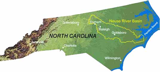
The Neuse River Basin (NRB) is contained entirely within the state boundaries of the state of North Carolina. The basin boundaries were delineated based on the U.S Geological Survey (USGS), 6-digit hydrologic unit code (030202). The NRB is 14,582 km2 in area and contains 16,900 km (1:24,000-scale) of stream length. The upper (northwestern) third of the basin is located in the piedmont physiographic region and the remainder in the mid-Atlantic coastal plain. Elevations within the NRB range from 276 meters in the western part of the basin to sea level at the confluence of the Neuse River to Pamlico Sound. The confluence represents the southern extent of the Albemarle-Pamlico Sound estuary system which is defined by a series of barrier islands called the North Carolina's Outer Banks.