Contact EPA Pacific Southwest Water Division
Pacific Southwest, Region 9
Serving: Arizona, California, Hawaii, Nevada, Pacific Islands, Tribal Nations
Nutrioso Creek Watershed
On this page:
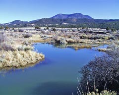
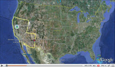
Nutrioso Creek is located in the Little Colorado River Basin in southern Apache County, along the eastern border of Arizona. The Nutrioso Creek watershed drains approximately 159 square miles, and is defined as the drainage area of land that captures and transports surface and ground water within the basin near Nutrioso, AZ (map ![]() ). The town of Nutrioso is an unincorporated community, where the population is estimated at 150 people. Nutrioso Creek was listed on Arizona’s impaired waterbody list in 1998 for not meeting state water quality standards for turbidity and is currently listed as a Measure W watershed for EPA Region 9.
). The town of Nutrioso is an unincorporated community, where the population is estimated at 150 people. Nutrioso Creek was listed on Arizona’s impaired waterbody list in 1998 for not meeting state water quality standards for turbidity and is currently listed as a Measure W watershed for EPA Region 9.
A TMDL was completed for Nutrioso Creek in 2000. Field investigations found that historic grazing and forestry practices had led to a loss of riparian vegetation and caused stream entrenchment. Healthy riparian areas are needed to stabilized stream banks and dissipate stream energy during high flow events. The TMDL identified a variety of management practices to improve cattle grazing and forestry practices. What is a TMDL?
Jim Crosswhite owns the EC Bar Ranch, which includes a three mile section of the Creek where historic overgrazing had occurred. Since 1998, Mr. Crosswhite has participated in the Arizona Department of Environmental Water Quality Improvement Grant Program by implementing water quality improvements recommended in the TMDL. In addition, Mr. Crosswhite donated a conservation easement to permanently protect water quality and aquatic wildlife habitat conditions on his property.
Adjoining the EC Bar Ranch downstream, the US Forest Service manages land within the watershed and has done implementation work using 319 funds as well.
As a result of the water quality and wildlife habitat improvements completed in the watershed, native fish populations, including a federally listed fish species, the Little Colorado Spinedace, have increased in numbers. Ongoing restoration will benefit other wildlife as well, including the endangered Southwestern Willow Flycatcher.
In 2009, DEQ and EPA removed Nutrioso from the impaired waterbody list. This is the first instance in Arizona where a waterbody has been delisted by implementing NPS BMP’s.
Watershed Implementation Activities
Water Quality Improvement Grant Projects
ADEQ awarded the following Water Quality Improvement Grants (319 Grants) in this watershed. More information concerning these grants or projects can be obtained at Arizona Department of Environmental Quality's Water Quality Improvement Grant Program. ![]()
EC Bar Ranch Turbidity Reduction Projects
Project years: 2000, 2001, 2002, 2003, 2004, and 2005, Location: Lat and Long 33 58 44, -109 12 08 (NAD 83)
Goals: Restore riparian proper functioning conditions by fencing to control livestock and elk activities, installation of off-channel drinkers, streambank restoration structures, erosion control structures, critical area grass plantings, and improved management practices to help stabilize streambanks and reduce sediment loading in Nutrioso Creek.
Rogers Ranch Turbidity Reduction Project
Project year: 2000, Location: Lat and Long 33 59 35, - 109 12 15
Goals: Control of large ungulate activities with fencing, streambank revegetation, and off-channel drinkers for livestock and wildlife to improve riparian conditions and reduce turbidity. Shortly after the grant was awarded, Mr. Crosswhite acquired the project area and completed the practices.
Greenwood Sediment Reduction Project
The Apache Sitgreaves National Forest (USFS), Project year 2001, Location: Lat and Long 34 01 58, -109 11 50)
Goals: Reconstruct and realign forest roads to reduce sediment contributions to Nutrioso Creek. Erosion stabilization techniques were applied to control active head-cutting and bank erosion caused by roads.
Data
- WATERS
(Watershed Assessment, Tracking & Environmental ResultS) unites water quality information from several independent and unconnected databases. - GRTS
The Grants Reporting and Tracking System (GRTS) is the primary tool for management and oversight of the EPA’s Nonpoint Source (NPS) Pollution Control Program.
Contact Information
- EPA Region 9
Jared Vollmer (vollmer.jared@epa.gov)
(415) 972-3447 - AZDEQ
Krista Osterberg (osterberg.krista@azdeq.gov)
(602) 771-4635 - Landowner
James W. Crosswhite
www.ECBarRanch.com
Additional Resources
- Arizona Department of Environmental Quality

- Arizona Department of Water Resources
- United States Geological Survey
- University of Arizona - NEMO
- EPA’s Watershed Central
Watershed Central has been designed to assist users to develop and implement effective watershed management programs. The site includes guidance, tools, case studies, and data sets to help you share information, analyze data, and identify opportunities to initiate or strengthen your watershed efforts. - EPA’s Watshed Webcasts
Watershed Academy Webcast Seminars