Collaboration and Partnerships
Note: EPA no longer updates this information, but it may be useful as a reference or resource.
Mystic River
EPA Region 1 - Boston
Geographic location or area of activity: Mystic River Watershed, which encompasses 21 municipalities in Greater Boston, Massachusetts.
Description of activity: The Mystic River, flowing from the Mystic Lakes just north of Boston through urban and suburban neighborhoods to Boston Harbor, is one of the great urban rivers of New England. The river once served as an epicenter of colonial activity from which sprung settlement and economic growth. The long-term effects are evident in today’s watershed and the river’s water quality. Over the years, fields have been replaced with parking lots, footpaths with highways, pastoral riverbanks with industrial activity and shipyards with oil storage facilities.
It is now time to make the Mystic River watershed into a healthy place that provides opportunity for recreational and industrial activity. EPA kicked off a new Regional Initiative in April of 2007 to improve water quality in the Mystic River by issuing a Report Card. The river received a grade of “D” for water quality because bacterial standards for swimming were being met just 52% of the time and boating standards 67% of the time. The initiative simulates prior successes on the nearby Charles River and other urban rivers and will employ strategies that have been proven to be useful in those efforts: permits, compliance assistance, and potentially, enforcement. The Mystic strategy includes cooperation with communities, local organizations and stakeholders to further develop strategies to support the watershed goals.
EPA has learned that bringing in partners from the outset is critical to forming a common vision in which all stakeholders invest. An upcoming “Summit,” to be held in early 2008, was announced on EPA’s Mystic River website. EPA hopes that the Summit will help develop goals, map a strategy and form a Steering Committee to commit restoring the River. The website, launched in the fall of 2007, offers an opportunity for interested parties to submit requests to be invited to the Summit and submit ideas for discussion topics. It also provides background information on the watershed, a list of important contacts, updates of events and activities and an invitation to become part of the solution.
EPA New England hopes that the Summit will shed light on specific historical, current and potential future uses of various parts of the River including fishing, rowing, swimming, recreational boating, etc. GIS mapping will be used to identify environmental justice concerns, potential contamination sources and monitoring sites. After the Summit, a Science Advisory Committee may be formed to guide future monitoring and laboratory strategies.
Interagency partners: US Army Corps of Engineers, US Coast Guard, US Geological Survey, Massachusetts Department of Conservation and Recreation, Massachusetts Department of Environmental Protection, Massachusetts Office of Coastal Zone Management
Local partners: Boston Water and Sewer Commission, Chelsea Collaborative
Chelsea Creek Action Group, Chelsea Green Space and Recreation Committee, Friends of Alewife Brook, Massachusetts Water Resources Authority, Mystic River Watershed Association, Watershed municipalities, EJ community Groups, Neighborhood of Affordable Housing, Tufts University, Urban Ecology Institute
Activity URL: www.epa.gov/ne/mysticriver/
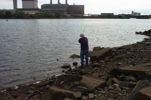
Mystic River fisherman