Collaboration and Partnerships
Note: EPA no longer updates this information, but it may be useful as a reference or resource.
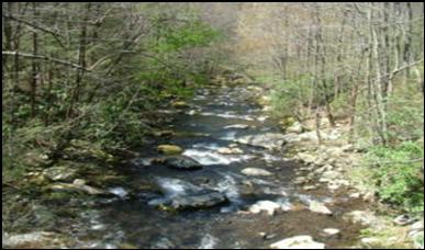
Watershed Improvement Summary-Little River Subwatershed (TN)
EPA Region 4-Atlanta
Geographic location or area of activity: The Little River sub-watershed of the Fort Loudoun Lake Watershed extends from the Smoky Mountains National Park, through Blount County, to the Fort Loudoun reservoir in Knoxville.
Description of activity: The primary pollutants in Ellejoy Creek are nitrates and pathogens caused by poor pasture management. To prevent sediment and other pollutants from entering Ellejoy Creek, Best Management Practices (BMPs) have been installed, such as, stream crossings, heavy-use feeding pad area, alternative watering systems, fencing, pipelines, streambank protection, and livestock access restriction to the creek. An environmental education initiative targeted landowners and encouraged the reductions in the volumes of pollutants caused by agricultural and construction activities within the watershed. As a result, the demand for conservation practices increased significantly.
The primary source of pollutants in Short Creek was pathogens caused by improper grazing management. Volunteers assisted in visual assessments, sampling and monitoring in the Short Creek Watershed near Townsend for two years. Several bacteriological samples were taken at various locations including near the mouth.
The Little River Watershed has leveraged the resources of several agencies and organizations in a coordinated effort to improve water quality. While progress has been made in implementing conservation practices, continued multi-organizational efforts are needed to address water quality contaminants from agricultural, urban and commercial sources.
Results of projects implemented in the Little River Watershed and its tributaries include:
15,508 feet along streambanks and 7,573 feet in woodland of livestock exclusion fencing improved
22,745 feet of cross-fencing for rotational grazing
135 feet of streambank restoration
7 acres of critical area treatment
7 heavy use areas installed
4,300 feet of cattle access lane (animal trails and walkways)
20 alternative watering facilities installed associated with heavy use area
147 acres of pasture renovation
5 stream crossings installed
The Little River Watershed
To date, the Little River partnership has aided in securing grants totaling more than $3 million. The Blount County Soil Conservation District has taken a proactive approach to environmental stewardship using local agricultural producers as educators and resulting in a 193% increase in cost-share allowances.
Interagency partners: USDA-National Resource Conservation Service; DOI-U.S. Geological Survey, U.S. Fish and Wildlife Service and National Park Service; Tennessee Valley Authority; Environmental Protection Agency; Blount County Soil Conservation District; Tennessee Department of Environment and Conservation’s Division of Water Supply and Division of Community Assistance; Tennessee Department of Agriculture
Local partners: Tennessee Izaak Walton League; Little River Watershed Association; Blount County Planning Commission; Citizens