Developing Design Structure - Site Selection & Design File
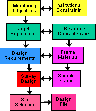 |
Following the guide for the development of a survey design for Aquatic Resource Monitoring. This step completes the Design Process by running the site selection algorithms and creating the Design File. An overview of how it fits together. Continuing with the illustrative example of the design processes based on the EMAP Western Pilot Program. See Indiana Streams for another example. |
| Completion of the design process establishes the sites to be surveyed and creates documentation for the design and analysis |  |
 |
 |
 |
|
 |
|
 |
|||
 |
|
 |
|
| Combining the Sample Frame, Survey Design, discrete grid, and GIS algorithms a spatially balanced randomize list of sites is selected. |  |
||
| A standardized Design File is created to document the design process, establish a data record with information for each site |
Site Selection Process
|
Design File: Has all sites selected by survey design, for each site:
|