Developing Design Structure - Frame Materials
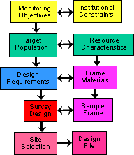 |
Following the guide for the development of a survey design for Aquatic Resource Monitoring. The next step in the process identifies the available frame materials. Continuing with the illustrative example of the design processes based on the EMAP Western Pilot Program. |
| Identifying the frame materials that provide a spatial representation and auxiliary information for all units of the target population. |  |
 |
 |
 |
|
 |
|
| Usually, the Design Process proceeds with existing frame materials |  |
||
| Although occasionally additional frame materials are needed for specific areas/features. |  |
| Partial list of potential frame materials |
|