Note: EPA no longer updates this information, but it may be useful as a reference or resource.
Summary Results of Sediment Sampling Conducted by the Environmental Protection Agency in response to Hurricanes Katrina and Rita
August 17, 2006
- Overview
- Phased Sampling And Results
- Conclusions And Recommendations
- Sediment Sampling Map
- Hurricane Katrina Diesel Range Organics/Oil Range Organics Concentration Trends
Overview
After Hurricane Katrina came ashore on the Louisiana Gulf Coast, the Environmental Protection Agency (EPA) and its Federal and State partners conducted a comprehensive investigation to characterize any potential environmental effects to the parishes that were flooded by up to 10 feet of water from Lake Pontchartrain and the Mississippi River/Gulf of Mexico outlet. Since early September 2005, EPA has collected approximately 1,800 sediment and soil samples in Jefferson, Orleans, Plaquemines, and St. Bernard Parishes in four discrete phases. Most of these samples were analyzed for over 200 metals and organic chemicals.
As each phase of sampling was completed, the results were compared to conservative health-based screening levels for residential exposure developed by EPA and Louisiana Department of Environmental Quality (LDEQ). Summaries and general assessments of the data were developed by EPA and LDEQ with input from the Centers for Disease Control (CDC), the Agency for Toxic Substances and Disease Registry (ATSDR), the Louisiana Department of Health and Hospitals (LDHH), and the Federal Emergency Management Agency (FEMA). Detailed information.
The sample results indicate that, in general, the sediments left behind by the flooding from the hurricanes are not expected to cause adverse health impacts to individuals returning to New Orleans. A few localized areas were re-assessed due to elevated levels of arsenic, lead, benzo(a)pyrene, and diesel and oil range organic petroleum chemicals. The results of these re-assessments indicated that: 1) the highest concentrations of arsenic were likely associated with herbicides used at or near golf courses; 2) benzo(a)pyrene was found in a small section of the Agriculture Street Landfill Superfund site and will be addressed as the Housing Authority of New Orleans finalizes its plans for badly damaged townhomes in the area; 3) the concentrations of diesel and oil range organic chemicals are diminishing and will be monitored over time to ensure that these concentrations continue to decrease; and, 4) the elevated levels of lead detected in samples collected by EPA predate the hurricanes. The lead results from the EPA samples are comparable to the historical concentrations of lead in soil in New Orleans found in studies conducted by local university researchers before the hurricanes.
The extensive sediment and soil sampling in response to Hurricane Katrina is complete. EPA and LDEQ have collected approximately 1,800 sediment and soil samples. This work, completed in four phases, provides an extensive picture of the conditions in the flood impacted areas, and serves as the basis for a series of recommendations and advisories provided by local government.
Phased Sampling And Results
The objectives and results of the sediment sampling are the focus of this summary. EPA Region 6 and several other Federal and State environmental and health agencies, carried out this mission assignment by collecting approximately 1,800 sediment and soil samples in four phases.
Phase I — Sediment from floodwater
Sediment sampling in Phase I began on September 10 and was completed on October 14, 2005. Approximately 450 individual samples were collected throughout the flood-impacted areas. These samples were analyzed for over 200 organic chemicals (including gasoline, diesel fuel, and oil), metals, and coliform bacteria. The data from these analyses were used to assess: 1) whether hazardous substances were present in the sediment in residential areas; and, 2) the potential health effects to emergency workers and residents from short-term exposure to any hazardous substances found in the sediment.
The results of the Phase I sampling indicated that hazardous substances were not detected in the sediments at levels that would pose an immediate health risk to workers involved in response activities or to residents returning for a quick assessment of damage to their homes. The highest levels of arsenic were found in samples taken from golf courses, which were likely from the use of herbicides containing arsenic. Lead was found in approximately 5% of the Phase I samples in concentrations comparable to the historical concentrations of lead in New Orleans.
The results from the Phase I samples were compared to both LDEQ Risk Evaluation/Corrective Action Program (RECAP) and EPA's risk criteria based on long-term (30 years) residential exposure assumptions. The majority of chemicals detected were below levels of health concern. However, there were some localized areas with levels of arsenic, polycyclic aromatic hydrocarbons (PAHs) and diesel and oil range organics that exceeded LDEQ and EPA criteria. LDEQ and EPA revisited approximately 145 previously sampled locations. For re-sampling to occur, the sediment depth had to exceed a depth of 1.5 cm (0.5"). Sediments of sufficient depth were found at 14 locations, and were re-sampled to determine conditions at that time. The results from the samples at these 14 locations are included in the summary found at the Internet site listed below.
More details on Phases I and II
Phase II — Sediment from floodwater
The second phase of sediment sampling began on October 29, 2005, focusing on the Lower Ninth Ward of New Orleans and St. Bernard Parish, the areas most severely impacted by the flooding. The objective of this phase of sampling was to define areas of concern (e.g., areas with chemical concentrations that may be associated with a greater than 1 in 10,000 excess lifetime cancer risk) larger than 3 acres. Approximately 280 individual samples were collected between October 29 and November 27 and were analyzed for the full suite of over 200 organic chemicals, metals, gasoline, oil, diesel fuel and biological constituents. Lead was the only analyte detected above screening levels in any samples collected in Phase II. Lead was found in four locations in St. Bernard Parish above the EPA and LDEQ screening value of 400 mg/kg.; EPA and LDEQ used the 400 mg/kg lead level as an indicator that further studies may be appropriate in specific areas around the city.
On December 9, 2005, LDEQ, EPA, and their State and Federal partners, released a summary environmental assessment for the areas impacted by Hurricanes Katrina and Rita based on the data collected in the Phase I and II sediment sampling events. A general characterization of the sample results and identification of areas to focus any further evaluation were included in the summary. In the assessment, LDEQ and EPA also noted that a more detailed assessment would be necessary at a few locations in the flood-impacted area based on the analytical results of the samples collected in Phases I and II.
More details on Phases I and II
Phase III — Focused sampling of flood impacted soil and sediment
Based on the results of the Phase I and II sampling, which found elevated concentrations of arsenic, lead, or benzo(a)pyrene in flood-impacted residential areas, EPA and LDEQ identified 43 specific areas for further investigation. The goal of the Phase III investigation was to determine whether the elevated levels of arsenic, lead and benzo(a)pyrene were isolated to the specific location that had been sampled, or whether they were representative of a larger area. Additionally, pesticide analyses were conducted on samples collected at the former Thompson-Hayward pesticide blending facility at the request of residents living near the abandoned facility.
Unlike previous sampling rounds, Phase III samples were collected and mixed together (i.e., composite samples) to characterize the average concentration of chemicals around the original sampling locations. These composite samples were not only of the sediment deposited by floodwaters, but also included samples of the underlying soil that existed prior to the hurricanes.
The results from these composite samples indicate that: 1) the sediment left behind by the flooding did not contain arsenic at levels that would result in non-cancer impacts or exceed EPA’s 1 in 10,000 excess lifetime cancer risk; 2) a very localized area of benzo(a)pyrene contamination is present in the northwest corner of the Agriculture Street Landfill Superfund site; and, 3) lead was found in soil samples at several locations in excess of the EPA and LDEQ screening level of 400 mg/kg.
Lead concentrations exceeded the EPA and LDEQ soil screening level for lead (400 mg/kg) in 57 of 147 composite samples collected in the areas where lead was previously detected in the samples collected in Phase I and Phase II. Lead concentrations in “soil only” samples and “soil mixed with sediment” samples collected in Orleans Parish ranged from below the 400 mg/kg screening level to 3,960 mg/kg. The highest lead levels were detected in soil samples and not in the sediment deposited from floodwaters.
Elevated lead levels in soil are common in older cities throughout the United States. EPA’s 1996 report, Distribution of Soil Lead in the Nation’s Housing Stock, estimated that 23 percent of privately owned homes in the US built before 1980 had soil-lead levels above 400 mg/kg, and that 3 percent had levels exceeding 5,000 mg/kg. In New Orleans, researchers from Xavier University reported soil lead levels as high as 4298 mg/kg prior to Hurricane Katrina (PAH and Metals Mixtures in New Orleans Soil and Sediment, The Science of the Total Environment, Mielke et al., 2001). The concentrations of lead found by EPA are consistent with the results from the Xavier University study.
The geographic pattern of sample locations that exceeded the soil screening level for lead (400 mg/kg) appears to correspond to older housing (built before 1978) that can contain interior and exterior lead-based paint. To further characterize the locations that exceeded the soil screening level of 400 mg/kg, samples from these locations were evaluated to identify the potential sources of lead contamination, such as lead-based paint, through a chemical speciation process. The results of the speciation study suggest that the primary source of lead in the soil samples collected by EPA is lead-based paint, followed by other anthropogenic sources which include solder, leaded glass and pesticides, as well as from the historical deposition of lead from leaded gasoline emissions.
More details on Phase III sampling
Phase IV — Sampling of Residual Sediment in flood impacted areas
Also in February 2006, EPA began a fourth phase of sampling, focusing on heavily impacted residential areas in Orleans and St. Bernard parishes. EPA used the results of this investigation for two purposes. First, EPA has generated a map indicating where sediment remains and where sediment no longer exists. Second, EPA updated the sediment database with recent analytical results. This sampling effort was completed on June 30, 2006. EPA visited 1,676 locations set up on a 200 foot grid in the eastern half of the flooded area and collected samples from 586 of these locations. Duplicate samples were collected at 126 of these locations, resulting in 712 samples sent for analysis. Samples were not collected at the other 1,090 grid points for one of three reasons: 1) the grid point was in a commercial area, 2) the sediment was less than 0.5 cm thick; or, 3) sediment was not found.
The results from the sediment samples collected in Phase IV are consistent with the results of the samples collected in the previous phases of sampling. The sediments remaining in the flood-impacted areas are not expected to cause adverse health impacts provided people use good personal hygiene practices. Arsenic, lead, and benzo(a)pyrene were each detected in only one sample in concentrations exceeding the EPA excess lifetime cancer risk range of 1 in 1,000,000 to 1 in 10,000 for arsenic and benzo(a)pyrene and the 400 mg/kg soil screening level for lead.
More details on Phase IV sampling
Diesel and Oil Range Organic Hydrocarbons
Diesel and oil range organic hydrocarbons concentrations are expected to decrease over time through a combination of natural degradation and sediment displacement or removal. Petroleum chemicals associated with oil and diesel fuel were found in concentrations above the Louisiana RECAP values in approximately 150 samples collected during all the phases of sediment sampling, excluding the Murphy Oil spill. EPA has compared the concentrations of oil and diesel range organic chemicals from samples collected in September 2005 with the concentrations of the same chemicals found in samples collected at the same location in November 2005. EPA conducted a similar analysis of co-located samples collected in February, March and June 2006. The results of this analysis indicate that the concentrations of these chemicals are decreasing over time through a combination of factors including natural degradation processes and sediment displacement or removal at all but one location (See Table of Concentration Trends). Future sampling will be conducted to ensure that the concentrations of petroleum hydrocarbons continue to decrease over time.
Conclusions And Recommendations
The extensive sampling in response to Hurricane Katrina is complete. EPA and LDEQ have collected approximately 1,800 sediment and sediment/soil samples since the hurricane flooded New Orleans and the surrounding parishes. This work, completed in four phases, provides an extensive picture of the conditions in the flood impacted areas, and serves as the basis for the series of recommendations and advisories provided by local government outlined in this section.
EPA has contacted the property owners/managers, the Housing Authority of New Orleans (HANO) regarding the benzo(a)pyrene results from EPA’s sampling. The townhomes located in this isolated area of the site were heavily damaged by flooding and wind. EPA will work with HANO to ensure that future plans to address the damaged properties will also address contamination found by the EPA sampling. EPA will provide a closeout report when HANO announces specific plans for the area.
The New Orleans Health Department and the State of Louisiana have provided general guidance and precautions for returning residents regarding the diesel and oil range organic chemicals detected. These include:
- Till sediment into existing soil;
- Re-establish and maintain grass and flower beds;
- Remove sediment from driveways and walkways to help minimize wind-blown dust; and/or,
- Minimize dirt and dust inside homes.
EPA believes the best course of action for diesel and oil range organics is to allow the recommendations from the Health Department and the State of Louisiana to work. EPA will resample 10% of the areas where diesel and/or oil range organics concentrations exceeded the Louisiana RECAP values in six months to confirm that the concentrations continue to decrease as expected. EPA will continue to use the Louisiana RECAP values to compare the results from future samples.
Because of the historical problems with lead-based paint and elevated lead levels in soil, federal, state and local government agencies have recommended for years that all children under the age of 6 years old living in New Orleans should be tested for lead. In 2000, 14 percent of the children tested in New Orleans had elevated blood lead levels of greater than 10 micrograms of lead per deciliter of blood. The Louisiana Childhood Lead Poisoning Prevention Program and the New Orleans Health Department (NOHD) provide information on how families can decrease the risk of lead exposure and where to get a blood lead test. NOHD also received a grant from the U.S. Conference of Mayors to develop a Lead-Safe House. The New Orleans Lead-Safe House was the first of its kind in the U.S. and is used to temporarily house families while their homes undergo lead abatement. The following are recommendations that state and federal Lead Poisoning Prevention Programs have developed to help parents protect their children from exposure to lead in the home and in their neighborhoods.
In the home:
- Keep children away from peeling paint inside the home.
- When cleaning up around homes in affected neighborhoods, shower and change clothes after finishing work and before playing with your children.
- Place washable doormats or rugs at all entries of your home. Have everyone wipe their feet or leave their shoes at the door to ensure lead-containing dust will not be tracked into the house.
- Wash doormats, rugs, cleaning rags, and work clothes separately from other family laundry.
- Frequently wash a child’s hands, especially after playing outside, before they eat, and at bedtime.
- Do not let children put dirty hands, toys or other items that might have dust on them in their mouths.
- When cleaning the home, wet-mop floors and damp-wipe surfaces.
Outside the home:
- Keep children from playing in bare dirt. Cover bare dirt with grass, bushes, or 4-6 inches of lead-free wood chips, mulch, soil, or sand.
- Keep young children away from areas, such as old fences or houses, where paint is peeling, chipping, chalking, cracking or damaged.
Sediment Sampling Map
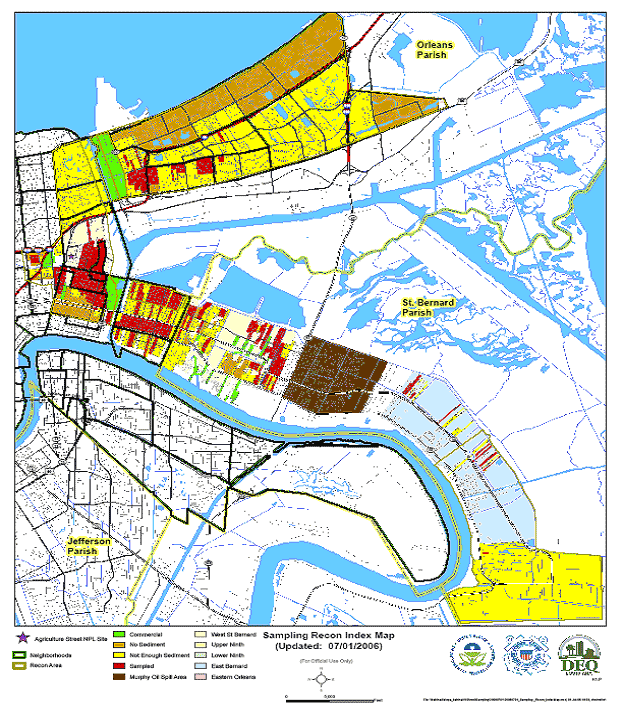
Download PDF of Sediment Sampling Map (1 pp, 742 KB, About PDF)
Hurricane Katrina Diesel Range Organics/Oil Range Organics Concentration Trends
The data presented in the table below are taken from samples collected at the same location in September and November 2005. Data from samples collected at three locations in February/March and June 2006 was also reviewed. Overall, the data indicate that Diesel Range Organic and Oil Range Organic compounds are decreasing due to a combination of processes including natural degradation and sediment displacement or removal. (The last pair of data points is an exception. Those data show an increase from February to June).
SAMPLE ID |
SAMPLE DATE |
DRO (mg/kg) |
% DRO DECREASE |
ORO (mg/kg) |
% ORO DECREASE |
|
|
|
|
|
|
RS-155-SO-G-N-091405 |
9/10/2005 |
910 |
|
1450 |
|
TO456-051119-02-RS01-N |
11/19/2005 |
82.5 |
91 |
145 |
90 |
|
|
|
|
|
|
RS152-SO-G-N-091405 |
9/14/2005 |
1890 |
|
* |
|
TO456-051119-04-RS01-N |
11/19/2005 |
115 |
94 |
* |
|
|
|
|
|
|
|
RS908-DB-G-N-092505 |
9/25/2005 |
1010 |
|
2310 |
|
TO456-051119-03-RS01-N |
11/19/2005 |
49 |
95 |
111 |
95 |
|
|
|
|
|
|
SS307-TS-G-N-092605 |
9/26/2005 |
793 |
|
1200 |
|
T0456-051119-06-RS01-N |
11/19/2005 |
632 |
20 |
335 |
72 |
|
|
|
|
|
|
RS536-TD-G-N-091905 |
9/19/2005 |
799 |
|
1430 |
|
TO456-051119-02-RS01-N |
11/19/2005 |
130 |
84 |
782 |
45 |
|
|
|
|
|
|
RS453-SO-G-N-091405 |
9/14/2005 |
3250 |
|
5540 |
|
T0456-051119-01-RS01-N |
11/19/2005 |
127 |
96 |
400 |
93 |
|
|
|
|
|
|
RS405-AD-G-N-091405 |
9/14/2005 |
887 |
|
* |
|
TO442-051119-02-RS01-N |
11/19/2005 |
48.5 |
95 |
* |
|
|
|
|
|
|
|
RS531-TD-G-N-091805 |
9/18/2005 |
742 |
|
1120 |
|
TO442-051119-01-RS01-N |
11/19/2005 |
203 |
73 |
113 |
90 |
|
|
|
|
|
|
TO442-050927-09-RS01-N |
9/27/2005 |
884 |
|
1640 |
|
TO442-051120-01-RS01-N |
11/20/2005 |
23.5 |
97 |
52.2 |
97 |
|
|
|
|
|
|
RS510-TD-G-N-091605 |
9/16/2005 |
1000 |
|
2110 |
|
TO297-051120-01-RS01-N |
11/20/2005 |
447 |
55 |
1030 |
51 |
|
|
|
|
|
|
TO232-050930-10-RS01-N |
9/30/2005 |
1230 |
|
2170 |
|
TD456-051112-02-SD01-N |
11/12/2005 |
107 |
83 |
346 |
84 |
|
|
|
|
|
|
RS062-TD-G-N-091205 |
9/12/2005 |
748 |
|
1870 |
|
TO335-051110-08-SD01-N |
11/10/2005 |
123 |
84 |
212 |
89 |
|
|
|
|
|
|
RS404-KK-G-N-092605 |
9/26/2005 |
2690 |
|
6560 |
|
TO297-051119-01-RS01-N |
11/19/2005 |
62.1 |
98 |
132 |
98 |
|
|
|
|
|
|
RS401-KK-G-N-092505 |
9/25/2005 |
779 |
|
2260 |
|
TO335-051110-01-SD01-N |
11/10/2006 |
55.5 |
93 |
67.1 |
97 |
|
|
|
|
|
|
T1235-060212-05-RS01-N |
2/12/2006 |
1700 |
|
3550 |
|
T1332-060606-02-RS01-N |
6/6/2006 |
138 |
92 |
538 |
85 |
|
|
|
|
|
|
T1168-060311-01-RS01-N |
3/11/2006 |
1290 |
|
4530 |
|
T1332-060606-03-RS01-N |
6/6/06 |
108 |
92 |
478 |
89 |
|
|
|
|
|
|
T1168-060311-02-RS01-N |
3/11/2006 |
4060 |
|
14000 |
|
T1332-060606-04-RS01-N |
6/6/2006 |
138 |
96 |
538 |
96 |
|
|
|
|
|
|
T1235-060222-05-RS01-N** |
2/22/2006 |
1360 |
|
3060 |
|
T1332-060606-01-RS01-N** |
6/6/2006 |
1410 |
|
3230 |
|
* ORO concentrations were below LDEQ’s RECAP Management Option -1 cleanup standard of 1800 mg/kg in both samples collected at that location.
** EPA believes that the DRO and ORO concentrations have not decreased at this location due to the presence of an oily material reported by the EPA field sampling team along the fence line adjacent to this sample location.