ReefLink Database

Marine Protected Areas
Marine Protected Areas (MPAs) are Any area of the marine environment that has been reserved by federal, state, tribal, territorial, or local laws or regulations to provide lasting protection for part or all of the natural and cultural resources therein (EO 2000).
CMap
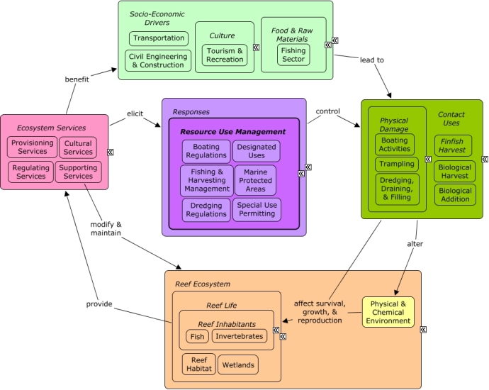
CMap Description
A change in the provision of ecosystem services, or a desire to improve provision of ecosystem services, may elicit responses to reduce or manage contact uses that include harvesting or physical damage to reef species. Among the most used management responses for coral reefs is the Marine Protected Area. There are many types of MPAs, including national marine sanctuaries, national parks and wildlife refuges, state parks and conservation areas, and a variety of fishery management closures. MPAs vary in what is protected, the size of the area protected and the form of enforcement. Many of the same socio-economic sectors that create pressures through contact uses benefit from goods and services provided by the reef, including recreational opportunities and seafood.Citations
More than 50 citations. Click here to load.
| Citation | Year | Study Location | Study Type | Database Topics |
|---|
Management Options
| Management Option | Description | Sources | Database Topics |
|---|---|---|---|
| Administrative & Interagency Policy: Continued Staff Training | It is important that staff be properly educated and trained to perform their designated tasks, but it is equally important to keep staff familiar with applicable agency directive and regulation through training and communication. Some strategies for this include information technology-based reference and guidance, regularly scheduled meetings (#210), and through in-service trainings. | NOAA Marine Sanctuary Program. 2007. Florida Keys National Marine Sanctuary revised management plan. National Ocean Service, Key West, FL. |
Beaches & Nature Parks; Collaboration & Partnering; Decision Support; Education & Information; Environmental Education & Outreach; Marine Protected Areas; Museums, Amusement Parks, Historical Sites; Public Administration; Security & Public Administration Policies; Tourism & Recreation; Travel Services & Tour Operators |
| Administrative & Interagency Policy: Conduct Staff Meetings | Several types of staff meetings should be regularly scheduled to fulfill a variety of purposes. Management meetings are necessary to address administrative policy matters. Internal staff meetings should be conducted to ensure necessary information is communicated among staff as to any changes, concerns, or developments. Meetings are an opportunity to review the sanctuary management plan (#213) and standard operating procedures (#208). External collaborators should be involved in meetings when an issue is being discussed that the collaborator is involved in, such as when standard operating procedures are being developed across agencies. Meetings can also be used as important staff training sessions. | NOAA Marine Sanctuary Program. 2007. Florida Keys National Marine Sanctuary revised management plan. National Ocean Service, Key West, FL. |
Beaches & Nature Parks; Collaboration & Partnering; Decision Support; Education & Information; Environmental Education & Outreach; Marine Protected Areas; Museums, Amusement Parks, Historical Sites; Public Administration; Security & Public Administration Policies; Travel Services & Tour Operators |
| Conducting Socioeconomic Research: Support science of socioeconomic analysis of marine protected areas | Little is known about applied socioeconomic analysis to marine protected areas. Funding support will be provided for scientists to meet and share information on this subject. | NOAA Marine Sanctuary Program. 2007. Florida Keys National Marine Sanctuary revised management plan. National Ocean Service, Key West, FL. |
Contact Uses; Economic Markets & Policies; Funding & Incentives; Infrastructural Policies; Infrastructure; Marine Protected Areas; Pressures; Public Administration; Resource Use Management; Responses; Sectors Filling Human Needs; Security; Security & Public Administration Policies; Socio-Economic Drivers |
| Dissemination of Findings: Distribute Periodic Sanctuary Health Reports | The management option involves creating monitoring/condition reports on the health of the sanctuary and reef that is released for the public. The findings can be released through newsletters, presentations, reports, publications, and other written and oral methods. Criteria reported on typically include water quality, critical habitats, and species of particular interest. These reports will ultimately help reveal the effectiveness of marine protections and policies based on the conditions researched. | NOAA Marine Sanctuary Program. 2007. Florida Keys National Marine Sanctuary revised management plan. National Ocean Service, Key West, FL. |
Biological Monitoring, Mapping, & Scientific Research; Chemical Variables; Collaboration & Partnering; Cultural Protections; Decision Support; Designate Protected Species; Ecosystem Monitoring & Restoration; Education & Information; Educational & Research Opportunities; Environmental Education & Outreach; Environmental Monitoring, Mapping, & Scientific Research; Landscape Conservation & Restoration; Marine Protected Areas; Physical & Chemical Water Quality Criteria; Physical Variables; Provisioning Services; Resource Use Management; Socio-Economic Drivers; Tourism & Recreation |
| Injury Prevention: Foster Reef Resilience | Resilience relates to how well the reef ecosystem is able to maintain key functions and processes while under abnormal pressure or stress. Two ways of supporting coral reef resilience are: incorporating known resilient areas into management design and by implementing strategies to either reinstate or protect factors that contribute to resilience, such as good environmental conditions, biological diversity, and connectivity. | Marshall, P. and H. Schuttenberg. 2006. A reef manager's guide to coral bleaching. |
Biological Monitoring & Restoration; Contact Uses; Coral; Decision Support; Discharges; Ecosystem Monitoring & Restoration; Landscape Changes; Marine Protected Areas; Pressures; Resource Use Management |
| Marine Zoning: Wildlife Management Areas (WMAs) | Wildlife Management Areas include bird nesting, resting, or feeding areas, turtle nesting beaches, and other sensitive habitats including shallow flats that are important feeding areas for fish. These areas seek to provide protection for endangered/threatened species or their habitats while at the same time providing opportunity for public use. Wildlife Management Areas are achieved through placing and maintaining buoys along zone boundaries; implementing management responsibilities; adjusting existing zone boundaries if needed; evaluating allowable activities within the boundaries and make changes if needed; identifying potential areas that need additional zoning; monitoring the effectiveness of current zones; and revising GIS and NOAA charts. | NOAA Marine Sanctuary Program. 2007. Florida Keys National Marine Sanctuary revised management plan. National Ocean Service, Key West, FL. |
Accidental & Illegal Harvest; Beaches & Nature Parks; Biological Harvest; Biological Monitoring & Restoration; Boating Activities; Coastal Defense; Contact Uses; Cultural Services; Decision Support; Designate Protected Species; Designated Uses; Ecosystem Monitoring & Restoration; Entertainment & Accommodation Services; Environmental Monitoring & Restoration; Fisheries & Hunting Policies; Fishing & Harvesting Management; Fishing Sector; Landscape Conservation & Restoration; Marine Birds; Marine Protected Areas; Permitting & Zoning; Physical Damage; Recreational Fishing; Recreational Opportunities; Resource Use Management; Sea Turtles; Tourism & Recreation; Trampling; Water Transportation; Wetlands |
| Marine Zoning: Utilize Marine Protected Areas for Research and Monitoring | Research and monitoring of marine protected areas determine the degree to which the zones meet goals and objectives for protecting natural resources, as well as human-use patterns, attitudes and compliance. Once data is gathered from within the protected zone it can than be compared to comprable data from outside the protected zone, as a control. It is necessary to compile and review data on use patterns to determine where additional Special-Use Areas would be appropriate. Research in the protected area should be non-invasive. It is important to make the protected area available for external research as well. | NOAA Marine Sanctuary Program. 2007. Florida Keys National Marine Sanctuary revised management plan. National Ocean Service, Key West, FL. |
Biological Harvest; Biological Monitoring & Restoration; Biological Monitoring, Mapping, & Scientific Research; Collaboration & Partnering; Contact Uses; Decision Support; Designated Uses; Discharges; Ecosystem Monitoring & Restoration; Educational & Research Opportunities; Environmental Monitoring & Restoration; Fish; Invasive Species; Invertebrates; Landscape Changes; Marine Protected Areas; Marine Vertebrates; Permitting & Zoning; Physical Damage; Resource Use Management; Special Use Permitting; Wetlands |
| Marine Zoning: Special Use Areas | Special use areas are set aside for specific scientific or educational purposes. This is in order to encourage the recovery or restoration of injured or degraded resources. Also, the areas may be designated to facilitate access to, or use of, resources, and prevent other user conflicts. Special-use areas are achieved through a variety of methods such as: placing/maintaining buoys along zone boundaries; adjusting boundaries if necessary; evaluating allowable activities within zone boundaries; identifying potential areas that need additional zoning; reviewing the effectiveness of the zoning; and revising NOAA and GIS charts; and determining/establishing appropriate zones for high-impact or user-conflict activities. | NOAA Marine Sanctuary Program. 2007. Florida Keys National Marine Sanctuary revised management plan. National Ocean Service, Key West, FL. |
Biological Addition; Biological Harvest; Biological Monitoring & Restoration; Biological Monitoring, Mapping, & Scientific Research; Biomedical Research Policies; Complex Habitat & Resources; Contact Uses; Cultural Services; Decision Support; Designated Uses; Ecosystem Monitoring & Restoration; Education & Information; Educational & Research Opportunities; Environmental Education & Outreach; Environmental Monitoring & Restoration; Environmental Monitoring, Mapping, & Scientific Research; Health Policies; Marine Protected Areas; Permitting & Zoning; Physical Damage; Provisioning Services; Resource Use Management; Scientific Research; Social Organizations; Special Use Permitting; Supporting Services; Wetland & Reef Restoration |
| Marine Zoning: Sanctuary Preservation Areas (SPAs) | This is a type of Marine Zoning used by the Florida Keys National Marine Sanctuary (FKNMS). SPAs focus on the protection of shallow, heavily used reefs where conflicts occur between user groups, and where concentrated visitor activity leads to resource degradation. They are designed to enhance the reproductive capabilities of renewable resources, protect areas critical for sustaining and protecting important marine species, and reduce user conflicts in high-use areas. This is accomplished through a prohibition of consumptive activities within these areas. They have been chosen based on the status of important habitat, the ability of a particular area to sustain and protect the habitat, the level of visitor use, and the degree of conflict between consumptive and non-consumptive users. The actual size and location of these zones have been determined by examination of user patterns, aerial photography, and ground-truthing of specific habitats. | NOAA Marine Sanctuary Program. 2007. Florida Keys National Marine Sanctuary revised management plan. National Ocean Service, Key West, FL. |
Accidental & Illegal Harvest; Anchoring & Vessel Grounding; Aquaculture; Aquarium & Pet Trade; Aquarium Stock; Artisanal Fishing; Beaches & Nature Parks; Biological Addition; Biological Harvest; Biological Monitoring & Restoration; Boat Movement; Boating Activities; Boating Regulations; Coastal Defense; Coastal Development; Coastal Engineering; Commercial Fisheries; Commercial Fishing Boats; Complex Habitat & Resources; Cruise Ships; Cultural Services; Decision Support; Designated Uses; Dive, Snorkeling, & Swimming Tourism; Dredging Regulations; Dredging, Draining, & Filling; Ecosystem Monitoring & Restoration; Educational & Research Opportunities; Entertainment & Accommodation Services; Environmental Monitoring & Restoration; Finfish & Shellfish Stock; Finfish Harvest; Fisheries & Hunting Policies; Fishing & Harvesting Management; Fishing Sector; Invertebrate Harvest; Landscape Changes; Large Ships; Live Collection; Marine Protected Areas; Oil & Gas Tankers; Ornamental Jewelry & Art; Permitting & Zoning; Physical Damage; Public Administration; Recreational Fishing; Recreational Opportunities; Resource Use Management; Security; Small Boats; Souvenir & Decorative Trade; Supporting Services; Tourism & Recreation; Tourism & Recreation Policies; Trampling; Travel Services & Tour Operators; Trawling & Fishing Gear Damage; Water Resources; Water Transportation |
| Marine Zoning: Existing Management Areas | The Florida Keys National Marine Sanctuary (FKNMS) uses this zoning category to identify areas that are managed by other agencies where restrictions already exist. These zones delineate the existing jurisdictional authority of other agencies (i.e., State parks, aquatic preserves, sanctuaries, and other restricted areas). Management of these areas within the Sanctuary may require additional regulations or restrictions to adequately protect resources. Any additional management measures will be developed and implemented in coordination with the agency having jurisdictional authority. Their function is not to establish another layer of bureaucracy, but to recognize established management areas and, at a minimum, to complement the existing management programs, ensuring cooperation and coordination with other agencies. Existing Management Areas will be maintained through revising GIS and NOAA charts. | NOAA Marine Sanctuary Program. 2007. Florida Keys National Marine Sanctuary revised management plan. National Ocean Service, Key West, FL. |
Accidental & Illegal Harvest; Beaches & Nature Parks; Biological Harvest; Biological Monitoring & Restoration; Boating Activities; Coastal Defense; Contact Uses; Decision Support; Designate Protected Species; Designated Uses; Ecosystem Monitoring & Restoration; Entertainment & Accommodation Services; Environmental Education & Outreach; Environmental Monitoring & Restoration; Fisheries & Hunting Policies; Fishing & Harvesting Management; Marine Protected Areas; Permitting & Zoning; Recreational Fishing; Resource Use Management; Tourism & Recreation; Water Transportation |
| Marine Zoning: Ecological Reserves (ERs) | Ecological Reserves set aside areas with minimal human interference. These reserves aim to enhance and protect biodiversity through encompassing large, contiguous habitats. The goal of ecological reserves is to encourage spawning, nurseries, and residence areas that contribute to genetic protection of fish and marine life. Ecological Reserves can be achieved through a variety of methods such as: placing/maintaining buoys along zone boundaries; adjusting boundaries if necessary; evaluating allowable activities within zone boundaries; identifying potential areas that need additional zoning; reviewing the effectiveness of the zoning; and revising NOAA and GIS charts. | NOAA Marine Sanctuary Program. 2007. Florida Keys National Marine Sanctuary revised management plan. National Ocean Service, Key West, FL. |
Biochemical & Genetic Resources; Biological Addition; Biological Harvest; Biological Monitoring & Restoration; Boating Activities; Boating Regulations; Coastal Defense; Commercial Fishing Boats; Complex Habitat & Resources; Cruise Ships; Decision Support; Designated Uses; Dredging Regulations; Dredging, Draining, & Filling; Ecosystem Monitoring & Restoration; Environmental Monitoring & Restoration; Finfish Harvest; Fisheries & Hunting Policies; Fishing & Harvesting Management; Fishing Sector; Invertebrate Harvest; Large Ships; Live Collection; Marine Protected Areas; Oil & Gas Tankers; Permitting & Zoning; Physical Damage; Provisioning Services; Resource Use Management; Security Policies; Small Boats; Tourism & Recreation; Trampling; Water Transportation |
| Monitor & Research: Utilize Managed Areas for Socioeconomic Research | Data are needed to test hypotheses about the socioeconomic impact of marine zoning and user-group perceptions about changes in natural resources within the sanctuary area. User-group perception of changes in natural resources can be compared with quantitative ecological data to identify misconceptions and knowledge gaps. Providing funding opportunities for external scientists to conduct research in the managed area is another option. | NOAA Marine Sanctuary Program. 2007. Florida Keys National Marine Sanctuary revised management plan. National Ocean Service, Key West, FL. |
Contact Uses; Cultural Services; Culture; Decision Support; Designated Uses; Economic Markets & Policies; Ecosystem Monitoring & Restoration; Educational & Research Opportunities; Environmental Education & Outreach; Food & Raw Materials; Infrastructural Policies; Landuse Management; Marine Protected Areas; Monetary Valuation; Non-Monetary Valuation; Permitting & Zoning; Provisioning Services; Reef Habitat; Reef Inhabitants; Regulating Services; Resource Use Management; Special Use Permitting; Supporting Services; Valuation |
| Monitor & Research: Monitor Sanctuary Use Patterns and Resource Value | This management option seeks to provide data and analysis of consumptive and non-consumptive use of all natural resources within sanctuary borders. Special emphasis is to be placed on artificial and natural reef resources used by residents and visitors. Wherever possible, market and non-market values of these resources should be elicited as well. | NOAA Marine Sanctuary Program. 2007. Florida Keys National Marine Sanctuary revised management plan. National Ocean Service, Key West, FL. |
Biological Monitoring & Restoration; Contact Uses; Coral; Cultural Services; Economic Markets & Policies; Ecosystem Monitoring & Restoration; Marine Protected Areas; Monetary Valuation; Non-Monetary Valuation; Provisioning Services; Reef Habitat; Resource Use Management; Tourism & Recreation Policies; Valuation |
| Resource Use Management: Fisheries Management Enforcement | Marine protected areas and other types of coastal zone management areas have fisheries management policies that must be enforced in addition to the broader Statues, Regulation and Permit Requirements (#91). Illegal, unregulated and unreported (IUU) fishing is a major problem worldwide. Management area policies must be enforced to have an impact on the fisheries stock. | Accidental & Illegal Harvest; Artisanal Fishing; Biological Harvest; Boating Activities; Boating Regulations; Commercial Fisheries; Decision Support; Designated Uses; Ecosystem Monitoring & Restoration; Finfish Harvest; Fishing & Harvesting Management; Fishing Sector; Invertebrate Harvest; Live Collection; Marine Protected Areas; Mitigation; Permitting & Zoning; Physical Damage; Public Administration; Recreational Fishing; Resource Use Management; Security Policies; Special Use Permitting; Tourism & Recreation; Trawling & Fishing Gear Damage |
Laws
| Legal Citation | Purpose of Law | Management Organization | Database Topics |
|---|---|---|---|
| 25 Virgin Islands Code. | Under Title 25, in addition to requirements for boat registration and administration of harbors, among other things, sections pertaining to the mooring and anchoring of vessels and houseboats provide for the protection of important marine resources in USVI waters. The Law requires mandatory boating education and safety courses for all boat operators. Application to Coral Reefs:Mooring and anchoring are restricted and not allowed near fragile systems. Not anchoring on coral reefs is abig plus of this legislation. Legislative Actions:Penalties for violation of the Chapter include fines not to exceed $1,000, a lien on the vessel and potential libel suit Comments:A houseboat or vessel is allowed to moor or anchor only in those areas designated by the Department. Section 404(g) of the legislation lists areas designated as areas of special concern. |
US Virgin Islands, Department of Planning and Natural Resources, Division of Environmental Protection Jurisdiction: US Virgin Islands |
Boating Regulations; Commercial Fishing Boats; Cruise Ships; Environmental Education & Outreach; Large Ships; Mangroves; Marine Protected Areas; Oil & Gas Tankers; Resource Use Management; Seagrasses; Small Boats; Transportation Policies |
| Abandoned Shipwreck Act of 1987, 43 United States Code §§ 2101-2106. | To establish title to certain abandoned shipwrecks. U. S. Government asserted three categories of abandoned shipwrecks; embedded in a State's submerged lands, embedded in corralline formations protected by a State on its submerged lands, located on a State's submerged lands and included or determined eligible for inclusion in the National Register of historic Places. Application to Coral Reefs:The Act requires, but is not limited to, development by NPS of guidelines for States and Federal agencies to develop appropriate and consistant policies to protect national resources and habitat areas, and to provide for public and private sector recovery consistant with historical values and environmental integrety. Corralline structures are specifically protected by the Act. Legislative Actions:Specific response will vary from Federal agency to Federal agency and State to State. Comments:The NPS published non-binding, advisory guidelines for States and Federal agencies to establish, review, revise, and implement programs to manage shipwrecks under their ownership or control. The guidance is entitled "Abondoned Shipwreck Act Guidelines." |
National Park Service Jurisdiction: United States; US State Waters |
Artificial Habitat; Coral; Designated Uses; Marine Protected Areas; Public Administration; Resource Use Management; Tourism & Recreation Policies; Waste Management Policies; Wetlands |
| American Antiquities Act of 1906, 16 United States Code §§ 431-433. | The Act provides penalties for unauthorized collection, excavation, or destruction of historic or prehistoric ruins, monuments, or objects of antiquity on lands owned or controlled by the United States. It authorized that areas of extrodinary geographical, historical , aesthetic value can be designated national monuments. Application to Coral Reefs:Has been used by Presidential Proclamation in 2001 to expand or create two national monuments; the Virgin Islands Coral Reef Monument and the Buck Island Reef National Monument. The monuments include coral reefs. Legislative Actions: Comments: |
National Park Service Jurisdiction: United States |
City Planning; Coastal Development; Coastal Engineering; Construction Codes & Projects; Coral; Docks & Marinas; Landscape Conservation & Restoration; Marine Protected Areas; Oil & Gas Research & Exploration; Ports & Harbors; Resource Use Management |
| Chapter 1: Wildlife including protected areas, 12 Virgin Islands Code. | Regulates hunting, including for migratory birds, wildlife restoration, establishes and regulates wildlife and marine sactuaries and game preserves. Application to Coral Reefs:The coral reefs of the US Virgin Islands are within the boundaries off the marine sanctuaries and therefore have the same protection that marine sanctuaries have. Special licenses are required for scientific investigation and for collectors. In wildlife and marine sanctuaries, except under proper permit, taking or posessing any bird, fish, or other wildlife is illegal. Discharge of a firearm or release of arrows (spearfishing) in wildlife or marine sanctuaries is illegal. No form of waste can be thrown, placed or deposited in a wildlife or marine sanctuary. Legislative Actions:The Commissioner or any USVI resident can commence a civil action. Civil penalties for violators are not to exceed $50,000 per day. Any knowingly or negligently discharging polluants can be crimimnally punished with a fine of not less than $5,000 nor more Comments:Commissioner of Planning and Natural Resources can designate and establish wildlife and marine sanctuaries, and accept monitary and animal donations from the United States. |
US Virgin Islands, Department of Planning and Natural Resources, Division of Environmental Protection Jurisdiction: US Virgin Islands |
Accidental & Illegal Harvest; Arthropods; Bivalves; Complex Habitat & Resources; Educational & Research Opportunities; Environmental Monitoring, Mapping, & Scientific Research; Existence Value & Sense of Place; Fish; Invertebrates; Lobster, Crab, & Shrimp; Mangroves; Marine Protected Areas; Marine Vertebrates; Molluscs; Octopus & Squid; Recreational Opportunities; Reef Inhabitants; Reef Life; Resource Use Management; Seagrasses; Snails & Conch; Tourism & Recreation Policies; Wetlands |
| Chapter 21: Virgin Islands coastal zone management, 12 Virgin Islands Code. | Protect, maintain, preserve and, where feasible, enhance and restore, the overall quality of the environment in the coastal zone, the natural and man-made resources therein, and the scenic and historic resources of the coastal zone for he benefit of residents of and visitors of the USVI Application to Coral Reefs:The Legislature stated coastal zone protection will conserve ecologically significant resource areas for their contribution to marine productivity and value as wildlife habitats, and preserve the function and integrity of reefs, marine meadows, salt ponds, mangroves and other significant natural areas. The legislation will also maintain or increase coastal water quality through control of erosion, sedimentation, runoff, siltation and sewage discharge. Legislative Actions:Any violation of the chapter will be grounds for revocation or suspension of coastal zone permit and an order to cease and desist. Any person who violates any provision of the chapter shall be subject to a civil fine not to exceed $10,000 per day. Exemplary damages may be assessed at the discretion of the court. Comments:Section 908 of the law shows Coastal Zone Boundaries. Section 909 shows areas of special concern. |
US Virgin Islands, Department of Planning and Natural Resources, Division of Environmental Protection Jurisdiction: US Virgin Islands |
Coastal Development; Coastal Engineering; Construction Codes & Projects; Dredging Regulations; Mangroves; Marine Protected Areas; Resource Use Management; Seagrasses; Shoreline Armoring |
| Coastal Barrier Resources Act of 1982 (CBRA), 16 United States Code §§ 3501 et seq. | Promote more appropriate use and conservation of coastal barriers along the Atlantic, Gulf and Great Lakes coastlines. Minimize the loss of human life; reduce wasteful expenditures on shoreline development; minimize damage to wildlife, marine life, and other natural services, and establish a coastal barrier resources system. Application to Coral Reefs:Development of coastal barrier islands can cause sedimentation, through runoff and construction activities, that could reach inshore coral reefs. Legislative Actions:Restrict most federal expenditures and financial assistance that encourage development including federal flood insurance. Comments:Recognized coastal barriers as essential habitat for many fish, water fowl and other aquatic animals. |
U.S. Fish & Wildlife Service Jurisdiction: United States |
Building & Home Construction; Coastal Development; Coral; Funding & Incentives; Marine Protected Areas; Non-point Source Runoff; Public Administration; Resource Use Management; Sediment; Wetlands |
| Coastal Zone Management Act of 1972, 16 United States Code §§ 1451-1456. | Preserve, protect, develop, and where possible, to restore or enhance the resources of the Nation's coastal zone for this and succeeding generations. Application to Coral Reefs:Protection of coastal areas can have an indirect influence on coral reef preservation and conservation by the use of environmentally sound construction and development by limiting runoff of contaminants and sediment that could have an adverse effect on inshore coral reefs if present. Legislative Actions:In addition, the Act authorized a national system of estuarine sanctuaries and the establishment of national field laboratories with a 50/50 cost-sharing grants with coastal states. Comments: |
National Oceanic and Atmospheric Administration/US Fish and Wildlife Service Jurisdiction: United States; State Coastal Waters |
City Planning; Coastal Development; Collaboration & Partnering; Construction Codes & Projects; Corporate Responses; Designated Uses; Economic Markets & Policies; Environmental Education & Outreach; Environmental Monitoring, Mapping, & Scientific Research; Fishing & Harvesting Management; Funding & Incentives; Hydrologic Management; Landscape Changes; Landuse Management; Marine Debris; Marine Protected Areas; Non-point Source Controls; Nutrients; Permitting & Zoning; Point & Mobile Source Controls; Political Pressure; Public Administration; Resource Use Management; Sediment; Tourism & Recreation Policies; Transportation Policies; Waste Management Policies; Waterborne Discharges; Wetlands |
| Coral Reef Conservation Act of 2000, 16 United States Code § 6401 (2000). | To preserve, sustain, and restore the condition of coral reef ecosystems, to promote the wise management and sustainable use of coral reef ecosystems, to benefit local communities and the Nation, to develop sound scientific information on the condition of coral reef ecosystems and threats to the ecosystems, to assist in the preservation of coral reefs by supporting and financing conservation programs including local and non-governmental programs, establish a formal mechanism for collecting and allocating monetary donations from the private sector to be used for coral reef conservation projects Application to Coral Reefs:Allowed the development of programs and projects, and provided financing for developing sound scientific data to preserve and restore coral reefs. Continued the Coral Reef Task Force and Coral Reef Initiative started under Executive Order 13089 (1998). Legislative Actions:Provided funding for matching grants, encouraged education and outreach, encouaged cooperative conservation and management through partnerships with other federal, state, regional and local partners including citizen groups. Comments:The Act is administrative, not regulatory. It established four major programs; (1) The National Coral Reef Action Strategy established goals for research, monitoring and conservation, (2, 3) The Coral Reef Conservation Program and Coral Reef Conservation Fund provided financial assistance for coral reef projects, (4) the National Program facilitated cooperative work between federal, state and regional efforts that work to improve coral reef ecosystems. The National Program also enhanced the public awareness of coral reefs through educational programs. The Act incorporated Executive Order 13,089 and provided coordinated funding activities through twelve federal agencies and seven states. |
National Oceanic and Atmospheric Administration Jurisdiction: United States; US Coral Reefs |
Biocriteria; Biological Monitoring, Mapping, & Scientific Research; Corporate Responses; Education & Information; Environmental Education & Outreach; Environmental Monitoring, Mapping, & Scientific Research; Fishing & Harvesting Management; Food & Raw Materials; Funding & Incentives; Marine Debris; Marine Protected Areas; Microorganisms; Public Administration; Remediation; Utilities |
| Exec. Order No. 13158, Marine Protected Areas, 65 Federal Register 34909 (2000). | This Executive Order is meant to help protect the significant natural and cultural resources within the marine environment for the benefit of present and future generations by strengthening and expanding the Nation�s system of marine protected areas. Application to Coral Reefs:Benefits to coral reefs within MPA's. Legislative Actions:One of the provisions of the Act requires that the Secretary develop a scientifically based, comprehensive system of MPA's representing diverse US marine ecosystems, and the Nation's natural and cultural resources. Comments: |
Department of Interior, National Oceanic and Atmospheric Administration Jurisdiction: United States |
Biocriteria; Biological Monitoring, Mapping, & Scientific Research; Collaboration & Partnering; Complex Habitat & Resources; Educational & Research Opportunities; Environmental Education & Outreach; Environmental Monitoring, Mapping, & Scientific Research; Existence Value & Sense of Place; Fishing & Harvesting Management; Marine Protected Areas; Recreational Opportunities; Resource Use Management; Tourism & Recreation Policies |
| Fish and Wildlife Conservation Act of 1980, 16 United States Code §§ 2901-2911. | Required the Service to monitor non-game bird and fish species, identify species of management concerns, and implement conservation measures to preclude the need for listing under the Endangered Species Act. Application to Coral Reefs: Legislative Actions: Comments: |
US Fish and Wildlife Service Jurisdiction: United States |
Biological Monitoring, Mapping, & Scientific Research; Designate Protected Species; Finfish Harvest; Fish; Fishing & Harvesting Management; Funding & Incentives; Marine Birds; Marine Protected Areas; Public Administration; Resource Use Management |
| Florida Keys National Marine Sanctuary Regulations, Federal Register § Volume 66, Number 11 (2001). | NOAA established the Tortugas Ecological Reserve (a no-take zone) in the Tortugas region (Tortugas or region) of the Florida Keys to protect significant coral resources and to protect an area that serves as a source of biodiversity for the Sanctuary as well as for the southwest shelf of Florida. Establishment of the Reserve included expansion of the Sanctuary boundary to ensure that the Reserve protects sensitive coral habitats lying outside the existing boundary of the Sanctuary. Application to Coral Reefs:The Regulation protects significant coral resources and many marine species by providing a no-take zone. Legislative Actions:The regulation increased the no-take zones to 24 areas. Fishing is prohibited in Tortugas north for areas that are within State waters. Diving is prohibited in Tortugas south. Comments: |
National Oceanic and Atmospheric Administration Jurisdiction: US State Waters; Designated Marine Areas |
Biological Harvest; Bivalves; Boating Activities; Commercial Fisheries; Coral; Dive, Snorkeling, & Swimming Tourism; Environmental Education & Outreach; Finfish Harvest; Fish; Fishing & Harvesting Management; Invertebrate Harvest; Invertebrates; Lobster, Crab, & Shrimp; Marine Protected Areas; Molluscs; Octopus & Squid; Recreational Fishing; Reef Habitat; Reef Inhabitants; Sea Urchins; Seastars; Snails & Conch; Sponges; Stony Coral; Tourism & Recreation; Trawling & Fishing Gear Damage |
| Florida Keys National Marine Sanctuary Regulations; Anchoring on Tortugas Bank, Federal Register § Volume 63, Number 158 (1998). | The regulation reinstates and makes permanent the temporary prohibition on anchoring by vessels 50 meters or greater in registered length on the Tortugas Bank west of the Dry Tortugas National Park within the Sanctuary. Application to Coral Reefs:Prohibition on anchoring protects coral reefs and benthic habitats from physical damage. Legislative Actions: Comments: |
National Oceanic and Atmospheric Administration Jurisdiction: US Coral Reefs; US Federal Waters; US State Waters; Designated Marine Areas |
Anchoring & Vessel Grounding; Commercial Fishing Boats; Complex Habitat & Resources; Dive, Snorkeling, & Swimming Tourism; Finfish & Shellfish Stock; Fish; Invertebrates; Marine Protected Areas; Recreational Fishing; Reef Habitat; Reef Inhabitants; Resource Use Management; Sediment; Substrate; Tourism & Recreation Policies; Transportation Policies; Water Transportation |
| Magnuson-Stevens Fisheries Conservation and Management Reauthorization Act as amended through January 2007, Statutes at Large §§ 94-265. | National program for the conservation and management of fishery resources of the US to prevent overfishing, to rebuild overfished stocks, to facilitate the long-term protection of essential fish habitat, and to realize the full potential of the Nation's fishery resources. Application to Coral Reefs:Promote the protection of essential fish habitat in the review of projects conducted under federal permits, licenses, or other authorities that effct or have the potential to affect such habitats. The amendments of 2006 specifically require the protection of deep sea coral habitats. Legislative Actions:Requires government observers on board a certain number of fishing vessels. The Act provides for criminal and civil penalties dependent on the sections of the Act under which violations occured. Criminal penalties may be imposed up to a maximum of $50,000 and not more than one year in prison. Civil penalties may be imposed including seizure, forfeiture, and condemnation of property. Comments: |
National Oceanic and Atmospheric Administration/National Marine Fisheries Service Jurisdiction: United States |
Apex Fish Predators; Biological Monitoring & Restoration; Commercial Fisheries; Commercial Fishing Boats; Complex Habitat & Resources; Economic Markets & Policies; Finfish & Shellfish Stock; Finfish Harvest; Fishing & Harvesting Management; Fishing Sector; Marine Protected Areas |
| Marine Protection, Research, and Sanctuaries Act of 1972, 33 United States Code § 1401. | To regulate the dumping of all types of materials into ocean waters and to prevent or strictly limit the dumping into ocean waters of any material which would adversely affect human health, welfare, or amenities, or the marine environment, ecological systems, or economic potentialities. To regulate (1) the transportation by any person of material from the United States and, in the case of United States vessels, aircraft, or agencies, the transportation of material from a location outside the United States, when in either case the transportation is for the purpose of dumping the material into ocean waters, and (2) the dumping of material transported by any person from a location outside the United States, if the dumping occurs in the territorial sea or the contiguous zone of the United States. Application to Coral Reefs:The Act has been historically used to regulate dumping of dredged materials and sewage sludge into the marine environment. The law intends to improve the conservation, understanding, management, and wise and sustainable use of marine resources, enhance public awareness, understanding, and appreciation of the marine environment, and to maintain for future generations the habitat, and ecologigal services, of the natural assemblage of living resources that inhabit those areas. Because permits are required, it can be assumed that dumping would not be allowed if the material would be dispersed into a sensitive habitat such as coral reefs. Legislative Actions:EPA may assess an administrative civil penalty up to $50,000 per person. Higher penalties can be assessed for dumping medical waste (up to $125,000). Each day in violation constitutes a separate offense. Continuing violations can suffer criminal penalties with fines and up to five years imprisionment possible. Comments:The Act has played a major role in regulating the disposal of dredged material into the ocean environment. However, medical and radioactive wastes, industrial wastes, as well as sewage sludge, are also regulated in the law. |
United States Environmntal Protection Agency Jurisdiction: US Territorial Waters; US Federal Waters; Designated Marine Areas |
Ballast Discharge; Biocriteria; Boating Regulations; Complex Habitat & Resources; Designate Protected Species; Designated Uses; Environmental Education & Outreach; Environmental Monitoring, Mapping, & Scientific Research; Fishing & Harvesting Management; Mangroves; Marine Debris; Marine Protected Areas; Microorganisms; Non-point Source Controls; Oil & Gas Research & Exploration; Physical & Chemical Water Quality Criteria; Point & Mobile Source Controls; Political Pressure; Remediation; Resource Use Management; Seagrasses; Sediment; Sewage Treatment; Solid Waste Disposal; Tourism & Recreation Policies; Transportation Policies; Waste Management Policies; Wastewater Discharge |
| National Marine Sanctuaries Act of 1972, 16 United States Code §§ 1431-1445. | Authorizes the Secretary of Commerce to designate and manage areas of the marine environment with special national significance due to their conservation, recreational, ecological, historical, scientific, cultural, archeological, educational, or esthetic qualities as National Marine Sanctuaries. Application to Coral Reefs:Protects marine resources, such as coral reefs, sunken historical vessels, or unique habitats. Legislative Actions:NOAA may impose civil penalties up tp $130,000 per day per violation. Criminal penalties were added in the 2000 amendments for interfering or resisting with any enforcement of the NMSA, or providing false information to the Secretary or any officer authorized to enforce NMSA. The 2000 amendments made it illegal to offer for sale, purchase, import, or export, any sanctuary resource and increased enforcement authority. Comments:There are 13 marine sanctuaries in the National Marine Sactuary System, six of which were created after 1990. Each sanctuary has a separarte staff and program in its local region. |
National Oceanic Aatmospheric Administration Jurisdiction: Designated Marine Areas |
Apex Fish Predators; Biological Monitoring, Mapping, & Scientific Research; Boating Regulations; CO2; Coastal Development; Commercial Fishing Boats; Coral; Corporate Responses; Designate Protected Species; Designated Uses; Dive, Snorkeling, & Swimming Tourism; Dredging, Draining, & Filling; Educational & Research Opportunities; Environmental Education & Outreach; Environmental Monitoring, Mapping, & Scientific Research; Existence Value & Sense of Place; Fishing & Harvesting Management; Large Ships; Marine Birds; Marine Protected Areas; Nutrients; Ocean Acidity; Oil & Gas Research & Exploration; Political Pressure; Recreational Opportunities; Remediation; Resource Use Management; Seagrasses; Sediment; Tourism & Recreation Policies; Wetlands |
| National Park Service General Partnership Authorities of 1970, 16 United States Code § 1. | The Act supplemented and clarified the National Park Service's mandate with respect to the management of the National Park System. Application to Coral Reefs: Legislative Actions: Comments: |
National Park Service Jurisdiction: United States |
Biological Monitoring, Mapping, & Scientific Research; Boating Regulations; Designated Uses; Educational & Research Opportunities; Environmental Education & Outreach; Environmental Monitoring, Mapping, & Scientific Research; Existence Value & Sense of Place; Fishing & Harvesting Management; Marine Protected Areas; Recreational Opportunities; Remediation; Resource Use Management; Tourism & Recreation Policies |
| National Park Service Organic Act of 1916, 16 United States Code § 1. | The Act was created to start the National Park Service within the Department of Interior for the purpose of promoting and regulating the use of federal areas such as national parks and monuments. Application to Coral Reefs: Legislative Actions:Created the National Park Service to be supervised by a Director. Comments: |
National Park Service Jurisdiction: United States |
Boating Regulations; Collaboration & Partnering; Construction Codes & Projects; Designated Uses; Environmental Education & Outreach; Environmental Monitoring, Mapping, & Scientific Research; Fishing & Harvesting Management; Invasive Species; Landuse Management; Marine Protected Areas; Microorganisms; Permitting & Zoning; Political Pressure; Public Administration; Remediation; Resource Use Management; Tourism & Recreation Policies; Transportation Policies |
| National Park Service, Department of Interior,. | To conserve the scenery, natural and historic objects, and wildlife of the National Parks; and to provide for the enjoyment of those resources in a sustainable manner. Regulations provide for the proper use, management, government, and protection of persons, property, and natural and cultural resources within areas under the jurisdiction of the National Park Service. Application to Coral Reefs: Legislative Actions: Comments: |
National Park Service Jurisdiction: United States |
Biological Monitoring, Mapping, & Scientific Research; Boating Regulations; Construction Codes & Projects; Deforestation & Devegetation; Designated Uses; Economic Markets & Policies; Educational & Research Opportunities; Environmental Education & Outreach; Environmental Monitoring, Mapping, & Scientific Research; Existence Value & Sense of Place; Fishing & Harvesting Management; Landuse Management; Mangroves; Marine Debris; Marine Protected Areas; Permitting & Zoning; Political Pressure; Public Administration; Recreational Opportunities; Resource Use Management; Seagrasses; Tourism & Recreation; Tourism & Recreation Policies; Transportation Policies |
| Proclamation No. 7392, The Buck Island Reef National Park, 66 Federal Register 7335-7336 (2001). | 18,000 acres in the US Virgin Islands Application to Coral Reefs:The Proclamation expanded the original momument thus protecting additional coral reefs within the monument boundaries. Legislative Actions: Comments:Together, Proclamation 7399 and 7392 designated a total of 30,843 marine acres in the United States Virgin Isalnds as monuments. |
US Virgin Islands, Department of Planning and Natural Resources, Division of Environmental Protection Jurisdiction: US Virgin Islands |
Accidental & Illegal Harvest; Biological Monitoring, Mapping, & Scientific Research; Commercial Fishing Boats; Cruise Ships; Dive, Snorkeling, & Swimming Tourism; Economic Markets & Policies; Educational & Research Opportunities; Environmental Education & Outreach; Existence Value & Sense of Place; Finfish & Shellfish Stock; Invertebrate Harvest; Mangroves; Marine Protected Areas; Recreational Fishing; Recreational Opportunities; Resource Use Management; Seagrasses; Small Boats; Tourism & Recreation; Tourism & Recreation Policies |
| Proclamation No. 7399, Establishment of Virgin Islands Coral Reef National monument, 66 Federal Register 7364 (2001). | Designated 12,000 marine acres in the US Virgin Islands Application to Coral Reefs:Monuments include coral reefs thereby providing the coral reefs within the monument bondaries the same protection as the designated monument areas. Legislative Actions: Comments:Together, Proclamation 7399 and 7392 designated a total of 30,843 marine acres in the United States Virgin Isalnds as monuments. |
US Virgin Islands, Department of Planning and Natural Resources, Division of Environmental Protection Jurisdiction: US Virgin Islands |
Building & Home Construction; Commercial Fishing Boats; Designate Protected Species; Dive, Snorkeling, & Swimming Tourism; Educational & Research Opportunities; Environmental Education & Outreach; Existence Value & Sense of Place; Finfish Harvest; Fishing Sector; Invertebrate Harvest; Mangroves; Marine Protected Areas; Recreational Opportunities; Resource Use Management; Road Construction & Maintenance; Seagrasses; Small Boats; Tourism & Recreation Policies |
| Rivers and Harbors Act of 1899, 33 United States Code § 1252. | This law prohibits the discharge of any type of refuse matter in U.S. waters without permission (section 13). In addition, the excavation, fill, or alteration of the course, condition, or capacity of any port, channel, river, or other areas within the limits of this law is prohibited. This law prohibits the construction or alteration of a structure in wetlands of the U.S. (sections 9 and 10). Construction in wetlands and waters of the U.S. requires a permit from the U.S. Army Corps of Engineers. Application to Coral Reefs:Under section 10, excavation or fill within navigable waters requires approval of the Chief of Engineers and concerns about contaminated sediments with dredge and fill projects in navigable waters is addressed within the permitting process. Indirect protection of coral reefs is offered by the Act and its prohibition of dumping refuse into navigable waters and the process of anaylzing sediment in proposed dredge and fill operations. Legislative Actions:Violations of the law are punished under section 309 of the Clean Water Act and section 205 of National Fishing Enhancement Act. Fines imposed for violation will not be less than $10,000 per violation or more than $25,000 per violation. Comments:Many states, including Florida, require additional permits for constuction of docks, piers, wharfs, jetties and other structures in navigable waters and wetlands in addition to the Corps of Engineers permit. Authority to issue permits for discharge of refuse matter under section 13 was modified by the amendments to Federal Water Pollution Control Act of 1972 and established the National Pollutant Discharge Elimination System Permit process. The Act was initially established to protect interstate commerce in navigable waters. The permit review process involves factors including economics, aethetics, general envitonmental concerns, historical values, water quality, and fish and wildlife impact before project approval is granted. |
US Army Corps of Engineers (COE), and US Coast Guard Jurisdiction: United States |
Coastal Development; Coastal Engineering; Construction Codes & Projects; Ditching & Soil Disturbance; Docks & Marinas; Dredging Regulations; Dredging, Draining, & Filling; Landuse Management; Large Ships; Marine Debris; Marine Protected Areas; Oil & Gas Tankers; Permitting & Zoning; Point & Mobile Source Controls; Political Pressure; Ports & Harbors; Resource Use Management; Sediment; Transportation Policies; Waste Management Policies |
| Rules and Procedures for Coastal Construction and Excavation, 62B-033 Florida Administrative Code (2008). | (1) The beach and dune system is an integral part of the coastal system and represents one of the most valuable natural resources in Florida, providing protection to adjacent upland properties, recreational areas, and habitat for wildlife. A coastal construction control line (CCCL) is intended to define that portion of the beach and dune system which is subject to severe fluctuations caused by a 100-year storm surge, storm waves, or other forces such as wind, wave, or water level changes. These fluctuations are a necessary part of the natural functioning of the coastal system and are essential to post-storm recovery, long term stability, and the preservation of the beach and dune system. However, imprudent human activities can adversely interfere with these natural processes and alter the integrity and functioning of the beach and dune system. The control line and 50-foot setback call attention to the special hazards and impacts associated with the use of such property, but do not preclude all development or alteration of coastal property seaward of such lines.
(2) In order to demonstrate that construction is eligible for a permit, the applicant shall provide the Department with sufficient information pertaining to the proposed project to show that adverse and other impacts associated with the construction have been minimized and that the construction will not result in a significant adverse impact.
(3) After reviewing all information required pursuant to this rule chapter, the Department shall:
(a) Deny any application for an activity which either individually or cumulatively would result in a significant adverse impact including potential cumulative effects. In assessing the cumulative effects of a proposed activity, the Department shall consider the short-term and long-term impacts and the direct and indirect impacts the activity would cause in combination with existing structures in the area and any other similar activities already permitted or for which a permit application is pending within the same fixed coastal cell. The impact assessment shall include the anticipated effects of the construction on the coastal system and marine turtles. Each application shall be evaluated on its own merits in making a permit decision; therefore, a decision by the Department to grant a permit shall not constitute a commitment to permit additional similar construction within the same fixed coastal cell.
(b) Deny any application for an activity where the project has not met the Department�s siting and design criteria; has not minimized adverse and other impacts, including stormwater runoff; or has not provided mitigation of adverse impacts.
(4) The Department shall issue a permit for construction which an applicant has shown to be clearly justified by demonstrating that all standards, guidelines, and other requirements set forth in the applicable provisions of Part I, Chapter 161, F.S., and this rule chapter are met, including the following:
(a) The construction will not result in removal or destruction of native vegetation which will either destabilize a frontal, primary, or significant dune or cause a significant adverse impact to the beach and dune system due to increased erosion by wind or water;
(b) The construction will not result in removal or disturbance of in situ sandy soils of the beach and dune system to such a degree that a significant adverse impact to the beach and dune system would result from either reducing the existing ability of the system to resist erosion during a storm or lowering existing levels of storm protection to upland properties and structures;
(c) The construction will not direct discharges of water or other fluids in a seaward direction and in a manner that would result in significant adverse impacts. Forthe purposes of this rule section, construction shall be designed so as to minimize erosion induced surface water runoff within the beach and dune system and to prevent additional seaward or off-site discharges associated with a coastal storm event.
(d) The construction will not result in the net excavation of the in situ sandy soils seaward of the control line or 50-foot setback;
(e) The construction will not cause an increase in structure-induced scour of such magnitude during a storm that the structure-induced scour would result in a significant adverse impact;
(f) The construction will minimize the potential for wind and waterborne missiles during a storm;
(g) The activity will not interfere with public access, as defined in Section 161.021, F.S.; and
(h) The construction will not cause a significant adverse impact to marine turtles, or the coastal system.
(5) In order for a manmade frontal dune to be considered as a frontal dune defined under Section 161.053(6)(a)1., F.S., the manmade frontal dune shall be constructed to meet or exceed the protective value afforded by the natural frontal dune system in the immediate area of the subject shoreline. Prior to the issuance of a permit for a single-family dwelling meeting the criteria of Section 161.053(6)(c), F.S., the manmade frontal dune must be maintained for a minimum of 12 months and be demonstrated to be as stable and sustainable as the natural frontal dune system.
(6) Sandy material excavated seaward of the control line or 50-foot setback shall be maintained on site seaward of the control line or 50-foot setback and be placed in the immediate area of construction unless otherwise specifically authorized by the Department.
(7) Swimming pools, wading pools, waterfalls, spas, or similar type water structures are expendable structures and shall be sited so that their failure does not have adverse impact on the beach and dune system, any adjoining major structures, or any coastal protection structure. Pools sited within close proximity to a significant dune shall be elevated either partially or totally above the original grade to minimize excavation and shall not cause a net loss of material from the immediate area of the pool. All pools shall be designed to minimize any permanent excavation seaward of the CCCL.
(8) Major structures shall be located a sufficient distance landward of the beach and frontal dune to permit natural shoreline fluctuations, to preserve and protect beach and dune system stability, and to allow natural recovery to occur following storm-induced erosion. Where a rigid coastal structure exists, proposed major structures shall be located a sufficient distance landward of the rigid coastal structure to allow for future maintenance or repair of the rigid coastal structure. Although fishing piers shall be exempt from this provision, their foundation piles shall be located so as to allow for the maintenance and repair of any rigid coastal structure that is located in close proximity to the pier.(9) If in the immediate area a number of existing major structures have established a reasonably continuous and uniform construction line and if the existing structures have not been unduly affected by erosion, except where not allowed by the requirements of Section 161.053(6), F.S., and this rule chapter, the Department shall issue a permit for the construction of a similar structure up to that line.
(10) In considering applications for single-family dwellings proposed to be located seaward of the 30-year erosion projection pursuant to Section 161.053(6), F.S., the Department shall require structures to meet criteria in Section 161.053(6)(c), F.S., and all other siting and design criteria established in this rule chapter.
(11) In considering project impacts to native salt-tolerant vegetation, the Department shall evaluate the type and extent of native salt-tolerant vegetation, the degree and extent of disturbance by invasive nuisance species and mechanical and other activities, the protective value to adjacent structures and natural plant communities, the protective value to the beach and dune system, and the impacts to marine turtle nesting and hatchlings. The Department shall restrict activities that lower the protective value of natural and intact beach and dune, coastal strand, and maritime hammock plant communities. Activities that result in the removal of protective root systems or reduce the vegetation�s sand trapping and stabilizing properties of salt tolerant vegetation are considered to lower its protective value. Construction shall be located, where practicable, in previously disturbed areas or areas with non-native vegetation in lieu of areas of native plant communities when the placement does not increase adverse impact to the beach and dune system. Planting of invasive nuisance plants, such as those listed in the Florida Exotic Pest Plant Council�s 2005 List of Invasive Species � Categories I and II, will not be authorized if the planting will result in removal or destruction of existing dune-stabilizing native vegetation or if the planting is to occur on or seaward of the dune system. A copy of this list is available on the Internet at www.fleppc.org; or can be obtained by writing to the Department of Environmental Protection, Bureau of Beaches and Coastal Systems, 3900 Commonwealth Boulevard, Mail Station 300, Tallahassee, Florida 32399-3000; or by telephoning (850) 488-7708. Special conditions relative to the nature, timing, and sequence of construction and the remediation of construction impacts shall be placed on permitted activities when necessary to protect native salt-tolerant vegetation and native plant communities. A construction fence, a designated location for construction access or storage of equipment and materials, and a restoration plan shall be required if necessary for protection of existing native salt-tolerant vegetation during construction.
(12) Special conditions relative to the nature, timing, and sequence of construction shall be placed on permitted activities when necessary to protect marine turtles and their nests and nesting habitat. In marine turtle nesting areas, all forms of lighting shall be shielded or otherwise designed so as not to disturb marine turtles. Tinted glass or similar light control measures shall be used for windows and doors which are visible from the nesting areas of the beach. The Department shall suspend any permitted construction when the permittee has not provided the required protection for marine turtles and their nests and nesting habitat. Application to Coral Reefs:Regulation of coastal construction through permit review and modification will protect coastal ecosystems from degradation and loss and in doing so protects other marine ecosystems including coral reefs. Legislative Actions:Chapter 62B-33 Florida Administrative Code, provides the design and siting requirements that must be met to obtain a coastal construction control line permit.Approval or denial of a permit application is based upon a review of the potential impacts to the beach dune system, adjacentproperties, native salt resistant vegetation, and marine turtles. Comments:The Coastal Construction Control Line (CCCL) is an essential element of Florida's coastal management program. It provides protection for Florida's beaches and dunes while assuring reasonable use of private property. Recognizing the value of the state's beaches, the Florida legislature initiated the Coastal Construction Contorl Line Program to protect the coastal system from improperly sited and designed structures which can destabilize or destroy the beach and dune system. Once destabilized, the valuable natural resources are lost, as are its important values for recreation, upland property protection and environmental habitat. Adoption of a coastal construction line establishes an area of jurisdiction in which special siting and design criteria are applied for construction and related activities.These standards may be more stringent than those already applied in the rest of the coastal building zone because of the greater forces expected to occur in the more seaward zone of the beach during a storm event. |
Florida State Department of Environmental Protection Jurisdiction: State Coastal Waters; Designated Marine Areas |
Beach & Land Formation; Building & Home Construction; City Planning; Civil Engineering & Construction; Coastal Development; Construction Codes & Projects; Cruise Ships; Docks & Marinas; Dredging Regulations; Dredging, Draining, & Filling; Hydrologic Management; Landuse Management; Mangroves; Marine Protected Areas; Oil & Gas Tankers; Pipelines; Ports & Harbors; Resource Use Management; Seagrasses; Seawater Flow; Sediment; Shoreline Armoring; Shoreline Protection; Storms & Hurricanes; Tourism & Recreation Policies; Water Depth & Sea Level |
| The Florida Keys National Marine Sanctuary and Protection Act, Public Law 101-605 (H.R. 5909 United States Code (1990). | To protect the resources of the area delineated in section 5(b) of the Act, to educate and interpret for the public regarding the Florida Keys marine environment, and to manage such human uses of the Sanctuary consistent with the Act. Nothing in the Act is intended to restrict activities that do not cause adverse effects to the resources or property of the Sanctuary or that do not pose harm to the users of the Sanctuary. Application to Coral Reefs:The Sanctuary sets aside the coral reef system that is the thrid largest coral reef barrier in the world. Included in the FKNMS are Key Largo Marine Sanctuary containing 103 square nautical miles of coral reefs and Looe Key National Marine Sanctuary containing 5.32 squared nautical miles of coral reefs.The Act protects the reefs from anchoring directly into the coral formation and taking coral dead or alive in the Sanctuary. From Miami to the Marquesas Keys there are over 6000 patch reefs. The Act also protects mangrove islands and submerged aquatic vegetation, both potential buffers for the reef system against eutrophication and sediment deposition. The Act prohibits oil and hydrocarbon exploration, mining or altering the seabed, restricts large shipping traffic, and restricts the discharge of pollutants, futher protecting mangroves, and submerged aquatic vegetation. Legislative Actions:The Act required the preparation of a comprehensive mangement plan and implementing regulations to protect Sanctuary resources. Comments:Large vessel groundings on coral reefs in the Florida Keys was a major driver for the designation of the Sanctuary. In 1989, there were three groundings of large commercial vessels on the coral reef tract within an eighteen day period. |
National Oceanic and Atmospheric Administration as lead agency and Florida Department of Environmental Protection, Florida Fish and Wildlife Commission, and Monroe County as Co-Trustees Jurisdiction: US Coral Reefs; US Federal Waters; US State Waters; Designated Marine Areas |
Anchoring & Vessel Grounding; Ballast Discharge; Boating Regulations; Complex Habitat & Resources; Coral; Economic Markets & Policies; Educational & Research Opportunities; Environmental Education & Outreach; Existence Value & Sense of Place; Finfish Harvest; Fish; Fishing & Harvesting Management; Invertebrate Harvest; Large Ships; Marine Debris; Marine Protected Areas; Recreational Opportunities; Reef Habitat; Reef Inhabitants; Reef Life; Shoreline Protection; Substrate; Tourism & Recreation Policies; Water Transportation |