ReefLink Database
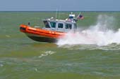
Coastal Defense
Coastal Defense is the protection of the country's coastline, including the Coast Guard and federal, state, or local agencies involved in coastal law enforcement.
CMap
CMap Description
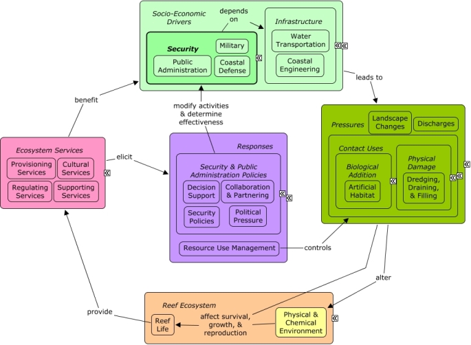
Coastal defense is dependent on large ships that may require dredging of reefs or coastal vegetation to enable transportation into ports. In some areas, such as Vieques, Puerto Rico, Armed Forces training exercises have left discarded ammunition in coastal areas that may provide artificial habitat or discharge contaminants into coastal waters. Security sectors benefit indirectly from ecosystem services that improve the well-being of other sectors, such as culture or fishing, which pressure public administration to enact responses to protect reef ecosystems. Public administrators may improve decision-making through collaboration & partnering, and may improve effectiveness of regulations through law enforcement.Citations
More than 50 citations. Click here to load.
| Citation | Year | Study Location | Study Type | Database Topics |
|---|
Management Options
| Management Option | Description | Sources | Database Topics |
|---|---|---|---|
| Damage Assessment, Documentation & Response: Respond to Natural Resource Injuries form Derelict Vessels | Semi- permanent/permanent vessels can have a negative impact on the surrounding local environment both due to the effects of shade and from the direct contact with the substrate. Sunken vessels that cannot be seen from the surface may present a danger to navigation. Derelict vessels that do not remain stationary may cause harm in multiple locations before becoming stationary. If fishing gear is still intact, it may cause further biological damage through "ghost fishing� (#283). Early response, creating mooring fields, pump-out stations, and providing support for removing derelict vessels, reduces the impact of these vessels. Also, the removal of intrusive vessels will help contribute to the restoration of reef areas to previous conditions. | NOAA Marine Sanctuary Program. 2007. Florida Keys National Marine Sanctuary revised management plan. National Ocean Service, Key West, FL. |
Anchoring & Vessel Grounding; Artificial Habitat; Artisanal Fishing; Biological Monitoring & Restoration; Boat Movement; Boating Activities; Boating Regulations; Coastal Defense; Commercial Fishing Boats; Coral; Ecosystem Monitoring & Restoration; Environmental Monitoring & Restoration; Large Ships; Marine Debris; Military; Physical Damage; Reef Habitat; Reef Life; Resource Use Management; Seagrasses; Small Boats; Stony Coral; Substrate; Transportation Policies; Water Depth & Sea Level; Water Transportation; Wetlands |
| Damage Assessment, Documentation & Response: Collaborate with Towing & Salvage Operators in Grounding Notification | This option advocates the establishment of rapport between local operators and regulatory agencies. This is achieved through regular meetings and training sessions to emphasize the importance of operator cooperation in regards to vessel groundings. | NOAA Marine Sanctuary Program. 2007. Florida Keys National Marine Sanctuary revised management plan. National Ocean Service, Key West, FL. |
Anchoring & Vessel Grounding; Boating Activities; Coastal Defense; Collaboration & Partnering; Commercial Fishing Boats; Cruise Ships; Cultural Policies; Environmental Education & Outreach; Large Ships; Military; Oil & Gas Tankers; Physical Damage; Security & Public Administration Policies; Small Boats; Transportation; Transportation Policies; Water Transportation |
| Marine Zoning: Wildlife Management Areas (WMAs) | Wildlife Management Areas include bird nesting, resting, or feeding areas, turtle nesting beaches, and other sensitive habitats including shallow flats that are important feeding areas for fish. These areas seek to provide protection for endangered/threatened species or their habitats while at the same time providing opportunity for public use. Wildlife Management Areas are achieved through placing and maintaining buoys along zone boundaries; implementing management responsibilities; adjusting existing zone boundaries if needed; evaluating allowable activities within the boundaries and make changes if needed; identifying potential areas that need additional zoning; monitoring the effectiveness of current zones; and revising GIS and NOAA charts. | NOAA Marine Sanctuary Program. 2007. Florida Keys National Marine Sanctuary revised management plan. National Ocean Service, Key West, FL. |
Accidental & Illegal Harvest; Beaches & Nature Parks; Biological Harvest; Biological Monitoring & Restoration; Boating Activities; Coastal Defense; Contact Uses; Cultural Services; Decision Support; Designate Protected Species; Designated Uses; Ecosystem Monitoring & Restoration; Entertainment & Accommodation Services; Environmental Monitoring & Restoration; Fisheries & Hunting Policies; Fishing & Harvesting Management; Fishing Sector; Landscape Conservation & Restoration; Marine Birds; Marine Protected Areas; Permitting & Zoning; Physical Damage; Recreational Fishing; Recreational Opportunities; Resource Use Management; Sea Turtles; Tourism & Recreation; Trampling; Water Transportation; Wetlands |
| Marine Zoning: Sanctuary Preservation Areas (SPAs) | This is a type of Marine Zoning used by the Florida Keys National Marine Sanctuary (FKNMS). SPAs focus on the protection of shallow, heavily used reefs where conflicts occur between user groups, and where concentrated visitor activity leads to resource degradation. They are designed to enhance the reproductive capabilities of renewable resources, protect areas critical for sustaining and protecting important marine species, and reduce user conflicts in high-use areas. This is accomplished through a prohibition of consumptive activities within these areas. They have been chosen based on the status of important habitat, the ability of a particular area to sustain and protect the habitat, the level of visitor use, and the degree of conflict between consumptive and non-consumptive users. The actual size and location of these zones have been determined by examination of user patterns, aerial photography, and ground-truthing of specific habitats. | NOAA Marine Sanctuary Program. 2007. Florida Keys National Marine Sanctuary revised management plan. National Ocean Service, Key West, FL. |
Accidental & Illegal Harvest; Anchoring & Vessel Grounding; Aquaculture; Aquarium & Pet Trade; Aquarium Stock; Artisanal Fishing; Beaches & Nature Parks; Biological Addition; Biological Harvest; Biological Monitoring & Restoration; Boat Movement; Boating Activities; Boating Regulations; Coastal Defense; Coastal Development; Coastal Engineering; Commercial Fisheries; Commercial Fishing Boats; Complex Habitat & Resources; Cruise Ships; Cultural Services; Decision Support; Designated Uses; Dive, Snorkeling, & Swimming Tourism; Dredging Regulations; Dredging, Draining, & Filling; Ecosystem Monitoring & Restoration; Educational & Research Opportunities; Entertainment & Accommodation Services; Environmental Monitoring & Restoration; Finfish & Shellfish Stock; Finfish Harvest; Fisheries & Hunting Policies; Fishing & Harvesting Management; Fishing Sector; Invertebrate Harvest; Landscape Changes; Large Ships; Live Collection; Marine Protected Areas; Oil & Gas Tankers; Ornamental Jewelry & Art; Permitting & Zoning; Physical Damage; Public Administration; Recreational Fishing; Recreational Opportunities; Resource Use Management; Security; Small Boats; Souvenir & Decorative Trade; Supporting Services; Tourism & Recreation; Tourism & Recreation Policies; Trampling; Travel Services & Tour Operators; Trawling & Fishing Gear Damage; Water Resources; Water Transportation |
| Marine Zoning: Existing Management Areas | The Florida Keys National Marine Sanctuary (FKNMS) uses this zoning category to identify areas that are managed by other agencies where restrictions already exist. These zones delineate the existing jurisdictional authority of other agencies (i.e., State parks, aquatic preserves, sanctuaries, and other restricted areas). Management of these areas within the Sanctuary may require additional regulations or restrictions to adequately protect resources. Any additional management measures will be developed and implemented in coordination with the agency having jurisdictional authority. Their function is not to establish another layer of bureaucracy, but to recognize established management areas and, at a minimum, to complement the existing management programs, ensuring cooperation and coordination with other agencies. Existing Management Areas will be maintained through revising GIS and NOAA charts. | NOAA Marine Sanctuary Program. 2007. Florida Keys National Marine Sanctuary revised management plan. National Ocean Service, Key West, FL. |
Accidental & Illegal Harvest; Beaches & Nature Parks; Biological Harvest; Biological Monitoring & Restoration; Boating Activities; Coastal Defense; Contact Uses; Decision Support; Designate Protected Species; Designated Uses; Ecosystem Monitoring & Restoration; Entertainment & Accommodation Services; Environmental Education & Outreach; Environmental Monitoring & Restoration; Fisheries & Hunting Policies; Fishing & Harvesting Management; Marine Protected Areas; Permitting & Zoning; Recreational Fishing; Resource Use Management; Tourism & Recreation; Water Transportation |
| Marine Zoning: Ecological Reserves (ERs) | Ecological Reserves set aside areas with minimal human interference. These reserves aim to enhance and protect biodiversity through encompassing large, contiguous habitats. The goal of ecological reserves is to encourage spawning, nurseries, and residence areas that contribute to genetic protection of fish and marine life. Ecological Reserves can be achieved through a variety of methods such as: placing/maintaining buoys along zone boundaries; adjusting boundaries if necessary; evaluating allowable activities within zone boundaries; identifying potential areas that need additional zoning; reviewing the effectiveness of the zoning; and revising NOAA and GIS charts. | NOAA Marine Sanctuary Program. 2007. Florida Keys National Marine Sanctuary revised management plan. National Ocean Service, Key West, FL. |
Biochemical & Genetic Resources; Biological Addition; Biological Harvest; Biological Monitoring & Restoration; Boating Activities; Boating Regulations; Coastal Defense; Commercial Fishing Boats; Complex Habitat & Resources; Cruise Ships; Decision Support; Designated Uses; Dredging Regulations; Dredging, Draining, & Filling; Ecosystem Monitoring & Restoration; Environmental Monitoring & Restoration; Finfish Harvest; Fisheries & Hunting Policies; Fishing & Harvesting Management; Fishing Sector; Invertebrate Harvest; Large Ships; Live Collection; Marine Protected Areas; Oil & Gas Tankers; Permitting & Zoning; Physical Damage; Provisioning Services; Resource Use Management; Security Policies; Small Boats; Tourism & Recreation; Trampling; Water Transportation |
| Monitor & Research: Monitor Use Patterns on Artificial and Natural Reefs | This management option seeks to provide data for decisions concerning creating new artificial reefs. Use data is important because justification for artificial reefs extends from their ability to shift use pressures (diving, fishing, etc.) from natural reefs. Once an artificial reef is decided on there is much more data to collect and factors to consider when deciding where the artificial reef (#189). | NOAA Marine Sanctuary Program. 2007. Florida Keys National Marine Sanctuary revised management plan. National Ocean Service, Key West, FL. |
Artificial Habitat; Biological Addition; Biological Monitoring & Restoration; Boating Activities; Civil Engineering & Construction; Coastal Defense; Complex Habitat & Resources; Coral; Cultural Services; Decision Support; Dive, Snorkeling, & Swimming Tourism; Ecosystem Monitoring & Restoration; Environmental Monitoring & Restoration; Finfish & Shellfish Stock; Fishing Sector; Military; Museums, Amusement Parks, Historical Sites; Provisioning Services; Recreational Fishing; Recreational Opportunities; Reef Habitat; Reef Life; Security; Security & Public Administration Policies; Supporting Services; Tourism & Recreation; Tourism & Recreation Policies; Transportation; Travel Services & Tour Operators; Valuation; Wetland & Reef Restoration |
| Regulatory Review and Development: Evaluate Artificial Reef Regulations | Discharge/depositing of materials and constructions on the seabed are both prohibited without permits, regulating the construction of new artificial reefs. Likewise, existing artificial reefs are protected through permit requirements for any alternation of the seabed. There are still further considerations for protecting artificial reefs. Artificial reef materials and construction choices are very important and may change based on the specific location and desired impacts. An artificial reef to attract recreational fishing differs from one for recreational divers or shoreline storm protection. Many artificial reefs were formally large ships, oil rigs or other types of waste that have been decommissioned and would be too large and expensive to dismantle on land. In these cases it is important to put restrictions on the sinking process to ensure there won�t be any type of chemical leakage and that the structure is stable on the seabed. (#189) (#190) | National Oceanic and Atmospheric Administration. 2007. National Artificial Reef Plan: Guidelines for Siting, Construction, Development, and Assessment of Artificial Reefs. US Department of Commerce. NOAA Marine Sanctuary Program. 2007. Florida Keys National Marine Sanctuary revised management plan. National Ocean Service, Key West, FL. |
Artificial Habitat; Coastal Defense; Contact Uses; Discharge Limitations; Discharges; Dive, Snorkeling, & Swimming Tourism; Dredging Regulations; Environmental Monitoring & Restoration; Large Ships; Oil & Gas Industry; Permitting & Zoning; Physical Damage; Recreational Fishing; Solid Waste Disposal; Special Use Permitting; Tourism & Recreation; Waste Management; Waterborne Discharges |
Laws
| Legal Citation | Purpose of Law | Management Organization | Database Topics |
|---|---|---|---|
| General permit for activities seaward of the coastal construction control line, 62B-34 Florida Administrative Code Annotated (2010). | To implement the provisions of Section 161.053(19) F. S. providing General Permits for activities performed seaward of the Coastal Construction Control line. Persons wishing to use one or more of the General Permits as set forth in Part II of this rule chapter shall be subject to the notice provisions of subsection 62B-34.030(4) F. A. C. before any activity is conducted as authorized herein.The general conditions provided pursuant to Section 62-B34-0.50, F. A. C. , shall apply to all of the General Permits issued under this rule chapter. Strict compliance with all of the terms, conditions, requirements, limitations, and restrictions applicable to a desired General Permit under this rule chapter is required to qualify for such a permit. Application to Coral Reefs:The rule requires erosion control BMP. Therefore, sediment from construction will not enter the marine environment and damage coral reefs. Legislative Actions:Civil fines are applicable for work done that was not authorized in the permit. Comments: |
Florida Departrment of Environmental Protection Jurisdiction: State Coastal Waters |
Beaches & Nature Parks; Coastal Defense; Coastal Development; Coastal Engineering; Complex Habitat & Resources; Construction Codes & Projects; Docks & Marinas; Dredging, Draining, & Filling; Landscape Conservation & Restoration; Landuse Management; Mangroves; Ports & Harbors; Resource Use Management; Seagrasses; Sediment; Shoreline Armoring |
| Sovereign submerged lands management, 18-21 Florida Administrative Code Annotated (2006). | To manage, protect, and enhance sovereignty lands so that the public may continue to enjoy traditional uses, including, but not limited to, navigation, fishing and swimming, public drinking water supply, shellfish harvesting, public recreation, and fish and wildlife propagation and management. Application to Coral Reefs:Permitting activities on submerged lands owned by Florida will improve water quality which will indirectly protect reef systems. Legislative Actions:These rules are to implement the administration and management responsibilities of the board and department regarding sovereign submerged lands. Responsibility for environmental permitting of activities and water quality protection on sovereign lands is vested with the Department of Environmental Protection. These rules are considered cumulative. Comments: |
Florida Department of Environmental Protection Jurisdiction: State Coastal Waters |
Anchoring & Vessel Grounding; Aquaculture; Beach & Land Formation; Coastal Defense; Commercial Fisheries; Construction Codes & Projects; Docks & Marinas; Dredging Regulations; Dredging, Draining, & Filling; Energy Policy & Development; Existence Value & Sense of Place; Oil & Gas Research & Exploration; Pipelines; Point Source Discharges; Ports & Harbors; Recreational Fishing; Recreational Opportunities; Resource Use Management; Seawater Flow; Sediment; Shoreline Protection; Trawling & Fishing Gear Damage |