Northwest
Oregon Project Abstract
Western United States Landscape Characterization
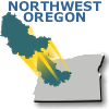
Northwest Oregon Pilot Study Area
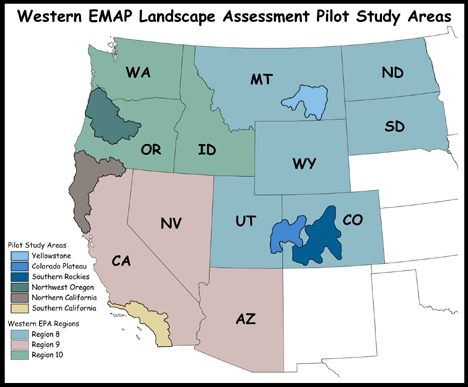
The United States Environmental Protection Agency's Environmental Monitoring and Assessment Program (EMAP) is conducting a pilot study in the western United States. This study will advance the science of ecological monitoring and demonstrate techniques for regional-scale assessment of the condition of aquatic resources in the 14 western states in EPA Regions 8, 9, and 10 (shown below). This browser is a demonstration of a versatile communication device for our landscape ecological assessment products, reports, assessments, data studies, and analysis tools.
Human stresses on the natural resources of the United States are intense. These pressures have resulted in many unintended changes in our ecosystems -- loss of biodiversity, increases in the number of endangered species (e.g. salmon), habitat degradation, and increases in contamination and pollution. Major public and private efforts have gone into controlling pollution, and protecting and restoring natural resources and the ecosystems they depend on. Corrective actions have, and will continue to have, an impact upon how we all lead our lives. We react to the problems that are most visible and thus receive the greatest amount of publicity. To make the most of our environmental efforts, we need to understand and assess the status and trends in the condition of our ecological resources and the stressors affecting these systems. It is not at all clear that we are currently targeting financial resources and/or lifestyle changes on problems or at locations where they will have the most effect.
The landscape component of the Western Pilot Study provides information that has multiple management implications. Regional Landscape products will be provided to assess the spatial distribution of landscape stressors on aquatic ecosystems across each region. This will assist regional managers in understanding how landscape conditions contribute to varying aquatic resource conditions. As such, the products also will contribute to formulation of specific management actions for different geographic locations within each region. The first step in providing regional products will be to test and demonstrate landscape assessment methodologies on sub-regional areas of high importance to each Region. This browser concentrates on the Region 10 Northwest Oregon pilot area.
Northwest Oregon Pilot Study Area
The Western EMAP Northwest Oregon Pilot Study Area (NWOPSA) is a contiguous tract of land located in the northwestern and central mountains and northern coastal areas of the State of Oregon. The NWOPSA encompasses approximately 59,167 km2 (22,845 mi2 ) in land area and is somewhat oval in shape. The study area boundary includes the Pacific Ocean on the west from the vicinity of Arch Cape to Waldport, portions of the Coast Range mountains and the Willamette Valley and the Cascade Range on the southwest, the Columbia Plateau and into the approximate geographic center of the state on the southeast, Oregon's Northern Cascades and the Columbia River Basin near the City of Portland on the northeast, to near the community of Longview along the Columbia River
Three main transportation corridors slice north-to-south through the NWOPSA: US Route 101, hugging the Pacific coastline; Interstate 5, cutting through the center of the study area as it connects Portland to Eugene/Springfield via Salem, the state capital; and US Route 97, traveling through the eastern portion of the study area. Many other smaller federal, state, and county roads weave throughout the study area, many of which connect to one or more of these major routes. The Pacific Crest National Scenic Trail runs between and follows parallel to Interstate 5 and US Route 97, tracing a path through the higher elevations of the Cascade Range. The coastal plain and Coast Range portion of the study area is comprised primarily of a mixture of federal, state, and private lands. In addition, more than two dozen state parks and recreation areas dot the study area coastline. Much of the Cascade Mountains within the study area are managed by the USDA Forest Service, including several wilderness areas; although a portion of the Warm Springs Indian Reservation is within the study area boundary, as well. The intermountain Willamette Valley and lowlands areas are largely privately owned or urban/municipal lands. Much of the private lands in both the coastal and valley areas are generally used for commercial agriculture and timber-related activities. The study area contains in excess of three-quarters of the state's nearly 3.5 million residents, most of whom live in the cities and counties located along or adjacent to Interstate 5. The economy of the area is based mostly on forest products, tourism, and agriculture.
The dominant geographic features within the NWOPSA include the mountains of the Coast Ranges and the Oregon Cascades, both of which lie north-south in orientation; the Willamette Valley, which is situated between these two mountain ranges; and the upper Deschutes River Basin to the east. The elevation ranges from over 3200 m (10,497 ft) at Mount Jefferson to sea level along the coast. The average annual precipitation can span an extremely wide range, from less than 250 mm (10 in.) in the eastern portion of the study area in the Columbia Plateau region to as much as 4600 mm (180 in.) in the temperate rainforests of the coastal mountains in the northwest. In addition to the Columbia River, many smaller, regionally significant tributaries to the Columbia, as well as other watercourses, are found within the study area boundaries. Most prominent are the Willamette River in the center of the study area and the Deschutes River in the east. In addition, many predominantly east-west trending rivers occupy the western portion of the study area, flowing from their sources in the Coast Ranges and emptying directly into the Pacific Ocean. Most of these waterways are critical salmon habitats. Much of the higher-elevation areas within the NWOPSA, some of which is categorized as temperate rain forest, sustain various mixed coniferous tree species such as Douglas fir, hemlock, Ponderosa pine, and spruce. Hardwoods are generally found in riparian areas and along the mountain foothills. Portions of the easternmost extent of the study area also include juniper, sagebrush and chaparral, and sparsely vegetated shrublands and desert environments.
References
Inforain. Map: Northwestern Oregon Major Land Ownership. ![]()
http://www.inforain.org/maparchive/nc_land_own.htm
State of Oregon. Oregon Department of Forestry. ![]()
http://www.odf.state.or.us
State of Oregon. Oregon Geography - NETSTATE. ![]()
http://www.netstate.com/states/geography/or_geography.htm
For More Information Visit
EPA - EMAP Western Pilot StudyWestern Pilot Study, EPA - EMAP Regional Web Sites