|
|
Methodology and Interpretation
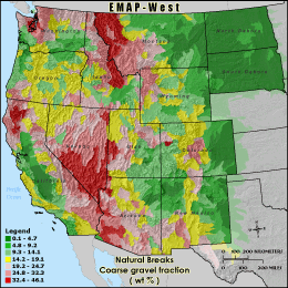
CGRVL - Coarse gravel fraction ( wt % )
STATSGO weighted-average soil coarse gravel
fraction (> 5-mm and < 75-mm diameter) using
approximate EMAP physical habitat substrate criteria,
expressed as percent by weight
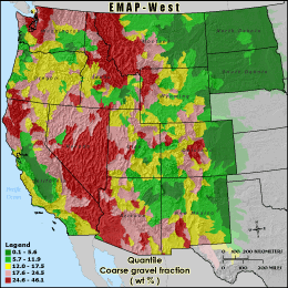
Quantile: Each class contains an approximately equal number (count) of features. A quantile
classification is well-suited to linearly distributed data. Because features are grouped by the number
within each class, the resulting map can be misleading, in that similar features can be separated into
adjacent classes, or features with widely different values can be lumped into the same class. This
distortion can be minimized by increasing the number of classes.
Natural Breaks: Classes are based on natural groupings of data values. Natural break points
are identified by looking for groupings and patterns inherent in the data. The features are divided
into classes whose boundaries are set where there are relatively large jumps in the distribution of
data values.
* EMAP-West Soil / Landform Metrics Metadata (FGDC)
|
|