|
|
Methodology and Interpretation
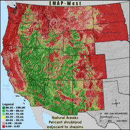
RSHRB0 - Percent shrubland adjacent to streams
The percentage of shrubland land cover adjacent to streams is calculated by
dividing the number of shrubland land cover cells underneath stream segments in the
grid cell reporting unit and dividing by the stream corridor's total land
area (total number cells underneath stream segments minus those classified as
water).
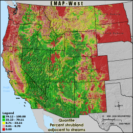
Quantile: Each class contains an approximately equal number (count) of features. A quantile
classification is well-suited to linearly distributed data. Because features are grouped by the number
within each class, the resulting map can be misleading, in that similar features can be separated into
adjacent classes, or features with widely different values can be lumped into the same class. This
distortion can be minimized by increasing the number of classes.
Natural Breaks: Classes are based on natural groupings of data values. Natural break points
are identified by looking for groupings and patterns inherent in the data. The features are divided
into classes whose boundaries are set where there are relatively large jumps in the distribution of
data values.
* EMAP-West Landscape Metrics Metadata (FGDC)
|
|