|
|
Methodology and Interpretation
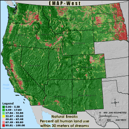
RHUM30 - Percent all human land use within 30 meters of streams
The percentage of human use land cover 30 meters adjacent to streams is
calculated by summing the total number of agricultural, urban and non-natural
barren (transitional and mines/quarries) land cover cells underneath stream
segments in the 3 km grid cell reporting unit and within a one cell buffer
(30 meters) and dividing by the stream corridor's total land area (all cells
30 meters adjacent to streams minus those classified as water). Cells inside
the buffer zone but outside of the grid cell boundary are ignored. This metric
can be used to identify areas near streams which may be more susceptible to
non-point source pollution, pesticides, excess fertilizer and soil erosion which
may result in stream and lake sedimentation or eutrophication.
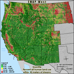
Quantile: Each class contains an approximately equal number (count) of features. A quantile
classification is well-suited to linearly distributed data. Because features are grouped by the number
within each class, the resulting map can be misleading, in that similar features can be separated into
adjacent classes, or features with widely different values can be lumped into the same class. This
distortion can be minimized by increasing the number of classes.
Natural Breaks: Classes are based on natural groupings of data values. Natural break points
are identified by looking for groupings and patterns inherent in the data. The features are divided
into classes whose boundaries are set where there are relatively large jumps in the distribution of
data values.
* EMAP-West Landscape Metrics Metadata (FGDC)
|
|