|
|
Methodology and Interpretation
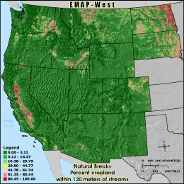
RAGC120 - Percent cropland within 120 meters of streams
The percentage of cropland cover within 120 meters of a stream is calculated
by summing the total number of cropland land cover cells underneath stream
segments in the 3 km grid cell reporting unit and within a three cell buffer
(120 meters) and dividing by the stream corridor's total land area (all cells 120
meters adjacent to streams minus those classified as water). Cells inside the
buffer zone but outside of the grid cell boundary are ignored. Agricultural
practices typically employ fertilizers, pesticides and other chemicals that may
be transported to streams in water runoff. The closer agriculture is to a stream
the more likely related pollutants will enter the stream. Concentrations of
pollutants transported into streams are also more likely to be higher when
agriculture is closer to streams.
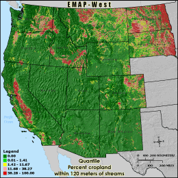
Quantile: Each class contains an approximately equal number (count) of features. A quantile
classification is well-suited to linearly distributed data. Because features are grouped by the number
within each class, the resulting map can be misleading, in that similar features can be separated into
adjacent classes, or features with widely different values can be lumped into the same class. This
distortion can be minimized by increasing the number of classes.
Natural Breaks: Classes are based on natural groupings of data values. Natural break points
are identified by looking for groupings and patterns inherent in the data. The features are divided
into classes whose boundaries are set where there are relatively large jumps in the distribution of
data values.
* EMAP-West Landscape Metrics Metadata (FGDC)
|
|