|
|
Methodology and Interpretation
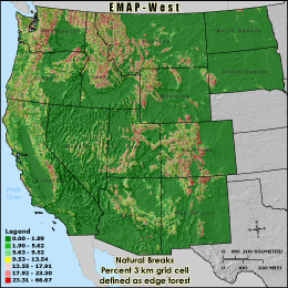
PFEDGE9 - Percent 3 km grid cell defined as edge forest
Percent edge forest is calculated using a moving 270 meter square
window (9 pixels x 9 pixels) across the land cover. When the percent forest in
the window is greater than 60%, but less than the window's PFF9 value,
the forest cell in the center of the window is classified as edge. The number of
edge forest cells in the 3 km grid cell reporting unit is then divided by the
grid cell's total land area (the total number cells in the grid cell boundary
minus those cells classified as water) to derive PFEDGE9. Edge forest indicates
largely continuous, clumped forest which probably provides migration corridors
across an area, but may or may not provide suitable interior habitat, depending
on the species.
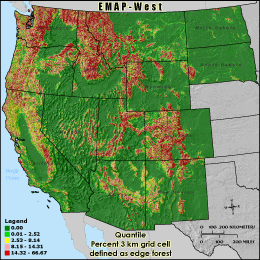
Quantile: Each class contains an approximately equal number (count) of features. A quantile
classification is well-suited to linearly distributed data. Because features are grouped by the number
within each class, the resulting map can be misleading, in that similar features can be separated into
adjacent classes, or features with widely different values can be lumped into the same class. This
distortion can be minimized by increasing the number of classes.
Natural Breaks: Classes are based on natural groupings of data values. Natural break points
are identified by looking for groupings and patterns inherent in the data. The features are divided
into classes whose boundaries are set where there are relatively large jumps in the distribution of
data values.
* EMAP-West Landscape Metrics Metadata (FGDC)
|
|