|
|
Methodology and Interpretation
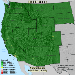
POPDENS - Population density
Population density was calculated by summing number of people living in the
3 km grid cell reporting unit and dividing by the grid cell area. Where census
units were not completely contained within the grid cell, population was apportioned
by area. High population densities are generally well correlated with high amounts
of human land uses, especially urban and residential development. Large areas of
development often involve substantial modification of natural vegetation cover
and may have significant effects on wildlife habitat, soil erosion and water
quality.
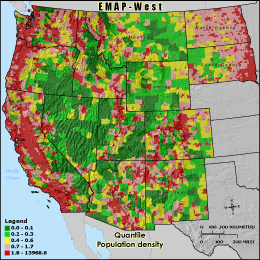
Quantile: Each class contains an approximately equal number (count) of features. A quantile
classification is well-suited to linearly distributed data. Because features are grouped by the number
within each class, the resulting map can be misleading, in that similar features can be separated into
adjacent classes, or features with widely different values can be lumped into the same class. This
distortion can be minimized by increasing the number of classes.
Natural Breaks: Classes are based on natural groupings of data values. Natural break points
are identified by looking for groupings and patterns inherent in the data. The features are divided
into classes whose boundaries are set where there are relatively large jumps in the distribution of
data values.
* EMAP-West Landscape Metrics Metadata (FGDC)
|
|