|
|
Methodology and Interpretation
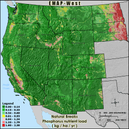
P_LOAD - Phosphorus loading ( kg / ha / yr )
The phosphorus nutrient load is calculated by multiplying a contribution
factor by the the area of certain land cover types known to produce phosphorus.
Default contribution factors are based on literature (Reckhow et al. 1980),
but may be changed by the user.
Reckhow, K.H., Beaulac, M. N., and Simpson, J. T. (1980). Modeling
Phosphorus Loading and Lake Response Under Uncertainty: A Manual and
Compilation of Export Coefficients. USEPA 440/5-80-011. Washington, DC:
Office of Water Regulations and Standards, U.S. Environmental Protection
Agency.
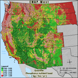
Quantile: Each class contains an approximately equal number (count) of features. A quantile
classification is well-suited to linearly distributed data. Because features are grouped by the number
within each class, the resulting map can be misleading, in that similar features can be separated into
adjacent classes, or features with widely different values can be lumped into the same class. This
distortion can be minimized by increasing the number of classes.
Natural Breaks: Classes are based on natural groupings of data values. Natural break points
are identified by looking for groupings and patterns inherent in the data. The features are divided
into classes whose boundaries are set where there are relatively large jumps in the distribution of
data values.
* EMAP-West Landscape Metrics Metadata (FGDC)
|
|