EMAP-West Overview Presentation
Presentation Links
- What is EMAP - West?
- Purposes
- Objectives
- Specific Assessments
- Scope
- Value of Improved Approaches to Monitoring
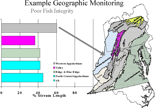
- Geographic Monitoring Example - Poor Fish Integrity
- Key Elements
- Survey Design Characteristics
- Lessons from Mid Atlantic Pilot
- Using EMAP Tools
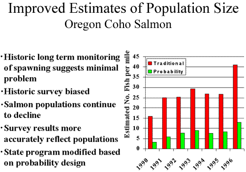
- Improved Estimates of Population Size - Oregon Coho Salmon
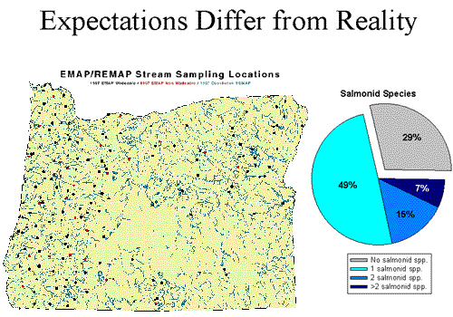
- Expectations Differ from Reality
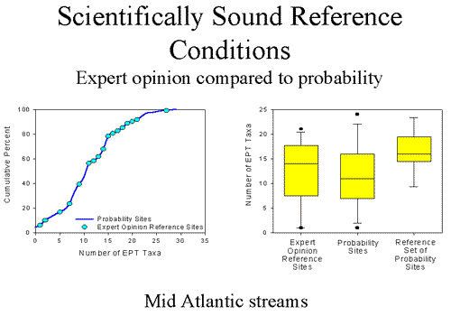
- Scientifically Sound Reference Conditions - Expert opinion compared to probability
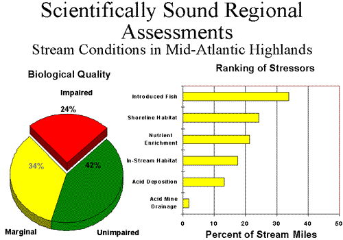
- Scientifically Sound Regional Assessments - Stream Conditions in Mid-Atlantic Highlands
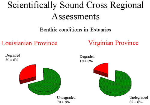
- Scientifically Sound Cross Regional Assesments - Benthic conditions in Estuaries
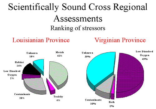
- Scientifically Sound Cross Regional Assessments - Ranking of stressors
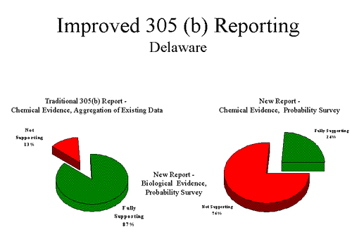
- Improved 305(b) Reporting - Delaware
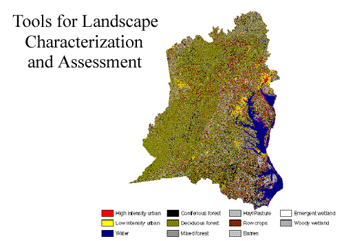
- Tools for Landscape Characterization and Assessment
- A monitoring demonstration of indicators and designs for measuring environmental progress
- unbiased estimates of condition of ecological resources
- comparative ranking of stressors
- tools for biocriteria
- partnerships between EPA/States/Tribes
- Demonstrate the value of survey based monitoring
- apply to real problems of Regional/State interest
- Advance the science of monitoring
- indicators
- designs
- reference conditions
- assessment methods
- Estimate condition of ecological resources
- estuaries
- rivers and streams
- landscapes
- Identify likely stressors to these systems
- Build State capacity for long-term monitoring
- monitoring tools
- analytical capability
- partnerships
- Coastal
- conditions of estuaries by state
- intensive studies - one for each State
- Surface Waters
- conditions of rivers and streams by State
- intensive studies - one for each Region
- Landscapes
- land cover atlas for the West
- quantification of relationship between landscape indicators and aquatic condition
- Area
- EPA Regions 8,9, and 10
- States of North Dakota, South Dakota, Montana, Wyoming, Colorado, Utah, Arizona, Nevada, California, Oregon, Idaho and Washington
- EPA Regions 8,9, and 10
- Resources
- Coastal waters
- Surface waters
- Landscapes
Value of Improved Approaches to Monitoring
- Monitoring for results
- GPRA Objectives
- Targeting
- most important areas
- most important stressors
- Support development of biocriteria
- Support for specific assessments
- 305 (b) reporting
- Ecological (i.e., biological) resources
- Direct measures of condition
- "Integrated" condition
- Reference conditions
- Surveys for unbiased results
- Ranking of stressors
- Spatial comparisons
- Guarantees representation and inference to systems of interest
- Adapted to resource characteristics
- Adjusts sample sizes to meet precision requirements
- Adaptable to temporal and spatial scales of resolution
Lessons from Mid Atlantic Pilot
- True ORD/Regional partnerships necessary
- Internal Regional and ORD commitment top to bottom (long-term)
- Biological and habitat indicators compliment current chemical monitoring, can be used now and are economical
- Sound environmental characterization can drive management decisions and influence public perceptions
- Statistical surveys are very important to setting goals and measuring progress
- Expanding use of environmental indicators and statistical surveys changed the view of relative risk
- Long term outlook essential
- Partnership/stakeholders involvement is critical
- Improved estimates of population size
- Expectations differ from reality
- Scientifically sound reference conditions
- Scientifically sound regional assessments
- Scientifically sound cross regional assessments
- Improved 305 (b) reporting
- Tools for landscape characterization and assessments
![[logo] US EPA](../gif/logo_epaseal.gif)
