| Great Lakes Ecosystems | ||
|
||||||||||
|
1994
Proceedings
| |||||||||||||||||||||||||||||||||||||||||||||||||||||||||||||||
|
RELATIONSHIPS BETWEEN GRASS AND COMPOSITE DENSITIES
AND WOODY PLANT STRUCTURE IN NORTHEASTERN ILLINOIS
Charles A. Ruedebusch, Graduate Student |
 |
Community classification can be based on the species present in an area, on the abundance of species, or on the structure of the vegetation. Because structure tells much about how the vital resource of light is utilized, methods such as the UNESCO formation classification system place structure at a higher level than species presence (Barbour et al. 1987). Forests, woodlands, savannas, and grasslands are viewed as a progression from little light reaching a person's head to almost all light reaching that level. This structure is usually defined by percent cover by trees. However, operational definitions of cover are difficult to apply and we have chosen to measure structure with estimates of the density of members of various vegetation classes and/or the basal area of woody vegetation at breast height.
Typically, savannas are distinguished from woodlands and forests by being dominated by graminoid vegetation rather than trees. Implicit in this statement is the suggestion that graminoid vegetation is rare in forests. We sought to explore the relationship between the density and basal area of trees and the density of grasses and composites in five preserved areas of northeastern Illinois. We found a strong negative relationship between the basal area and the density of both grasses and composites.
We wrote to a number of individuals requesting their opinions concerning the best representatives of savannas in northeastern Illinois. The Iroquois County Conservation area and its neighboring Hooper Branch Savanna, and the Middlefork Savanna in Lake County received the greatest number of recommendations. G.A.R. Woods in western Cook County was chosen as a floodplain forest along the Des Plaines River. Both McClaughry Springs Woods and Tinley Creek Woods are in southwest Cook County on the Valparaiso moraine. The latter two sites have large oaks (which have been suggested to identify savanna) and were being studied for possible inclusion in the Illinois Nature Preserve system.
Measurements were taken in September or October 1992 by students in a graduate seminar. The initial positions were 50 m or more from the nearest road. The elevation change within the transect was greatest at Tinley, followed by Hooper, Middlefork, McClaughry, and least at G.A.R.
We studied six classes of vegetation: Trees > 25 cm diameter at breast height (DBH), trees 10 to 25 cm DBH, trees 2.5 to 10 cm DBH, woody vegetation < 2.5 cm DBH (including woody vines), grasses (Family Poaceae), and composites (Family Asteraceae). There were three or four stations studied along a linear transect in each study area. At each station we measured the distance to the nearest member of each vegetation class in each of four quadrants. If no member of the class was found within 15m of our point we stopped searching (except in some cases with the large trees). From the distances measured we estimated the density of each of the vegetation classes following Cottam and Curtis (1956). The mean distance squared equals the mean area per individual of the class. The density of stems per hectare then equals 10,000 times the reciprocal of the mean area. The basal area per hectare was estimated by calculating the mean basal area [pi x (DBH/2)2] for each of tree classes, and multiplying that mean by the density for that size class, and finally summing over all three size classes.
We encountered a community discontinuity (a 60 m marsh) along the transect at Middlefork. One station fell at the woodland/marsh border, and the other station was set at the border on the other side. The two quadrants away from the marsh at each of these points were combined into a single station.
Basal area per hectare measurements ranged from 8.3 m2/ha at Middlefork to 44.8 m2/ha at McClaughry Springs (Table 1). The density of trees > 25 cm DBH ranged from 29 stems/ha at Middlefork to 176 stems/ha at G.A.R. Both measurements gave a similar picture of the comparable tree structure at the five sites. We found that the trees > 25 cm DBH comprised the great majority of BA/ha at the five sites: Tinley 68.0%, Middlefork 68.5%, Hooper 80.2%, G.A.R. 84.3%, and McClaughry 84.5%.
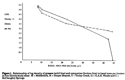
Figure 1 shows the clear negative relationship between BA/ha and grass and composite density at the five sites. On a log transformed basis, densities decline in a nearly linear pattern as basal area increases over the five sites. Grass densities ranged substantially over the five sites, from 2.5 x 10⁵ stems/ha at Middlefork to 98 stems/ha at G.A.R. Composites ranged similarly form 2.1 x 10⁵ stems/ha at Middlefork to none found at McClaughry. The density of woody plants < 2.5 cm DBH showed no relationship to overall BA/ha (Table 1). The greatest densities of small wood plants were seen at Middlefork and McClaughry, the sites with the lowest and highest basal area measurements, respectively.
Both the density (stems/ha) of trees > 25 cm DBH and the overall basal area measurements separated the two savanna sites (Hooper Branch and Middlefork) from the other three sites (Table 1). The two savanna sites also had much greater densities of both grasses and composites (Fig. 1). This is consistent with the idea that savannas are distinguished by a transition from dominance by trees to that of grasses. Composites, chosen because they typically are abundant in more open landscapes in these months, also show a strong inverse relationship between their abundance and the basal area of the site. Interestingly, there seems to be no relationship between basal area and the density of small woody vegetation (Table 1).
The shade associated with basal areas of over 20 m2/ha is the most likely explanation of the reduced density of grasses and composites. The high density of small woody vegetation in some areas with high basal area suggests, however, that other factors may also be involved. That factor is likely to be fire, which would kill some proportion of the small woody vegetation. The reduction of density of small woodies is likely to allow light and water to be diverted to grasses and composites even when the basal area remains high.
The point quarter method allows one to estimate the density of any vegetation class one cares to define. Dividing the > 10 cm DBH trees at the 25 cm point effectively separates canopy trees from subcanopy trees in northeastern Illinois. The two smallest classes pick up species that never reach the canopy as well as those that do. Density of individuals in various size classes gives a very complete picture of the vegetation. We find that basal area serves as a very useful and operationally definable descriptor of stem density and therefore community classification.
We would like to thank Cathryn Bulicek, Marian Kadushin, Jane Norman, and Bill Sluis for assistance in data collection.
Barbour, M. G., J. H. Burk, and W. D. Pitts. 1987. Terrestrial Plant Ecology. 2nd Ed. Benjamin Cummings, Menlo Park CA.
Cottam, G. and J. T. Curtis. 1956. The Use of Distance Measures in Phytological Sampling. Ecology 37 (3): 451-460.
Table 1. Basal area per hectare, size class density and most frequent species at five Illinois study sites.
| Site Name |
Basal
area (m2/ha) |
Density (stems/ha) |
Most Frequent Species in Class |
||||
| Trees >25cm dbh |
Woodies <2.5cm dbh |
Woody
>25cm dbh |
Woody
2.5-10cm dbh |
Grass | Composite | ||
| Middlefork Savanna | 8.3 | 29 | 153,415 | Quercus velutina | Rhamnus cathartica (b) | Calamagrostis canadensis | Aster praealtus |
| Hooper Branch Savanna | 10.6 | 61 | 10,807 | Quercus velutina | Quercus velutina | Panicum oligosanthes | Erigeron canadensis |
| Tinley Creek Woods | 22.1 | 127 | 36,918 | Tilia americana (a) |
Acer saccharinum (c) |
Leersia virginica | Solidago flexicaulis |
| G.A.R. Woods bottomland | 41.2 | 176 | 1,519 | Celtis occidentalis | Fraxinus pennsylvanica (d) |
Elymus virginicus | Aster lateriflorus |
| McClaughry Springs Woods | 44.8 | 155 | 158,482 | Quercus alba | Prunus serotina |
NONE |
Soltdago flexicaulis |
![]()
![]()
![]()