 |
|
Great Lakes Coastal Wetlands: Abiotic and Floristic
Characterization
Plate
4. Wetland Site Types of Riverine and Estuarine Systems
Deltas form when stream sediments are deposited and accumulate at the
mouth of a river creating multiple shallow channels, low islands, and
abandoned meanders that can allow for extensive wetland development. Wetland
habitats within the delta range from the generally sandy or gravel
substrates and swift current of the main channel, to the more protected
secondary channels, where the slow to non-existent current permits thick
accumulations of organics. Delta formation is best developed in areas of low
gradient flow, where nearshore currents are relatively weak and thus do not
rapidly remove deposited material.
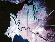 Plate 4a. Delta of the Sturgeon River in Portage Lake, Upper
Peninsula, MI. The Sturgeon River drops its sediment load as it enters
Portage Lake, creating a well-developed delta. Several old meanders and
oxbow ponds are clearly visible within the delta. (1978 color infra-red
photography, Michigan Department of Natural Resources). Plate 4a. Delta of the Sturgeon River in Portage Lake, Upper
Peninsula, MI. The Sturgeon River drops its sediment load as it enters
Portage Lake, creating a well-developed delta. Several old meanders and
oxbow ponds are clearly visible within the delta. (1978 color infra-red
photography, Michigan Department of Natural Resources).
Lacustrine or freshwater estuaries, formed where some tributary
rivers enter the lakes, represent a zone of transition from stream to lake
within which water level, sedimentation, erosion, and biological processes
are controlled by fluctuations in lake level. Most Great Lakes estuaries
were formed as buried river mouths, when stream channels cut during an
earlier time were drowned or buried by the subsequent rise in the Great
Lakes to present water levels. Fairly steep upland slopes help shield the
estuary, while reduced water velocities lead to deep accumulations of
organics; the result is a protected, fertile (but topographically
circumscribed) wetland. Longshore transport and infilling may modify the
submerged river mouth, leading to distinct estuarine forms with different
wetland characteristics.
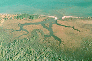 Plate 4b. Open Estuary at Sand River, Bayfield County, WI.
Estuaries that are open to the lake typically display a branching inlet
pattern that clearly reveals their origin as a drowned river mouth. Sand
bars have formed at the mouth of this estuary, but do not appear to
seriously impede water flow. (Photo by Eric Epstein, 1996). Plate 4b. Open Estuary at Sand River, Bayfield County, WI.
Estuaries that are open to the lake typically display a branching inlet
pattern that clearly reveals their origin as a drowned river mouth. Sand
bars have formed at the mouth of this estuary, but do not appear to
seriously impede water flow. (Photo by Eric Epstein, 1996).
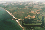 Plate 4c. Barred Estuary at Salmon River, NY. Longshore
transport has nearly barred this estuary by depositing a barrier dune
across its mouth, slowing river discharge into Lake Ontario and forcing
the river to meander broadly. The opening at the river mouth is now
maintained by jetties. (Photo by John Griebsch 1990). Plate 4c. Barred Estuary at Salmon River, NY. Longshore
transport has nearly barred this estuary by depositing a barrier dune
across its mouth, slowing river discharge into Lake Ontario and forcing
the river to meander broadly. The opening at the river mouth is now
maintained by jetties. (Photo by John Griebsch 1990).
|