 |
|
Great Lakes Coastal Wetlands: Abiotic and Floristic
Characterization
Plate 3. Wetland Site
Types Created by Sand-Transport Features (concluded)
 Plate 3a. Sand-Spit Embayment at Little Tail Point, Green Bay, WI.
Formed by longshore transport, the sand spit creates and protects a narrow,
shallow embayment on its landward side. On their lakeward side, such spits
are exposed to wave activity and overwash; on their landward side, however,
the spits generally provide good protection from wind and waves, allowing
organic and fine mineral sediment accumulation and wetland development in
the sheltered embayments. Large, recurved and compound sand spits may also
enclose swales or lagoons which offer protected habitat for emergent
vegetation. (Color infra-red photography, U.S. Army Corps of Engineers). Plate 3a. Sand-Spit Embayment at Little Tail Point, Green Bay, WI.
Formed by longshore transport, the sand spit creates and protects a narrow,
shallow embayment on its landward side. On their lakeward side, such spits
are exposed to wave activity and overwash; on their landward side, however,
the spits generally provide good protection from wind and waves, allowing
organic and fine mineral sediment accumulation and wetland development in
the sheltered embayments. Large, recurved and compound sand spits may also
enclose swales or lagoons which offer protected habitat for emergent
vegetation. (Color infra-red photography, U.S. Army Corps of Engineers).
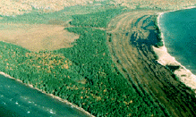 Plate 3b. Dune and Swale Complex at Stockton Island, Ashland County,
Apostle Islands, WI. Alternating upland and wetland features formed as
receding Great Lakes deposited a series of low sandy dunes or beach ridges
(0.5 - 4 m high). From the air, these ridges appear as a series of arcs,
generally parallel to the present shoreline. The flow of surface and ground
water through these complexes can foster wetland development in the swales
between beach ridges; water levels in lakeside swales are directly tied to
Great Lakes water level fluctuations, while those further inland are not.
Swales adjacent to the lake may contain open water and/or herbaceous
wetlands; swales further inland, above the level of Great Lakes influence,
more often support swamp forest or shrub swamp, although open water and
herbaceous wetlands also occur. (Photo by Eric Epstein, 1996). Plate 3b. Dune and Swale Complex at Stockton Island, Ashland County,
Apostle Islands, WI. Alternating upland and wetland features formed as
receding Great Lakes deposited a series of low sandy dunes or beach ridges
(0.5 - 4 m high). From the air, these ridges appear as a series of arcs,
generally parallel to the present shoreline. The flow of surface and ground
water through these complexes can foster wetland development in the swales
between beach ridges; water levels in lakeside swales are directly tied to
Great Lakes water level fluctuations, while those further inland are not.
Swales adjacent to the lake may contain open water and/or herbaceous
wetlands; swales further inland, above the level of Great Lakes influence,
more often support swamp forest or shrub swamp, although open water and
herbaceous wetlands also occur. (Photo by Eric Epstein, 1996).
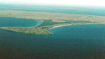 Plate 3c. Tombolo at Stockton Island, Ashland County, Apostle Islands,
WI. Tombolos are islands connected to the mainland by current-deposited
sands, which frequently form a series of parallel beach ridges. The bars or
ridges may enclose a series of shallow interdunal swales, or larger lagoons
within which thick organic soils and a dense growth of aquatic vegetation
develop. The embayment created on the leeward side of the tombolo may
receive sufficient protection from wave action that a fringe of emergent and
submergent vegetation persists. (Photo by Eric Epstein, 1996). Plate 3c. Tombolo at Stockton Island, Ashland County, Apostle Islands,
WI. Tombolos are islands connected to the mainland by current-deposited
sands, which frequently form a series of parallel beach ridges. The bars or
ridges may enclose a series of shallow interdunal swales, or larger lagoons
within which thick organic soils and a dense growth of aquatic vegetation
develop. The embayment created on the leeward side of the tombolo may
receive sufficient protection from wave action that a fringe of emergent and
submergent vegetation persists. (Photo by Eric Epstein, 1996).
|