 |
|
Great Lakes Coastal Wetlands: Abiotic and Floristic
Characterization
Plate 1. Wetland Site
Types of the Great Lakes Shoreline
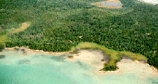 Plate 1a. Open Embayment at Search Bay, Northern Lake Huron.
Curving sections of shoreline open to the lake typically provide minimal
protection for coastal wetland development. Wetlands may establish in areas
where shallow water depth and gently sloping bottom topography reduce wave
height and energy, or in areas where nearshore bars and small sand spits
block the waves, as at Search Bay. Even in more protected portions of the
embayment, shifting sandy sediments can limit emergent wetlands to a narrow
fringe; in contrast, fine-textured (clayey) substrates are ideal for aquatic
macrophyte establishment and persistence, resulting in a continuous ring of
emergent marsh. (Photo by Ted Cline, 1996). Plate 1a. Open Embayment at Search Bay, Northern Lake Huron.
Curving sections of shoreline open to the lake typically provide minimal
protection for coastal wetland development. Wetlands may establish in areas
where shallow water depth and gently sloping bottom topography reduce wave
height and energy, or in areas where nearshore bars and small sand spits
block the waves, as at Search Bay. Even in more protected portions of the
embayment, shifting sandy sediments can limit emergent wetlands to a narrow
fringe; in contrast, fine-textured (clayey) substrates are ideal for aquatic
macrophyte establishment and persistence, resulting in a continuous ring of
emergent marsh. (Photo by Ted Cline, 1996).
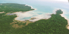 Plate 1b. Open Embayment at Voight Bay, Marquette Island, Northern
Lake Huron. Oriented toward the south, this bay is exposed to wave
energies that develop across the full length of Lake Huron. Exposure to
storm waves limits the development of emergent marsh and submergent marsh
vegetation. Here, the rhizomes of hardstem bulrush attest to a narrow zone
of emergent marsh that was destroyed by high water levels (1985-1986);
recovery of this marsh has been very slow. A fringe of herbaceous vegetation
rims the marly shoreline. (Photo by Ted Cline, 1996). Plate 1b. Open Embayment at Voight Bay, Marquette Island, Northern
Lake Huron. Oriented toward the south, this bay is exposed to wave
energies that develop across the full length of Lake Huron. Exposure to
storm waves limits the development of emergent marsh and submergent marsh
vegetation. Here, the rhizomes of hardstem bulrush attest to a narrow zone
of emergent marsh that was destroyed by high water levels (1985-1986);
recovery of this marsh has been very slow. A fringe of herbaceous vegetation
rims the marly shoreline. (Photo by Ted Cline, 1996).
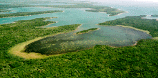 Plate 1c. Protected Embayment at Duck Bay, Marquette Island, Northern
Lake Huron. Indentations or embayments cut into resistant materials of
the upland shoreline provide protection from wind and wave energy; tributary
streams may flow into the basin, and organic and mineral sediments derived
from adjacent uplands may accumulate, allowing development of diverse
wetlands. Glacial deposition and subsequent modification of till created the
protected embayments along the complex shoreline of the Les Cheneaux
Islands, which are drumlinized ground-moraine features. (Photo by Ted Cline,
1996). Plate 1c. Protected Embayment at Duck Bay, Marquette Island, Northern
Lake Huron. Indentations or embayments cut into resistant materials of
the upland shoreline provide protection from wind and wave energy; tributary
streams may flow into the basin, and organic and mineral sediments derived
from adjacent uplands may accumulate, allowing development of diverse
wetlands. Glacial deposition and subsequent modification of till created the
protected embayments along the complex shoreline of the Les Cheneaux
Islands, which are drumlinized ground-moraine features. (Photo by Ted Cline,
1996).
|