| Great Lakes Ecosystems | ||
|
||||||||||
|
1994
Proceedings
|
EXTENT AND STATUS OF MIDWEST OAK SAVANNA: PRESETTLEMENT AND 19851Victoria A. Nuzzo |
 |
Oak savanna covered some 11,000,000 to 13,000,000 hectares of the Midwest at the time of settlement, extending over portions of Minnesota, Iowa, Missouri, Illinois, Wisconsin, Michigan, Indiana and Ohio. Definitions for the community vary between the states, due in part to different concepts of the presettlement appearance and structure of the community, a general lack of phytosociological data about oak savanna, and difficulty in interpreting historical data. Community definitions, a map of the real or potential distribution of presettlement oak savanna2, and description and location of high quality savanna remnants, are presented for each state. In 1985, 113 sites totaling more than 2,607 hectares of relatively high-quality oak savanna were located in the Midwest, approximately 0.02 percent of the presettlement extent of the community.
The term savanna embraces a variety of related plant communities with world-wide distribution, occurring across the temperate and tropical regions, usually in association with grasslands (Eyre 1963, James and Kline 1949, Van Riper 1962). This community is generally defined as consisting of open-grown trees, growing as scattered individuals or in small groves, with an herbaceous, primarily grassy understory (Bray 1955). Bray emphasized that the community is neither a degraded forest nor an ecotone between taiga and tundra, as the two conditions necessary to meet the general definition for savanna (open-grown trees and grassy understory) do not occur in these situations.
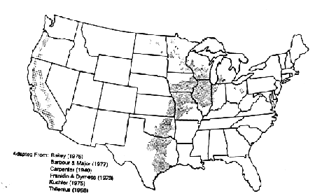
Oak savanna is wide-spread in North America. A number of vegetation maps indicate the range of oak savanna throughout the United States (Bailey 1976; Carpenter 1940; Kuchler 1975; Lindsay 1953; Shreve 1917; Transeau 1935). Great variation in the extent of oak savanna occurs between the maps for similar areas.
In general, oak savanna is distributed along the west coast and through the central portion of the United States. In both regions, savanna is essentially (not always) a transitional community located between areas of forest and grassland. In California and Oregon this is frequently a vertical transition, with savanna occurring from sea level to 900 meters, between valley grassland and mountain forests (Griffin 1977; Kagan 1983; Kuchler 1977; Thilenius 1968). In the central part of the country the transition zone occurs between western prairie and eastern deciduous forest (Anderson 1983; Carpenter 1940; Daubenmire 1978; Dyksterhuis 1957; Kuchler 1975; Vankat 1979).
________________________________________
1 Originally published 1985 in The
Natural Areas Journal 6:6-36. Reprinted with permission of The Natural Areas Journal.
2 Maps and tables are not reprinted.
Midwest savanna is considered here to occur in the northern half of the central United States, a region encompassing Minnesota, Iowa, Missouri, Wisconsin, Illinois, Michigan, Indiana and Ohio. This paper reviews presettlement (prior to 1840) distribution of oak savanna in the Midwest and occurrences of high-quality or pristine remnants as of 1985. This paper presents published and unpublished information provided by individuals, agencies, and organizations within each state. As a result, there is a noticeable variation between the states in terms of definitions, classifications, and quality ranking systems.
Many definitions of Midwest oak savanna have been proposed, based on varying concepts of the community's presettlement distribution and composition. In the eastern prairie-forest transition zone, the presence of prairie, forest, or savanna communities was determined by local environmental factors, including fire, climate, topography and soil (Anderson 1983). Other factors may have included a relationship between savanna and "coarse" soil types (Whitford 1970) and frequent droughts (Drew 1973), and possibly browsing or grazing by large herbivores. Letters and journals of early settlers and explorers differentiated between prairie, barrens, and oak openings on the basis of physical appearance, the response of the communities to fire, and their geographical locations (Williams 1981).
No single definition of Midwest oak savanna is universally accepted, and a multitude of terms have been applied including oak savanna, oak opening, oak barrens, scrub prairie, brush prairie, and brush savanna. In some states, most or all of these terms are used to indicate different aspects of a variable community. In other states, each is considered to be a separate community, or to be part of a forest or a prairie community.
Factors that contribute to the lack of a unifying savanna include: 1) the variable physiognomy of the savanna community; 2) the transitional nature of oak savanna; 3) the difficulty in interpreting historical information; and 4) the general lack of phytosociological information concerning oak savanna.
Variable appearance. There appear to be two basic concepts of savanna appearance: open savanna and scrub savanna. Open savanna is a park-like community with widely-spaced trees, an herbaceous groundlayer, and virtually no shrub layer (Curtis 1959; Dyksterhuis 1957; Stout 1944). Scrub savanna is composed of moderate to dense thickets of oak sprouts within a prairie matrix, with a few fairly dwarfed open-grown trees (Bray 1955; Grimm 1981, 1984). The appearance of scrub savanna varies through both time and space, particularly as influenced by fire (Anderson 1983; Bray 1955; Curtis 1959; Grimm 1981, 1984). The same site, over a period of years, may resemble a brush prairie (grasses hiding the oak sprouts), a brush savanna (woody sprouts taller than the prairie grasses and forbs), or open savanna (a few large trees and the majority of sprouts shorter than the associated prairie vegetation).
Origins. Bray (1955), in a phytosociological study of Wisconsin savannas, attributed the difference between open and scrub savanna to their origins. He hypothesized that open savannas, usually dominated by bur oak (Quercus macrocarpa), evolved on sites where the original deciduous forests contained few or no sprout-forming oak species. These mesic forests were located primarily on rolling and well-drained flatlands. Following fire degradation of these forests during the second Xerothermic period, circa 400 to 1000 A.D., prairie invaded from adjacent areas and, simultaneously or subsequently, bur oak invaded the prairie. The grub-forming ability of bur oak permitted the production of numerous sprouts, which occasionally developed into mature fire-resistant trees. The findings of Cottam (1949), Daubenmire (1978) and Gleason (1923) lend support to this hypothesis. A similar appearing savanna evolved when bur oak invaded sites that were historically dry prairie rather than forest. This process is currently being observed in Iowa along the Missouri River bluffs (Schennum 1984 pers. comm.).
Scrub savanna also evolved during the second Xerothermic period, but on sites with oak species capable of resprouting, particularly Quercus velutina, Q. ellipsoidalis, and Q. alba. These forests developed primarily on hillsides and in areas of abrupt topography, where soil and light conditions hindered development of more mesic forests. The numerous grubs and stump sprouts from the fire-killed oaks formed a permanent brushland within the prairie matrix, with occasional trees attaining adult size.
In contrast to Bray's time frame for establishment of savanna in Wisconsin, around 400 to 1,000 A.D., Grimm (1981, 1983) presented evidence that in Minnesota oak savanna had existed as a community type since approximately 3000 to 400 B.C.
Support for Bray's theory concerning the occurrence of open and scrub savannas on different topographies can be found on many large-scale presettlement vegetation maps. Open savannas (generally dominated by bur oak) are usually depicted on the flatter, frequently mesic areas, and scrub savannas (usually characterized by white oak, black oak and hill's oak) are generally located on the dry to dry-mesic areas of steeper topography, particularly hillsides, dunes, and ridges (AuClair 1976; Bebb 1860; Bray 1955; Curtis 1959; Ewing 1924; Liegel 1982; Nee 1969; Pepoon 1911; Sears 1926; Stout 1944; Tans 1976).
Influence of fire. Fire significantly influenced the development and appearance of both open and scrub savannas, but did not eliminate the oaks (Curtis 1959; Grimm 1984; Irving 1981). Depending on fire intensity and frequency, scrub savanna presented the appearance of prairie, brush prairie, brush savanna, or open savanna. Curtis (1959) described brush prairie remnants in southern Wisconsin, which were burned annually for more than 100 years with no observed reduction in the number of oak grubs present. Henderson (1982) documented that fire frequency influenced the appearance and structure of a Quercus velutina savanna in Indiana; frequent fires were usually of low intensity, rarely killed the overstory trees, and maintained an open understory, while infrequent fires were of high intensity, killed the large trees and stimulated dense sprouting, thus promoting the appearance of a thicket rather than an open savanna. Grimm (1981) pointed out that the number of oak sprouts from oak grubs generally increased with more frequent burning, creating denser thickets.
Numerous historical references have been made to the rapid conversion of savanna to oak forest following the cessation of prairie fires. Twenty to 40 years after settlement, both open and scrub savanna appeared as closed oak forests, a fact attributed to the presence of numerous grubs and sprouts in the originally open-appearing savannas (Bourne 1820 (cited in Grimm 1981); Cottam 1949; Curtis 1959; Grimm 1981; Muir 1913; Schroeder 1981; Stout 1944; Trewartha 1940).
Savanna is a transitional community between oak forest and prairie, usually arbitrarily separated from these communities by canopy cover and species composition.
Canopy Cover. Tree density is the major variable used to distinguish savanna from prairie and forest communities. In Wisconsin, savanna is considered to occur where there is more than one tree per acre (2.5 trees per hectare) and less than 50 per cent canopy (Curtis 1959), while in Missouri canopy levels of 10 per cent to 50 per cent are accepted (Nelson 1985). In other states canopies of 10 to 80 percent are accepted as representing savannas (Wendt 1983, White and Madany 1978), while in Ohio a stand with nearly 100 percent cover maybe considered a savanna (Anderson 1982). Above these cut-off points a stand is considered to be forest; below them the stand is regarded as prairie. However, other plant communities are included within this broad range, and canopy cover alone is insufficient to separate savanna from prairie or forest.
Species Composition. The understory vegetation of savanna is a mixture of both prairie and woodland species, with prairie forbs and grasses more abundant in areas of high light, and forest forbs and woody species in areas of low light (Bray 1958, 1960). In Wisconsin, oak savanna has a similarity index of 0.50 to 0.58 with prairie, and 0.53 with dry oak forest (Curtis 1959). In general, the savanna understory contains less grass and more forbs and shrubs than a prairie, but more grass and fewer forbs, vines, and shrubs than an oak forest (Bray 1960, Curtis 1959). No species is known to be endemic to oak savannas, and relatively few species are modal. In Wisconsin, only six species are considered modal in oak savanna: Heliopsis helianthoides, Besseya bullii, Orobanche uniflora, Phlox glabberima, Ranunculus fascicularis, and Zygadenus elegans (Curtis 1959). An additional four species, Symphoricarpus occidentalis, Convolvulus americanus, Ceanothus americanus and Tephrosia virginiana are "almost limited in amplitude to savanna" (Bray 1960). Packard (in press) suggests that oak savanna has a distinct herbaceous community characterized by species adapted to frequent large-scale disturbances, including species not generally considered to be part of a stable prairie or forest community.
As a result, while prairie and forest can be separated from savanna, no definition that clearly separates savanna from prairie and forest has been developed. Community definitions accepted by the eight Midwest states are presented in a following section of this paper.
A third factor contributing to the confusion about savanna is the lack of historical records. No detailed accounts nor scientific studies of oak savanna prior to or near the time of settlement are known. The majority of historical information occurs in two forms--casual accounts of travelers and settlers, and reports made by the General Land Office (GLO) surveyors.
Traveler accounts of the oak savanna region described the park-like setting of open savannas (Curtis 1959; Stout 1944; Chapman 1984; Williams 1981). Curtis and Stout implied that this open character was representative of the presettlement landscape. However, as Grimm (1981) pointed out, these descriptions did not necessarily represent the vegetation of the region accurately, due to biases of the authors: 1) they may have selectively described only those regions considered "pretty" or "'unusual", and omitted mention of less noticeable landscapes, thus leading to a misrepresentation of the extent and character of oak savanna; 2) travel routes may have been selectively located in open savannas for ease of travel, and the writers assumed that the landscape along the travel route was representative of the region as a whole; 3) travelers may not have differentiated between similar appearing vegetation types, for example, scrub savanna, in which the grasses hid the oak sprouts, may have been described as prairie.
Land survey records have been considered relatively accurate sources of information about presettlement vegetation, in part because the surveyors were required to travel straight lines without avoiding less-negotiable portions of a region (Grimm 1981). Difficulties in interpreting land survey records (Bourdo 1956; Cottam 1949; Grimm 1981' 1984; Noss 1985) include three sources of error of particular significance in relation to oak savanna: 1) due to a lack of a standardized terminology different surveyors used different terms for the same community and, conversely, used the same term to describe different vegetation types, including oak opening, oak barrens, oak scrub, brush prairie, scattered timber, open woodland, and prairie with scattered trees. 2) preferential selection of particular species and sizes of witness trees for longevity produced some bias in witness tree selection. Thus, witness trees did not necessarily represent the largest or nearest trees to the survey point, and may not have been representative of the actual tree composition of the landscape. 3) no standardized format existed for recording tree species. For example, "b. oak" may have referred to black oak (Q. veultina) or to bur oak (Q. macrocarpa), and "yellow oak" may have signified white oak (Q. alba), black oak (Q. velutina), hill's oak (Q. ellipsoidalis) or other species.
A further problem in interpreting historical records occurs when the interpreter is biased. For example, if savanna is considered to be a prairie with widely spaced trees, then only descriptions matching this definition are recorded as savanna; descriptions of scrub savanna would be considered to refer to a different community (Curtis 1959). Additionally, when savanna is not recognized as a community type, it is not included on maps drawn from historical sources. This is noticeable in presettlement vegetation maps of Illinois (Anderson 1970) and Missouri (Kucera 1961) which recorded only the presence of prairie and forest.
In all cases, historical references are records only of what was observed at a certain place and time. Depending on local conditions, including fire regime, climatic factors, and settlement patterns, widely divergent descriptions of the same area could be (and sometimes were) recorded within a few years.
Little scientific information exists about oak savanna. Bray (1955, 1958, 1960) conducted one of the few, and perhaps only, phytosociological studies of the Midwestern savanna, using data gathered in Wisconsin during the 1950's. Few high-quality stands remain to provide baseline data. Recent studies tend to document the condition of disturbed or altered savanna remnants, particularly as influenced by various management practices.
Agencies, organizations and researchers in each state have adopted different criteria for oak savanna, resulting in a variety of definitions.
In general, the various definitions for oak savanna agree that savanna is a community dominated by oaks having between 10 and 80 percent canopy, with or without a shrub layer, with an herbaceous predominantly grassy groundlayer composed of species associated with both prairie and forest communities, and with the appearance of open and/or scrub savanna. Savanna is generally considered to be a fire-dependent community (Curtis 1959; Iffrig and Nelson 1983) and in the absence of fire (Grimm 1981; Curtis 1959), extreme drought conditions (Bray 1955; Drew 1973) or other unusual combination of factors (Whitford and Whitford 1971) rapidly converts to a forest or related community.
Although widespread at the time of settlement, oak savanna virtually disappeared within 20 to 40 years, a result of fire cessation and settler landuse patterns (Anderson 1982; Anderson 1983; Bacone and Campbell 1980; Cottam 1949; Curtis 1959; DeForest 1922; Gleason 1923; Schroeder 1978; Smith 1975).
Auclair (1976) documented the impact of settlement on oak savanna in south-central Wisconsin. In 1833 oak savanna occupied 74 percent of the two-county study area, but by 1934 had essentially disappeared. Forty-two percent of the savannas (primarily Quercus veultina savannas, associated with sandy soil) were converted to cleared cropland; 36 percent (predominantly Quercus macrocarpa savannas) were converted to permanent or temporary pasture; and the remaining 23 percent (primarily Quercus alba savannas, associated with driftless forest soil) developed into oak-hickory forests.
Fire was eliminated by plowing and grazing of savannas and prairies, and by construction of roads and railroads, all of which produced functional firebreaks. Johnson (1983, pers. comm.) determined by tree ring count that black oaks (Quercus velutnia) in a Northern Illinois black oak-white oak sand savanna began to grow two to three years after construction of roads in the area.
Today very few high quality savannas remain in the Midwest. At the time of settlement oak savanna probably covered some 11,000,000 to 13,000,000 hectares. In 1985 113 sites totaling 2,607 hectares of relatively high quality oak savanna remained, approximately 0.02 percent of the original extent. All but 40 hectares were on sandy, rocky or similarly droughty substrates. Information provided by each state indicated that no intact, high quality deep soil savanna had been located as of 1985.
The survival of the dry and dry-mesic savannas is presumably related to their droughty soils. Some savannas, in particular those located on thin soil or rocky substrates, have been able to survive moderate grazing, exclusion of fire, and competition with alien and woody species. In some savannas light grazing has apparently helped to preserve the savanna by inhibiting woody invasion without eliminating the groundlayer. Other stands, particularly large sand savannas, survive because they have been burned relatively frequently by sparks from adjacent railroads, accidental fires, and prescribed fires. Thin and/or sterile soils limited agricultural use primarily to grazing.
For each of the eight Midwest states, a map indicating the location of savanna remnants is superimposed over the known or theorized extent of presettlement oak savanna, accompanied by accepted definitions for oak savanna, and a listing of savanna remnants indicating savanna type, quality rank, size and ownership.
State maps of the presettlement range of oak savanna were developed primarily from published material. The majority of map makers located savanna by relating soil type, existing vegetation, and historical information (primarily GLO notes). The maps range from relatively accurate (Minnesota, Wisconsin, the northern counties of Indiana, Ohio and Michigan) to presumably inaccurate (Iowa).
Community definitions within each state were drawn from both published and unpublished material, and reflect the definitions accepted by various agencies and organizations within each state.
Information about extant high quality remnant savannas was derived almost entirely from unpublished data provided by state agencies and natural heritage programs. Quality ranking systems vary from state to state, and are frequently subjective (Chapman 1984, pers. comm.). In Illinois, the grade given to a savanna is heavily weighted towards the groundlayer regardless of overstory appearances (Madany 1977). In Indiana the herbaceous layer is similarly important in classifying the quality of the community: classification of a stand as a savanna is based on tree composition, and the quality rank is based on the herbaceous layer and woody structure (Homoya, 1984 pers. comm.). No correlation of quality rank can be made between the states, as a site designated in one state as grade A or NA 1 or high quality might be given an entirely different rank in another state, based on the criteria employed.
Marschner's detailed map "The Original Vegetation of Minnesota" (1974; "Brushland" region) is the most widely accepted source of information about the presettlement range of oak savanna in the state. Using GLO surveys, Marschner separately located "oak openings and barrens" and "brush prairie", and included both in the general category of "brushland". Marschner defined brush prairie as "grass and brush with aspen, balm of gilead, and little oak and hazel in the north but mainly oak and hazel in the south". Heinselman (on the reverse of the 1974 edition of Marschner's map) interpreted this to be a "fire maintained mosaic of low shrub thickets, patches of small trees, and bits of prairie, located between the true prairies and the forest region". Marschner defined "oak openings and barrens" as "scattered trees and groves of oaks (mostly bur oaks) of scrubby form with some brush, thickets and occasionally with pine". Heinselmann considered that this community "usually occurred as a buffer between prairie and big woods", often in association with sandy, droughty soils, and was closely analogous to the Oak Openings and Oak Barrens of Wisconsin: "It consisted of oak groves or single trees (mostly bur oak-Quercus macrocaprpa) in a matrix of xeric tall-grass prairie."
Using Marschner's map, Kratz and Jensen (1983) divided the state of Minnesota into eighteen natural divisions. Oak savanna occurred primarily in five of these regions and may have covered 1,829,750 hectares at the time of settlement (Anon. table, in Wendt 1985). The 719,000 hectare Mississippi River Sand Plains section had more than 75 percent cover of oak barrens and openings. Oak openings and barrens accounted for 25 to 75 percent of the 1,659,000 hectare Southern Oak Barrens section in southeastern Minnesota. The adjacent 274,000 hectare Blufflands section, the 1,113,000 hectare Leaf Hills section in western Minnesota, and the 457,000 hectare Blue Hills section in the central part of the state each had less than 25 percent cover of oak openings. The Minnesota Natural Heritage Program estimates that approximately 10 percent of the state, or some 2,200,000 hectares, was covered by oak savanna at the time of settlement (Wendt 1983, pers. comm.). A higher figure of 2.4 million hectares is derived from Kuchler's (1975) map which included 202,350 hectares of aspen parkland and an unknown extent of pine barrens, as well as oak savanna.
The Minnesota Natural Heritage Program within the Minnesota Department of Natural Resources considers savanna to be any grassland community with trees occurring singly or in small groves, with canopy cover of 10 to 80 percent, and recognizes the occurrence of three types of oak savanna in presettlement Minnesota (Wendt 1983). The bur oak-northern pin oak (Quercus macrocarpa-Quercus ellipsoidalis) savanna was most extensive and occurred on sandy soils in the central Mississippi River Sand Plains. Black oak-white oak savanna (Quercus velutina-Quercus alba) extended along the outwash terraces of the Mississippi River below Lake Pepin, in the Blufflands Region. Black soil savanna (characterized by Q. macrocarpa and other species) was confined to silt soils of the till plains of southern Minnesota. The community descriptions are in general agreement with, and in part based upon, Grimm's (1981) description of the presettlement savanna character: "the prevailing physiognomy of the oak woodland was. scrub-a dense thicket of scrub oak and brush resembling chapparal. In many places patches or clumps of oak-scrub occurred in a parkland or groveland mosaic with grassland, but true savanna-widely scattered trees with an understory of grassland-was not widespread."
In January 1985 nine sites totaling more than 500 hectares of Grade A or B sand savanna had been located in Minnesota. No example of an intact black soil savanna is known to occur in the state.
There are two state-wide presettlement vegetation maps for Wisconsin, both based on GLO records. Curtis's map "The Original Vegetation of Wisconsin" (1959) is the most widely referenced source of information concerning the presettlement location of savanna. To facilitate reduction of his map to a small scale, Curtis omitted areas of a community that covered less than a township (9324 hectares).
Curtis indicated that open savanna was the characteristic landscape of much of southern Wisconsin, as did Stout (1944). Both are frequently cited sources that have strongly influenced the concept of how presettlement savanna appeared. Curtis differentiated 2,200,000 hectares of oak opening (chiefly Quercus macrocarpa, Q. alba, Q. velutina, and Q. bicolor) from 728,000 hectares of oak barrens (primarily Q. ellipsoidales and Q. velutina) and stated that "all of these savannas are related to brush prairie rather than true prairie". Brush prairie, "in which grasses hid the oaks" was equivalent to Bray's (1955) scrub savanna and Grimm's (1981) oak-scrub, but was classified as prairie "which was devoid of all true tree species" for the purposes of Curtis's map. Brush prairie, with Q. macrocarpa, Q. velutina, and Q. ellipsoidalis dominant, occurred on hillsides, glacial moraines, and other areas of uneven ground.
Both the Wisconsin State Scientific Areas Council and the Wisconsin Chapter of the Nature Conservancy use Curtis's definition of oak opening as the basis for their determinations of current examples of oak savanna, specifically: stands of open-grown oaks with densities ranging from one tree per acre up to a maximum of 50 percent canopy cover, with a predominantly herbaceous groundlayer of native forbs and grasses.
Curtis recognized four types of oak savanna in Wisconsin. Bur oak opening, dominated by Q. macrocarpa, was the most extensive and occurred primarily on level ground. White oak-black oak savanna (dominated by Q. alba and/or Q. velutina) occurred on more hilly sites. Swamp white oak savanna (dominated by Q. bicolor) was located on wet-mesic and wet sites, and oak barrens or scrub oak savanna (dominated by Q. ellipsoidalis and occasionally by Q. velutina) was confined primarily to the sandy soils of central and northwestern Wisconsin.
Finley's (1976) larger and more detailed presettlement vegetation map separately located oak openings, scrub oak and jack pine barrens, and upland brush. Finley used a definition of oak savanna similar to Curtis's-"trees growing as individuals or in loose clumps within the open grasslands" but mapped oak openings only "where clearly designated by the surveyors as such. Thus, much of the area mapped as oak forest may well have really been oak openings." Oak barrens were defined as "thin stands of scrubby dwarf oaks on sandy soils", again similar to Curtis's definition. "Upland brush" was defined as "small growth, not underbrush" which developed after a forested area was destroyed, generally by fire.
At least eleven counties in Wisconsin have been individually mapped, in whole or in part, for presettlement vegetation using the GLO records as primary data sources (Auclair 1976, Barnes 1974, Dorney 1981, Ellarson 1949, Goder 1956, Gould 1941, Liegel 1982, Nee 1969, Neuenschwander 1956, Schwarzmeier and Johnson 1975, Stroessner and Habeck 1966, Tans 1976, Whitford and Salamun 1954, Zicker 1955). These maps frequently show considerable differences from those by Curtis and Finley, due in part to the larger scale of the maps, and in part to individual interpretations of the survey records and definitions of the plant communities.
In 1985 the Wisconsin Scientific Areas Council (within the Wisconsin Department of Natural Resources) had identified seventeen oak openings and twelve oak barrens of state, county, or local significance. Eight of the oak openings, totaling 57.4 hectares, were considered to be of state significance. An additional four savannas, totaling approximately 34 hectares, were ranked as having county significance. None of the sites occur on deep soil, although the Careyville savanna is located on alluvial deposits. The remaining stands are located on sand, glacial deposits, or similarly droughty locations.
Gordon (1966) mapped the "Natural Vegetation of Ohio at the Time of the Earliest Land Surveys" using GLO notes, and located oak savanna in two areas in the northern part of the state. In an accompanying publication, Gordon (1969) described oak savannas based on Sears' (1926) definition of oak openings: "The oak forming thin groves, or being present as scattered clumps of individuals, with the (generally lower) ground between occupied by grasses and other herbaceous vegetation".
Anderson (1982), in a comprehensive overview of Ohio vegetation, defined oak savanna as a community in which oaks and occasionally other tree species "comprise a prominent yet partial overstory" with canopy levels of 10 to 100 percent "above a prairie understory". Anderson distinguished two major types of oak savanna. Bur oak savanna was especially characterized by Quercus macrocarpa on mesic to wet soils of Wisconsin till plain of west-central Ohio. Gordon (1966) mapped the region as prairie, but indicated that scattered 'savanna groves' occurred through the area (Gordon 1969). Anderson believed that much of the prairie surrounding the savannas was analogous to the "brush prairie" in Wisconsin described by Curtis (1959). White oak-black oak savanna occurred on gravel deposits in the same area, and also on sandy soil in the "Oak Openings" region on the Lake Plains of northwestern Ohio. For functional purposes, Anderson's concept of savanna in the Oak Openings region differed from Gordon's: Gordon (1969) considered the entire region, composed of alternating patches of prairie, forest and wetland, to collectively comprise oak openings, whereas Anderson considered savanna to occur only in those areas where oaks intermingled with prairie vegetation. Anderson referred to Beatley (1959) to suggest that a third type of savanna may have occurred on lacustrine deposits in Jackson County.
Estimates of the extent of oak savanna in Ohio at the time of settlement ranged from 45,000 hectares (Gordon 1966) to less than 259,000 hectares (Anderson 1984, pers. comm).
Gordon (1966) mentioned that "barrens" were similar to oak savannas but were frequently burned, and composed of short hazel brush, oak sprouts, grasses and forbs. Sears (1926) defined barrens as "an habitat in which tree growth is scrubby, defective, or even absent; used alike in cases of deficient and excessive soil moisture." Sears also stated that prairies were "generally grassy, but sometimes covered with low shrubs or brush." Barrens may have been a form of oak opening: Anderson (1982) stated that on some sites, particularly dry areas, "good distinctions between oak openings and barrens could not always be made".
The Division of Natural Areas and Preserves in the Ohio Department of Natural Resources accepts the definition and classification of oak savanna developed by Anderson.
Three small oak savannas were identified in Ohio in 1985. Number 1 is a 5.6 hectare bur oak savanna. This privately owned tract has been variously termed an oak savanna, a prairie, and a prairie with scattered oaks. Long-term grazing has reduced the diversity of this site, which is believed to be the only example of a mesic or bur oak savanna in the state with a partially native ground layer. Small tracts of black oak savanna occur in the Oak Openings region. Number 2 indicates two sites, each of less than one-half hectare, which have fairly undisturbed ground layers. One of these sites is protected within the 36-hectare Schwamberger Prairie, an area of alternating swell and swale ridges, managed by the Ohio Chapter of The Nature Conservancy.
State-wide presettlement vegetation maps based on GLO records have been developed for Indiana by Lindsey et al. (1965) and Potzger et al. (1956). Lindsey did not include oak savanna; Potzger mapped the community without defining it.
The map of presettlement oak savanna in Indiana was adapted from Bacone and Campbell (1980), Bacone et al. (1980), Rohr and Potzger (1950), Finley and Potzger (1952), and Potzger et al. (1956), all based on GLO data.
Four oak savanna types were identified by Bacone and Campbell (1980) and Bacone et al. (1980). Black oak savanna (dominated by Q. velutina) was located on sandy soil primarily in northwest Indiana, in association with dry sand prairie species. The community type also occurred in northeast Indiana (Bacone 1985, pers. comm.). This community was often referred to as "barrens" by the early surveyors.
White oak-black oak savanna occurred on more mesic soils. Bur oak savanna occurred exclusively on silt loam soils and was most highly developed in Lake County (Bacone and Campbell, 1980). A hypothesized bur oak-black oak savanna varient was confined to silt loam soils of the Valparaiso moraine, and a hypothesized white oak-bur oak savanna varient was located on the same soils but farther south. Oak-hickory savanna (Q. alba-Q. velutina-Q. rubra-Carya sp.) occurred on sandy and silty soils "on the south edge of the Valparaiso moraine" in Lake County, and south of the Dunes Complex along Lake Michigan in Porter and LaPorte Counties.
The term "barrens" was used by land surveyors throughout the state. In northern Indiana it was interpreted to mean oak savanna (Bacone and Campbell 1980). In southern Indiana "barrens" has been considered to indicate extensive prairie communities within the deciduous forest region (Braun 1950); communities dominated by Q. alba, Q. velutina, and Carya species with prairie grasses, confined to areas of sinkhole topography (Keith 1983); and "extensive treeless and semi-treeless areas" in southern Indiana south of the glacial till plain (Hutchison 1982). These areas have not been included in the map of Indiana oak savanna.
A very rough estimate of the pre-settlement coverage of oak savanna is 514,000 hectares, derived from Potzger et al. (1956) by Homoya (1984 pers. comm.). Betz (1978) stated that 7.5 percent of Indiana, or 647,500 hectares, was a combination of "sand prairie and black oak savanna".
The Division of Nature Preserves in the Indiana Department of Natural Resources, the Indiana Natural Heritage Program, and the Indiana Dunes National Lakeshore accept the definitions of oak savanna developed by Bacone, Campbell and Wilhelm (1980).
Fifteen savannas totaling 617 hectares have been identified in Indiana following inventory efforts of the Division of Nature Preserves and the Indiana Natural Heritage Program. All are sand savannas, dominated primarily by black oak (Quercus velutina) and classified as dry, dry-mesic or mesic. No deep-soil savannas have been identified in the state.
The only state-wide pre-settlement vegetation map developed for Michigan correlated presettlement forest types, soil types, and historical data (Veatch 1959). Veatch classified dry prairie, marsh (including wet prairie) and oak opening as a single vegetation type.
Nine counties in southwestern Michigan were mapped by Kenoyer (1928, 1933, 1939) from data in the GLO records. The accuracy of these maps is affected by Kenoyer's assumption that the frequency of witness trees cited in the records was proportional to the actual frequency of these trees at the time of settlement. Four vegetation types were indicated on each map, one of which included both prairie and 'scattered oaks'.
A detailed map of the presettlement vegetation of Kalamazoo County was developed by Hodler et al.(1981) based on GLO notes. Fifteen vegetation types were defined, including bur oak openings (Quercus macrocarpa) and oak savanna (Quercus alba), each with one to fifteen trees per acre. Areas with oak densities greater than fifteen trees per acre were mapped as oak forest.
Chapman (1984, pers. comm.) mapped the presettlement extent of oak savanna in Michigan based on Hodler et al. (1981, Kalamazoo County) and Brewer et al. (1984, Allegan, Berrien, Berry, Branch, Calhoun, Cass, Eaton, Kalamazoo, St. Joseph, Van Buren Counties) and hypothesized the extent of savanna in the remainder of the state on the basis of "glacial deposits--outwash plains and coarse-textured glacial moraines and till plus sandy glacial lakebeds, as detailed in a quaternary geology map (Farrand and Bell, 1982), correlated with historical data and literature".
The Michigan Natural Features Inventory (Chapman 1985) recognizes four types of oak savanna: oak openings dominated by Quercus alba occurred on rolling topography on well-drained outwash plains in the eastern and southwestern parts of the state; bur oak plains, dominated by Quercus macrocarpa occurred on level sites on loam and silt loam soils, usually in the southwestern part of the state; lakeplain oak openings, a savanna-wet prairie complex characterized by Quercus palustris, Quercus velutina and Quercus macrocarpa occurred on sandy ridges of former glacial lake beds in the eastern part of the state near Lake Huron; and oak barrens, dominated by Quercus velutina, developed on level to rolling topography on sandy outwash plains or old sandy lakebeds.
Chapman (1984 pers. comm.) estimated that approximately 194,000 hectares of oak savanna were present at the time of settlement. Bur oak plains accounted for 10 to 15 percent of this area, lakeplain oak openings covered some 44,000 hectares and the remainder was primarily oak openings. Oak barrens covered an additional 73,000 hectares.
No high quality savannas have been located in Michigan during field studies conducted by the Michigan Natural Features Inventory through September 1985. The Inventory identified 15 savanna remnants ranging in quality from grade AB to D.
Black Road Savanna represents the best example of lakeplain oak openings located in the state. Highland Park is the highest quality example of oak openings in Michigan, while Allegan and Indian Mound are considered to be the finest remaining examples of oak barrens within Michigan. Allegan Oak Barrens is a former pine-oak savanna owned by the Michigan Department of Natural Resources, Wildlife Division, and burned once by the agency in 1978 to encourage the development of a black oak savanna or barrens.
The other savanna sites have been degraded to a greater degree. Lawton is a dry savanna or oak barrens, which occurs in a strip approximately 800 meters long by twenty-five meters wide along a railroad track. Marlborough and Norway were formerly part of the pine-oak savanna, and are now considered to be oak barrens. Dickinson Island has been grazed and mowed, while Sebewaing has a dense understory of woody shrubs and saplings.
Maps of presettlement vegetation of Missouri by Steyermark (1969) and Kucera (1961) indicated the extent of forest and prairie communities, but did not include oak savanna. Schroeder (1981) frequently mentioned barrens, savannas, and glades but chose to exclude them from his map "Presettlement Prairies of Missouri". However, he commented that "According to the surveyor's notes much of the Ozarks could have been called Brush Prairie". Interpreting GLO notes to determine presettlement character of the state is difficult, as parts of Missouri were settled up to 100 years prior to land survey: in these regions the GLO notes may indicate the influence of settlement on the landscape, rather than the presettlement condition (Chaplain 1984, pers. comm.).
Thom and Wilson (1983) indicated that extensive savanna occurred in the Springfield Plateau Section of the Ozark Natural Division and in the Osage Plains Natural Division of Missouri. Howell and Kucera (1956) mapped the occurrence of prairie, forest, and barrens in three counties from GLO notes. They interpreted barrens as widely-spaced trees with forb and grass cover.
The map of presettlement oak savanna of Missouri, derived from Iffrig and Nelson (1983), indicates the potential range of savanna at the time of settlement. Nelson (1985) estimated that savanna covered approximately one third of the state or some 5,261,000 hectares.
Nelson (1985) defined savanna as having 10 to 50 percent canopy cover, little or no shrub layer, and a ground layer dominated by prairie grasses and herbs. He classified nine types of savanna by soil moisture and substrate. Each savanna type includes one or more oaks as dominant species, but is not necessarily an oak savanna. The understory is typically open, except in igneous savanna. The ground layer is generally dominated by herbaceous species of the corresponding prairie community, although sandstone savanna, sand savanna and igneous savanna ground layers are characterized by non-specific grasses, herbs, mosses and/or lichens. All of Missouri was potential habitat for one or more of the nine savanna communities. The nine savanna types are dry savanna, dry-mesic savanna, mesic savanna, wet-mesic savanna, limestone/dolomite savanna, chert savanna, sandstone savanna, sand savanna, and igneous savanna.
Nelson's savanna types are recognized by the Missouri Department of Natural Resources and the Missouri Department of Conservation.
No intact example of a deep soil savanna had been identified in the state by 1985. Four remnant high- to mid-quality oak savannas located on droughty substrates have been identified by the Missouri Department of Natural Resources.
Presettlement vegetation maps for Illinois have not distinguished savanna as a vegetation type (Anderson 1970, Fehrenbacher and Alexander 1958, Vestal 1931). Anderson (1970) included barrens, which were established on forest soils and lacked characteristic prairie species such as Silphium species, as part of the prairie community. Fehrenbacher and Alexander (1958) mapped three vegetation types in relation to soil associations. In addition to prairie and forest, mixed forest and prairie occurred primarily on terraces and bottomlands along many of the major streams and in narrow bands between true prairie and true forest soils. Vestal (1931) mapped "prairie expanses, post oak forests, and other areas chiefly forest" and mentioned the presence of black oak on sand ridges and dunes near Chicago, blackjack oak (Quercus marilandica) forest alternating with sand prairie in western Illinois, and prairie "with open oak forest and scattered individual trees" in northwestern Illinois.
Presettlement savanna has been mapped for Lake County (Moran 1978), DeKalb, Kane and DuPage Counties (Moran 1980), eastern Cook County (Hanson 1981), Kane County (Kilburn 1959: "bur oak type forest"), Williamson County (Anderson and Anderson, 1975) and northwestern Illinois (Pepoon 1911).
The map of presettlement oak savanna in Illinois was based on the potential for the community to occur on soils associated with savanna vegetation, in particular mollic halpludalfs and udollic ochraqualfs. Lake, Kane and Cook Counties were drawn from the maps developed by Moran (1978), Kilburn (1959) and Hanson (1981) respectively. The remainder of the map should not be considered an accurate depiction of presettlement savanna distribution in the state.
Oak savanna is defined by the Illinois Natural History Survey (White and Madany 1978) as a community with a grassy groundcover and an average tree canopy cover of less than 80 percent but greater than 10 percent. Within a savanna, shrubby areas may occur, and the tree canopy may locally be greater than 80 percent or less than 10 percent. Three savanna subclasses are recognized in Illinois: dry-mesic and mesic savanna on fine-textured soil on till plains and lowlands; dry and dry-mesic sand savanna on very sandy soils containing little humus; dry, dry-mesic and mesic barren, "local inclusions of prairie flora, mixed with forest, in forested land mainly in southern and western Illinois and along major rivers".
As in other states, the term "barren" in Illinois is considered ambiguous (White and Madany 1978) because it has been applied to several different types of vegetation, including "treeless areas, shrubby areas, and forested areas with grassy groundcovers". Hutchison (1982) proposed a six-part definition for the community. Anderson and Schwegman (1971) stated that barrens are "prairie-forest transitions" that "occurred south of the Illinoisan glacial limit and beyond the major area of prairies". As with savanna, the community is so little known that no complete definition has yet been developed.
No estimate of the presettlement extent of oak savanna has been developed for Illinois.
Thirty-five high- to mid-quality (grade A, B or C) oak savannas and barrens were located in Illinois as of January 1985 by the Illinois Natural Heritage Survey. Despite the large number of individual savannas, only a few are of high quality grade A condition. No sizable example of an intact deep-soil mesic savanna was located within the state, and only one high-quality dry-mesic savanna covering 0.1 hectare was identified (Number 15). The majority of high quality savannas remaining in the state are sand savannas, with six sites (totaling 69.3 hectares) of grade A dry and dry-mesic sand savanna. Most of the savannas are small isolated tracts of less than ten hectares, with eleven stands each covering less than one hectare.
In a presettlement vegetation map for the state, Weller (1969) located oak savanna, but provided no definition for the community, nor any indication of how the map was made. It is presented as a general indication of where oak savanna may have occurred in the state.
Literature references to oak savanna in Iowa are rare, and no ecological studies have been published. The majority of papers refer to the vegetation of presettlement Iowa as consisting of either forest or prairie, although in a few papers brief references are made to what may be oak savanna. Dick-Peddie (1953) remarked that "a wide ecotone, often referred to in the GLO notes as oak barrens, was found in some areas...these areas of oak barrens could be recognized [by the author] when a witness tree was recorded from an area which the surveyor had called prairie". Clark (1926) described a bur oak-black oak woodland with open spaces "in which prairie species are found". Shimek (1948) stated that "a scant sprinkling of trees, usually stunted hard-wood species such as oaks, etc., encroaches upon the prairie border producing the typical 'oak-openings' or 'oak barrens'."
The Iowa Natural Areas Inventory determined that three types of oak savanna occurred in Iowa near the time of settlement (Schennum 1984, pers. comm.). Loess hills savanna, dominated by Quercus macrocarpa, Andropogon scoparius, and Bouteloua curtipendula, was restricted to the loess hills landform of the Missouri River valley in western Iowa. Sand savanna was dominated by a variety of oaks and sand prairie species, and occurred in a few river valleys and the Lake Calvin Basin landform region (Prior 1976) in eastern Iowa. Tallgrass savanna, found throughout most of the state in association with tallgrass prairie, was dominated by Quercus macrocarpa and a variety of prairie grasses, with specific herbaceous composition dependent upon soil moisture.
No estimate is available for the presettlement extent of oak savanna in Iowa.
The Iowa Natural Areas Inventory (Schennum 1984, pers. comm.) has located three oak savanna remnants. Site 1 (4 hectares), dominated by white oak on loessal sand, is in a private cemetery which is mowed three times a year, with a resultant decline in species diversity. Site 2 (2.5 hectares) is a privately owned and non-managed sand prairie-savanna complex, with black oak and hill's oak dominant. Site 3 (14.2 hectares), the only extensive tallgrass savanna remnant located in Iowa, is a prairie opening with scattered bur oaks on silty clay loam, owned by the Clay County Conservation Board and assigned a quality rank of "A" (on a scale of A=highest to D=lowest quality).
As the Iowa Natural Areas Inventory continues, additional sites are expected to be found, particularly in the Little Sioux River drainage system of northwest Iowa and in the Loess Hills. In this latter area some of the savannas may represent the recent invasion of young bur oaks into prairies (Schennum 1984, pers. comm.).
The assistance and contributions of Dennis Anderson, Kim Alan Chapman, Stephen Chaplin, Mike Homoya, Max Hutchison, Greg Iffrig, Don McFall, Paul Nelson, Noel Pavlovic, Wayne Schennum, Bill Smith, Keith Wendt and John White were invaluable in the preparation of this manuscript. I wish to thank Marlin Bowles for his valuable comments and suggestions on an earlier draft of this manuscript. I also wish to thank three anonymous reviewers for their thoughtful advice, and Lori Gustafson for her excellent preparation of the maps.
Anderson, D. M. 1982. Plant Communities of Ohio: A preliminary classification and draft. Division of Natural Areas and Preserves. Ohio DNR. Columbus OH. Unpublished draft edition. p. 94-98.
Anderson, R. C. 1970. Prairies in the prairie state. Transactions of the Illinois Academy of Science. 63:214-221.
1982. An evolutionary model summarizing the roles of fire, climate, and grazing animals in the origin and maintenance of grasslands. In: J. Estes, R. Tyrl and J. Brunken, eds. Grasses and Grasslands: Systemics and Ecology. University of Oklahoma Press. Norman, OK. p 297-308.
1983. The eastern prairie-forest transition--an overview. In R. Brewer, ed. Proceedings of the Eighth North American Prairie Conference. Western Mich. Univ. Kalamazoo, MI. p. 86-92.
and M. R. Anderson. 1975. The presettlement vegetation of Williamson County, Illinois. Castanea 40:345-363.
and J. Schegman. 1971. The response of southern Illinois barren vegetation to prescribed burning. Transactions of the Illinois State Academy of Science 64:287-291.
Auclair, A. N. 1976. Ecological factors in the development of intensive-management systems in the Midwestern United States. Ecology 57:431-444.
Bacone, J. A. and R. K. Campbell. 1980. Presettlement vegetation of Lake County, Indiana. In: C.L. Kucera, ed. Proc. of the Seventh North American Prairie Conference. Southwest. Missouri. State University Springfield, MO. p. 27-37.
R. K. Campbell and G. S. Wilhelm. 1980. Presettlement vegetation of the Indiana Dunes National Lakeshore. In: Proc. Conference on Science Research in National Parks. Vol. 4. 363 p.
Bailey, R.G. 1976. Ecoregions of the United States. USFS. Ogden, Utah. Map.
Barbour, M.G. and J. Major. 1977. Terrestrial Vegetation of California. John Wiley and Sons. N.Y. N.Y. 1002 p. + map.
Barnes, W.J. 1974. A history of the vegetation of Eau Claire County, Wisconsin. Transactions of the Wisconsin Academy of Science Arts and Letters 62:357-375.
Beatley, J. C. 1959. The primeval forests of a periglacial area in the Allegheny Plateau. Bulletin of the Ohio Biological Survey New Series 1:1-182.
Bebb, M. S. 1860. The flora of Ogle and Winnebago Counties, Illinois. The Prairie Farmer. p 172-173.
Betz, R. F. 1978. The prairies of Indiana. In D.C. Glenn-Lewin and R.Q. Landers, Jr., eds. Proc. of the Fifth Midwest Prairie Conference. Iowa State Univ. Ames, IA. p. 25-31.
Bourdo, E. A. 1956. A review of the General Land Office survey and of its use in quantitative studies of former forests. Ecology 37:754-768.
Braun, E. L. 1950. Deciduous Forests of Eastern North America. Blakiston Co., Philadelphia, PA.
Bray, J. R. 1955. The savanna vegetation of Wisconsin and an application of the concepts order and complexity to the field of ecology. Ph.D. thesis. University of Wisconsin. Madison, WI. 174 p.
1958. The distribution of savanna species in relation to light intensity. Canadian Journal of Botany 36:671-681.
1960. The composition of savanna vegetation in Wisconsin. Ecology 41:721-732.
Brewer, L. G., T. W. Hodler, and H .A. Raup. 1984. Presettlement vegetation of southwestern Michigan. Department of Geography, Western Michigan University, Kalamazoo, MI.
Carpenter, J. R. 1940. The grassland biome. Ecological Monographs 10:617-684.
Chapman, K.A . 1985. An ecological investigation of native grassland in southern lower Michigan. M.A. thesis. Western Mich. Univ. Kalamazoo, MN.
Clark, O. R. 1926. An ecological comparison of two types of woodland. Proceedings of the Iowa Academy of Science 33:131-134.
Cottam, G. 1949. The phytosociology of an oak woods in southwestern Wisconsin. Ecology 30:271-287.
Curtis, J. T. 1959. The Vegetation of Wisconsin: An Ordination of Plant Communities University of Wisconsin Press. Madison, WI. 657 p.
Daubenmire, R. 1978. Plant Geography With Special Reference to North America. Academic Press. New York, NY. 338 p.
DeForest, H. 1922. The plant ecology of the Rock River woodlands of Ogle County, Illinois. Transactions of the Illinois State Academy of Science 5:152-193.
Dick-Peddie, W. A. 1953. Primeval forest types in Iowa. Proceedings of the Iowa Academy of Science 60:112-116.
Dorney, J. R. 1981. The impact of native Americans on presettlement vegetation in southeastern Wisconsin. Transactions of the Wisconsin Academy of Science Arts and Letters 69:26-35.
Drew, L. A. 1973. Vegetation-environment relationships in the prairie-forest transition zone in Minnesota. Ph.D. thesis. University of Minnesota 428 p.
Dyksterhuis, E. J. 1957. The savanna concept and its use. Ecology 38:435-442.
Ellarson, R. S. 1949. The vegetation of Dane County, Wisconsin in 1835. Wisconsin Academy of Science Arts and Letters 37:21-45.
Ewing, J. 1924. Plant successions of the brush-prairie in northwestern Minnesota. Journal of Ecology 12:238-266.
Eyre, S. R. 1963. Vegetation and Soils, A World Picture. Aldine Publishing Co. Chicago, IL. 324 p.
Farrand, W. R. and D. L. Bell. 1982. Quarternary geology of southern Michigan. Department of Geological Sciences, University of Michigan. Ann Arbor, MI.
Fehrenbacher, J. B. and J. D. Alexander. 1958. Native vegetation and surface soil color in Illinois. University of Illinois Agricultural Experiment Station. Agronomy Facts SP-26. 2 p. + map.
Fehrenbacher, J. B. 1982. General soil map of Illinois. Agricultural Experiment Station, College of Agriculture, University of Illinois.
Finley, D. and J. Potzger. 1952. Characteristics of the original vegetation in some prairie counties in Indiana. Butler University Botanical Studies 10:114-118.
Finley, R. W. 1976. Original vegetation cover of Wisconsin from US GLO notes. USDA Forest Service North Central Forest Experiment Station
Franklin, J. F. and C. T. Dyrness. 1973. Natural vegetation of Oregon and Washington. USDA Genera; Technical Report PNW-8. Pacific Northwest Forest and Range Experiment Station Portland, OR. 417 p.
Gleason, H. A. 1923. The vegetational history of the middlewest. Annals of the Association of American Geographers 12:39-85.
Goder, H. A. 1956. Presettlement vegetation of Racine County. Transactions of the Wisconsin Academy of Science Arts and Letters 45:169-176.
Gordon, R. B. 1966. Natural vegetation of Ohio at the time of the earliest land surveys. Ohio Biol. Survey. Map.
1969. The natural vegetation of Ohio in pioneer days. Bulletin of the Ohio Biol. Survey New Series 3:1-113.
Gould, F. W. 1941. Plant indicators of original Wisconsin prairies. Ecology 22:427-429.
Griffin, J.R. 1977. Oak Woodland. Chapter 11 I: M. G. Barbour and J. Major, eds., Terrestrial vegetation of California. John Wiley and Sons. New York. NY.
Grimm, E. C. 1981. An ecological and paleoecological study of the vegetation in the big woods region of Minnesota. Ph.D. thesis. Univ. of Minn. Minneapolis, MN. 312 p.
1983. Chronology and dynamics of vegetation change in the prairie woodland region of southern Minnesota. New Phytologist. 93:311-350.
1984. Fire and other factors controlling the big woods vegetation of Minnesota in the mid-nineteenth century Ecological Monographs 53:291-311.
Hanson, P. C. 1981. The presettlement vegetation of the plain of glacial lake Chicago in Cook County, Illinois. In: R.L. Stuckey and K.J. Reese, eds. Proceedings of the Sixth North American Prairie Conference. Ohio Biological Survey Bulletin Notes No. 15. p. 159-164.
Henderson, N. 1982. A comparison of stand structure and fire history in two black oak woodlands in northwestern Indiana. Utah State Univ. Ag. Exp. Sta. J. Paper # 2839.
Hodler, T. W. 1981. Presettlement vegetation of Kalamazoo County, Michigan. Department of Geography, Western Michigan University. Kalamazoo, MI.
Howell, D. L. and C. L. Kucera. 1956. Composition of presettlement forests in three counties of Missouri. Bulletin of the Torrey Botanical Club 83:207-217.
Hutchison, M. D. 1982. A discussion of the barrens natural community and the significance of the Leavenworth Area for preservation. Unpublished paper. 6 p.
Iffrig, G. and P. Nelson. 1983. Savannah stewardship in Missouri state parks. Missouri Prairie Journal 5:3-12.
Irving, F. D. 1981. Fire in savanna restoration. Restoration and Management Notes 1(1):9.
James, P. E. and H. V. B. Kline, Jr. 1949. A Geography of Man. Ginn and Co. Boston, MA. 631 pp.
Kagan, J. K. 1983. TNC element abstracts. Oregon Natural Heritage Data Base. Portland, OR. Unpublished Manuscript.
Keith, J. H. 1983. Presettlement barrens of Harrison and Washington Counties, Indiana. In: C.L. Kucera, ed. Proc. of the Seventh North American Prairie Conference. Southwest. Missouri. State University. Springfield, MO. p. 17-25.
Kenoyer, L. A. 1928. Ecological notes on Kalamazoo County, Michigan, based on the original land survey. Michigan Academy of Science Arts and Letters 11:211-217.
1933. Forest distribution in southwestern Michigan as interpreted from the original land survey 1826-1832. Michigan Academy of Science Arts and Letters 19:107-111.
1939. Plant associations in Barry, Calhoun and Branch Counties, Michigan, as interpreted from the original survey. Papers of the Michigan Academy of Science 25:75-77.
Kilburn, P. D. 1959. The forest-prairie ecotone in northeastern Illinois. American Midland Naturalist 62:206-217.
Kratz, T. K. and G. L. Jensen. 1983. Minnesota's landscape regions. Natural Areas Journal 3:33-44.
Kucera, C. L. 1961. The Grasses of Missouri. Univ. of Mo. Studies XXXV. Univ. of Mo. Press. Columbia, MO. 241 pp.
Kuchler, A. W. 1975. Potential natural vegetation of the coterminous United States. Map. American Geology; Society New York, NY.
1977. Natural vegetation of California. map. Department of Geography, University of Kansas. Lawrence, KS.
Liegel, K. 1982. The pre-European settlement vegetation of the Aldo Leopold Memorial Reserve. Transactions of the Wisconsin Academy of Science Arts and Letters 70:13-24.
Lindsey, A. A., W. B. Crankshaw and S. A. Qadir. 1965. Soil relations and distribution map of the vegetation of presettlement Indiana. Botanical Gazette 126:155-163.
1953. Climate as a factor influencing the mass range of weeds. Ecology 34:308-317.
Madany, M. 1977. Savanna classification and grading. ll. Nat. Areas Inventory. unpublished memo. 5 p.
Marschner, F. J. 1974. The original vegetation of Minnesota (compiled from U.S. General Land Office survey notes). 1930. USDA Forest Service. North Central Forest. Experiment Station St. Paul, MN.
Moran, R. 1978. Presettlement vegetation of Lake County, Illinois. p 12-18. In Glenn-Lewin, D. C. and R. Q. Landers, Jr., eds. Proceedings of the Fifth Midwest Prairie Conference. Iowa State University. Ames, IA.
1980. Presettlement (1830) vegetation of DeKalb, Kane and DuPage Counties, Illinois. M.S. thesis. Southern Illinois University. Carbondale, IL.
Muir, J. 1913. The Story of My Boyhood and Youth. Houghton-Mifflin Co., New York, NY.
Nee, M. 1969. The vegetation of Richland County. Senior honors thesis. University of Wisconsin, Madison, WI. 117 p.
Nelson, P. W. 1985. The terrestrial natural communities of Missouri. Missouri Natural Areas Committee. Jefferson City, MO. 197 p.
Neuenschwander, H. E. 1956. The vegetation of Dodge County, Wisconsin, 1833-1837. Transactions of the Wisconsin Academy of Science Arts and Letters 46:233-254.
Noss, R. E. 1985. On characterizing presettlement vegetation: how and why. Natural Areas Journal 5:5-19.
Pepoon, H. S. 1911. The forest associations of northwestern Illinois. Transactions of the Illinois Academy of Science 3:143-156.
Potzger, J. E., M. E. Potzger and J. McCormick. 1956. The forest primeval of Indiana as recorded in the original U.S. land surveys and an evaluation of previous interpretations of Indiana vegetation. Butler University Botanical Studies 13:95-111.
Prior, J. 1976. A regional guide to Iowa landforms. Iowa Geological Service. Educational Service 3 Iowa City, IA.
Rohr, F. W. and J. E. Potzger. 1950. Forest and prairie in three northwestern Indiana counties. Butler University Botanical Studies 10:61-70.
Schroeder, W. A. 1978. Mapping the pre-settlement prairies of Missouri. In: D.C. Glenn-Lewin and R.Q. Landers, Jr., eds. Proceedings of the Fifth Midwest Prairie Conference. p. 19-24.
Schroeder, W. A. 1981. Presettlement prairie of Missouri. Missouri Department of Conservation. Natural History Series #2. Jefferson City, MO. 37 p.
Schwarzmeier, J. and M. Johnson. 1975. Presettlement vegetation of Waukesha County, 1836. Wisconsin Department of Natural Resources. Unpublished map.
Sears, P. B. 1926. The natural vegetation of Ohio. Ohio Journal of Science 26:128-146 and 213-231.
Shimek, B. 1948. The plant geography of Iowa. Univ. of Iowa Studies in Nat. Hist. 28:1-170.
Shreve, F. 1917. A map of the vegetation of the United States. Geographical Review 3:119-125.
Smith, W. A. 1975. Grant County Natural Area Inventory. Scientific Areas Preservation Council. Department of Natural Resources Madison, WI. 30 p.
Steyermark, J. A. 1969. Flora of Missouri. Iowa State University Press. Ames, IA.
Stout, A. B. 1944. Bur oak openings in southern Wisconsin. Transactions of the Wisconsin Academy of Science Arts and Letters 36:141-161.
Stroessner, W.J. and J.R. Habeck. 1966. The presettlement vegetation of Iowa County. Transactions of the Wisconsin Academy of Science Arts and Letters 55:167-180.
Tans, W. 1976. The presettlement vegetation of Columbia County, Wisconsin in the 1830's. Wisconsin Department of Natural Resources. Technical Bulletin #90. 19 p.
Thilenius, J. F. 1968. The Quercus garreyana forests of the Willamette Valley, Oregon. Ecology 49:1124-1133.
Thom, R. H. and J. H. Wilson. 1983. The natural divisions of Missouri. Natural Areas Journal 3:44-51.
Transeau, E. N. 1935. The prairie peninsula. Ecology 16:423-437.
Trewartha, G. T. 1940. The vegetal cover of the driftless cuestaform hill land: presettlement record and post glacial evolution. Transactions of the Wisconsin Academy of Science Arts and Letters 32:316-382.
Troutman, K. R. 1979. Prairies. in M.B. Lafferty, ed., Ohio's natural heritage. Ohio Academy of Science, Columbus, OH. p 133-14
Vankat, J. L. 1979. The Natural Vegetation of North America. John Wiley and Sons. New York, N.Y. 261 p.
Van Riper, J. E. 1962. Man's Physical World. McGraw-Hill Book Co. Inc. New York, N.Y. 637 p.
Veatch, J. O. 1959. Presettlement forest in Michigan. map. Michigan State University, Department of Resource Development. East Lansing, MI.
Vestal, A. G. 1931. A preliminary vegetation map of Illinois. Transactions of the Illinois State Academy of Science 23:204-217.
Weller, M. W. 1969. Distribution of the yellow-headed blackbird in Iowa. Iowa Bird Life 39:3-5.
Wendt, K. 1983. Status sheet: savanna. Minnesota Natural Heritage Program. Unpublished. 3 p.
White, J. and K Madany 1978. Illinois Natural Areas Inventory Technical Report, Volume 1: Survey Methods and Results. Illinois Natural Areas Inventory, Illinois Department of Conservation. Urbana, IL. 426 p.
Whitford, P. B. 1970. Edaphic factors in the prairie-forest border in Wisconsin. pp 18-19 In: P. Schramm, ed. Proceedings of a Symposium on Prairie and Prairie Restoration.
and K. Whitford. 1971. Savanna in central Wisconsin, U.S.A. Vegetation 23:77-87.
and P.J. Saluman. 1954. An upland forest survey of the Milwaukee area. Ecology 35:533-540.
Williams, D.L. 1981. Reconstruction of prairie peninsula vegetation and its characteristics from descriptions before 1860. In R.L. Stuckey and K.J. Reese, eds. Proceedings of the Sixth North American Prairie Conference. Ohio Biological Survey. Biological Note No. 15. p 83-86.
Zicker, W.A. 1955. An analysis of Jefferson County vegetation using surveyors' records and present day data. M.S. thesis. University of Wisconsin. Madison, WI.
|
|
||
|
|