| Great Lakes Ecosystems | ||
|
||||||||||
|
1994
Proceedings
|
|
PRESETTLEMENT FORESTS OF THE 5TH PRINCIPAL
MERIDIAN, MISSOURI TERRITORY, 1815
John C. Nelson |
 |
Concepts about how to manage and restore prairies, savannas, and woodlands in the midwest to maintain ecological diversity rely heavily on information about the natural characteristics of these ecosystems. However, since settlement began, most of the prairie and savanna ecosystems have been eliminated for agriculture, while our remaining woodlands are often described as degraded because they lack the natural characteristics of their presettlement counterparts (Packard 1993; Ladd 1991; Ebinger 1986). Fortunately, ecologists interested in knowing about the natural characteristics of prairies, savannas, and woodlands in the midwest can reconstruct presettlement landscape patterns based upon the information contained in General Land Office (GLO) surveyors' field notes.
In this study, GLO records of the 5th Principal Meridian (PM) were used to evaluate presettlement vegetation patterns in eastern Missouri and Arkansas. Information contained in these survey records is important because the methods employed provide quantifiable data about presettlement forest composition and structure. Furthermore, because of the orientation and long length of the 5th PM, the records contain valuable information about the natural forest types found within the region. Presettlement forest composition and structure attributes are presented for each of the major forest community types found along the 5th PM.
The U.S. General Land Office (GLO) began the first public land surveys of the Missouri Territory on October 27, 1815, at the confluence of the Arkansas and Mississippi rivers. Moving north, until again intersecting the Mississippi River 376 miles later, surveyors set a post and blazed two witness trees to mark section and quarter section corners. Tree species names, distances, diameters, and bearings were recorded in field notes. If trees were not present or near a corner, the surveyors erected an earthen mound and noted "prairie" in their field notes. In addition to witness trees, line trees encountered directly on the 5th PM were similarly recorded.
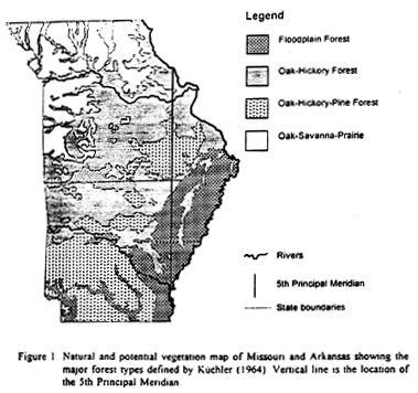
To determine the presettlement characteristics of each unique forest type through which the survey progressed, I divided the GLO data into the following forest types defined by Küchler's (1964) natural vegetation map; Floodplain Forest, Oak-Hickory Forest, Oak-Hickory-Pine Forest, and Oak-Savanna-Prairie (Fig.1).
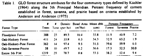
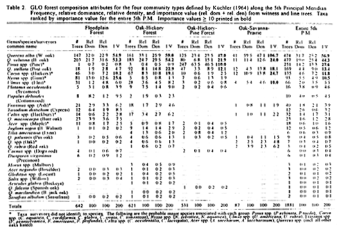
Forest density estimates were calculated considering the shortest witness tree distance at each post as the Q1 distance of the quarter-point method (Cottam and Curtis 1956). From these density estimates, the percent frequency of corners established in forest, savanna, and prairie were determined for each of the forest types defined above using criteria established by Anderson and Anderson (1975). Corners having more than 46.9 trees/ha were considered forest, while corners having less than 46.9 trees/ha and greater than 0.5 trees/ha were considered savanna. Corners where witness trees were not used and surveyors erected a mound or were tree densities were less than 0.5 trees/ha were considered prairie. Forest density and basal area estimates exclude non-forested corners. Results are presented in Table 1. Estimates of relative dominance, relative density, and importance value (IV) for each taxa are presented in Table 2.
GLO surveyors recorded a total of 23 taxa in the southern Floodplain Forest type (Table 2). White and black oak had the highest IVs at 54.9 and 53.3, respectively. Black oaks were most frequently encountered, while white oaks were generally larger. Black gum, water tupelo, and various hickories were close associates. Other important species of this forest type were cottonwood, cypress, bur oak, ash, and elm.
Forest structure attributes (Table 1) indicate that floodplain forests had the highest basal area (10.4 m2/ha) and the second highest density estimates (89.3 trees/ha) of the four forest types examined. It also had the highest proportion of forested corners (51.9%) and the lowest proportion of corners in savanna (40.9%). The remaining 7.2% of corners were established in prairies that were probably floodplain marsh communities.
After traveling 162 miles north, GLO surveyors entered the
uplands of the Missouri Territory. The first forest type they
encountered was Oak-Hickory in which they identified 24 taxa. White
oak and black oak had the highest IVs at 59.0 and 54.2, respectively
(
The Oak-Hickory Forest type had the highest proportion of corners
in savanna (65.2%) of the four forest types examined (
Surveyors recorded a total of 14 taxa in the Oak-Hickory-Pine Forest type (Table 2). Shortleaf and loblolly pines had a combined IV of 110.0, while white oak, black oak, and post oak had IVs of 47.0, 21.9, and 12.1, respectively. Hickory had an IV of only 2.5, indicating it was not an overall important component of this forest type.
Forest structure attributes (Table 1) indicate that this forest type had the highest density estimate among the forest types examined (97.4 trees/ha) and the second highest basal area (9.5 m2/ha). Savanna conditions were estimated to occupy 59.9% of surveyed corners despite the overall higher forest density. Forest conditions occupied only 39.6%. These results indicate that forest densities probably varied greatly throughout this forest type.
Surveyors recorded only 10 taxa in the Oak-Savanna-Prairie forest type which occurred near the northern portion of the 5th PM (Table 2). White oak had an IV of 106.7, followed by Hickory (24.7), Black oak (24.0), and Post oak (18.1). As expected, forest density and basal area estimates were lowest in this forest type at 49.7 trees/ha and 6.2 m2/ha, respectively (Table 1). Percent frequency of prairie was 30%, savanna 52.5% and forest only 17.5%. These results indicate this community was a mosaic of mostly savanna and prairie communities with some forest conditions found probably in groves or as riparian zones along streams.
I extend grateful appreciation to the following individuals who helped in this research effort. Robert Maher, Illinois Natural History Survey, for writing a GLO database entry program. Anjela Redmond, Illinois Natural History Survey, for compiling the GLO records. Dr. Yao Yin, National Biological Survey, for his helpful comments and advice.
Anderson, R. C. and M. R. Anderson. 1975. The presettlement vegetation of Williamson County, Illinois. Castanea 40:345-363.
Cottam, G. and J. T. Curtis. 1956. The use of distance measures in phytosociological sampling. Ecology 37:451-460.
Ebinger, J. 1986. Sugar maple, a management problem in Illinois forests. Transactions of the Illinois State Academy of Science 79:25-30.
Küchler, A. W. 1964. Potential natural vegetation of the conterminous United States. American Geographic Society. Special Publication No. 36. 116 p.
Ladd, D. 1991. Reexamination of the role of fire in Missouri oak woodlands. In: George V. Burger, John E. Ebinger, and Gerould S. Wilhelm, Eds. Proceedings of the Oak Woods Management Workshop. : Eastern Illinois University, Charleston, Illinois.
Packard, S. 1993. Restoring oak ecosystems. Restoration and Management Notes 11:1.